Who What Where WhenREMOVEWHO
|
Author
[USGS (U.S. Geological Survey), Walcott, Charles D., Sudworth, George B.]
Full Title
(View) Plate CIX. A. Little South Gerle Creek at West End of Loon Lake B. Sugar Pine 4 Feet in Diameter Felled by Persistent Burning.
Publisher
Government Printing Office
Author
[USGS (U.S. Geological Survey), Walcott, Charles D., Sudworth, George B.]
Full Title
(View) Plate CX. A. A Gold Miner and his Cabin, Settled in 1849. B. Common Method if Hauling Yellow-Pine Logs to Sawmill.
Publisher
Government Printing Office
Author
[USGS (U.S. Geological Survey), Walcott, Charles D., Sudworth, George B.]
Full Title
(View) Plate CXI. A. Waste in Lumbering. B. Lower Limit of Yellow-Pine Belt.
Publisher
Government Printing Office
Author
[USGS (U.S. Geological Survey), Walcott, Charles D., Sudworth, George B.]
Full Title
(View) Plate CXII. A. South Fork of Consumnes River, near Coyoteville. B. Dense Second Growth of Yellow Pine.
Publisher
Government Printing Office
Author
[USGS (U.S. Geological Survey), Walcott, Charles D., Sudworth, George B.]
Full Title
(View) Plate CXIII. A. Defect in All Large Incense-Cedar Timber. B. Yellow-Pine "Studding" Skidded for Hauling to Gold Mines.
Publisher
Government Printing Office
Author
[USGS (U.S. Geological Survey), Walcott, Charles D., Sudworth, George B.]
Full Title
(View) Plate CXIV. A. Large Mining Plant at Angels Camp, Showing the Great Quantity of Yellow-Pine Cord Wood Consumed. B. Canyon of Coyote Creek, Looking North from a Point 2 miles South of Vallecito.
Publisher
Government Printing Office
Author
[USGS (U.S. Geological Survey), Walcott, Charles D., Sudworth, George B.]
Full Title
Plate CXV. Sonora Quadrangle, California. Land Classification and Density of Standing Timber.
Publisher
Government Printing Office
Author
[USGS (U.S. Geological Survey), Walcott, Charles D., Sudworth, George B.]
Full Title
Plate CXVI. Yosemite Quadrangle, California. Land Classification and Density of Standing Timber. Julius Bien & Co. Lith. N.Y.
Publisher
Government Printing Office
Author
[USGS (U.S. Geological Survey), Walcott, Charles D., Sudworth, George B.]
Full Title
Plate CXVII. Mt. Lyell Quadrangle, California. Land Classification and Density of Standing Timber. Julius Bien & Co. Lith. N.Y.
Publisher
Government Printing Office
Author
[USGS (U.S. Geological Survey), Walcott, Charles D., Gannett, Henry]
Full Title
(Section Title Page) Classification of Lands including Papers by C.H. Fitch, R.B. Marshall, E.C. Barnard, and John B. Leiberg by Henry Gannett.
Publisher
Government Printing Office
Author
[USGS (U.S. Geological Survey), Walcott, Charles D.]
Full Title
(Table of Contents) Classification of Lands.
Publisher
Government Printing Office
Author
[USGS (U.S. Geological Survey), Walcott, Charles D.]
Full Title
(Table of Contents) Classification of Lands. Illustrations.
Publisher
Government Printing Office
Author
[USGS (U.S. Geological Survey), Walcott, Charles D.]
Full Title
(View) Plate CXVIII. A. Oaks in Foothills. B. Abies magnifica, Yosemite National Park.
Publisher
Government Printing Office
Author
[USGS (U.S. Geological Survey), Walcott, Charles D.]
Full Title
(View) Plate CXIX. A. Abies magnifica, Showing Effects of Fire, Yosemite National Park. B. Mountain Meadow, Yosemite National Park.
Publisher
Government Printing Office
Author
[USGS (U.S. Geological Survey), Walcott, Charles D.]
Full Title
(View) Plate CXX. A. Wawona, California. B. Tenaya Lake, Yosemite National Park.
Publisher
Government Printing Office
Author
[USGS (U.S. Geological Survey), Walcott, Charles D.]
Full Title
(View) Plate CXXI. A. Half Dome, Yosemite National Park. B. Looking toward Nevada Falls and Vernal Falls, from Glacier Point, Yosemite National Park.
Publisher
Government Printing Office
Author
[USGS (U.S. Geological Survey), Walcott, Charles D.]
Full Title
(View) Plate CXXII. Sequoia Gigantea, "Grizzly Giant," Mariposa Grove.
Publisher
Government Printing Office
Author
[USGS (U.S. Geological Survey), Walcott, Charles D.]
Full Title
(View) Plate CXXIII. A. Sequoia Gigantea of Nearly All Ages, Mariposa Grove. B. Young Sequoia Gigantea, Mariposa Grove.
Publisher
Government Printing Office
Author
[USGS (U.S. Geological Survey), Walcott, Charles D.]
Full Title
(View) Plate CXXIV. Group of Sequoia Gigantea, Mariposa Grove, California.
Publisher
Government Printing Office
Author
[USGS (U.S. Geological Survey), Walcott, Charles D., Fitch, C.H.]
Full Title
(Section Title Page) Woodland of Indian Territory by C.H. Fitch.
Publisher
Government Printing Office
Author
[USGS (U.S. Geological Survey), Walcott, Charles D.]
Full Title
(Table of Contents) Woodland of Indian Territory.
Publisher
Government Printing Office
Author
[USGS (U.S. Geological Survey), Walcott, Charles D.]
Full Title
(Table of Contents) Woodland of Indian Territory. Illustrations.
Publisher
Government Printing Office
Author
[USGS (U.S. Geological Survey), Walcott, Charles D.]
Full Title
(Section Title Page) Timber Conditions of the Pine Region of Minnesota by H.B.Ayers.
Publisher
Government Printing Office
Author
[USGS (U.S. Geological Survey), Walcott, Charles D.]
Full Title
(Table of Contents) Timber Conditions of the Pine Region of Minnesota.
Publisher
Government Printing Office
Author
[USGS (U.S. Geological Survey), Walcott, Charles D.]
Full Title
(Table of Contents) Timber Conditions of the Pine Region of Minnesota. (continued).
Publisher
Government Printing Office
Author
[USGS (U.S. Geological Survey), Walcott, Charles D.]
Full Title
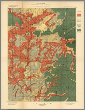
Plate CXXV. San Jacinto Quadrangle, California. Land Classification and Density of Standing Timber.
Publisher
Government Printing Office
Author
[USGS (U.S. Geological Survey), Walcott, Charles D.]
Full Title
Plate CXXVI. Port Orford Quadrangle, Oregon, Land Classification and Density of Standing Timber.
Publisher
Government Printing Office
Author
[USGS (U.S. Geological Survey), Walcott, Charles D., Gannett, Henry]
Full Title
Plate CXXVII. Coos Bay Quadrangle, Oregon, Land Classification and Density of Standing Timber.
Publisher
Government Printing Office
Author
[USGS (U.S. Geological Survey), Walcott, Charles D., Gannett, Henry]
Full Title
Plate CXXVIII. Roseburg Quadrangle, Oregon, Land Classification and Density of Standing Timber.
Publisher
Government Printing Office
Author
[USGS (U.S. Geological Survey), Gannett, Henry, Walcott, Charles D.]
Full Title
Plate CXXIX. Tacoma Quadrangle, Washington, Land Classification and Density of Standing Timber.
Publisher
Government Printing Office
Author
[USGS (U.S. Geological Survey), Walcott, Charles D., Gannett, Henry]
Full Title
Plate CXXX. Seattle Quadrangle, Washington, Land Classification and Density of Standing Timber.
Publisher
Government Printing Office
Author
[USGS (U.S. Geological Survey), Gannett, Henry, Walcott, Charles D.]
Full Title
Plate CXXXI. Mount Stuart Quadrangle, Washington, Land Classification and Density of Standing Timber.
Publisher
Government Printing Office
Author
[USGS (U.S. Geological Survey), Walcott, Charles D., Gannett, Henry]
Full Title
Plate CXXXII. Ellensburg Quadrangle, Washington, Land Classification and Density of Standing Timber. Julis Bien & Co. Lith. N.Y.
Publisher
Government Printing Office
Author
[USGS (U.S. Geological Survey), Gannett, Henry, Walcott, Charles D.]
Full Title
Plate CXXXIII. Chelan Quadrangle, Washington, Land Classification and Density of Standing Timber. Julis Bien & Co. Lith. N.Y.
Publisher
Government Printing Office
Author
[USGS (U.S. Geological Survey), Gannett, Henry, Walcott, Charles D.]
Full Title
Plate CXXXIV. Spokane Quadrangle, Washington-Idaho, Land Classification and Density of Standing Timber. Julis Bien & Co. Lith. N.Y.
Publisher
Government Printing Office
Author
[USGS (U.S. Geological Survey), Walcott, Charles D., Leiberg, John B., Barnard, E.C., Searle, A.B.]
Full Title
Plate CXXXV. Sandpoint Quadrangle, (Kootenai Co) Idaho, Land Classification and Density of Standing Timber. Julis Bien & Co. Lith. N.Y.
Publisher
Government Printing Office
Author
[USGS (U.S. Geological Survey), Gannett, Henry, Walcott, Charles D.]
Full Title
Plate CXXXVI. Hamilton Quadrangle, Montana-Idaho, Land Classification and Density of Standing Timber. Julis Bien & Co. Lith. N.Y.
Publisher
Government Printing Office
Author
[USGS (U.S. Geological Survey), Walcott, Charles D., Barnard, E.C.]
Full Title
Plate CXXXVII. Fortymile Quadrangle, Alaska, Land Classification and Density of Standing Timber. Julis Bien & Co. Lith. N.Y.
Publisher
Government Printing Office
Author
[USGS (U.S. Geological Survey), Walcott, Charles D., Tweedy, Frank]
Full Title
Plate CXXXVIII. Dayton Quadrangle, Wyoming, Land Classification and Density of Standing Timber. Julis Bien & Co. Lith. N.Y.
Publisher
Government Printing Office
Author
[USGS (U.S. Geological Survey), Walcott, Charles D., Tweedy, Frank]
Full Title
Plate CXXXIX. Bald Mountain Quadrangle, Wyoming, Land Classification and Density of Standing Timber. Julis Bien & Co. Lith. N.Y.
Publisher
Government Printing Office
Author
[USGS (U.S. Geological Survey), Walcott, Charles D., Matthes, F.E.]
Full Title
Plate CXL. Cloud Peak Quadrangle, Wyoming, Land Classification and Density of Standing Timber. Julis Bien & Co. Lith. N.Y.
Publisher
Government Printing Office
Author
[USGS (U.S. Geological Survey), Walcott, Charles D., Herron, W.H.]
Full Title
Plate CXLI. Newcastle Quadrangle, Wyoming - South Dakota, Land Classification and Density of Standing Timber. Julis Bien & Co. Lith. N.Y.
Publisher
Government Printing Office
Author
[USGS (U.S. Geological Survey), Walcott, Charles D.]
Full Title
Plate CXLII. Map of Indian Territory, Showing Distribution of Woodland, Compiled under the Direction of C.H.Fitch by Gilbert Thompson, F.E. Matthes and M.L. Cudlipp. 1899.
Publisher
Government Printing Office
Author
[USGS (U.S. Geological Survey), Walcott, Charles D.]
Full Title
Plate CXLIII. Pine Region of Minnesota Showing Classification of Lands, Compiled under the direction of Henry Gannet, Geographer in Charge, by H.B. Ayres. 1899. Julius Bien & Co. Lith. N.Y.
Publisher
Government Printing Office
Author
[U.S. Geological Survey, Alpha, Tau Rho, Detterman, Janis S., Morley, James M.]
Full Title
(Covers to) Atlas of Oblique Maps, A Collection of Landform Portrayals of Selected Areas of the World.
Publisher
U.S. Geological Survey
Author
[U.S. Geological Survey, Alpha, Tau Rho, Detterman, Janis S., Morley, James M.]
Full Title
(Title Page) Atlas of Oblique Maps, A Collection of Landform Portrayals of Selected Areas of the World. By Tau Rho Alpha, Janis S. Detterman, and James M. Morley. This folio comprises scale-accurate, obliquely viewed maps compiled from 1961-1986 that portray the physiography of selected areas of the ocean floor and continents. U.S. Geological Survey Miscellaneous Investigations Series I-1799.
Publisher
U.S. Geological Survey
Author
[U.S. Geological Survey, Alpha, Tau Rho, Detterman, Janis S., Morley, James M.]
Full Title
(Title Page Verso) Department of Interior ... Preface.
Publisher
U.S. Geological Survey
Author
[U.S. Geological Survey, Alpha, Tau Rho, Detterman, Janis S., Morley, James M.]
Full Title
(Table of Contents) (Text Page) Introduction. Characteristics of Oblique Maps. History. Armin L. Lobeck.
Publisher
U.S. Geological Survey
Author
[U.S. Geological Survey, Alpha, Tau Rho, Detterman, Janis S., Morley, James M.]
Full Title
(Text Page) Erwin J. Raisz. Philip B. King.
Publisher
U.S. Geological Survey
Author
[U.S. Geological Survey, Alpha, Tau Rho, Detterman, Janis S., Morley, James M.]
Full Title
(Text Page) Oblique Map Methods Used for Maps in this Atlas. Conclusion. Acknowledgments. References.
Publisher
U.S. Geological Survey
|