Browse All

1879 Map of portions of Utah and Arizona show … [Exploration Book, State Atlas] Map of portions of Utah and Arizona show … |

1952 Italia Fisica. World Atlas Italia Fisica. (insets) Geologia and Den … |

1953 U.S.A. Physiographic. World Atlas U.S.A. Physiographic. |

1878 (Topographic and glacial feature map of … Geologic Atlas (Topographic and glacial feature map of … |

1878 (Topographic and glacial feature map of … Geologic Atlas (Topographic and glacial feature map of … |

1878 (Topographic and glacial feature map of … Geologic Atlas (Topographic and glacial feature map of … |

1878 (Topographic and glacial feature map of … Geologic Atlas (Topographic and glacial feature map of … |

1878 (Topographic and glacial feature map of … Geologic Atlas (Topographic and glacial feature map of … |

1878 Composite: New Hampshire topographic, gl … Geologic Atlas (Composite of Topographic and glacial fe … |

1892 Thatigkeit des Erdinnern. Geologic Atlas Thatigkeit des Erdinnern. Vulkane und St … |

1892 Grund u. Boden. Geologic Atlas Grund und Boden. Bearbeitet v. Dr. C. Ro … |

1892 Eisverbreitung. Geologic Atlas Eisverbreitung, einst und jetzt. Polar A … |

1892 Gletscherkarte. Geologic Atlas Gletscherkarte. Entw. v. Herm. Berghaus … |

1892 Oceanien. Geologic Atlas Oceanien. (with) Victoria nach Brough Sm … |

1906 Mountains, Table Lands, Plains & Valleys … World Atlas The Mountains, Table Lands, Plains & Val … |

1906 The Mountains, Table Lands, Plains & Val … World Atlas The Mountains, Table Lands, Plains & Val … |

1879 Bird's eye view of the Black Hills to il … [Exploration Book, Regional Atlas] Bird's eye view of the Black Hills to il … |
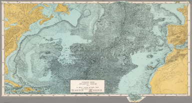
1957 Physiographic Diagram, Atlantic Ocean (S … Separate Map Physiographic Diagram, Atlantic Ocean (S … |

1857 VII. Geological agency of the winds Physical Atlas VII. Geological agency of the winds. D. … |

1827 Saxe mineralogique. Physical Atlas Carte mineralogique de la Saxe. Distribu … |

1827 St. Pierre Plateau. Physical Atlas Coupe perpendiculaire d'un point du Plat … |

1827 Creney pres Troyes. Physical Atlas Vue d'une carriere de craye a Creney pre … |

1827 Mascareigne, Vesuve. Physical Atlas Premier age du Volcan de Mascareigne en … |

1827 Vesuve, Dolomieu. Physical Atlas Cratere du Mont Vesuve, avant l'eruption … |

1827 Dolomieu. Physical Atlas Second etat du cratere Dolomieu, volcan … |

1827 Mamelon, Bory. Physical Atlas Mamelon Central, volcan de Mascareigne. … |

1827 Antrim, Raghery. Physical Atlas Comte d'Antrim. (with) Vue du Cap de Doo … |

1827 Pave des Geans en Irlande. Physical Atlas Pave des Geans en Irlande, cote occident … |

1827 Pave des Geans en Irlande. Physical Atlas Pave des Geans en Irlande, cote oriental … |

1827 Ile de Staffa. Physical Atlas Basaltes courbes de l'Ile de Staffa. Gra … |

1827 Ashna Crogs, Mull. Physical Atlas Cirque volcanique d'Ashna Crogs, Ile de … |

1827 Lacs volcaniques. Physical Atlas Lacs volcaniques de la IIe. et IIIe. epo … |

1827 Lacs volcaniques. Physical Atlas Lacs volcaniques de la Iere, IIeme. et I … |

1827 Volcans Haute Loire. Physical Atlas Volcans. 2e. epoque. Culots avec les cou … |

1827 Environs de Clermont. Physical Atlas Volcans IIIeme. et derniere epoque. Envi … |

1827 Conjecturale de l'Atlantide. Physical Atlas Carte conjecturale de l'Atlantide d'apre … |

1908 Cover: Atlas California earthquake, Apri … Physical Atlas (Covers to) Atlas of maps and seismogram … |

1908 Title Page: Atlas California earthquake, … Physical Atlas (Title Page to) Atlas of maps and seismo … |

1908 Contents: Atlas California earthquake, A … Physical Atlas (Contents to) Atlas of maps and seismogr … |

1908 Geomorphic map, California, Nevada, port … Physical Atlas Geomorphic map of California and Nevada … |

1908 Coast of California showing San Andreas … Physical Atlas Map of a portion of the coast of Califor … |

1908 San Andreas Rift near Fort Ross. Physical Atlas Detail map of a typical portion of the S … |

1908 San Francisco Bay showing San Andreas Ri … Physical Atlas Map of the region about San Francisco Ba … |

1908 Coast Ranges showing San Andreas Rift. Physical Atlas Map of a portion of the Coast Ranges of … |

1908 Mt. Pinos quadrangle showing San Andreas … Physical Atlas California, Mt. Pinos quadrangle of the … |

1908 Tejon quadrangle showing San Andreas Rif … Physical Atlas California, Tejon quadrangle of the U.S. … |

1908 Palmdale quadrangle showing San Andreas … Physical Atlas California, Palmdale quadrangle of the U … |

1908 Rock Creek quadrangle showing San Andrea … Physical Atlas California, Rock Creek quadrangle of the … |

1908 San Antonio quadrangle showing San Andre … Physical Atlas California, San Antonio quadrangle of th … |

1908 Hesperia quadrangle showing San Andreas … Physical Atlas California, Hesperia quadrangle of the U … |