Who What Where WhenREMOVEWHEREShow More |
Author
King, Clarence
Full Title
(Covers to) Engineer Department U.S.A. Geological and Topographical Atlas Accompanying the Report of the Geological Exploration of the Fortieth Parallel Made by the Authority of the Honorable Secretary of War under the direction of Brig. and Brvt. Major General A.A. Humphreys, Chief of Engineers U.S.A. by Clarence King, U.S. Geologist in Charge, 1876. Julius Bien Lith.
Publisher
Julius Bien
Author
King, Clarence
Full Title
(Title Page to) Engineer Department U.S.A. Geological and Topographical Atlas Accompanying the Report of the Geological Exploration of the Fortieth Parallel Made by the Authority of the Honorable Secretary of War under the direction of Brig. and Brvt. Major General A.A. Humphreys, Chief of Engineers U.S.A. by Clarence King, U.S. Geologist in Charge, 1876. Julius Bien Lith.
Publisher
Julius Bien
Author
King, Clarence
Full Title
(Index Page to) Engineer Department U.S.A. Geological and Topographical Atlas Accompanying the Report of the Geological Exploration of the Fortieth Parallel Made by the Authority of the Honorable Secretary of War under the direction of Brig. and Brvt. Major General A.A. Humphreys, Chief of Engineers U.S.A. by Clarence King, U.S. Geologist in Charge, 1876. Julius Bien Lith.
Publisher
Julius Bien
Author
Wheeler, G.M.
Full Title
Atlas Sheet Number 58. Parts Of E. California, S.E. Nevada, N.W. Arizona & S.W. Utah. Atlas Sheet Number 66. Weyss, Herman & Aguirre, Del. Expeditions of 1872 & 1873, Under the Command of 1st. Lieut. Geo. M. Wheeler, Corps of Engineers, U.S. Army. Geological Assistants: G.K. Gilbert, A.R. Marvine and E.E. Howell. U.S. Geographical Surveys West Of The One-Hundredth Meridian.
Publisher
U.S.
Author
Becker, George F.
Full Title
Geological Map of the Sulphur Bank District. U.S. Geological Survey. Monograph XIII, Atlas Sheet IV. S.H. Bodfish 1882, J.D. Hoffman 1884, Topographers. Giles Litho. & Liberty Printing Co. Geo. F. Becker, Geologist in charge.
Publisher
United States Geological Survey
Author
Becker, George F.
Full Title
Geological Map of the Knoxville District. U.S. Geological Survey. Monograph XIII, Atlas Sheet V. Topography by J.D. Hoffman 1883. Geo. F. Becker, Geologist in charge. Topographical Map of the Region of Clear Lake. Compiled by C.F. Hoffmann. Geo. F. Becker, Geologist in charge.
Publisher
United States Geological Survey
Author
Becker, George F.
Full Title
Geological Map of the New Idria District. U.S. Geological Survey. Monograph XIII, Atlas Sheet VI. J.D. Hoffman, Topographer. Giles Litho. & Liberty Printing Co. N.Y. Geo. F. Becker, Geologist in charge.
Publisher
United States Geological Survey
Author
Becker, George F.
Full Title
Geological Map of the New Almaden Mining District. U.S. Geological Survey. Monograph XIII, Atlas Sheet VII. Topography by S.W. Bodfish and others. Giles Litho. & Liberty Printing Co. N.Y. Geo. F. Becker, Geologist in charge.
Publisher
United States Geological Survey
Author
Becker, George F.
Full Title
Ore-Bodies and Topography of Mine-Hill, New Almaden. U.S. Geological Survey. Monograph XIII, Atlas Sheet VIII. Compiled by F. Reade 1885. Giles Litho. & Liberty Printing Co. N.Y. Geo. F. Becker, Geologist in charge.
Publisher
United States Geological Survey
Author
Becker, George F.
Full Title
Plan of the New Almaden Mine. U.S. Geological Survey. Monograph XIII, Atlas Sheet IX. Compiled by F. Reade 1885. Giles Litho. & Liberty Printing Co. N.Y. Geo. F. Becker, Geologist in charge.
Publisher
United States Geological Survey
Author
Becker, George F.
Full Title
Longitudinal Section of the South Ore Channel. New Almaden Mine. U.S. Geological Survey. Monograph XIII, Atlas Sheet X. Compiled by F. Reade 1885. Giles Litho. & Liberty Printing Co. N.Y. Geo. F. Becker, Geologist in charge.
Publisher
United States Geological Survey
Author
Becker, George F.
Full Title
North and South Section , 550 Feet West of Randol Shaft, New Almaden Mine. North and South Section through the Randol Shaft, New Almaden Mine. U.S. Geological Survey. Monograph XIII, Atlas Sheet XI. Compiled by F. Reade 1885. Geo. F. Becker, Geologist in charge.
Publisher
United States Geological Survey
Author
Becker, George F.
Full Title
East and West Vertical Section, New Almaden Mine. U.S. Geological Survey. Monograph XIII, Atlas Sheet XII. Compiled by F. Reade 1885. Geo. F. Becker, Geologist in charge.
Publisher
United States Geological Survey
Author
Becker, George F.
Full Title
Plan of the Clay Walls, New Almaden Mine. U.S. Geological Survey. Monograph XIII, Atlas Sheet XIII. Compiled by F. Reade 1885. Giles Litho. & Liberty Printing Co. N.Y. Geo. F. Becker, Geologist in charge.
Publisher
United States Geological Survey
Author
Berghaus, Hermann
Full Title
Nord-Amerika. Ubersicht von Nord-Amerika. (with) Virginia-Silber-Minen. (with) Das Yosemite-Thal. (with) Landenge von Tehuantepec n. J.C. Spear 1871. (with) Landenge von Nicaragua. (with) Die Krater des Turrialba. (with) Landenge von Panama. (with) Seeboden der New-York-Bay. (with) Popocatepetl. (with) Citlaltepetl. (with) Canons des Colorado. (with) Yellowstone-National-Park. (with) Reykjanes und Geyser nach Th. Thoroddsen. Entw. v. Herm. Berghaus 1886, Ausg. 1887. Nebenkarten gez. v. M. Risch. Gotha: Justus Perthes (1892)
Publisher
Justus Perthes
Author
[Jennings, Charles W., California Division of Mines and Geology]
Full Title
Fault Map of California , w/ locations of Volcanoes, Thermal Springs, and Thermal Wells.
Publisher
Williams & Heintz Map Corp
Author
[Jennings, Charles W., Strand, R.G., Rogers, T.H.]
Full Title
Geologic Map of California.
Publisher
Charles W. Jennings
Author
Russell, Israel C. (Israel Cook), 1852-1906.
Full Title
Tufa domes in Mono Lake, California. (to accompany) Geological history of Lake Lahontan : a quaternary lake of Northwestern Nevada. (series title) Department of Interior : Monographs of the United States Geological Survey, vol. XI. (on upper margin) U.S. Geological Survey; Lake Lahontan PL. XLIII.
Publisher
U.S. Govt. Print Office
Author
Russell, Israel C. (Israel Cook), 1852-1906.
Full Title
Post - quaternary fault lines. Julius Bien & Co. Lith. (to accompany) Geological history of Lake Lahontan : a quaternary lake of Northwestern Nevada. (series title) Department of Interior : Monographs of the United States Geological Survey, vol. XI. (on upper margin) U.S. Geological Survey; Lake Lahontan PL. XLIV.
Publisher
U.S. Govt. Print Office
Author
Russell, Israel C. (Israel Cook), 1852-1906.
Full Title
Post - quaternary fault on the south shore of Humboldt Lake. (to accompany) Geological history of Lake Lahontan : a quaternary lake of Northwestern Nevada. (series title) Department of Interior : Monographs of the United States Geological Survey, vol. XI. (on upper margin) U.S. Geological Survey; Lake Lahontan PL. XLV.
Publisher
U.S. Govt. Print Office
Author
Russell, Israel C. (Israel Cook), 1852-1906.
Full Title
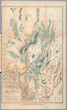
Lake Lahontan : a quaternary lake of northwestern Nevad, by Israel C. Russell. Assisted by A.L. Webster, W.D. Johnson, cartographers ; W.J. McGee. GEO. M. Wright, geologists. Mountain shading, by W.J. Hays. Topography compiled by Eugene Rickseker ... (to accompany) Geological history of Lake Lahontan : a quaternary lake of Northwestern Nevada. (series title) Department of Interior : Monographs of the United States Geological Survey, vol. XI. (on upper margin) U.S. Geological Survey; Lake Lahontan PL. XLVI.
Publisher
U.S. Govt. Print Office
Author
[Branner, John Casper, California. State Earthquake Investigation Commission, Gilbert, G. K., Lawson, Andrew C., Reid, Harry Fielding]
Full Title
(Covers to) Atlas of maps and seismograms accompanying the report of the State Earthquake Investigation Commission upon the California earthquake of April 18, 1906. Andrew C. Lawson, G.K. Gilbert, H.F. Reid, J.C. Branner, A.O. Leuschner, George Davidson, Charles Burckhalter, W.W. Campbell. Carnegie Institution of Washington. Washington, D.C. 1908. (seal) Carnegie Institution of Washington 1902.
Publisher
Carnegie Institution
Author
[Branner, John Casper, California. State Earthquake Investigation Commission, Gilbert, G. K., Lawson, Andrew C., Reid, Harry Fielding]
Full Title
(Title Page to) Atlas of maps and seismograms accompanying the report of the State Earthquake Investigation Commission upon the California earthquake of April 18, 1906. Andrew C. Lawson, G.K. Gilbert, H.F. Reid, J.C. Branner, A.O. Leuschner, George Davidson, Charles Burckhalter, W.W. Campbell. Carnegie Institution of Washington. Washington, D.C. 1908. (seal) Carnegie Institution of Washington 1902.
Publisher
Carnegie Institution
Author
[Branner, John Casper, California. State Earthquake Investigation Commission, Gilbert, G. K., Lawson, Andrew C., Reid, Harry Fielding]
Full Title
(Contents to) Atlas of maps and seismograms accompanying the report of the State Earthquake Investigation Commission upon the California earthquake of April 18, 1906. Andrew C. Lawson, G.K. Gilbert, H.F. Reid, J.C. Branner, A.O. Leuschner, George Davidson, Charles Burckhalter, W.W. Campbell. Carnegie Institution of Washington. Washington, D.C. 1908. (seal) Carnegie Institution of Washington 1902.
Publisher
Carnegie Institution
Author
California. State Earthquake Investigation Commission
Full Title
Geomorphic map of California and Nevada with portions of Oregon and Idaho showing the diastrophic character of the relief, the steep descent from the sub-continental shelf to the floor of the Pacific, and the more important known faults. Earthquake Investigation Commission. Drawn by M. Solem. A. Hoen & Co., Baltimore. (Carnegie Institution of Washington, 1908)
Publisher
Carnegie Institution
Author
California. State Earthquake Investigation Commission
Full Title
Map of a portion of the coast of California showing the San Andreas Rift from Point Arena to Fort Ross and the trace of the fault of April 18, 1906. Earthquake Investigation Commission. Julius Bien & Co., N.Y. (Carnegie Institution of Washington. 1908)
Publisher
Carnegie Institution
Author
[California. State Earthquake Investigation Commission, Matthes, Francois E.]
Full Title
Detail map of a typical portion of the San Andreas Rift near Fort Ross, Sonoma County, California showing its geomorphic features and the trace of the fault by Francois E. Matthes. Earthquake Investigation Commission. A. Hoen & Co., Baltimore. (Carnegie Institution of Washington. 1908)
Publisher
Carnegie Institution
Author
California. State Earthquake Investigation Commission
Full Title
Map of the region about San Francisco Bay showing the relation of the city of San Francisco to the San Andreas Rift, the fault of April 18, 1906 and the fault of October 21, 1868. Earthquake Investigation Commission. Julius Bien & Co., Lith., N.Y. (Carnegie Institution of Washington. 1908)
Publisher
Carnegie Institution
Author
California. State Earthquake Investigation Commission
Full Title
Map of a portion of the Coast Ranges of California showing the San Andreas Rift. Earthquake Investigation Commission. Julius Bien & Co., Lith., N.Y. (Carnegie Institution of Washington. 1908)
Publisher
Carnegie Institution
Author
[California. State Earthquake Investigation Commission, U.S. Geological Survey]
Full Title
California, Mt. Pinos quadrangle of the U.S. Geological Survey showing the San Andreas Rift. Earthquake Investigation Commission. (Carnegie Institution of Washington. 1908)
Publisher
Carnegie Institution
Author
[California. State Earthquake Investigation Commission, U.S. Geological Survey]
Full Title
California, Tejon quadrangle of the U.S. Geological Survey showing the San Andreas Rift. Earthquake Investigation Commission. (Carnegie Institution of Washington. 1908)
Publisher
Carnegie Institution
Author
[California. State Earthquake Investigation Commission, U.S. Geological Survey]
Full Title
California, Palmdale quadrangle of the U.S. Geological Survey showing the San Andreas Rift. Earthquake Investigation Commission. A. Hoen & Co., Baltimore. (Carnegie Institution of Washington. 1908)
Publisher
Carnegie Institution
Author
[California. State Earthquake Investigation Commission, U.S. Geological Survey]
Full Title
California, Rock Creek quadrangle of the U.S. Geological Survey showing the San Andreas Rift. Earthquake Investigation Commission. Andrew B. Graham Co., Lithographers, Washington, D.C. (Carnegie Institution of Washington. 1908)
Publisher
Carnegie Institution
Author
[California. State Earthquake Investigation Commission, U.S. Geological Survey]
Full Title
California, San Antonio quadrangle of the U.S. Geological Survey showing the San Andreas Rift. Earthquake Investigation Commission. Andrew B. Graham Co., Lithographers, Washington, D.C. (Carnegie Institution of Washington. 1908)
Publisher
Carnegie Institution
Author
[California. State Earthquake Investigation Commission, U.S. Geological Survey]
Full Title
California, Hesperia quadrangle of the U.S. Geological Survey showing the San Andreas Rift. Earthquake Investigation Commission. Andrew B. Graham Co., Lithographers, Washington, D.C. (Carnegie Institution of Washington. 1908)
Publisher
Carnegie Institution
Author
[California. State Earthquake Investigation Commission, U.S. Geological Survey]
Full Title
California, San Bernardino quadrangle of the U.S. Geological Survey showing the San Andreas Rift. Earthquake Investigation Commission. Andrew B. Graham Co., Lithographers, Washington, D.C. (Carnegie Institution of Washington. 1908)
Publisher
Carnegie Institution
Author
[California. State Earthquake Investigation Commission, U.S. Geological Survey]
Full Title
California, Redlands quadrangle of the U.S. Geological Survey showing the San Andreas Rift. Earthquake Investigation Commission. Andrew B. Graham Co., Lithographers, Washington, D.C. (Carnegie Institution of Washington. 1908)
Publisher
Carnegie Institution
Author
[California. State Earthquake Investigation Commission, U.S. Geological Survey]
Full Title
California, San Gorgonio quadrangle of the U.S. Geological Survey showing the San Andreas Rift and the Mission Creek Fault. Earthquake Investigation Commission. Andrew B. Graham Co., Lithographers, Washington, D.C. (Carnegie Institution of Washington. 1908)
Publisher
Carnegie Institution
Author
[California. State Earthquake Investigation Commission, U.S. Geological Survey]
Full Title
California, San Jacinto quadrangle of the U.S. Geological Survey showing the San Andreas Rift, the Mission Creek Fault and the San Jacinto Fault. Earthquake Investigation Commission. Andrew B. Graham Co., Lithographers, Washington, D.C. (Carnegie Institution of Washington. 1908)
Publisher
Carnegie Institution
Author
California. State Earthquake Investigation Commission
Full Title
Map of the city of Santa Rosa, Sonoma County, California showing the portions destroyed by the earthquake of April 18, 1906, and by the fire consequent thereto. Earthquake Investigation Commission. A. Hoen & Co., Baltimore. (Carnegie Institution of Washington. 1908)
Publisher
Carnegie Institution
Author
[California. State Earthquake Investigation Commission, Lawson, Andrew C., Wood, Harry O.]
Full Title
Geological map of the city of San Francisco by Andrew C. Lawson. To accompany the paper by H.O. Wood. Earthquake Investigation Commission. A. Hoen & Co. (Carnegie Institution of Washington. 1908)
Publisher
Carnegie Institution
Author
[California. State Earthquake Investigation Commission, Wood, Harry O.]
Full Title
Geological profiles with corresponding intensity curves across the city of San Francisco. To accompany the paper by H.O. Wood. Earthquake Investigation Commission. A. Hoen & Co. (Carnegie Institution of Washington. 1908)
Publisher
Carnegie Institution
Author
[California. State Earthquake Investigation Commission, Wood, Harry O.]
Full Title
Map of San Francisco showing distribution of apparent intensity of the earthquake shock by H.O. Wood. Earthquake Investigation Commission. A. Hoen & Co., Baltimore. (Carnegie Institution of Washington. 1908)
Publisher
Carnegie Institution
Author
California. State Earthquake Investigation Commission
Full Title
Map of the city of San Francisco showing the streets and the burnt area, 1906. Earthquake Investigation Commission. Britton & Rey, engravers, San Francisco. (Carnegie Institution of Washington. 1908)
Publisher
Carnegie Institution
Author
[California. State Earthquake Investigation Commission, U.S. Geological Survey]
Full Title
California, San Mateo quadrangle of the U.S. Geological Survey showing the distribution of apparent intensity, the known faults, and the routes examined. Earthquake Investigation Commission. A. Hoen & Co., Baltimore. (Carnegie Institution of Washington. 1908)
Publisher
Carnegie Institution
Author
[California. State Earthquake Investigation Commission, U.S. Geological Survey]
Full Title
California, Santa Cruz quadrangle of the U.S. Geological Survey showing the distribution of apparent intensity, the known faults, the routes examined and the numbered localities referred to in the text. Earthquake Investigation Commission. A. Hoen & Co., Baltimore. (Carnegie Institution of Washington. 1908)
Publisher
Carnegie Institution
Author
California. State Earthquake Investigation Commission
Full Title
Map of California and Nevada showing the distribution of apparent intensity in the region affected by the earthquake of April 18, 1906. Drawn by M. Solem. Earthquake Investigation Commission. A. Hoen & Co., Baltimore. (Carnegie Institution of Washington. 1908)
Publisher
Carnegie Institution
Author
California. State Earthquake Investigation Commission
Full Title
Map of the Coast Range Region of Middle California showing the distribution of earth movement on April 18, 1906 as revealed by the displacement of the triangulation stations of the Coast and Geodetic Surveyed, determined by resurvey, 1906-07. Drawn by M. Solem. Earthquake Investigation Commission. A. Hoen & Co., Baltimore. (Carnegie Institution of Washington. 1908)
Publisher
Carnegie Institution
Author
California. State Earthquake Investigation Commission
Full Title
Distribution of earth movement on April 18, 1906 and in 1868 as revealed by the displacement of the triangulation stations of the Coast and Geodetic Surveyed, determined by resurvey, 1906-07. Earthquake Investigation Commission. A. Hoen & Co., Baltimore. (Carnegie Institution of Washington. 1908)
Publisher
Carnegie Institution
|