Browse All

1876 Cover: Geological, topographical atlas, … Geologic Atlas (Covers to) Engineer Department U.S.A. G … |

1876 Title Page: Geological and topographical … Geologic Atlas (Title Page to) Engineer Department U.S. … |

1876 Index: Geological, topographical atlas, … Geologic Atlas (Index Page to) Engineer Department U.S. … |

1873 58, 66. Parts Of E. California, S.E. Nev … National Atlas Atlas Sheet Number 58. Parts Of E. Calif … |

1887 Geological Map of the Sulphur Bank Distr … Geologic Atlas Geological Map of the Sulphur Bank Distr … |

1887 Geological Map of the Knoxville District … Geologic Atlas Geological Map of the Knoxville District … |

1887 Geological Map of the New Idria District … Geologic Atlas Geological Map of the New Idria District … |

1887 Geological Map of the New Almaden Mining … Geologic Atlas Geological Map of the New Almaden Mining … |

1887 Ore-Bodies and Topography of Mine-Hill, … Geologic Atlas Ore-Bodies and Topography of Mine-Hill, … |

1887 Plan of the New Almaden Mine. Geologic Atlas Plan of the New Almaden Mine. U.S. Geolo … |

1887 Longitudinal Section of the South Ore Ch … Geologic Atlas Longitudinal Section of the South Ore Ch … |

1887 North and South Sections vicinity of the … Geologic Atlas North and South Section , 550 Feet West … |

1887 East and West Vertical Section, New Alma … Geologic Atlas East and West Vertical Section, New Alma … |

1887 Plan of the Clay Walls, New Almaden Mine … Geologic Atlas Plan of the Clay Walls, New Almaden Mine … |

1892 Nord-Amerika. Geologic Atlas Nord-Amerika. Ubersicht von Nord-Amerika … |

1975 California -- Faults. Wall Map Fault Map of California , w/ locations o … |

1977 California -- Geology. Wall Map Geologic Map of California. |

1885 Plate XLIII: Tufa domes in Mono Lake, Ca … Geology Book Tufa domes in Mono Lake, California. (to … |

1885 Plate XLIV: Post - quaternary fault line … Geology Book Post - quaternary fault lines. Julius Bi … |

1885 Plate XLV: Post - quaternary fault on th … Geology Book Post - quaternary fault on the south sho … |
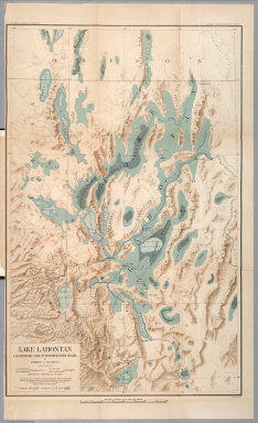
1885 Plate XLVI: Lake Lahontan : a quaternary … Geology Book Lake Lahontan : a quaternary lake of nor … |

1908 Cover: Atlas California earthquake, Apri … Physical Atlas (Covers to) Atlas of maps and seismogram … |

1908 Title Page: Atlas California earthquake, … Physical Atlas (Title Page to) Atlas of maps and seismo … |

1908 Contents: Atlas California earthquake, A … Physical Atlas (Contents to) Atlas of maps and seismogr … |

1908 Geomorphic map, California, Nevada, port … Physical Atlas Geomorphic map of California and Nevada … |

1908 Coast of California showing San Andreas … Physical Atlas Map of a portion of the coast of Califor … |

1908 San Andreas Rift near Fort Ross. Physical Atlas Detail map of a typical portion of the S … |

1908 San Francisco Bay showing San Andreas Ri … Physical Atlas Map of the region about San Francisco Ba … |

1908 Coast Ranges showing San Andreas Rift. Physical Atlas Map of a portion of the Coast Ranges of … |

1908 Mt. Pinos quadrangle showing San Andreas … Physical Atlas California, Mt. Pinos quadrangle of the … |

1908 Tejon quadrangle showing San Andreas Rif … Physical Atlas California, Tejon quadrangle of the U.S. … |

1908 Palmdale quadrangle showing San Andreas … Physical Atlas California, Palmdale quadrangle of the U … |

1908 Rock Creek quadrangle showing San Andrea … Physical Atlas California, Rock Creek quadrangle of the … |

1908 San Antonio quadrangle showing San Andre … Physical Atlas California, San Antonio quadrangle of th … |

1908 Hesperia quadrangle showing San Andreas … Physical Atlas California, Hesperia quadrangle of the U … |

1908 San Bernardino quadrangle showing San An … Physical Atlas California, San Bernardino quadrangle of … |

1908 Redlands quadrangle showing San Andreas … Physical Atlas California, Redlands quadrangle of the U … |

1908 San Gorgonio quadrangle showing San Andr … Physical Atlas California, San Gorgonio quadrangle of t … |

1908 San Jacinto quadrangle showing San Andre … Physical Atlas California, San Jacinto quadrangle of th … |

1908 Santa Rosa, portions destroyed by earthq … Physical Atlas Map of the city of Santa Rosa, Sonoma Co … |

1908 Geological map San Francisco. Physical Atlas Geological map of the city of San Franci … |

1908 Geological profiles, San Francisco. Physical Atlas Geological profiles with corresponding i … |

1908 San Francisco intensity of earthquake. Physical Atlas Map of San Francisco showing distributio … |

1908 San Francisco burnt area, 1906. Physical Atlas Map of the city of San Francisco showing … |

1908 San Mateo quadrangle showing intensity, … Physical Atlas California, San Mateo quadrangle of the … |

1908 Santa Cruz quadrangle showing intensity, … Physical Atlas California, Santa Cruz quadrangle of the … |

1908 California, Nevada showing intensity. Physical Atlas Map of California and Nevada showing the … |

1908 Coast Range Middle California distributi … Physical Atlas Map of the Coast Range Region of Middle … |

1908 Distribution of earth movement, April 18 … Physical Atlas Distribution of earth movement on April … |

1908 Seismograms 1. Physical Atlas Seismograms - sheet no. 1. Earthquake In … |