Browse All

1876 Cover: Geological, topographical atlas, … Geologic Atlas (Covers to) Engineer Department U.S.A. G … |

1876 Title Page: Geological and topographical … Geologic Atlas (Title Page to) Engineer Department U.S. … |

1876 Index: Geological, topographical atlas, … Geologic Atlas (Index Page to) Engineer Department U.S. … |

1882 Map of the Washoe District Showing Minin … Geologic Atlas Map of the Washoe District Showing Minin … |

1882 Geological Map of the Washoe District. Geologic Atlas Geological Map of the Washoe District. U … |

1882 Vertical Cross Sections of the Lode. Geologic Atlas Vertical Cross Sections of the Lode. Uni … |

1882 Vertical Cross Sections of the Lode. Geologic Atlas Vertical Cross Sections of the Lode. Uni … |

1882 Vertical Cross Sections of the Lode. Geologic Atlas Vertical Cross Sections of the Lode. Uni … |

1882 Horizontal Section of the Comstock Lode … Geologic Atlas Horizontal Section of the Comstock Lode … |

1882 Horizontal Section of the Comstock Lode … Geologic Atlas Horizontal Section of the Comstock Lode … |

1882 Longitudinal Vertical Projection of the … Geologic Atlas Longitudinal Vertical Projection of the … |

1882 Longitudinal Vertical Projection of the … Geologic Atlas Longitudinal Vertical Projection of the … |

1882 Longitudinal Vertical Projection of the … Geologic Atlas Longitudinal Vertical Projection of the … |

1882 Comstock Mine Maps. Number I. Geologic Atlas Comstock Mine Maps. Number I. United Sta … |

1882 Comstock Mine Maps. Number II. Geologic Atlas Comstock Mine Maps. Number II. United St … |

1882 Comstock Mine Maps. Number III. Geologic Atlas Comstock Mine Maps. Number III. United S … |

1882 Comstock Mine Maps. Number IV. Geologic Atlas Comstock Mine Maps. Number IV. United St … |

1882 Comstock Mine Maps. Number V. Geologic Atlas Comstock Mine Maps. Number V. United Sta … |

1882 Comstock Mine Maps. Number VI. Geologic Atlas Comstock Mine Maps. Number VI. United St … |

1882 Comstock Mine Maps. Number VII. Geologic Atlas Comstock Mine Maps. Number VII. United S … |

1882 Comstock Mine Maps. Number VIII. Geologic Atlas Comstock Mine Maps. Number VIII. United … |

1882 Comstock Mine Maps. Number VIX. Geologic Atlas Comstock Mine Maps. Number VIX. United S … |

1882 Cover: Geology, Comstock Lode, Washoe Di … Geologic Atlas (Covers to) Department Of The Interior, … |

1882 Title Page: Geology of the Comstock Lode … Geologic Atlas (Title Page to) Department Of The Interi … |

1882 Index: Geology, Comstock Lode, Washoe Di … Geologic Atlas (Index to) Department Of The Interior, U … |

1873 58, 66. Parts Of E. California, S.E. Nev … National Atlas Atlas Sheet Number 58. Parts Of E. Calif … |

1887 Steam-Boat Springs, Nevada. Geologic Atlas Steam-Boat Springs, Nevada. U.S. Geologi … |

1892 Nord-Amerika. Geologic Atlas Nord-Amerika. Ubersicht von Nord-Amerika … |

1978 Nevada -- Geology. Wall Map Geologica Map of Nevada. |

1885 Plate XXXVIII: An island of Tufa in Pyra … Geology Book An island of Tufa in Pyramid Lake, Nevad … |

1885 Plate XXXIX: Tufa towers on the shore of … Geology Book Tufa towers on the shore of Pyramid Lake … |

1885 Plate XL: Tufa castle, west of Pyramid L … Geology Book Tufa castle, west of Pyramid Lake, Nevad … |

1885 Plate XLI: Tufa domes in Pyramid Lake, N … Geology Book Tufa domes in Pyramid Lake, Nevada. (to … |

1885 Plate XLII: Tufa tower on the shore of W … Geology Book Tufa tower on the shore of Winnemucca La … |

1885 Plate XLIII: Tufa domes in Mono Lake, Ca … Geology Book Tufa domes in Mono Lake, California. (to … |

1885 Plate XLIV: Post - quaternary fault line … Geology Book Post - quaternary fault lines. Julius Bi … |

1885 Plate XLV: Post - quaternary fault on th … Geology Book Post - quaternary fault on the south sho … |
1885 Plate XLVI: Lake Lahontan : a quaternary … Geology Book Lake Lahontan : a quaternary lake of nor … |

1885 Title Page: Monographs of the United Sta … Geology Book (Title Page to) Department of Interior : … |

1885 Title Page: Monographs of the United Sta … Geology Book (Title Page to) Geological history of La … |

1885 Plate I: Quaternary lakes of the Great B … Geology Book Quaternary lakes of the Great Basin. Jul … |

1885 Plate II: Routes traveled and areas surv … Geology Book Routes traveled and areas surveyed. Juli … |

1885 Plate III: Pre-Quternary fault lines Geology Book Pre-Quternary fault lines. Julius Bien & … |

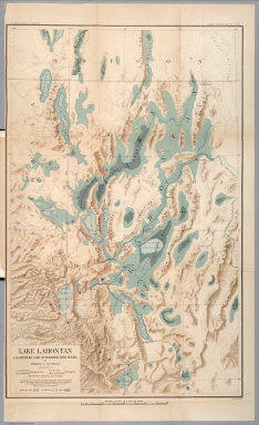
1885 Plate IV: Map of Lake Lahontan Geology Book Map of Lake Lahontan : showing water are … |

1885 Plate V: Depth of Lake Lahontan at highe … Geology Book Depth of Lake Lahontan at highest water … |

1885 Plate VI: Map showing land classificatio … Geology Book Map showing land classification of Lahon … |

1885 Plate VII: Carson Desert, Nevada Geology Book Carson Desert, Nevada. Julius Bien & Co. … |

1885 Plate VIII: Springs of the Lahontan Regi … Geology Book Springs of the Lahontan Region. Julius B … |

1885 Plate IX: Pyramid and Winnemucca Lakes, … Geology Book Pyramid and Winnemucca Lakes, Nevada. W. … |

1885 Plate X: Anaho Island, Pyramid Lake, Nev … Geology Book Anaho Island, Pyramid Lake, Nevada. W.D. … |