Who What Where WhenREMOVEWHERE
|
Author
[Berghaus, Hermann, Luddecke, Richard, Steinmann, G.]
Full Title
Sud-Amerika. (with) Vulcan Descabezado. (with) Cordillere von Copiapo nach Brackenbusch, Domeyko, Stelzner und Steinmann. (with) Durchschnitt des Westabhanges der Cordillere von Copiapo nach G. Steinmann. (with) Minen von Callao. (with) Laguna de San Rafael. (with) Sierra Nevada de Cocui. (with) Durchschnitt des Sergipe-Alagoas Beckens nach J.C. Branner. Bearb. v. G. Steinmann u. H. Berghaus, red. v. R. Luddecke. Ausgabe 1891. Gest. v. F. Geyer. Gotha: Justus Perthes (1892)
Publisher
Justus Perthes
Author
Berghaus, Hermann
Full Title
Oceanien. (with) Victoria nach Brough Smyth. (with) Tasmanien nach R.M. Johnston und C.P. Sprent. (with) Landenge von Auckland n.v. Hochstetter. (with) Das Seenland (Neu-Seeland) nach d. 10. Juni 1886. (with) Hawaii-Vulkane veranderungen bis 1886. Entw. v. H. Berghaus 1886, Ausg. 1888. Gotha: Justus Perthes (1892)
Publisher
Justus Perthes
Author
Berghaus, Hermann
Full Title
(Covers to) Atlas der Geologie. Berghaus' Physikalischer Atlas, Abteilung I. 15 kolorierte Karten in Kupferstich mit 150 Darstellungen. Unter beratender Mitwirkung von Prof. Dr. K. v. Zittel, bearbeitet von Dr. Hermann Berghaus, Professor in Gotha. Nach dem Tode des Verfassers in einigen Karten fertiggestellt von Dr. R. Luddecke, Dr. C. Rohrbach und Prof. Dr. Steinmann ... Gotha: Justus Perthes. 1892.
Publisher
Justus Perthes
Author
Berghaus, Hermann
Full Title
(Title Page to) Atlas der Geologie. Berghaus' Physikalischer Atlas, Abteilung I. 15 kolorierte Karten in Kupferstich mit 150 Darstellungen. Unter beratender Mitwirkung von Prof. Dr. K. v. Zittel, bearbeitet von Dr. Hermann Berghaus, Professor in Gotha. Nach dem Tode des Verfassers in einigen Karten fertiggestellt von Dr. R. Luddecke, Dr. C. Rohrbach und Prof. Dr. Steinmann ... Gotha: Justus Perthes. 1892.
Publisher
Justus Perthes
Author
[Stewart, John H., United States Geological Survey (USGS), Nevada Bureau of Mines and Geology, Carlson, John E.]
Full Title
Geologica Map of Nevada.
Publisher
United States Geological Survey (USGS)
Author
[Jennings, Charles W., California Division of Mines and Geology]
Full Title
Fault Map of California , w/ locations of Volcanoes, Thermal Springs, and Thermal Wells.
Publisher
Williams & Heintz Map Corp
Author
[Jennings, Charles W., Strand, R.G., Rogers, T.H.]
Full Title
Geologic Map of California.
Publisher
Charles W. Jennings
Author
[Justus Perthes, Fahlbusch, Klaus]
Full Title
Geologie der Erde - Geology of the Earth - Geologia del Mundo.
Publisher
Justus Perthes
Author
[Denoyer-Geppert Company, Westermann, Georg, Scheu, E.]
Full Title
The Structural Elements of the Earth.
Publisher
Georg Westermann
Author
[Larson, R. L., National Science Foundation, Office of Naval Research]
Full Title
The Bedrock Geology of the World.
Publisher
W. H. Freeman and Company, Inc.
Author
Newberry, John S.
Full Title
Geological map of Ohio by J.S. Newberry, Chief Geologist, 1872. (Published by Stedman, Brown & Lyon, Cincinnati. 1872. Entered ... 1872, by H.F. Walling, and O.W. Gray, and H.H. Lloyd & Co. ... Washington)
Publisher
Stedman, Brown & Lyon
Author
W. & A.K. Johnston Limited
Full Title
Earthquakes & Volcanoes over the Globe. Isobaric Lines and Prevailing Winds of the Globe for January after De Buchan.
Publisher
W. & A.K. Johnston Limited
Author
W. & A.K. Johnston Limited
Full Title
The Mountains, Table Lands, Plains & Valleys of Europe. Geological Map of Europe.
Publisher
W. & A.K. Johnston Limited
Author
W. & A.K. Johnston Limited
Full Title
The Mountains, Table Lands, Plains & Valleys of North America. Geological Map of North America.
Publisher
W. & A.K. Johnston Limited
Author
[Bishop, F. M., De Motte, B. C., Geological and Geographical Survey of the Territories (U.S.), Powell, John Wesley, 1834-1902, Thompson, A. H. (Almon Harris), 1839-1906]
Full Title
Green River from the Union Pacific Rail Road to the mouth of White River, 1873 (geology). Department of the Interior. U.S. Geological and Geographical Survey of the Territories. Second Division. J.W. Powell, geologist in charge, A.H. Thompson, geographer, B.C. De Motte & F.M. Bishop, topographers. W.H. Graves del. Outlines engraved by S.J. Kubel. U.S. G. and G. Survey, 2d. Div. ... Geology of the Unita Mountains. (Julius Bien Lith.)
Publisher
Julius Bien
Author
[Geological and Geographical Survey of the Territories (U.S.), Powell, John Wesley, 1834-1902]
Full Title
Structure sections through the Uinta Mountains. U.S. G. and G. Survey, 2d. Div., J.W. Powell, geologist in charge. Geology of the Unita Mountains. (Julius Bien Lith.)
Publisher
Julius Bien
Author
[Geological and Geographical Survey of the Territories (U.S.), Powell, John Wesley, 1834-1902]
Full Title
Displacement diagrams derived from the Structure sections through the Uinta Mountains, pl. I. U.S. G. and G. Survey, 2d. Div., J.W. Powell, geologist in charge. Geology of the Unita Mountains. (Julius Bien Lith.)
Publisher
Julius Bien
Author
[Geological and Geographical Survey of the Territories (U.S.), Powell, John Wesley, 1834-1902]
Full Title
Stereogram of the displacements of the eastern portion of the Uinta Mountains. U.S. G. and G. Survey, 2d. Div., J.W. Powell, geologist in charge. Geology of the Unita Mountains. (Julius Bien Lith.)
Publisher
Julius Bien
Author
[Geological and Geographical Survey of the Territories (U.S.), Gilbert, Grove Karl, 1843-1918, Powell, John Wesley, 1834-1902]
Full Title
Bird's-eye view of a part of the Uinta Uplift. Designed by G.K. Gilbert. U.S. G. and G. Survey, 2d. Div., J.W. Powell, geologist in charge. Geology of the Unita Mountains. (Julius Bien Lith.)
Publisher
Julius Bien
Author
[Geological and Geographical Survey of the Territories (U.S.), Powell, John Wesley, 1834-1902]
Full Title
Stereogram of the displacements of the Yampa Plateau. U.S. G. and G. Survey, 2d. Div., J.W. Powell, geologist in charge. Geology of the Unita Mountains. (Julius Bien Lith.)
Publisher
Julius Bien
Author
[Geological and Geographical Survey of the Territories (U.S.), Marvine, Archibald Robertson, 1848-1876, Powell, John Wesley, 1834-1902]
Full Title
No. 1. Structure section through the Aspen Mountain Uplift. No. 2. Displacement diagram derived from the above section. (with) Generalized structure section through the Park Mountains. By Archibald R. Marvine. U.S. G. and G. Survey, 2d. Div., J.W. Powell, geologist in charge. Geology of the Unita Mountains. (Julius Bien Lith.)
Publisher
Julius Bien
Author
[Geographical and Geological Survey of the Rocky Mountain Region (U.S.), Jenney, Walter Proctor, 1849-1921, Newton, Henry, 1845-1877]
Full Title
Bird's eye view of the Black Hills to illustrate the geological structure. Dept. of the Interior, U.S.G. and G. Survey, J.W. Powell, in charge. Geology of the Black Hills by Henry Newton, E.M. (Julius Bien, Lith. New York, 1879)
Publisher
Julius Bien
Author
[Heezen, Bruce C., Tharp, Marie]
Full Title
Physiographic Diagram, Atlantic Ocean (Sheet 1).
Author
Time Inc.
Full Title
The New Portrait of our Planet. Life.
Publisher
Time Inc.
Author
Harrison, Richard Edes
Full Title
The Floor of the World Ocean.
Publisher
Association of American Geographers
Author
[Andreas, A. T. (Alfred Theodore), 1839-1900, Baskin, Forster and Company]
Full Title
Geological map of Indiana. Climatological map of Indiana. (Published by Baskin, Forster & Co. Lakeside Building Chicago, Ills. 1876. Engraved & Printed by Chas. Shober & Co. Props. of Chicago Lithographing Co.)
Publisher
Baskin, Forster & Co.
Author
[United States Geological Survey (USGS), Goddard, Edwin]
Full Title
Geologic Map of North America.
Publisher
United States Geological Survey (USGS)
Author
[United States Geological Survey (USGS), King, Philip B.]
Full Title
Tectonic Map of North America.
Publisher
United States Geological Survey
Author
[United States Geological Survey (USGS), Bayer, Kenneth C.]
Full Title
Generalized Structural Lithographic and Physiographic Provinces in the Fold and Thrust Belts of the United States, (exclusive of Alaska and Hawaii).
Publisher
United States Geological Survey (USGS)
Author
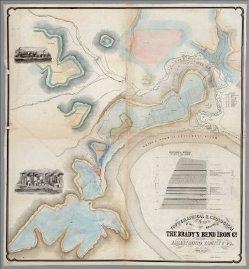
[Franks, Theo., Brady's Bend Iron Co.]
Full Title
Topographical & Geological Map Of The Property Belonging To The Brady's Bend Iron Co. Located In Armstrong County Pa. by Theo. Franks Civil Engineer. From Plan drawn by R. Jennings, Brady's Bend. Wm Schuchman, lith. 3d St, Pittsburgh, Pa. (inset) Geological Section From Notes By Prof. Shepherd.
Publisher
Wm. Schuchman lith.
Author
The Geological Society of America
Full Title
Pleistocene Eolian Deposits of the United States, Alaska and parts of Canada.
Publisher
The Geological Society of America
Author
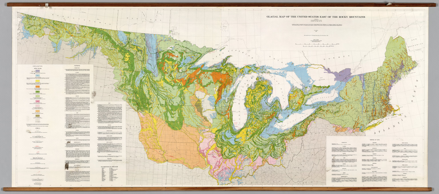
[The Geological Society of America, Flint, Richard F.]
Full Title
Glacial Map of the United States East of the Rocky Mountains.
Publisher
The Geological Society of America
Author
[Topographic and Geologic Survey, Commonwealth of PA, Williams and Heintz Map Corporation]
Full Title
Geologic Map of Pennsylvania.
Publisher
Topographic and Geologic Survey, PA
Author
[Department of Geography, University of California at Berkeley, C.O.S., D.I.E.]
Full Title
Structural Divisions.
Publisher
Manuscript
Author
[Götz, Antonín, Československá akademie věd., Czechoslovakia. Ústřední správa geodézie a kartografie.]
Full Title
Geophysics.
Publisher
Czechoslovakia. Ústřední správa geodézie a kartografie.
Author
[Götz, Antonín, Československá akademie věd., Czechoslovakia. Ústřední správa geodézie a kartografie.]
Full Title
Geology.
Publisher
Czechoslovakia. Ústřední správa geodézie a kartografie.
Author
[Götz, Antonín, Československá akademie věd., Czechoslovakia. Ústřední správa geodézie a kartografie.]
Full Title
Tectonics.
Publisher
Czechoslovakia. Ústřední správa geodézie a kartografie.
Author
[Götz, Antonín, Československá akademie věd., Czechoslovakia. Ústřední správa geodézie a kartografie.]
Full Title
Quaternary Cover and Mantle of Weathered Material.
Publisher
Czechoslovakia. Ústřední správa geodézie a kartografie.
Author
[Götz, Antonín, Československá akademie věd., Czechoslovakia. Ústřední správa geodézie a kartografie.]
Full Title
Geomorphology.
Publisher
Czechoslovakia. Ústřední správa geodézie a kartografie.
Author
[Götz, Antonín, Československá akademie věd., Czechoslovakia. Ústřední správa geodézie a kartografie.]
Full Title
Geomorphology II.
Publisher
Czechoslovakia. Ústřední správa geodézie a kartografie.
Author
[Götz, Antonín, Československá akademie věd., Czechoslovakia. Ústřední správa geodézie a kartografie.]
Full Title
Hydrology I.
Publisher
Czechoslovakia. Ústřední správa geodézie a kartografie.
Author
[Götz, Antonín, Československá akademie věd., Czechoslovakia. Ústřední správa geodézie a kartografie.]
Full Title
Hydrology II.
Publisher
Czechoslovakia. Ústřední správa geodézie a kartografie.
Author
[Götz, Antonín, Československá akademie věd., Czechoslovakia. Ústřední správa geodézie a kartografie.]
Full Title
Hydrogeology.
Publisher
Czechoslovakia. Ústřední správa geodézie a kartografie.
Author
[Colton, J.H., Parker, Nathan H.]
Full Title
(Covers to) Parker's Sectional & Geological Map Of Iowa. Exhibiting her Iron Lead Copper Coal and other Geological Resources And All Rail Roads Completed, in progress, and projected. Compiled from the U.S. Surveys and personal reconnoisance. By Nathan H. Parker. Author of "Iowa As It Is" Clinton Io. 1856. J.H. Colton & Co. 172 William St. New York. D.B. Cooke & Co. Chicago Ill. Entered ... 1856, by N.H. Parker... Iowa. Engraved, Printed And Mounted By J.H. Colton & Co. 172 William Street, New York. (inset) Map Showing the Connections between the Iowa And Eastern Rail Roads.
Publisher
[D.B. Cooke, J.H. Colton]
Author
[Colton, J.H., Parker, Nathan H.]
Full Title
Parker's Sectional & Geological Map Of Iowa. Exhibiting her Iron Lead Copper Coal and other Geological Resources And All Rail Roads Completed, in progress, and projected. Compiled from the U.S. Surveys and personal reconnoisance. By Nathan H. Parker. Author of "Iowa As It Is" Clinton Io. 1856. J.H. Colton & Co. 172 William St. New York. D.B. Cooke & Co. Chicago Ill. Entered ... 1856, by N.H. Parker... Iowa. Engraved, Printed And Mounted By J.H. Colton & Co. 172 William Street, New York. (inset) Map Showing the Connections between the Iowa And Eastern Rail Roads.
Publisher
[J.H. Colton, D.B. Cooke]
Author
[Andree, Richard, Times (London, England)]
Full Title
England and Wales Geological map. (Published at the office of "The Times," London, 1900).
Publisher
The Office of The Times
Author
[Andree, Richard, Times (London, England)]
Full Title
Scotland Geological map. (with inset) Shetland Islands. Ireland Geological map. ( (Published at the office of "The Times," London, 1900).
Publisher
The Office of The Times
Author
Mexico. Direccion de Estudios Geográficos y Climatologicos
Full Title
Carta geologica de la Republica Mexicana. Departamento de Exploraciones y Estudios Geologicos : Secretaria de Industria Comericia y Trabaja. Zincografia de la Direccion de Estadios Geograficos y Climatologicos. ( to accompany) Atlas geografico de la Republica Mexicana 1919-1921.
Publisher
Direccion de Estudion Geograficos y Climatologicos
Author
Loader, T. B.
Full Title
Under the patronage of His Majesty, T.B. Loader's scientific and commercial map of England and Wales in which are delineated the canals, rail-roads, & navigable rivers : the extent of the navigation of each river, with the elevations of the canals, together with the geology, and principal situations of the mineral productions. 1834. Published by T.B. Loader, 31 Bedford, St. Covent Garden. Mounted & colored by G. Cross, 98 Dean St. Soho.
Publisher
T.B. Loader
Author
[Ludlow, William, 1843-1901, United States. Army. Corps of Engineer]
Full Title
A geological map of the Black Hills: by Professor N.H. Winchell to accompany the report of Capt. William Ludlow U.S. Engineers. (to accompany) Report of a reconnaissance of the Black Hills of Dakota, made in the summer of 1874. By William Ludlow, Captain of Engineers, Bvt. Lieut. Colonel, U. S. Army; Chief Engineer Department of Dakota. Washington : Government Printing Office. 1875.
Publisher
Government Printing Office
|