Browse All

1966 Shorelines. Shore Drifting and Wave-cut … Physical Atlas Shorelines. Shore Drifting and Wave-cut … |

1966 Shorelines. Embayed-Resistant. Boothbay, … Physical Atlas Shorelines. Embayed-Resistant. Boothbay, … |

1966 Shorelines. Embayed-Semi-Resistant. Hull … Physical Atlas Shorelines. Embayed-Semi-Resistant. Hull … |

1966 Shorelines. Embayed-Semi-Resistant. Hull … Physical Atlas Shorelines. Embayed-Nonresistant. Tisbur … |

1966 Shorelines. Fiords and Features of Subme … Physical Atlas Shorelines. Fiords and Features of Subme … |

1966 Shorelines. Coastal Plain Shorlines-Spli … Physical Atlas Shorelines. Coastal Plain Shorlines-Spli … |

1966 Shorelines. Coastal Plain Shorlines. Ara … Physical Atlas Shorelines. Coastal Plain Shorlines. Ara … |

1966 Shorelines. Volcanic Shorelines and Reef … Physical Atlas Shorelines. Volcanic Shorelines and Reef … |

1966 Landforms Due to Wind. Coastal Dunes-Blo … Physical Atlas Landforms Due to Wind. Coastal Dunes-Blo … |

1966 Eolian Activity. Coastal Dunes-Transvers … Physical Atlas Eolian Activity. Coastal Dunes-Transvers … |

1966 Eolian Activity. Barchan Dune. Moses Lak … Physical Atlas Eolian Activity. Barchan Dune. Moses Lak … |

1966 Eolian Activity. Transverse and Paraboli … Physical Atlas Eolian Activity. Transverse and Paraboli … |

1966 Eolian Activity. Transverse Dunes. Cactu … Physical Atlas Eolian Activity. Transverse Dunes. Cactu … |

1856 Geological structure of globe. Physical Atlas The geological structure of the globe ac … |

1856 Physical Europe & Asia. Physical Atlas The physical features of Europe & Asia, … |

1856 Geological map Europe. Physical Atlas Geological map of Europe, exhibiting the … |

1854 Geological, palaeontological map British … Physical Atlas Geological & palaeontological map of the … |

1854 Palaeontological map (British Islands). Physical Atlas Palaeontological map (British Islands. B … |

1854 Composite: Geological, palaeontological … Physical Atlas (Composite of) Geological & palaeontolog … |

1856 Geol. map U.S. Physical Atlas Geological map of the United States and … |

1856 Volcanic action. Physical Atlas The phenomena of volcanic action showing … |

1856 Geological phenomena. Physical Atlas Comparative views of remarkable geologic … |

1864 Covers: Contributions to the Geology and … Exploration Book (Covers to) Contributions to the Geology … |

1864 Title Page: Contributions to the Geology … Exploration Book (Title Page to) Contributions to the Geo … |

1864 Text Page: Introduction Exploration Book (Text Page to) Introduction. (to accompa … |

1864 Text Page: (Continues) Introduction Exploration Book (Text Page to) Introduction. (to accompa … |

1864 Valley and City of Mexico Exploration Book Valley and City of Mexico. Lith. of Majo … |

1864 Popocatepetl. Iztaccihuatl Exploration Book Popocatepetl. Iztaccihuatl. Lith. of Maj … |

1864 Geological map and profiles of some of t … Exploration Book Geological map and profiles of some of t … |
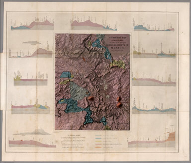
1864 Geological map and profiles of some of t … Exploration Book Geological map and profiles of some of t … |

1851 36. Geologische Landschaftsbilder Physical Atlas 36. Geologische Landschaftsbilder. Entwo … |

1851 37. Charakter-Landschaften Physical Atlas 37. Charakter-Landschaften. Entworfen vo … |

1851 38. Erdansichten der Alten. Nach Eratost … Physical Atlas 38. Erdansichten der Alten. Nach Eratost … |

1852 Distribution of Earthquakes & Volcanoes … Physical Atlas The Distribution of Earthquakes & Volcan … |

1988 Index Map: Location of Oblique Maps in A … Geologic Atlas (Index Map) Location of Oblique Maps in … |

1980 Oblique Map of the Gulf of Alaska. Geologic Atlas Oblique Map of the Gulf of Alaska. |

1972 The Aleutian-Kamchatka Convergence, Nort … Geologic Atlas The Aleutian-Kamchatka Convergence, Nort … |

1988 Central Aleutian Arc, Alaska. Geologic Atlas Central Aleutian Arc, Alaska. |

1969 Eastern Aleutian Trench and Northern Gul … Geologic Atlas Eastern Aleutian Trench and Northern Gul … |

1969 A Part of the Eastern Aleutian Trench. Geologic Atlas A Part of the Eastern Aleutian Trench. |

1981 Amlia Corridor, Alaska. Geologic Atlas Amlia Corridor, Alaska. |

1981 Barrow Canyon, Alaska. Geologic Atlas Barrow Canyon, Alaska. |

1980 Oblique Map of the Beaufort Sea and the … Geologic Atlas Oblique Map of the Beaufort Sea and the … |

1970 Bering Canyon, Aleutian Islands, Alaska. Geologic Atlas Bering Canyon, Aleutian Islands, Alaska. |

1974 Oblique Map of the Bering Sea. Geologic Atlas Oblique Map of the Bering Sea. |

1972 Northern Bering Sea. Geologic Atlas Northern Bering Sea. |

1975 Physiography Bering Sea Shelf, Alaska. Geologic Atlas Physiography Bering Sea Shelf, Alaska. |

1975 Physiography and Cross Sections Bering S … Geologic Atlas Physiography and Cross Sections Bering S … |

1975 Pre-Tertiary Rocks Bering Sea Shelf, Ala … Geologic Atlas Pre-Tertiary Rocks Bering Sea Shelf, Ala … |

1976 Pre-Tertiary Rocks Southern Bering Sea S … Geologic Atlas Pre-Tertiary Rocks Southern Bering Sea S … |