Who What Where WhenREMOVEWHEREShow More |
Author
Blum, George W.
Full Title
(Covers to) The Cyclers' Guide and Road Book of California Containing Map of California in relief with principal Roads, Seven Sectional Maps showing all available Roads for Cyclers from Chico to San Diego, and a Map of Golden Gate Park. 1896. Price, One Dollar. Compiled and Published by Geo. W. Blum, 330 Pine St., S.F. Edward Denny & Co., Agents. (on verso) Copyrighted 1895 By Geo. W. Blum, San Francisco, Cal.
Publisher
Geo. W. Blum
Author
Blum, George W.
Full Title
(Title Page to) The Cyclers' Guide and Road Book of California Containing Map of California in relief with principal Roads, Seven Sectional Maps showing all available Roads for Cyclers from Chico to San Diego, and a Map of Golden Gate Park. 1896. Price, One Dollar. Compiled and Published by Geo. W. Blum, 330 Pine St., S.F. Edward Denny & Co., Agents. (on verso) Copyrighted 1895 By Geo. W. Blum, San Francisco, Cal.
Publisher
Geo. W. Blum
Author
Blum, George W.
Full Title
Map of the Golden Gate Park, the Avenue and Buena Vista Park. 1895.
Publisher
Geo. W. Blum
Author
Blum, George W.
Full Title
Untitled map of Sonoma, Marin, Lake, and Napa Counties.
Publisher
Geo. W. Blum
Author
Blum, George W.
Full Title
(Untitled map of the South Bay including San Mateo, Santa Cruz, Santa Clara, Alameda, and Contra Costa Counties.)
Publisher
Geo. W. Blum
Author
Blum, George W.
Full Title
(Untitled map of the area around Sacramento and Marysville including Colusa, Yolo, Napa, Butte, Yuba, Sutter, Solano, and Sacramento Counties.)
Publisher
Geo. W. Blum
Author
Blum, George W.
Full Title
(Untitled map of the Central Coast area including San Benito, Fresno, Monterey, San Luis Obispo, Kings, Kern, and Santa Barbara Counties.)
Publisher
Geo. W. Blum
Author
Blum, George W.
Full Title
(Untitled map of the Central Valley area including Sacramento, Amador, Calaveras, San Joaquin, Tuolumne, Stanislaus, Merced, and Mariposa Counties.)
Publisher
Geo. W. Blum
Author
Blum, George W.
Full Title
(Untitled map of Southern California including Ventura, Los Angeles, San Bernardino, Orange, and San Diego Counties.)
Publisher
Geo. W. Blum
Author
Blum, George W.
Full Title
Map of California Roads for Cyclers. This Map Engraved by the California Photo-Eng. Co. Wasp B'ld'g., 513 Market St., S.F. Designed & Drawn by Geo. W. Blum. Edward Denny & Co. 207 Montgomery St. Sole Agents. Published and Copyrighted by Geo. W. Blum, San Francisco, Cal. (with) Inset map of the Los Angeles area.
Publisher
Geo. W. Blum
Author
[Mitchell, Samuel Augustus, Thomas, Cowperthwait & Co.]
Full Title
(Covers to) Geographical Description Of The State Of Texas; Also, Of That Part Of The West Coast Of North America, Which Includes Oregon, And Upper California. With Maps. Philadelphia: Thomas, Cowperthwait & Co. 1846. (on verso) Entered ... 1846, by Thomas, Cowperthwait & Co. ... Pennsylvania. (with) Map Of That Part Of The West Coast Of North America Comprising Oregon And Upper California. (with) Map Of The State Of Texas With Portions Of The Adjoining Regions.
Publisher
Thomas, Cowperthwait & Co.
Author
[Mitchell, Samuel Augustus, Thomas, Cowperthwait & Co.]
Full Title
Geographical Description Of The State Of Texas; Also, Of That Part Of The West Coast Of North America, Which Includes Oregon, And Upper California. With Maps. Philadelphia: Thomas, Cowperthwait & Co. 1846. (on verso) Entered ... 1846, by Thomas, Cowperthwait & Co. ... Pennsylvania. (with) Map Of That Part Of The West Coast Of North America Comprising Oregon And Upper California. (with) Map Of The State Of Texas With Portions Of The Adjoining Regions.
Publisher
Thomas, Cowperthwait & Co.
Author
Clason Map Company
Full Title
(Covers to) Nevada And The Southeastern Portion Of California. Third Edition 1907. The Clason Map Company. Publishers Of Advertising And Reference Maps Denver, Colorado. Copyrighted 1906 And 1907 By Geo. S. Clason, Denver, Colorado.
Publisher
Clason Map Company
Author
Clason Map Company
Full Title
(Title Page to) Nevada And The Southeastern Portion Of California. Third Edition 1907. The Clason Map Company. Publishers Of Advertising And Reference Maps Denver, Colorado. Copyrighted 1906 And 1907 By Geo. S. Clason, Denver, Colorado.
Publisher
Clason Map Company
Author
Clason Map Company
Full Title
Nevada And The Southeastern Portion Of California. Third Edition 1907. The Clason Map Company. Publishers Of Advertising And Reference Maps Denver, Colorado. Copyrighted 1906 And 1907 By Geo. S. Clason, Denver, Colorado.
Publisher
Clason Map Company
Author
Clason Map Company
Full Title
(Covers to) Clason's Guide Map Of The State Of Utah. Published By The Clason Map Co. Denver Colo. Copyrighted 1915, By The Clason Map Co. Denver, Colo. 1916 Edition.
Publisher
Clason Map Company
Author
Clason Map Company
Full Title
(Title Page to) Clason's Guide Map Of The State Of Utah. Published By The Clason Map Co. Denver Colo. Copyrighted 1915, By The Clason Map Co. Denver, Colo. 1916 Edition.
Publisher
Clason Map Company
Author
Clason Map Company
Full Title
Clason's Guide Map Of The State Of Utah. Published By The Clason Map Co. Denver Colo. Copyrighted 1915, By The Clason Map Co. Denver, Colo. 1916 Edition.
Publisher
Clason Map Company
Author
Clason Map Company
Full Title
(Covers to) Clason's Guide Map Of New Mexico. Published By The Clason Map Co. Denver, Colorado. Copyrighted 1915 by The Clason Map Co. Denver, Colo. 1916 Edition.
Publisher
Clason Map Company
Author
Clason Map Company
Full Title
(Title Page to) Clason's Guide Map Of New Mexico. Published By The Clason Map Co. Denver, Colorado. Copyrighted 1915 by The Clason Map Co. Denver, Colo. 1916 Edition.
Publisher
Clason Map Company
Author
Clason Map Company
Full Title
Clason's Guide Map Of New Mexico. Published By The Clason Map Co. Denver, Colorado. Copyrighted 1915 by The Clason Map Co. Denver, Colo. 1916 Edition.
Publisher
Clason Map Company
Author
Blanchard, Rufus
Full Title
(Covers to) Blanchard's Map Of The North Western States. Showing the Counties, Towns, Railroads, Stations, Steam Boat Landing etc. Compiled From The Most Authentic Sources. Published by Rufus Blanchard, 148 Lake Street, Chicago, Ill. 1868. Lith. Chas. Shober & Co. Chicago. Entered ... 1865, by R. Blanchard ... Illinois.
Publisher
Rufus Blanchard
Author
Blanchard, Rufus
Full Title
Blanchard's Map Of The North Western States. Showing the Counties, Towns, Railroads, Stations, Steam Boat Landing etc. Compiled From The Most Authentic Sources. Published by Rufus Blanchard, 148 Lake Street, Chicago, Ill. 1868. Lith. Chas. Shober & Co. Chicago. Entered ... 1865, by R. Blanchard ... Illinois.
Publisher
Rufus Blanchard
Author
Clason Map Company
Full Title
(Covers to) Clason's Guide Map Of Wyoming. Published By The Clason Map Co. Denver, Colo. Copyrighted 1917 By The Clason Map Co. Denver, Colo.
Publisher
Clason Map Company
Author
Clason Map Company
Full Title
(Title Page to) Clason's Guide Map Of Wyoming. Published By The Clason Map Co. Denver, Colo. Copyrighted 1917 By The Clason Map Co. Denver, Colo.
Publisher
Clason Map Company
Author
Clason Map Company
Full Title
Clason's Guide Map Of Wyoming. Published By The Clason Map Co. Denver, Colo. Copyrighted 1917 By The Clason Map Co. Denver, Colo.
Publisher
Clason Map Company
Author
Colton, J. H.
Full Title
(Covers to) Guide For The Territory Of Iowa, With A Correct Map, Showing the Township Surveys, &c. &c. New-York: Published By J.H. Colton 1840. (with) Map of the Surveyed part of Iowa. New York, Published by J.H. Colton, 1840. Engraved & Printed by Stiles, Sherman & Smith, N.Y. Entered ... 1839 by J.H. Colton ... N. York.
Publisher
J.H. Colton & Co.
Author
Colton, J. H.
Full Title
(Title Page to) Guide For The Territory Of Iowa, With A Correct Map, Showing the Township Surveys, &c. &c. New-York: Published By J.H. Colton 1840. (with) Map of the Surveyed part of Iowa. New York, Published by J.H. Colton, 1840. Engraved & Printed by Stiles, Sherman & Smith, N.Y. Entered ... 1839 by J.H. Colton ... N. York.
Publisher
J.H. Colton & Co.
Author
Colton, J. H.
Full Title
Guide For The Territory Of Iowa, With A Correct Map, Showing the Township Surveys, &c. &c. New-York: Published By J.H. Colton 1840. (with) Map of the Surveyed part of Iowa. New York, Published by J.H. Colton, 1840. Engraved & Printed by Stiles, Sherman & Smith, N.Y. Entered ... 1839 by J.H. Colton ... N. York.
Publisher
J.H. Colton & Co.
Author
[Mitchell, Samuel Augustus, Drake, Ira S.]
Full Title
(Covers to) Mitchell's New Traveller's Guide Through The United States, Containing The Principal Cities, Towns &c. ... Illustrated By An Accurate Map Of The United States. Philadelphia: Thomas, Cowperthwait & Co. 1853. (on verso) Entered ... 1848, by Thomas, Cowperthwait & Co. ... Pennsylvania. Stereotyped by J. Fagan. Printed by Smith & Peters. (with map) Mitchell's New Traveller's Guide Through The United States, Showing the Rail Roads, Canals, Stage Roads &c. ... Drawn and Engraved by Ira S. Drake. Philadelphia 1854. Published by Thomas, Cowperthwait & Co. Entered ... 1848, by Thomas, Cowperthwait, & Co. ... Pennsylvania. (with 5 inset maps).
Publisher
Thomas, Cowperthwait & Co.
Author
[Mitchell, Samuel Augustus, Drake, Ira S.]
Full Title
(Title Page to) Mitchell's New Traveller's Guide Through The United States, Containing The Principal Cities, Towns &c. ... Illustrated By An Accurate Map Of The United States. Philadelphia: Thomas, Cowperthwait & Co. 1853. (on verso) Entered ... 1848, by Thomas, Cowperthwait & Co. ... Pennsylvania. Stereotyped by J. Fagan. Printed by Smith & Peters. (with map) Mitchell's New Traveller's Guide Through The United States, Showing the Rail Roads, Canals, Stage Roads &c. ... Drawn and Engraved by Ira S. Drake. Philadelphia 1854. Published by Thomas, Cowperthwait & Co. Entered ... 1848, by Thomas, Cowperthwait, & Co. ... Pennsylvania. (with 5 inset maps).
Publisher
Thomas, Cowperthwait & Co.
Author
[Mitchell, Samuel Augustus, Drake, Ira S.]
Full Title
Mitchell's New Traveller's Guide Through The United States, Containing The Principal Cities, Towns &c. ... Illustrated By An Accurate Map Of The United States. Philadelphia: Thomas, Cowperthwait & Co. 1853. (on verso) Entered ... 1848, by Thomas, Cowperthwait & Co. ... Pennsylvania. Stereotyped by J. Fagan. Printed by Smith & Peters. (with map) Mitchell's New Traveller's Guide Through The United States, Showing the Rail Roads, Canals, Stage Roads &c. ... Drawn and Engraved by Ira S. Drake. Philadelphia 1854. Published by Thomas, Cowperthwait & Co. Entered ... 1848, by Thomas, Cowperthwait, & Co. ... Pennsylvania. (with 5 inset maps).
Publisher
Thomas, Cowperthwait & Co.
Author
[Mitchell, Samuel Augustus, Young, James H.]
Full Title
(Covers to) Mitchell's Travellers Guide Through The United States. A Map Of The Roads, Distances, Steam Boat & Canal Routes &c. By J.H. Young. Philadelphia. Published by S. Augustus Mitchell. 1833. Engraved On Steel By J.H. Young And D. Haines. Entered ... 1832, by S. Augustus Mitchell ... Pennsylvania. (with 9 inset maps). (with folded sheet) Index. Steam-boat And Canal Routes ...
Publisher
S.Augustus Mitchell
Author
[Mitchell, Samuel Augustus, Young, James H.]
Full Title
(Index to) Mitchell's Travellers Guide Through The United States. A Map Of The Roads, Distances, Steam Boat & Canal Routes &c. By J.H. Young. Philadelphia. Published by S. Augustus Mitchell. 1833. Engraved On Steel By J.H. Young And D. Haines. Entered ... 1832, by S. Augustus Mitchell ... Pennsylvania. (with 9 inset maps). (with folded sheet) Index. Steam-boat And Canal Routes ...
Publisher
S.Augustus Mitchell
Author
[Mitchell, Samuel Augustus, Young, James H.]
Full Title
Mitchell's Traveller's Guide Through The United States. A Map Of The Roads, Distances, Steam Boat & Canal Routes &c. By J.H. Young. Philadelphia. Published by S. Augustus Mitchell. 1833. Engraved On Steel By J.H. Young And D. Haines. Entered ... 1832, by S. Augustus Mitchell ... Pennsylvania. (with 9 inset maps). (with folded sheet) Index. Steam-boat And Canal Routes ...
Publisher
S.Augustus Mitchell
Author
Kroll Map Company
Full Title
(Covers to) Kroll's Guide Map Of Puget Sound Country. Compiled & Published by Kroll Map Co. Mehlhorn Bldg. Seattle. (copyright) 1919. C. Kroll. Lithographed By Tucker, Hanford Co. Seattle.
Publisher
Kroll Map Company
Author
Kroll Map Company
Full Title
Kroll's Guide Map Of Puget Sound Country. Compiled & Published by Kroll Map Co. Mehlhorn Bldg. Seattle. (copyright) 1919. C. Kroll. Lithographed By Tucker, Hanford Co. Seattle.
Publisher
Kroll Map Company
Author
[Mitchell, Samuel Augustus, Young, James H.]
Full Title
(Covers to) Mitchell's Traveller's Guide Through The United States, Containing The Principal Cities, Towns, &c. ... Illustrated By An Accurate Map Of The United States. Philadelphia: Hinman & Dutton, No. 6 North Fifth Street. 1838. (on verso) Entered ... 1836, by Mitchell & Hinman ... Pennsylvania. Stereotyped by John Fagan ... Philadelphia. (with map) Mitchell's Travellers Guide Through The United States. A Map Of The Roads, Distances, Steam Boat & Canal Routes &c. By J.H. Young. Philadelphia. Published by S. Augustus Mitchell. 1838. Engraved On Steel By J.H. Young And D. Haines. Entered ... 1834 by S. Augustus Mitchell ... Pennsylvania. (with 9 inset maps).
Publisher
Mitchell & Hinman
Author
[Mitchell, Samuel Augustus, Young, James H.]
Full Title
(Title Page to) Mitchell's Traveller's Guide Through The United States, Containing The Principal Cities, Towns, &c. ... Illustrated By An Accurate Map Of The United States. Philadelphia: Hinman & Dutton, No. 6 North Fifth Street. 1838. (on verso) Entered ... 1836, by Mitchell & Hinman ... Pennsylvania. Stereotyped by John Fagan ... Philadelphia. (with map) Mitchell's Travellers Guide Through The United States. A Map Of The Roads, Distances, Steam Boat & Canal Routes &c. By J.H. Young. Philadelphia. Published by S. Augustus Mitchell. 1838. Engraved On Steel By J.H. Young And D. Haines. Entered ... 1834 by S. Augustus Mitchell ... Pennsylvania. (with 9 inset maps).
Publisher
Mitchell & Hinman
Author
[Mitchell, Samuel Augustus, Young, James H.]
Full Title
Mitchell's Traveller's Guide Through The United States, Containing The Principal Cities, Towns, &c. ... Illustrated By An Accurate Map Of The United States. Philadelphia: Hinman & Dutton, No. 6 North Fifth Street. 1838. (on verso) Entered ... 1836, by Mitchell & Hinman ... Pennsylvania. Stereotyped by John Fagan ... Philadelphia. (with map) Mitchell's Travellers Guide Through The United States. A Map Of The Roads, Distances, Steam Boat & Canal Routes &c. By J.H. Young. Philadelphia. Published by S. Augustus Mitchell. 1838. Engraved On Steel By J.H. Young And D. Haines. Entered ... 1834 by S. Augustus Mitchell ... Pennsylvania. (with 9 inset maps).
Publisher
Mitchell & Hinman
Author
Colton, G. Woolworth
Full Title
(Covers to) G. Woolworth Colton's New Guide Map Of The United States & Canada, With Railroads, Counties, etc. Drawn, Engraved & Published by G. Woolworth Colton 18 Beekman St. New York, Rufus Blanchard, Chicago, Ill. 1862. Entered ... 1861 by G. Woolworth Colton ... New York. (inset) Western Portion Of The United States. (inset) Plan of The Southern Portion Of Florida.
Publisher
[Rufus Blanchard, G.Woolworth Colton]
Author
Colton, G. Woolworth
Full Title
G. Woolworth Colton's New Guide Map Of The United States & Canada, With Railroads, Counties, etc. Drawn, Engraved & Published by G. Woolworth Colton 18 Beekman St. New York, Rufus Blanchard, Chicago, Ill. 1862. Entered ... 1861 by G. Woolworth Colton ... New York. (inset) Western Portion Of The United States. (inset) Plan of The Southern Portion Of Florida.
Publisher
[G.Woolworth Colton, Rufus Blanchard]
Author
Tracy, J.L.
Full Title
(Covers to) Tracy's Guide To Missouri And St. Louis: Containing ... A Colored Township Map of Missouri... A Colored Map of the City of St. Louis ... A Colored Outline Map, Showing the Railroad Connections of St. Louis and the West ... By J.L. Tracey. St. Louis: R.P. Studley Co's Steam Print, 221 North Main Street. 1871. (with) Map Of The State Of Missouri ... To illustrate Tracy's "Missouri Guide" and "Missouri Gazetteer" ... Published by The R.P. Studley Co. ... St. Louis 1871. Lith. by R.P. Studley & Co. St. Louis. (with) Map Of The City Of St. Louis For Tracy's Guide To Missouri. Drawn & Lithd. By Juls. Hutawa 313 Chestnut St. (with) Map Of The Missouri Pacific And Atlantic & Pacific Railroads, And Connections. National Railway Publication Co. Philadelphia.
Publisher
St. Louis:
Author
Tracy, J.L.
Full Title
Map Of The State Of Missouri ... To illustrate Tracy's "Missouri Guide" and "Missouri Gazetteer" ... Published by The R.P. Studley Co. ... St. Louis 1871. Lith. by R.P. Studley & Co. St. Louis. (with) Map Of The City Of St. Louis For Tracy's Guide To Missouri. Drawn & Lithd. By Juls. Hutawa 313 Chestnut St. (with) Map Of The Missouri Pacific And Atlantic & Pacific Railroads, And Connections. National Railway Publication Co. Philadelphia.
Publisher
St. Louis:
Author
Tracy, J.L.
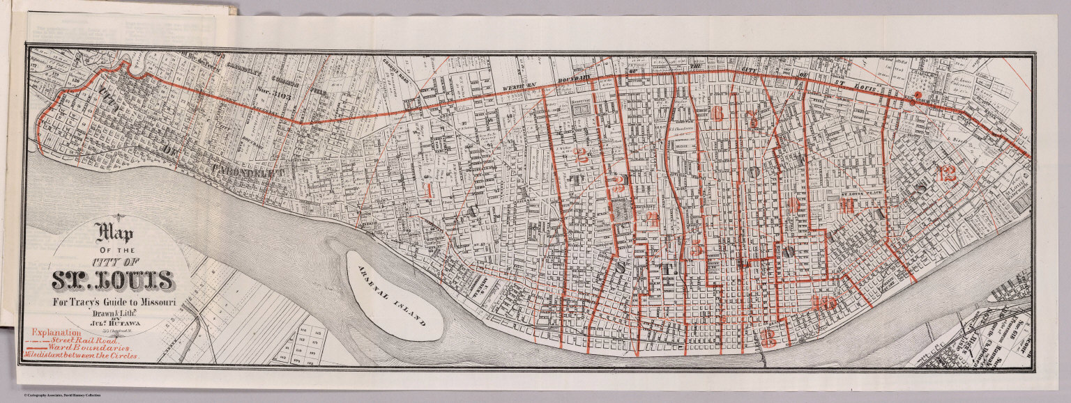
Full Title
Map Of The City Of St. Louis For Tracy's Guide To Missouri. Drawn & Lithd. By Juls. Hutawa 313 Chestnut St. (with) Map Of The State Of Missouri ... To illustrate Tracy's "Missouri Guide" and "Missouri Gazetteer" ... Published by The R.P. Studley Co. ... St. Louis 1871. Lith. by R.P. Studley & Co. St. Louis. (with) Map Of The Missouri Pacific And Atlantic & Pacific Railroads, And Connections. National Railway Publication Co. Philadelphia.
Publisher
St. Louis:
Author
Tracy, J.L.
Full Title
Map Of The Missouri Pacific And Atlantic & Pacific Railroads, And Connections. National Railway Publication Co. Philadelphia. (with) Map Of The City Of St. Louis For Tracy's Guide To Missouri. Drawn & Lithd. By Juls. Hutawa 313 Chestnut St. (with) Map Of The State Of Missouri ... To illustrate Tracy's "Missouri Guide" and "Missouri Gazetteer" ... Published by The R.P. Studley Co. ... St. Louis 1871. Lith. by R.P. Studley & Co. St. Louis.
Publisher
St. Louis:
Author
[Mitchell, Samuel Augustus, Young, James H.]
Full Title
(Covers to) Mitchell's Traveller's Guide Through The United States. A Map Of The Roads, Distances, Steam Boat & Canal Routes &c. By J.H. Young. Philadelphia. Published by S. Augustus Mitchell. 1835. Engraved On Steel By J.H. Young And D. Haines. Entered ... 1834 by S. Augustus Mitchell ... Pennsylvania. (with 9 inset maps). (with folded sheet) Index. Steam-boat And Canal Routes ...
Publisher
S.Augustus Mitchell
Author
[Mitchell, Samuel Augustus, Young, James H.]
Full Title
(Index to) Mitchell's Traveller's Guide Through The United States. A Map Of The Roads, Distances, Steam Boat & Canal Routes &c. By J.H. Young. Philadelphia. Published by S. Augustus Mitchell. 1835. Engraved On Steel By J.H. Young And D. Haines. Entered ... 1834 by S. Augustus Mitchell ... Pennsylvania. (with 9 inset maps). (with folded sheet) Index. Steam-boat And Canal Routes ...
Publisher
S.Augustus Mitchell
Author
[Mitchell, Samuel Augustus, Young, James H.]
Full Title
Mitchell's Traveller's Guide Through The United States. A Map Of The Roads, Distances, Steam Boat & Canal Routes &c. By J.H. Young. Philadelphia. Published by S. Augustus Mitchell. 1835. Engraved On Steel By J.H. Young And D. Haines. Entered ... 1834 by S. Augustus Mitchell ... Pennsylvania. (with 9 inset maps). (with folded sheet) Index. Steam-boat And Canal Routes ...
Publisher
S.Augustus Mitchell
Author
Clason Map Company
Full Title
(Covers to) Clason's Map Of California Published By The Clason Map Co., Denver, Colo. Copyrighted 1910 By The Clason Map Co., Denver, Col. (inset) Enlarged Section Of San Francisco And Vicinity. (inset) Enlarged Section Of Los Angeles And Vicinity.
Publisher
Clason Map Company
|