Who What Where WhenREMOVEWHERE
WHO |
Author
[Paullin, Charles O., Wright, John K.]
Full Title
(Covers to) Atlas of the Historical Geography of the United States. By Charles O. Paullin, Carnegie Institution of Washington. Edited by John K. Wright, Librarian, American Geographical Society of New York. Published Jointly by Carnegie Institution of Washington and the American Geographical Society of New York, 1932.
Publisher
[Carnegie Institution of Washington, American Geographical Society of New York]
Author
[Paullin, Charles O., Wright, John K.]
Full Title
(Title Page) Atlas of the Historical Geography of the United States. By Charles O. Paullin, Carnegie Institution of Washington. Edited by John K. Wright, Librarian, American Geographical Society of New York. Published Jointly by Carnegie Institution of Washington and the American Geographical Society of New York, 1932.
Publisher
[Carnegie Institution of Washington, American Geographical Society of New York]
Author
[Paullin, Charles O., Wright, John K.]
Full Title
(Composite Text of) (Preface, Introduction, Main Text).
Publisher
[Carnegie Institution of Washington, American Geographical Society of New York]
Author
[Paullin, Charles O., Wright, John K.]
Full Title
Plate 1. Natural Environment: Natural Regions, Glaciated Areas, Ocean Currents. Major Geographical Regions. Cultivated Crops. Winds and Sailing Routes - Winter. Winds and Sailing Routes - Summer.
Publisher
[Carnegie Institution of Washington, American Geographical Society of New York]
Author
[Paullin, Charles O., Wright, John K.]
Full Title
Plate 2. Physical Geography and Vegetation. Relief; Soil Regions. Physical Divisions. Vegetation Regions.
Publisher
[Carnegie Institution of Washington, American Geographical Society of New York]
Author
[Paullin, Charles O., Wright, John K.]
Full Title
Plate 3. Forests; Growing Season. Area of Virgin Forest 1620. Area of Virgin Forest 1850. Area of Virgin Forest 1926. National Forest 1930. Average Length of Growing Season.
Publisher
[Carnegie Institution of Washington, American Geographical Society of New York]
Author
[Paullin, Charles O., Wright, John K.]
Full Title
Plate 4. Climate. Snow Cover. Droughts. Relative Humidity. Cloudiness. Pressure.
Publisher
[Carnegie Institution of Washington, American Geographical Society of New York]
Author
[Paullin, Charles O., Wright, John K.]
Full Title
Plate 5. Climate. Temperature. Rainfall.
Publisher
[Carnegie Institution of Washington, American Geographical Society of New York]
Author
[Paullin, Charles O., Wright, John K.]
Full Title
Plate 6. Mineral Resources. Coal Fields, Distribution and Production of Iron Ore.
Publisher
[Carnegie Institution of Washington, American Geographical Society of New York]
Author
[Paullin, Charles O., Wright, John K.]
Full Title
Plate 7. Mineral Resources. Oil and Gas Fields. Gold, Silver, and Copper Districts.
Publisher
[Carnegie Institution of Washington, American Geographical Society of New York]
Author
[Paullin, Charles O., Wright, John K.]
Full Title
Plate 45. Lands. Grants of Western Lands by Georgia to Land Companies, 1789. 1875. Military Reserves, 1778 - 1816.
Publisher
[Carnegie Institution of Washington, American Geographical Society of New York]
Author
[Paullin, Charles O., Wright, John K.]
Full Title
Plate 46. Lands. British Possessions after the Quebec Act, 1774. Proposed States According to Ordinance of 1784. Territorial Acquisitions 1783-1853.
Publisher
[Carnegie Institution of Washington, American Geographical Society of New York]
Author
[Paullin, Charles O., Wright, John K.]
Full Title
Plate 47. Lands. Indian Cessions 1750-1890. Claims and Cessions of Western Lands, 1776-1803 Connecticut and South Carolina. Claims and Cessions of Western Lands, 1776-1802, New York. Claims and Cessions of Western Lands, 1776-1802, Virginia and Georgia. Claims and Cessions of Western Lands, 1776-1802, Massachusetts and North Carolina.
Publisher
[Carnegie Institution of Washington, American Geographical Society of New York]
Author
[Paullin, Charles O., Wright, John K.]
Full Title
Plate 54. Lands. A Modern City, Springfield, Illinois, 1915 (Facsimile).
Publisher
[Carnegie Institution of Washington, American Geographical Society of New York]
Author
[Paullin, Charles O., Wright, John K.]
Full Title
Plate 56. Lands. A Western Town: Carroll, Nebraska, 1918. A Western Township Pilot Knob, Harper County, Kansas, 1919. Specimen Private Land Claims, 1835. Federal Land Grants for the Construction of Railroads and Wagon Roads, 1823-1871. Oil Land Withdrawals in California, 1915 (Facsimiles).
Publisher
[Carnegie Institution of Washington, American Geographical Society of New York]
Author
[Paullin, Charles O., Wright, John K.]
Full Title
Plate 57. Public Lands. Public Lands of United States, 1790. Public Lands of United States, 1810.
Publisher
[Carnegie Institution of Washington, American Geographical Society of New York]
Author
[Paullin, Charles O., Wright, John K.]
Full Title
Plate 58. Public Lands. Public Lands of United States, 1830. Public Lands of United States, 1850. Public Lands of United States, 1870. Public Lands of United States, 1890.
Publisher
[Carnegie Institution of Washington, American Geographical Society of New York]
Author
[Paullin, Charles O., Wright, John K.]
Full Title
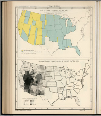
Plate 59. Public Lands. Public Lands of United States, 1910. Distribution of Public Lands of United States, 1929.
Publisher
[Carnegie Institution of Washington, American Geographical Society of New York]
Author
[Paullin, Charles O., Wright, John K.]
Full Title
Plate 60. Settlement and Population, 1660-1790. Settled Areas and Population, 1660. Settled Areas and Population, 1770. Settled Areas, 1760, and Population, 1750. Settled Areas and Population, 1775. Settled Areas and Population, 1790.
Publisher
[Carnegie Institution of Washington, American Geographical Society of New York]
Author
[Paullin, Charles O., Wright, John K.]
Full Title
Plate 61. Colonial Towns, States, Territories, and Cities. Colonial Towns, 1650. Colonial Towns, 1700. Colonial Towns, 1750. Colonial Towns, 1775. States, Territories and Cities, 1790. States, Territories and Cities, 1800. States, Territories and Cities, 1810.
Publisher
[Carnegie Institution of Washington, American Geographical Society of New York]
Author
[Paullin, Charles O., Wright, John K.]
Full Title
Plate 62. States, Territories and Cities. States, Territories and Cities, 1820. States, Territories and Cities, 1830.
Publisher
[Carnegie Institution of Washington, American Geographical Society of New York]
Author
[Paullin, Charles O., Wright, John K.]
Full Title
Plate 63. States, Territories and Cities. States, Territories and Cities, 1840. States, Territories and Cities, 1850.
Publisher
[Carnegie Institution of Washington, American Geographical Society of New York]
Author
[Paullin, Charles O., Wright, John K.]
Full Title
Plate 64. States, Territories and Cities. States, Territories and Cities, 1860. States, Territories and Cities, 1870. States and Territories (Additional Maps 1845-1868). States, Territories and Cities, 1880.
Publisher
[Carnegie Institution of Washington, American Geographical Society of New York]
Author
[Paullin, Charles O., Wright, John K.]
Full Title
Plate 65. States, Territories and Cities. States, Territories and Cities, 1890. States, Territories and Cities, 1900.
Publisher
[Carnegie Institution of Washington, American Geographical Society of New York]
Author
[Paullin, Charles O., Wright, John K.]
Full Title
Plate 66. States, Territories and Cities. States, Territories and Cities, 1910. States, Territories and Cities, 1920.
Publisher
[Carnegie Institution of Washington, American Geographical Society of New York]
Author
[Paullin, Charles O., Wright, John K.]
Full Title
Plate 67. States and Cities: Population. States and Cities, 1930. Slaves, 1790. Slaves, 1800. Slaves, 1810. Slaves, 1820. Slaves, 1830. Slaves, 1840.
Publisher
[Carnegie Institution of Washington, American Geographical Society of New York]
Author
[Paullin, Charles O., Wright, John K.]
Full Title
Plate 68. Population. Slaves, 1850. Slaves, 1860. Free Negroes, 1810.
Publisher
[Carnegie Institution of Washington, American Geographical Society of New York]
Author
[Paullin, Charles O., Wright, John K.]
Full Title
Plate 69. Population. Free Negroes, 1860. Colored Population, 1880.
Publisher
[Carnegie Institution of Washington, American Geographical Society of New York]
Author
[Paullin, Charles O., Wright, John K.]
Full Title
Plate 70. Population: Emigration to the United States. Colored Population, 1900. Colored Population, 1930. Sources of Emigration to the United States (by decade),
Publisher
[Carnegie Institution of Washington, American Geographical Society of New York]
Author
[Paullin, Charles O., Wright, John K.]
Full Title
Plate 71. Population. Foreign-Born Population, 1860. Foreign-Born Population, 1880.
Publisher
[Carnegie Institution of Washington, American Geographical Society of New York]
Author
[Paullin, Charles O., Wright, John K.]
Full Title
Plate 72. Population. Foreign-Born Population, 1900. Foreign-Born White Population, 1930.
Publisher
[Carnegie Institution of Washington, American Geographical Society of New York]
Author
[Paullin, Charles O., Wright, John K.]
Full Title
Plate 73. Population. Foreign-Born Population, German, 1880. Foreign-Born Population, German, 1900. Foreign-Born Population, German, 1930. Foreign-Born Population, Irish, 1880.
Publisher
[Carnegie Institution of Washington, American Geographical Society of New York]
Author
[Paullin, Charles O., Wright, John K.]
Full Title
Plate 74. Population. Foreign-Born Population, Irish, 1900. Foreign-Born Population, Irish, 1930.
Publisher
[Carnegie Institution of Washington, American Geographical Society of New York]
Author
[Paullin, Charles O., Wright, John K.]
Full Title
Plate 75. Population. Foreign-Born Population, Swedish and Norwegian, 1880. Foreign-Born Population, Swedish and Norwegian, 1900.
Publisher
[Carnegie Institution of Washington, American Geographical Society of New York]
Author
[Paullin, Charles O., Wright, John K.]
Full Title
Plate 76. Population. Foreign-Born Population, Swedish and Norwegian, 1790. Density of Population, 1800. Density of Population, 1810. Density of Population, 1820. Density of Population, 1830. Density of Population, 1840.
Publisher
[Carnegie Institution of Washington, American Geographical Society of New York]
Author
[Paullin, Charles O., Wright, John K.]
Full Title
Plate 77. Population. Density of Population, 1850. Density of Population, 1860. Density of Population, 1870.
Publisher
[Carnegie Institution of Washington, American Geographical Society of New York]
Author
[Paullin, Charles O., Wright, John K.]
Full Title
Plate 78. Population. Density of Population, 1880. Density of Population, 1890.
Publisher
[Carnegie Institution of Washington, American Geographical Society of New York]
Author
[Paullin, Charles O., Wright, John K.]
Full Title
Plate 79. Density of Population. Density of Population, 1900. Density of Population, 1910. Density of Population, 1920. Density of Population, 1930.
Publisher
[Carnegie Institution of Washington, American Geographical Society of New York]
Author
[Paullin, Charles O., Wright, John K.]
Full Title
Plate 80. Population: Colleges and Universities. Centers of Population. Colleges and Universities, 1775. Colleges and Universities, 1800. Colleges and Universities, 1830.
Publisher
[Carnegie Institution of Washington, American Geographical Society of New York]
Author
[Paullin, Charles O., Wright, John K.]
Full Title
Plate 81. Colleges and Universities. Colleges and Universities, 1860. Colleges and Universities, 1890.
Publisher
[Carnegie Institution of Washington, American Geographical Society of New York]
Author
[Paullin, Charles O., Wright, John K.]
Full Title
Plate 82. Churches. Congregationalist, 1775-1776. Presbyterian, 1775-1776. Protestant-Episcopal, 1775-1776. Baptist, 1775-1776. Friends, 1775-1776. German Reformed, 1776-1776. Lutheran, 1775-1776. Dutch Reformed, 1775-1776. Methodist, 1775-1776. Catholic, 1775-1776. Minor Denominations, 1775-1776. Minor Denominations, 1775-1776.
Publisher
[Carnegie Institution of Washington, American Geographical Society of New York]
Author
[Paullin, Charles O., Wright, John K.]
Full Title
Plate 83. Churches. Methodist, 1860. Baptist, 1860.
Publisher
[Carnegie Institution of Washington, American Geographical Society of New York]
Author
[Paullin, Charles O., Wright, John K.]
Full Title
Plate 84. Churches. Congregational, 1860. Protestant-Episcopal, 1860. Lutheran, 1860. "Christian," 1860. Reformed, 1860. Friends, 1860. Presbyterian, 1860.
Publisher
[Carnegie Institution of Washington, American Geographical Society of New York]
Author
[Paullin, Charles O., Wright, John K.]
Full Title
Plate 85. Churches. Catholic, 1860. Methodist, 1890.
Publisher
[Carnegie Institution of Washington, American Geographical Society of New York]
Author
[Paullin, Charles O., Wright, John K.]
Full Title
Plate 86. Churches. Baptist, 1890. Presbyterian, 1890.
Publisher
[Carnegie Institution of Washington, American Geographical Society of New York]
Author
[Paullin, Charles O., Wright, John K.]
Full Title
Plate 87. Churches. Catholic, 1890. Congregational, 1890. Protestant - Episcopal, 1890. Lutheran, 1890.
Publisher
[Carnegie Institution of Washington, American Geographical Society of New York]
Author
[Paullin, Charles O., Wright, John K.]
Full Title
Plate 88. Churches. Disciples of Christ, 1890. Reformed, 1890.
Publisher
[Carnegie Institution of Washington, American Geographical Society of New York]
Author
[Paullin, Charles O., Wright, John K.]
Full Title
Plate 89. Negotiation for Peace, 1779 - 1783. Negotiations for Peace (Base, Mitchell's Map of North America, 1755, second edition reduced size).
Publisher
[Carnegie Institution of Washington, American Geographical Society of New York]
Author
[Paullin, Charles O., Wright, John K.]
Full Title
Plate 90. Negotiation for Peace, 1779 - 1783. Negotiations for Peace (Northeast Section) (Base, Mitchell's Map of North America, 1755, second edition, reduced size).
Publisher
[Carnegie Institution of Washington, American Geographical Society of New York]
Author
[Paullin, Charles O., Wright, John K.]
Full Title
Plate 91. International Boundary Disputes. The Northwest Angle of Nova Scotia and the Highlands. Isle Royal to Lake of the Woods. St. Croix River.
Publisher
[Carnegie Institution of Washington, American Geographical Society of New York]
|