Who What Where WhenREMOVE |
Author
[Mast, Crowell & Kirkpatrick, Hannaford, Lieut. E.]
Full Title
(Covers to) Map Of Cuba. Its Provinces, Railroads, Cities, Towns, Harbors, Bays, Etc. Also Southern Florida And Neighboring Islands Of The West Indies. Price, by Mail, Postpaid, 25 Cents. Published By Mast, Crowell, Kirkpatrick, New York and Chicago. Copyright, 1897, by Mast, Crowell & Kirkpatrick. (with history book) Map And History Of Cuba From The Latest And Best Authorities, Including a Clear and Graphic Account of the War of 1895-1897. By Lieut. E. Hannaford. Copyright, 1897, by Mast, Crowell & Kirkpatrick. Published By Mast, Crowell & Kirkpatrick, Springfield, Ohio, 1897.
Publisher
Mast, Crowell & Kirkpatrick
Author
[Mast, Crowell & Kirkpatrick, Hannaford, Lieut. E.]
Full Title
(Title Page to) Map Of Cuba. Its Provinces, Railroads, Cities, Towns, Harbors, Bays, Etc. Also Southern Florida And Neighboring Islands Of The West Indies. Price, by Mail, Postpaid, 25 Cents. Published By Mast, Crowell, Kirkpatrick, New York and Chicago. Copyright, 1897, by Mast, Crowell & Kirkpatrick. (with history book) Map And History Of Cuba From The Latest And Best Authorities, Including a Clear and Graphic Account of the War of 1895-1897. By Lieut. E. Hannaford. Copyright, 1897, by Mast, Crowell & Kirkpatrick. Published By Mast, Crowell & Kirkpatrick, Springfield, Ohio, 1897.
Publisher
Mast, Crowell & Kirkpatrick
Author
[Mast, Crowell & Kirkpatrick, Hannaford, Lieut. E.]
Full Title
Map Of Cuba. Its Provinces, Railroads, Cities, Towns, Harbors, Bays, Etc. Also Southern Florida And Neighboring Islands Of The West Indies. Price, by Mail, Postpaid, 25 Cents. Published By Mast, Crowell, Kirkpatrick, New York and Chicago. Copyright, 1897, by Mast, Crowell & Kirkpatrick. (with history book) Map And History Of Cuba From The Latest And Best Authorities, Including a Clear and Graphic Account of the War of 1895-1897. By Lieut. E. Hannaford. Copyright, 1897, by Mast, Crowell & Kirkpatrick. Published By Mast, Crowell & Kirkpatrick, Springfield, Ohio, 1897.
Publisher
Mast, Crowell & Kirkpatrick
Author
Venezuela-British Guiana Boundary Commission
Full Title
Drainage Basin. 3. S Doc 91 55 2. The Orinoco - Essequibo Region, South America, Compiled under the Direction of the Commission Appointed "To Investigate and Report upon the True Divisional Line between the Republic of Venezuela and British Guiana." Washington D.C. 1897. Lith. by A. Hoen & Co., Baltimore, MD.
Publisher
United States of America
Author
Venezuela-British Guiana Boundary Commission
Full Title
Geology. 4. S Doc 91 55 2. Geological Map. The Orinoco - Essequibo Region, South America, Compiled under the Direction of the Commission Appointed "To Investigate and Report upon the True Divisional Line between the Republic of Venezuela and British Guiana." Washington D.C. 1897. Lith. by A. Hoen & Co., Baltimore, MD.
Publisher
United States of America
Author
Venezuela-British Guiana Boundary Commission
Full Title
1597. 5. S Doc 91 55 2. Historical Map Showing European Occupation in the year 1597. The Orinoco - Essequibo Region, South America, Compiled under the Direction of the Commission Appointed "To Investigate and Report upon the True Divisional Line between the Republic of Venezuela and British Guiana." Washington D.C. 1897. Lith. by A. Hoen & Co., Baltimore, MD.
Publisher
United States of America
Author
Venezuela-British Guiana Boundary Commission
Full Title
1626. 6. S Doc 91 55 2. Historical Map Showing European Occupation in the Year 1626. The Orinoco - Essequibo Region, South America, Compiled under the Direction of the Commission Appointed "To Investigate and Report upon the True Divisional Line between the Republic of Venezuela and British Guiana." Washington D.C. 1897. Lith. by A. Hoen & Co., Baltimore, MD.
Publisher
United States of America
Author
Venezuela-British Guiana Boundary Commission
Full Title
1648. 7. S Doc 91 55 2. Historical Map Showing European Occupation in the Year 1648. The Orinoco - Essequibo Region, South America, Compiled under the Direction of the Commission Appointed "To Investigate and Report upon the True Divisional Line between the Republic of Venezuela and British Guiana." Washington D.C. 1897. Lith. by A. Hoen & Co., Baltimore, MD.
Publisher
United States of America
Author
Venezuela-British Guiana Boundary Commission
Full Title
1674. 8. S Doc 91 55 2. Historical Map Showing European Occupation in the Year 1674. The Orinoco - Essequibo Region, South America, Compiled under the Direction of the Commission Appointed "To Investigate and Report upon the True Divisional Line between the Republic of Venezuela and British Guiana." Washington D.C. 1897. Lith. by A. Hoen & Co., Baltimore, MD.
Publisher
United States of America
Author
Venezuela-British Guiana Boundary Commission
Full Title
1703. 9. S Doc 91 55 2. Historical Map Showing European Occupation in the Year 1703. The Orinoco - Essequibo Region, South America, Compiled under the Direction of the Commission Appointed "To Investigate and Report upon the True Divisional Line between the Republic of Venezuela and British Guiana." Washington D.C. 1897. Lith. by A. Hoen & Co., Baltimore, MD.
Publisher
United States of America
Author
Venezuela-British Guiana Boundary Commission
Full Title
1724. 10. S Doc 91 55 2. Historical Map Showing European Occupation in the Year 1724. The Orinoco - Essequibo Region, South America, Compiled under the Direction of the Commission Appointed "To Investigate and Report upon the True Divisional Line between the Republic of Venezuela and British Guiana." Washington D.C. 1897. Lith. by A. Hoen & Co., Baltimore, MD.
Publisher
United States of America
Author
Venezuela-British Guiana Boundary Commission
Full Title
1756. 11. S Doc 91 55 2. Historical Map Showing European Occupation in the Year 1756. The Orinoco - Essequibo Region, South America, Compiled under the Direction of the Commission Appointed "To Investigate and Report upon the True Divisional Line between the Republic of Venezuela and British Guiana." Washington D.C. 1897. Lith. by A. Hoen & Co., Baltimore, MD.
Publisher
United States of America
Author
Venezuela-British Guiana Boundary Commission
Full Title
1772. 12. S Doc 91 55 2. Historical Map Showing European Occupation in the Year 1772. The Orinoco - Essequibo Region, South America, Compiled under the Direction of the Commission Appointed "To Investigate and Report upon the True Divisional Line between the Republic of Venezuela and British Guiana." Washington D.C. 1897. Lith. by A. Hoen & Co., Baltimore, MD.
Publisher
United States of America
Author
Venezuela-British Guiana Boundary Commission
Full Title
1796. 13. S Doc 91 55 2. Historical Map Showing European Occupation in the Year 1796. The Orinoco - Essequibo Region, South America, Compiled under the Direction of the Commission Appointed "To Investigate and Report upon the True Divisional Line between the Republic of Venezuela and British Guiana." Washington D.C. 1897. Lith. by A. Hoen & Co., Baltimore, MD.
Publisher
United States of America
Author
Venezuela-British Guiana Boundary Commission
Full Title
1803 (1814). 14. S Doc 91 55 2. Historical Map Showing European Occupation in the Year 1803. (The Date when Essequibo - Restored to the Dutch in 1802 - Passed Finally into British Hands, though not Ceded until 1814.). The Orinoco - Essequibo Region, South America, Compiled under the Direction of the Commission Appointed "To Investigate and Report upon the True Divisional Line between the Republic of Venezuela and British Guiana." Washington D.C. 1897. Lith. by A. Hoen & Co., Baltimore, MD.
Publisher
United States of America
Author
Venezuela-British Guiana Boundary Commission
Full Title
1597 - 1803 (1814). 15. S Doc 91 55 2. Historical Map Showing European Occupation in the Year 1597 - 1803. (A General View with Dates of Occupation and Abandonment). The Orinoco - Essequibo Region, South America, Compiled under the Direction of the Commission Appointed "To Investigate and Report upon the True Divisional Line between the Republic of Venezuela and British Guiana." Washington D.C. 1897. Lith. by A. Hoen & Co., Baltimore, MD.
Publisher
United States of America
Author
Venezuela-British Guiana Boundary Commission
Full Title
(Covers to) Maps Of The Orinoco-Essequibo Region, South America. Compiled For The Commission Appointed By The President Of The United States "To Investigate And Report Upon The True Divisional Line Between The Republic Of Venezuela And British Guiana". Commissioners, David J. Brewer, President, Richard H. Alvey, Frederic R. Coudert, Andrew D. White, Daniel C. Gilman, Severo Mallet-Prevost, Secretary. Washington. February, 1897.
Publisher
United States of America
Author
Venezuela-British Guiana Boundary Commission
Full Title
(Half Title Page) Venezuelan Boundary Commission. Report and Accompanying Papers ... Volume 4. Atlas.
Publisher
United States of America
Author
Venezuela-British Guiana Boundary Commission
Full Title
(Title Page to) Maps Of The Orinoco-Essequibo Region, South America. Compiled For The Commission Appointed By The President Of The United States "To Investigate And Report Upon The True Divisional Line Between The Republic Of Venezuela And British Guiana". Commissioners, David J. Brewer, President, Richard H. Alvey, Frederic R. Coudert, Andrew D. White, Daniel C. Gilman, Severo Mallet-Prevost, Secretary. Washington. February, 1897.
Publisher
United States of America
Author
Venezuela-British Guiana Boundary Commission
Full Title
(Text Page) Introduction.
Publisher
United States of America
Author
Venezuela-British Guiana Boundary Commission
Full Title
(Table of Contents) Contents.
Publisher
United States of America
Author
Venezuela-British Guiana Boundary Commission
Full Title
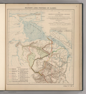
Boundary Lines Proposed or Claimed. 1. S Doc 91 55 2. The Orinoco - Essequibo Region, South America Compiled under the Direction of the Commission Appointed "To Investigate and Report upon the True Divisional Line between the Republic of Venezuela and British Guiana." 1897. Lith. by A. Hoen & Co., Baltimore, MD.
Publisher
United States of America
Author
Venezuela-British Guiana Boundary Commission
Full Title
Forests and Savannas. 2. S Doc 91 55 2. The Orinoco - Essequibo Region, South America, Compiled under the Direction of the Commission Appointed "To Investigate and Report upon the True Divisional Line between the Republic of Venezuela and British Guiana." Washington D.C. 1897. Lith. by A. Hoen & Co., Baltimore, MD.
Publisher
United States of America
Author
Mercator, Gerardus
Full Title
(Facsimile) Mercator - 1538. 16. S Doc 91 55 2. Historical Map Showing European Occupation in the Year 1597 - 1803. Gerardus Mercator 1538. Double Cordiform Map of the World by Gerard Mercator, 1538. Reproduced from Copy (in Nordenskjold's Facsimile Atlas, Stockholm, 1889, Pl. XLIII,) in Library of U.S. Geological Survey. Washington, D.C.)(A General View with Dates of Occupation and Abandonment). Lith. by A. Hoen & Co., Baltimore, MD.
Publisher
United States of America
Author
Finaeus, Orontius
Full Title
(Facsimile) Finaeus - 1566. 17. 53. Cordiform map of the world by Orontius Finaeus.Copper-print by Cimerlinus 1566. Reproduced from Facsimile of a Copper Print by J.P. Cimerlinus (in Nordenskjold's Facsimile Atlas, Stockholm, 1889, p. 89,) in Library of U.S. Geological Survey, Washington, D.C. Lith. by A. Hoen & Co., Baltimore, MD.
Publisher
United States of America
Author
Martyr, Peter
Full Title
(Facsimile) Martyr - 1534. 18. Map of America by Peter Martyr, Venice, 1534. Reproduced from Copy (in Nordenskjold's Facsimile Atlas, Stockholm, 1889, p. 107,) in Library of U.S. Geological Survey, Washington, D.C. Lith. by A. Hoen & Co., Baltimore, MD.
Publisher
United States of America
Author
Martyr, Peter
Full Title
(Facsimile) Martyr - 1587. 82. Map of the New World. From: Petrus Martyr, De orbe novo decades VIII, annot. Rich. Hakluyti. Paris. 1587. Reproduced from Copy (in Nordenskjold's Facsimile Atlas, Stockholm, 1889, p. 131,) in Library of U.S. Geological Survey, Washington, D.C. Lith. by A. Hoen & Co., Baltimore, MD.
Publisher
United States of America
Author
Ortelius, Abraham
Full Title
(Facsimile) Ortelius 1587. 20. Map of America by Abraham Ortelius, Antwerp, 1587. Reproduced from Original (in a Collection Labeled American Maps, Vol. I. No. 36.) in Library of U.S. Geological Survey, Washington, D.C. Lith. by A. Hoen & Co., Baltimore, MD.
Publisher
United States of America
Author
Raleigh, Walter
Full Title
(Facsimile) Raleigh - [1595?]. 21. Sir Walter Raleighs Karte von Guayana mit dem Lauf des Orinoco und des Maranon oder Amazonas 1595. Facsimile der im Katalog des Britishchen Museum enter Add. 17940 a aufgefuhrten Manuscript - Karte. Chart of Guiana by Sir Walter Raeigh, [1595?]. Reproduced from Copy (In Hamburgische Festschrift zur Erinnerung an die Entdeckung Amerika's Hamburg, 1892, Vol. 2,) in Library of U.S. Geological Survey, Washington, D.C. Lith. by A. Hoen & Co., Baltimore, MD.
Publisher
United States of America
Author
Speed, John
Full Title
(Facsimile) Speed - 1626. 22. Map of America by ohn Speed, London, 1626. Reproduced from Original (In his Project of the most Famous Parts of the World, London, 1631, pp. 9-10.) in Library of Congress, Washington, D.C. Lith. by A. Hoen & Co., Baltimore, MD.
Publisher
United States of America
Author
De Bry, Theodore
Full Title
(Facsimile) De Bry - 1599. 23. Map of Guinan by Theodore de Bry, 1599. Reproduced from Original (In his America,, Part 8. Frankfort on the Main, 1599, p.3) in Library of Congress, Washington, D.C. Lith. by A. Hoen & Co., Baltimore, MD.
Publisher
United States of America
Author
De Laet, Jan
Full Title
(Facsimile) De Laet - 1630. 24. Map of Guiana by Jan de Laet, Leyden, 1630. Reproduced from Original. Reproduced from Original (in his Beschryvinghe van Wes-Indien, Leyden, 1630, 1630, p. 552,) in Library of Congress, Washington, D.C. Lith. by A. Hoen & Co., Baltimore, MD.
Publisher
United States of America
Author
Blaeuw, William
Full Title
(Facsimile) Blaeuw - 1635. 25. Map of Guiana by William Blaeuw, Amsterdam, 1635. Reproduced from Original (in Nievwe Atlas, by Wm. and John Blaeuw, Amsterdam, 1635, Vol. 2, Fol. N,) in Library of Harvard College, Cambridge, Mass. Lith. by A. Hoen & Co., Baltimore, MD.
Publisher
United States of America
Author
Blaeuw, William
Full Title
(Facsimile) Blaeuw - 1667. 26. Map of Guiana by William Blaeuw, Amsterdam, 1667. Reproduced from Original (in Dovzieme Volume de la Geographie Blauiane contenant L'Amerique; Amsterdam, 1667, pp. 277-278,) in Library of Congress, Washington, D.C. Lith. by A. Hoen & Co., Baltimore, MD.
Publisher
United States of America
Author
Blaeuw, William
Full Title
(Facsimile) Blaeuw - 1640. S. Doc 91 55 2. 27. Reproduced by Photo-Lithography from the Original, British Museum, 4 Table 9, plate 120. Map of Guiana by William Blaeuw, Amsterdam, 1640. Reproduced from Copy (in British Blue Book, Venezuela No. 1, [1896] Appendix, No. III, Map No. 2.) Lith. by A. Hoen & Co., Baltimore, MD.
Publisher
United States of America
Author
Blaeuw, William
Full Title
(Facsimile) Blaeuw - [no date.] 28. S Doc 91 55 2. Map of Guiana by William Blaeuw, Amsterdam, [no date, probably betwee 1656 and 1667.] Reproduced from Original (in a Collection Labeled American Maps, Vol. 1, No. 73,) in Library of U.S. Geological Survey, Washington, D.C. Lith. by A. Hoen & Co., Baltimore, MD.
Publisher
United States of America
Author
Sanson D'Abbeville, N.
Full Title
(Facsimile) Sanson - 1650. 29. S Doc 91 55 2. Part of a Map of South America by N. Sanson D'Abbeville, Paris, 1650. Reproduced from Original in the Library of Harvard College, Cambridge, Mass. Lith. by A. Hoen & Co., Baltimore, MD.
Publisher
United States of America
Author
Sanson D'Abbeville, N.
Full Title
(Facsimile) - 1656. S. Doc 91 55 2. 30. Map of Guiana and Caribana by N. Sanson D'Abbeville, Paris, 1656. Reproduced from Original Submitted to the Commission by the Republic of Venzuela. Lith. by A. Hoen & Co., Baltimore, MD.
Publisher
United States of America
Author
de Vaugondy, Robert
Full Title
(Facsimile) Robert de Vaugondy - 1750. S. Doc 91 55 2. 31. Part of a Map of South America by Robert de Vaugondy, Paris, 1750. Reproduced from Original (in his Atlas Universel, Paris, 1757, Pl. 101,) in Library of Congress, Washington, D.C. Lith. by A. Hoen & Co., Baltimore, MD.
Publisher
United States of America
Author
de Vaugondy, Robert
Full Title
(Facsimile) Delamarche [1767?] S Doc 91 55 2. 32. Part of a Map by Robert De Vaugondy, Published by C.F. Delamarche, Paris, [1767?]. Reproduced from Original (Marked 3010/7) in Library of Harvard College, Cambridge, Mass.
Publisher
United States of America
Author
Popple, Henry
Full Title
(Facsimile) Popple - 1733. Map 3. Map of Surinam. 33. S Doc 91 55 2. Part of "A Map of the British Empire in America with the French and Spanish Settlements Adjacent Thereto," by Henry Popple, London, 1733. Reproduced from the map Entitled Map of Surinam (in British Blue Book, Venezuela No.1, [1896] Appendix, No. III, Map No. 3,) in Possession of the Commission. I.D.W.O. Ni. 1142c. Lithographed at the Intll. Div. W.O. Jan. 1896. Photo.Lith. by A. hoen & Co., Baltimore, MD.
Publisher
United States of America
Author
Popple, Henry
Full Title
(Facsimile) Popple - 1733. America Septentrionalis. S Doc 9a 55 2. Map of the British Empire in America with the French and Spanish Settlements Adjacent Thereto, by Henry Popple, London, 1733. W.H. Toms Sculp. Reproduced from Original (in a Collection Labeled American Maps, Vol. 2, No. 151,) in Library of U.S. Geological Survey, Washington, D.C. Photo.Lith. by A. Hoen & Co., Baltimore, MD.
Publisher
United States of America
Author
Popple, Henry
Full Title
(Facsimile) Popple - 1733. 35. S Doc 9a 55 2. "A Map of the British Empire in America with the French and Spanish Settlements Adjacent Thereto," by Henry Popple, London, 1733. Reproduced from Original in Library of Congress. Photo.Lith. by A. Hoen & Co., Baltimore, MD.
Publisher
United States of America
Author
Lisle, Guillaume de, 1675-1726
Full Title
(Facsimile) Delisle - 1700. S Doc 9a 55 2. Part of a Map of South America by William Delisle, 1700. Reproduced from Original (in a Collection Marked Old Maps of America, Map No. 6) in the Library of Congress, Washington, D.C. Photo.Lith. by A. Hoen & Co., Baltimore, MD.
Publisher
United States of America
Author
Lisle, Guillaume de, 1675-1726
Full Title
(Facsimile) Delisle - 1700. S Doc 9a 55 2. Part of a Map of the Northern Portion of South America by William Delisle, 1703. Reproduced from Original Submitted to the Commission by the Repulic of Venezuela. Photo.Lith. by A. Hoen & Co., Baltimore, MD.
Publisher
United States of America
Author
Lisle, Guillaume de, 1675-1726
Full Title
(Facsimile) Delisle - 1722. S Doc 9a 55 2. Part of a Map of America by William Delisle, Paris, 1722. Reproduced from Original (Marked 3008/3) in Library of Harvard College, Cambridge, Mass. Photo.Lith. by A. Hoen & Co., Baltimore, MD.
Publisher
United States of America
Author
Anville, Jean Baptiste Bourguignon d, 1697-1782
Full Title
(Facsimile) D'Anville - 1748. 39. S Doc 9a 55 2. Amerique Meridionale. Publiee sous les Auspices de Monseigneur le Duc D'Orleans ... Map of South America by J.B. D'Anville, Paris, 1748. Reproduced from Original (Marked 4576/2) in Library of Harvard College, Cambridge, Mass. Photo.Lith. by A. Hoen & Co., Baltimore, MD.
Publisher
United States of America
Author
Anville, Jean Baptiste Bourguignon d, 1697-1782
Full Title
(Facsimile) D'Anville - 1748. 40. S Doc 9a 55 2. Part of a Map of South America by J.B. D'Anville, Paris, 1748. Reproduced from Original (Marked 4576/2) in Library of Harvard College, Cambridge, Mass. Photo.Lith. by A. Hoen & Co., Baltimore, MD.
Publisher
United States of America
Author
Jefferys, Thomas
Full Title
(Facsimile) Jefferys - 1775. 41. S Doc 9a 55 2. Part of a Chart of the Coast of Guiana by Thomas Jefferys, London, 1775. Reproduced from Original (in his West-India Atlas, London, 1788, Pl. A1. 17,) in Library of Congress, Washington, D.C.. Photo.Lith. by A. Hoen & Co., Baltimore, MD.
Publisher
United States of America
Author
Jefferys, Thomas
Full Title
(Facsimile) Jefferys - 1781. 42. S Doc 9a 55 2. Part of a Chart of the Coast of Guiana by Thomas Jefferys, London, 1781. Reproduced from Original (in his West-India Atlas, London, 1783, Pl. XVII,) in Library of Congress, Washington, D.C.. Photo.Lith. by A. Hoen & Co., Baltimore, MD.
Publisher
United States of America
|