Browse All

1886 United States of America. World Atlas Map of the United States Showing the Are … |

1845 Unanimous Declaration Of The Thirteen Un … Separate Map The Unanimous Declaration Of The Thirtee … |

1829 Covers: Willard's History of the United … School Atlas (Covers to) A Series of Maps to Willard' … |

1829 Text Page: Willard's History of the Unit … School Atlas (Text Page to) A Series of Maps to Willa … |

1829 Introductory Map To Accompany Willard's … School Atlas Introductory Map. To Accompany Willard's … |

1829 First Map Or Map Of 1578 School Atlas First Map Or Map Of 1578. To Accompany W … |
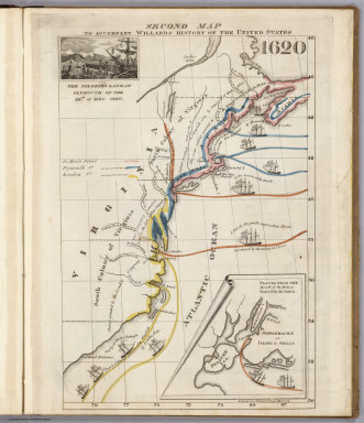
1829 Second Map 1620 School Atlas Second Map. To Accompany Willard's Histo … |

1829 Third Map or Map Of 1643 School Atlas Third Map or Map Of 1643. To Accompany W … |

1829 Fourth Map or Map Of 1692 School Atlas Fourth Map or Map Of 1692. To Accompany … |

1829 Fifth Map or Map Of 1733 School Atlas Fifth Map or Map Of 1733. To Accompany W … |

1829 Sixth Map or Map Of 1763 School Atlas Sixth Map or Map Of 1763. To Accompany W … |

1829 Seventh Map or Map Of 1776 School Atlas Seventh Map or Map Of 1776. To Accompany … |

1829 Eighth Map or Map Of 1789 School Atlas Eighth Map or Map Of 1789. To Accompany … |

1829 Principal Seat of the Revolutionary War … School Atlas Principal Seat of the Revolutionary War … |

1829 Ninth Map Or Map Of 1826 School Atlas Ninth Map Or Map Of 1826. To Accompany W … |

1829 Principal Seat of the War of 1812-13-14 School Atlas Principal Seat of the War of 1812-13-14. … |

1825 Etats-Unis de l'Amerique du Nord, l'adjo … National Atlas Carte de l'adjonction progressive des di … |

1825 Carte chronologique des Etats-Unis. National Atlas Carte chronologique des Etats-Unis, pres … |

1909 Presidents U.S., autographs, biographies … State Atlas The presidents of the United States. Aut … |

1909 (Presidents U.S., autographs, biographie … State Atlas (The presidents of the United States. Au … |

1909 (Presidents U.S., autographs, biographie … State Atlas (The presidents of the United States. Au … |

1898 1. Accessions of territory. Statistical Atlas 2. Accessions of territory. Julius Bien … |

1903 1. Accessions of territory. Statistical Atlas Accessions of territory from the Treaty … |

1932 Plate 2. Physical Geography and Vegetati … [Historical Atlas, National Atlas] Plate 2. Physical Geography and Vegetati … |

1932 Plate 3. Forests. [Historical Atlas, National Atlas] Plate 3. Forests; Growing Season. Area o … |

1932 Plate 4. Climate. [Historical Atlas, National Atlas] Plate 4. Climate. Snow Cover. Droughts. … |

1932 Plate 5. Climate. [Historical Atlas, National Atlas] Plate 5. Climate. Temperature. Rainfall. |

1932 Plate 6. Mineral Resources. [Historical Atlas, National Atlas] Plate 6. Mineral Resources. Coal Fields, … |

1932 Plate 7. Mineral Resources. [Historical Atlas, National Atlas] Plate 7. Mineral Resources. Oil and Gas … |

1502 Plate 9. Facsimile Cartography 1492-1867 … [Historical Atlas, National Atlas] Plate 9. Cartography 1492-1867. Cantino … |

1529 Plate 13 Facsimile Cartography 1492-1867 … [Historical Atlas, National Atlas] Plate 13. Cartography 1492-1867. Verraza … |

1536 Plate 14. Facsimile Cartography 1492-186 … [Historical Atlas, National Atlas] Plate 14. Cartography 1492-1867. Harleia … |

1569 Plate 15. Facsimile Cartography 1492-186 … [Historical Atlas, National Atlas] Plate 15. Cartography 1492-1867. Mercato … |

1591 Plate 16. Facsimile Cartography 1492-186 … [Historical Atlas, National Atlas] Plate 16. Cartography 1492-1867. Lemoyne … |

1600 Plate 17. Facsimile Cartography 1492-186 … [Historical Atlas, National Atlas] Plate 17. Cartography 1492-1867. Cortes … |

1612 Plate 18. Facsimile Cartography 1492-186 … [Historical Atlas, National Atlas] Plate 18. Cartography 1492-1867. Smith M … |

1688 Plate 20. Facsimile Cartography 1492-186 … [Historical Atlas, National Atlas] Plate 20. Cartography 1492-1867. Hondius … |

1630 Plate 21. Facsimile Cartography 1492-186 … [Historical Atlas, National Atlas] Plate 21. Cartography 1492-1867. De Laet … |

1700 Plate 22. Facsimile Cartography 1492-186 … [Historical Atlas, National Atlas] Plate 22. Cartography 1492-1867. Delisle … |

1750 Plate 23. Facsimile Cartography 1492-186 … [Historical Atlas, National Atlas] Plate 23. Delisle Map, 1703. Delisle Map … |

1718 Plate 24. Facsimile Cartography 1492-186 … [Historical Atlas, National Atlas] Plate 24. Cartography 1492-1867. Delisle … |

1798 Plate 25. Facsimile Cartography 1492-186 … [Historical Atlas, National Atlas] Plate 25. Cartography 1492-1867. Muller … |

1755 Plate 26. Facsimile Cartography 1492-186 … [Historical Atlas, National Atlas] Plate 26. Cartography 1492-1867. Evans M … |

1733 Plate 27. Facsimile Cartography 1492-186 … [Historical Atlas, National Atlas] Plate 27. Cartography 1492-1867. Popple … |

1804 Plate 28. Facsimile Cartography 1492-186 … [Historical Atlas, National Atlas] Plate 28. Cartography 1492-1867. Lewis M … |

1814 Plate 29. Facsimile Cartography 1492-186 … [Historical Atlas, National Atlas] Plate 29. Cartography 1492-1867. Arrowsm … |

1811 Plate 30. Facsimile Cartography 1492-186 … [Historical Atlas, National Atlas] Plate 30. Cartography 1492-1867. Pike Ma … |

1840 Plate 31. Facsimile Cartography 1492-186 … [Historical Atlas, National Atlas] Plate 31. Cartography 1492-1867. Bonnevi … |

1867 Plate 32. Facsimile Cartography 1492-186 … [Historical Atlas, National Atlas] Plate 32. Cartography 1492-1867. Clark M … |

1650 Plate 33. Facsimile Cartography 1492-186 … [Historical Atlas, National Atlas] Plate 33. Indians. Indian Tribes and Lin … |