Who What Where WhenREMOVEWHO
WHEN
|
Author
Colton, G.W.
Full Title
Map of the United States Showing the Area, Acquisition & Transfer of Territory. (Published by) G. W & C. B. Colton & Co., No. 172 William St. New York.
Publisher
G. W & C. B. Colton & Co.
Author
Phelps, Humphrey
Full Title
The Unanimous Declaration Of The Thirteen United States of America. In Congress July 4th, 1776 ... Published and For Sale by Humphrey Phelps, No. 144 Fulton St., near Broadway, N. York. Entered ... 1845, by H. Phelps ... New York. Barritt, Sc.
Publisher
H. Phelps
Author
Willard, Emma
Full Title
(Covers to) A Series of Maps to Willard's History of the United States, Or, Republic Of America. Designed For Schools And Private Libraries. New-York: White, Gallaher & White, 108 Pearl-street. 1829. Clayton & Van Norden, Printers, 64 Pine-street.
Publisher
White, Gallaher, & White
Author
Willard, Emma
Full Title
(Text Page to) A Series of Maps to Willard's History of the United States, Or, Republic Of America. Designed For Schools And Private Libraries. New-York: White, Gallaher & White, 108 Pearl-street. 1829. Clayton & Van Norden, Printers, 64 Pine-street.
Publisher
White, Gallaher, & White
Author
Willard, Emma
Full Title
Introductory Map. To Accompany Willard's History Of The United States. Locations and Wanderings Of The Aboriginal Tribes. (Arrow) Shows The Direction Of their Wanderings. Engraved & Printed by Saml. Maverick.
Publisher
White, Gallaher, & White
Author
Willard, Emma
Full Title
First Map Or Map Of 1578. To Accompany Willard's History Of The United States. (Inset) Queen Elizabeth Signs for Sir Humphrey Gilbert. The First patent Granted by an English Sovereign to Lands Within the Territory of the United States 1578. Engraved & Printed by Saml. Maverick.
Publisher
White, Gallaher, & White
Author
Willard, Emma
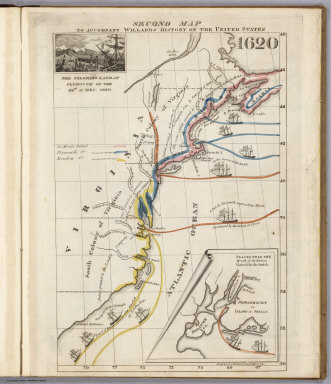
Full Title
Second Map. To Accompany Willard's History Of The United States 1620. (Inset) The Pilgrims Land at Plymouth on the 22nd. of Dec. 1620. (inset map) Places Near The Mouth of the Hudson Visited by the Dutch. Engraved & Printed by Saml. Maverick.
Publisher
White, Gallaher, & White
Author
Willard, Emma
Full Title
Third Map or Map Of 1643. To Accompany Willard's History Of The United States. (Inset) The Commencement of the Confederacy in the Union of Plymouth and Massachusetts and New Haven and Connecticut 1643. (inset map) Places Mentioned in the History of the Pequod War. Engraved & Printed by Saml. Maverick N.Y.
Publisher
White, Gallaher, & White
Author
Willard, Emma
Full Title
Fourth Map or Map Of 1692. To Accompany Willard's History Of The United States. (Inset) Massachusetts Receives a New Charter, Including Maine and Other Large Territories by the Arrival of Sir Wm. Phipps. (inset map) Places Mentioned in the History of King Philip's War. (Engraved & Printed by) Saml. Maverick & Co. N.Y.
Publisher
White, Gallaher, & White
Author
Willard, Emma
Full Title
Fifth Map or Map Of 1733. To Accompany Willard's History Of The United States. (Inset) Genl. Oglethorpe with a Colony Commence the Settlement of Georgia 1733. He meets the Indian Chief's in Council at Savannah. (Engraved & Printed by) Saml. Maverick & Co. N.Y.
Publisher
White, Gallaher, & White
Author
Willard, Emma
Full Title
Sixth Map or Map Of 1763. To Accompany Willard's History Of The United States. (Inset) The Death of Gen. Wolf Occurs at the Time of Quebec's Being Taken by the English ... that leads to the Peace of Paris 1763. (inset map) Quebec. Engraved & Printed by Saml. Maverick.
Publisher
White, Gallaher, & White
Author
Willard, Emma
Full Title
Seventh Map or Map Of 1776. To Accompany Willard's History Of The United States. (Inset) A Committee of Five draw up the Declaration of Independence. 1776. (inset map) Boston and Vicinity. (inset) (untitle map showing Lake George and surroundings). (inset) Charleston and Vicinity. Engraved & Printed by Saml. Maverick &Co. N.Y.
Publisher
White, Gallaher, & White
Author
Willard, Emma
Full Title
Eighth Map or Map Of 1789. To Accompany Willard's History Of The United States. (Inset) Federal Government Commen CD 1789. (2 untitled inset maps). (Engraved & Printed by) Saml. Maverick & Co. N.Y.
Publisher
White, Gallaher, & White
Author
Willard, Emma
Full Title
Principal Seat of the Revolutionary War in the Southern Section of the U.S. To Accompany Willard's History Of The United States. (inset map) Principal Seat of the Revolutionary War in the northern section of the U.S. Engraved & Printed by Saml. Maverick.
Publisher
White, Gallaher, & White
Author
Willard, Emma
Full Title
Ninth Map Or Map Of 1826. To Accompany Willard's History Of The United States. Referred to in the History, As the Map of the President Day. 1826. Saml. Maverick & Co. N.Y.
Publisher
White, Gallaher, & White
Author
Willard, Emma
Full Title
Principal Seat of the War of 1812-13-14. To Accompany Willard's History Of The United States. Engraved & Printed by Saml. Maverick. N.Y.
Publisher
White, Gallaher, & White
Full Title
Carte de l'adjonction progressive des divers etats au territoire et a l'union constitutionnelle des Etats-Unis de l'Amerique du Nord. 1825.
Publisher
J. Carez
Full Title
Carte chronologique des Etats-Unis, presentant les principaux evenements de leurs annales, depuis leur etablissement jusqu'a la Declaration de l'Independance. Fonderie et Imprimerie de J. Carez. (1825)
Publisher
J. Carez
Full Title
The presidents of the United States. Autographs and biographies. (Published by Ellis A. Davis. Berkeley, Cal. Seattle. 1909)
Publisher
E.A. Davis
Full Title
(The presidents of the United States. Autographs and biographies. Published by Ellis A. Davis. Berkeley, Cal. Seattle. 1909)
Publisher
E.A. Davis
Full Title
(The presidents of the United States. Autographs and biographies. Published by Ellis A. Davis. Berkeley, Cal. Seattle. 1909)
Publisher
E.A. Davis
Full Title
2. Accessions of territory. Julius Bien & Co. Lith., N.Y. (1898)
Publisher
U.S. Census Office
Full Title
Accessions of territory from the Treaty of Peace to the Gadsden Purchase. (Prepared under the supervision of Henry Gannett, Geographer of the Twelfth Census. United States Census Office, 1903). Julius Bien & Co., N.Y.
Publisher
U.S. Census Office
Author
[Paullin, Charles O., Wright, John K.]
Full Title
Plate 2. Physical Geography and Vegetation. Relief; Soil Regions. Physical Divisions. Vegetation Regions.
Publisher
[Carnegie Institution of Washington, American Geographical Society of New York]
Author
[Paullin, Charles O., Wright, John K.]
Full Title
Plate 3. Forests; Growing Season. Area of Virgin Forest 1620. Area of Virgin Forest 1850. Area of Virgin Forest 1926. National Forest 1930. Average Length of Growing Season.
Publisher
[Carnegie Institution of Washington, American Geographical Society of New York]
Author
[Paullin, Charles O., Wright, John K.]
Full Title
Plate 4. Climate. Snow Cover. Droughts. Relative Humidity. Cloudiness. Pressure.
Publisher
[Carnegie Institution of Washington, American Geographical Society of New York]
Author
[Paullin, Charles O., Wright, John K.]
Full Title
Plate 5. Climate. Temperature. Rainfall.
Publisher
[Carnegie Institution of Washington, American Geographical Society of New York]
Author
[Paullin, Charles O., Wright, John K.]
Full Title
Plate 6. Mineral Resources. Coal Fields, Distribution and Production of Iron Ore.
Publisher
[Carnegie Institution of Washington, American Geographical Society of New York]
Author
[Paullin, Charles O., Wright, John K.]
Full Title
Plate 7. Mineral Resources. Oil and Gas Fields. Gold, Silver, and Copper Districts.
Publisher
[Carnegie Institution of Washington, American Geographical Society of New York]
Author
[Paullin, Charles O., Wright, John K.]
Full Title
Plate 9. Cartography 1492-1867. Cantino Map, ca. 1502. (Facsimile).
Publisher
[Carnegie Institution of Washington, American Geographical Society of New York]
Author
[Paullin, Charles O., Wright, John K.]
Full Title
Plate 13. Cartography 1492-1867. Verrazano Map, 1529. (Facsimile).
Publisher
[Carnegie Institution of Washington, American Geographical Society of New York]
Author
[Paullin, Charles O., Wright, John K.]
Full Title
Plate 14. Cartography 1492-1867. Harleian Map ca. 1536. (Facsimile).
Publisher
[Carnegie Institution of Washington, American Geographical Society of New York]
Author
[Paullin, Charles O., Wright, John K.]
Full Title
Plate 15. Cartography 1492-1867. Mercator Map, 1569. (Facsimile).
Publisher
[Carnegie Institution of Washington, American Geographical Society of New York]
Author
[Paullin, Charles O., Wright, John K.]
Full Title
Plate 16. Cartography 1492-1867. Lemoyne Map, 1591. (Facsimile).
Publisher
[Carnegie Institution of Washington, American Geographical Society of New York]
Author
[Paullin, Charles O., Wright, John K.]
Full Title
Plate 17. Cartography 1492-1867. Cortes Map, 1520. Turin Map, ca. 1523. Vizcaino Map, 1603. Molineaux-Wright Map, 1600. Tattonus Map, 1600. (Facsimiles).
Publisher
[Carnegie Institution of Washington, American Geographical Society of New York]
Author
[Paullin, Charles O., Wright, John K.]
Full Title
Plate 18. Cartography 1492-1867. Smith Map, 1612. Champlain Map, 1612. (Facsimiles).
Publisher
[Carnegie Institution of Washington, American Geographical Society of New York]
Author
[Paullin, Charles O., Wright, John K.]
Full Title
Plate 20. Cartography 1492-1867. Hondius Map, 1630. Sanson, 1656. Jesuit Map 1672. Raffeix Map, 1688. (Facsimiles).
Publisher
[Carnegie Institution of Washington, American Geographical Society of New York]
Author
[Paullin, Charles O., Wright, John K.]
Full Title
Plate 21. Cartography 1492-1867. De Laet Map, 1630. (Facsimile).
Publisher
[Carnegie Institution of Washington, American Geographical Society of New York]
Author
[Paullin, Charles O., Wright, John K.]
Full Title
Plate 22. Cartography 1492-1867. Delisle Map, 1700. Gentil Map, ca. 1700. (Facsimiles).
Publisher
[Carnegie Institution of Washington, American Geographical Society of New York]
Author
[Paullin, Charles O., Wright, John K.]
Full Title
Plate 23. Delisle Map, 1703. Delisle Map 1750. Bellin Map, 1743. (Facsimiles).
Publisher
[Carnegie Institution of Washington, American Geographical Society of New York]
Author
[Paullin, Charles O., Wright, John K.]
Full Title
Plate 24. Cartography 1492-1867. Delisle Map, 1718. (Facsimile).
Publisher
[Carnegie Institution of Washington, American Geographical Society of New York]
Author
[Paullin, Charles O., Wright, John K.]
Full Title
Plate 25. Cartography 1492-1867. Muller Map, 1754. Vancouver Map, 1798. (Facsimiles).
Publisher
[Carnegie Institution of Washington, American Geographical Society of New York]
Author
[Paullin, Charles O., Wright, John K.]
Full Title
Plate 26. Cartography 1492-1867. Evans Map, 1755. (Facsimile).
Publisher
[Carnegie Institution of Washington, American Geographical Society of New York]
Author
[Paullin, Charles O., Wright, John K.]
Full Title
Plate 27. Cartography 1492-1867. Popple Map, 1733. (Facsimile).
Publisher
[Carnegie Institution of Washington, American Geographical Society of New York]
Author
[Paullin, Charles O., Wright, John K.]
Full Title
Plate 28. Cartography 1492-1867. Lewis Map, 1804. (Facsimile).
Publisher
[Carnegie Institution of Washington, American Geographical Society of New York]
Author
[Paullin, Charles O., Wright, John K.]
Full Title
Plate 29. Cartography 1492-1867. Arrowsmith Map, 1814. (Facsimile).
Publisher
[Carnegie Institution of Washington, American Geographical Society of New York]
Author
[Paullin, Charles O., Wright, John K.]
Full Title
Plate 30. Cartography 1492-1867. Pike Map, 1810. Humboldt Map, 1811. (Facsimiles).
Publisher
[Carnegie Institution of Washington, American Geographical Society of New York]
Author
[Paullin, Charles O., Wright, John K.]
Full Title
Plate 31. Cartography 1492-1867. Bonneville Map, 1837. Greenhow Map. 1840. Pike Map of Mississippi River, 1810. (Facsimiles).
Publisher
[Carnegie Institution of Washington, American Geographical Society of New York]
Author
[Paullin, Charles O., Wright, John K.]
Full Title
Plate 32. Cartography 1492-1867. Clark Map, 1810. Chapin Map, 1839. Smith Map, 1843. Colton Map, 1867. (Facsimiles).
Publisher
[Carnegie Institution of Washington, American Geographical Society of New York]
Author
[Paullin, Charles O., Wright, John K.]
Full Title
Plate 33. Indians. Indian Tribes and Linguistic Stocks, 1650.
Publisher
[Carnegie Institution of Washington, American Geographical Society of New York]
|