Browse All

1861 Plate 37. Indians. Indian Missions, 1567 … [Historical Atlas, National Atlas] Plate 37. Indians. Indian Missions, 1567 … |

1706 Plate 38. Explorations. Spanish Explorat … [Historical Atlas, National Atlas] Plate 38. Explorations. Spanish Explorat … |

1852 Plate 39. Explorers. French and American … [Historical Atlas, National Atlas] Plate 39. Explorers. French Explorations … |

1730 Plate 40. Lands. Divisions of Land near … [Historical Atlas, National Atlas] Plate 40. Lands. Divisions of Land near … |

1825 Plate 41. Lands. [Historical Atlas, National Atlas] Plate 41. Lands. Possessions of European … |

1732 Plate 42. Lands. Colonial Grants, 1703-1 … [Historical Atlas, National Atlas] Plate 42. Lands. Colonial Grants, 1703-1 … |

1732 Plate 43. Lands. Colonial Grants, 1603-1 … [Historical Atlas, National Atlas] Plate 43. Lands. Colonial Grants, 1603-1 … |

1795 Plate 44. Lands. Maine, 1795. Plymouth C … [Historical Atlas, National Atlas] Plate 44. Lands. Divisions of Land in Ma … |

1932 Plate 45. Lands. Grants by Georgia, 1789 … [Historical Atlas, National Atlas] Plate 45. Lands. Grants of Western Lands … |

1932 Plate 45. Lands. [Historical Atlas, National Atlas] Plate 46. Lands. British Possessions aft … |

1932 Plate 47. Lands. [Historical Atlas, National Atlas] Plate 47. Lands. Indian Cessions 1750-18 … |

1796 Plate 48. Lands. Public Lands under Act … [Historical Atlas, National Atlas] Plate 48. Lands. System of Survey of Pub … |

1846 Plate 49. Lands, Territorial Claims, Nor … [Historical Atlas, National Atlas] Plate 49. Lands. Territorial Claims and … |

1787 Plate 50. Facsimile Map of Land Grants 1 … [Historical Atlas, National Atlas] Plate 50. Lands. Lands Granted to States … |

1774 Plate 51. Lands. Fairfax Lands, 1736-173 … [Historical Atlas, National Atlas] Plate 51. Lands. Survey of Fairfax Lands … |

1809 Plate 52. Lands. Kaskaskia, Illinois 807 … [Historical Atlas, National Atlas] Plate 52. Lands. A French Settlement, Ka … |

1798 Plate 53. Lands. Mount Vernon, Virginia, … [Historical Atlas, National Atlas] Plate 53. Lands. Southern Plantation, Mo … |

1932 Plate 54. Lands. Springfield, Illinois ( … [Historical Atlas, National Atlas] Plate 54. Lands. A Modern City, Springfi … |

1914 Plate 55. Lands. Springfield, Illinois, … [Historical Atlas, National Atlas] Plate 55. Lands. A Modern City, Springfi … |

1932 Plate 56. Lands. Federal Land Grants for … [Historical Atlas, National Atlas] Plate 56. Lands. A Western Town: Carroll … |

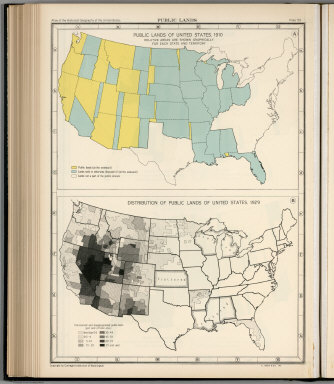
1932 Plate 57. Public Lands of United States, … [Historical Atlas, National Atlas] Plate 57. Public Lands. Public Lands of … |

1932 Plate 58. Public Lands of United States, … [Historical Atlas, National Atlas] Plate 58. Public Lands. Public Lands of … |
1932 Plate 59. Public Lands of United States, … [Historical Atlas, National Atlas] Plate 59. Public Lands. Public Lands of … |

1932 Plate 60. Settlement and Population, 166 … [Historical Atlas, National Atlas] Plate 60. Settlement and Population, 166 … |
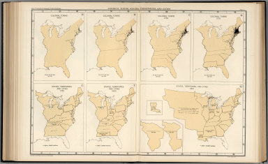
1932 Plate 61. Colonial Towns, States, Territ … [Historical Atlas, National Atlas] Plate 61. Colonial Towns, States, Territ … |

1932 Plate 62. States, Territories and Cities … [Historical Atlas, National Atlas] Plate 62. States, Territories and Cities … |

1932 Plate 63. States, Territories and Cities … [Historical Atlas, National Atlas] Plate 63. States, Territories and Cities … |

1932 Plate 64. States, Territories and Cities … [Historical Atlas, National Atlas] Plate 64. States, Territories and Cities … |

1932 Plate 65. States, Territories and Cities … [Historical Atlas, National Atlas] Plate 65. States, Territories and Cities … |

1932 Plate 66. States, Territories and Cities … [Historical Atlas, National Atlas] Plate 66. States, Territories and Cities … |

1932 Plate 67. States and Cities: Population, … [Historical Atlas, National Atlas] Plate 67. States and Cities: Population. … |

1932 Plate 68. Population. Slaves, 1850 - 186 … [Historical Atlas, National Atlas] Plate 68. Population. Slaves, 1850. Slav … |

1932 Plate 69. Population. Free Negroes, 1860 … [Historical Atlas, National Atlas] Plate 69. Population. Free Negroes, 1860 … |

1932 Plate 70. Population: Emigration to the … [Historical Atlas, National Atlas] Plate 70. Population: Emigration to the … |

1932 Plate 71. Population. Foreign-Born Popul … [Historical Atlas, National Atlas] Plate 71. Population. Foreign-Born Popul … |

1932 Plate 72. Population. Foreign-Born Popul … [Historical Atlas, National Atlas] Plate 72. Population. Foreign-Born Popul … |

1932 Plate 73. Population. Foreign-Born Popul … [Historical Atlas, National Atlas] Plate 73. Population. Foreign-Born Popul … |

1932 Plate 74. Population. Foreign-Born Popul … [Historical Atlas, National Atlas] Plate 74. Population. Foreign-Born Popul … |

1932 Plate 75. Population. Foreign-Born Popul … [Historical Atlas, National Atlas] Plate 75. Population. Foreign-Born Popul … |

1932 Plate 76. Population. Foreign-Born Popul … [Historical Atlas, National Atlas] Plate 76. Population. Foreign-Born Popul … |

1932 Plate 77. Population. Density of Populat … [Historical Atlas, National Atlas] Plate 77. Population. Density of Populat … |

1932 Plate 78. Population. Density of Populat … [Historical Atlas, National Atlas] Plate 78. Population. Density of Populat … |

1932 Plate 79. Density of Population, 1900 - … [Historical Atlas, National Atlas] Plate 79. Density of Population. Density … |

1932 Plate 80. Population: Colleges and Unive … [Historical Atlas, National Atlas] Plate 80. Population: Colleges and Unive … |

1932 Plate 81. Colleges and Universities, 186 … [Historical Atlas, National Atlas] Plate 81. Colleges and Universities. Col … |

1932 Plate 82. Churches, 1775-1776. [Historical Atlas, National Atlas] Plate 82. Churches. Congregationalist, 1 … |

1932 Plate 83. Churches, 1860. [Historical Atlas, National Atlas] Plate 83. Churches. Methodist, 1860. Bap … |

1932 Plate 84. Churches, 1860. [Historical Atlas, National Atlas] Plate 84. Churches. Congregational, 1860 … |

1932 Plate 85. Churches, 1860. [Historical Atlas, National Atlas] Plate 85. Churches. Catholic, 1860. Meth … |

1932 Plate 86. Churches, 1890. [Historical Atlas, National Atlas] Plate 86. Churches. Baptist, 1890. Presb … |