Browse All

1879 New map of the American Overland Route. [Pocket Map, Timetable Map] New map of the American Overland Route s … |

1879 Cover: Union and Central Pacific Railroa … [Pocket Map, Timetable Map] (Covers to) Union and Central Pacific Ra … |

1879 Text Page: Union and Central Pacific Rai … [Pocket Map, Timetable Map] (Text Page to) Union and Central Pacific … |

1888 Land grant W. Wash. & N. Oregon. Pocket Map Map showing land grant of the Northern P … |

1888 Cover: Land grant W. Wash. & N. Oregon. Pocket Map (Covers to) Map showing land grant of th … |

1888 Text Page: Land grant W. Wash. & N. Oreg … Pocket Map (Text Page to) Map showing land grant of … |

1887 National City, San Diego Co. [Separate Map, View] Birds-eye view of National City, San Die … |

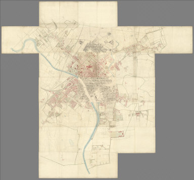
1852 Sheet 1: Plan of York, 1852 [City Atlas, Survey Map] Sheet 1: York. Surveyed in 1850, by Capt … |

1852 Sheet 2: Plan of York, 1852 [City Atlas, Survey Map] Sheet 2: York. Surveyed in 1850, by Capt … |

1852 Sheet 3: Plan of York, 1852 [Survey Map, City Atlas] Sheet 3: York. Surveyed in 1850, by Capt … |

1852 Sheet 4: Plan of York, 1852 [Survey Map, City Atlas] Sheet 4: York. Surveyed in 1850, by Capt … |

1852 Sheet 5: Plan of York, 1852 [Survey Map, City Atlas] Sheet 5: York. Surveyed in 1850, by Capt … |

1852 Sheet 6: Plan of York, 1852 [Survey Map, City Atlas] Sheet 6: York. Surveyed in 1850, by Capt … |

1852 Sheet 7: Plan of York, 1852 [City Atlas, Survey Map] Sheet 7: York. Surveyed in 1850, by Capt … |

1852 Sheet 8: Plan of York, 1852 [Survey Map, City Atlas] Sheet 8: York. Surveyed in 1850, by Capt … |

1852 Sheet 9: Plan of York, 1852 [City Atlas, Survey Map] Sheet 9: York. Surveyed in 1850, by Capt … |

1852 Sheet 10: Plan of York, 1852 [Survey Map, City Atlas] Sheet 10: York. Surveyed in 1850, by Cap … |

1852 Sheet 11: Plan of York, 1852 [City Atlas, Survey Map] Sheet 11: York. Surveyed in 1850, by Cap … |

1852 Sheet 12: Plan of York, 1852 [Survey Map, City Atlas] Sheet 12: York. Surveyed in 1850, by Cap … |

1852 Sheet 13: Plan of York, 1852 [City Atlas, Survey Map] Sheet 13: York. Surveyed in 1850, by Cap … |

1852 Sheet 14: Plan of York, 1852 [Survey Map, City Atlas] Sheet 14: York. Surveyed in 1850, by Cap … |

1852 Sheet 15: Plan of York, 1852 [Survey Map, City Atlas] Sheet 15: York. Surveyed in 1850, by Cap … |

1852 Sheet 16: Plan of York, 1852 [Survey Map, City Atlas] Sheet 16: York. Surveyed in 1850, by Cap … |

1852 Sheet 17: Plan of York, 1852 [Survey Map, City Atlas] Sheet 17: York. Surveyed in 1850, by Cap … |

1852 Sheet 18: Plan of York, 1852 [Survey Map, City Atlas] Sheet 18: York. Surveyed in 1850, by Cap … |

1852 Sheet 19: Plan of York, 1852 [Survey Map, City Atlas] Sheet 19: York. Surveyed in 1850, by Cap … |

1852 Sheet 20: Plan of York, 1852 [Survey Map, City Atlas] Sheet 20: York. Surveyed in 1850, by Cap … |

1852 Sheet 21: Plan of York, 1852 [City Atlas, Survey Map] Sheet 21: York. Surveyed in 1850, by Cap … |
1852 Composite: Sheets 1 - 21, Plan of York, … [City Atlas, Survey Map] (Composite to) (Sheets 1 - 21) York. Sur … |

1829 Maine, inhabited part. State Atlas Map of the inhabited part of the State o … |

1890 Township map Florida. Pocket Map Township map of Peninsular Florida issue … |

1890 Cover: Township map Florida. Pocket Map (Covers to) Township map of Peninsular F … |

1890 Title Page: Township map Florida. Pocket Map (Title Page to) Township map of Peninsul … |

1888 Map of the City of Oakland and Surroundi … Wall Map Map of the City of Oakland and Surroundi … |

1887 Cover: Guide to San Diego Bay Region, Ca … [Separate Map, View] (Covers to) Guide to San Diego Bay Regio … |

1887 Text Page: Guide to San Diego Bay Region … [Separate Map, View] (Text Page to) Guide to San Diego Bay Re … |

1868 Map of Lands of the Saucelito Land and F … Separate Map Map of Lands of the Saucelito Land and F … |

1897 Map of the city of Merced : Merced Co. C … Separate Map Map of the city of Merced : and subdivis … |

1905 Title Page: Sage, Dealey & Co. Probate a … Real Estate (Title Page to) Probate auction sale Tue … |

1905 Sage, Dealey & Co. Probate auction sale … Real Estate Probate auction sale Tuesday, March 21, … |

1905 (Continues) Sage, Dealey & Co. Probate a … Real Estate Probate auction sale Tuesday, March 21, … |

1914 Imperial Valley tract map Separate Map Imperial Valley tract map. Published by … |

1914 Irrigation district and road map, Imperi … Separate Map Irrigation district and road map, Imperi … |

1926 Windsor Farms, a residential development … Separate Map Windsor Farms, a residential development … |

1895 N.Y. land grants, patents, purchases. State Atlas Map of the state of New York showing the … |

1895 N.Y., Kings, Queens, Richmond, Rockland, … State Atlas New York, Kings, Queens, Richmond, Rockl … |

1893 Text Page: At Auction Broadside (Text Page) At Auction, 104 Lots at Pere … |

1893 Paradise Found! Broadside Paradise Found! (Looking South). Lith. H … |