Browse All

1860 Deutschland von 1649 bis 1792. Historical Atlas Deutschland von 1649 bis 1792. (with) An … |

1894 Camp Benson, Newport, Maine. State Atlas Map of Camp Benson, G.A.R. Association, … |

1857 A Complete map of the Crimea World Atlas A Complete Map of the Crimea Showing the … |
1895 Military map, W.T. Sherman. Military Atlas Military map of the marches of the Unite … |

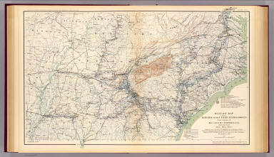
1895 Army of the Cumberland campaigns. Military Atlas Map prepared to exhibit the campaigns in … |

1895 Kansas, Texas, Indian Territory. Military Atlas Engineer Bureau, War Department. Section … |

1895 Utah Terr. & Mil. Dept. Military Atlas Territory and Military Department of Uta … |

1895 Charleston, defenses. Military Atlas Map of Charleston and its defenses, comp … |

1895 Wilmington, Ft. Caswell, Smith's Island, … Military Atlas Section of map of parts of Brunswick and … |

1895 Bentonville, N.C. Military Atlas Map illustrating the battle of Bentonvil … |

1895 California, Nevada, Oregon. Military Atlas Topographical map of California, Nevada, … |

1895 Chancellorsville; Buckingham, Appomattox … Military Atlas Sketch showing the positions of the Army … |

1895 Colton's U.S. section. Military Atlas Section of G. Woolworth Colton's new gui … |

1895 Ft. Anderson, N.C. Military Atlas Map of Fort Anderson, N.C. Captured Febr … |

1895 Virginia, Averell routes. Military Atlas Map of a part of Virginia exhibiting the … |

1895 USA Dec. 1860. Military Atlas Map of the United States of America show … |

1895 USA June 1861. Military Atlas Map of the United States of America show … |

1895 USA Dec. 1861. Military Atlas Map of the United States of America show … |

1895 USA June 1862. Military Atlas Map of the United States of America show … |

1895 USA Dec. 1862. Military Atlas Map of the United States of America show … |

1895 USA June 1863. Military Atlas Map of the United States of America show … |

1895 USA Dec. 1863. Military Atlas Map of the United States of America show … |

1895 USA June 1864. Military Atlas Map of the United States of America show … |

1895 USA Dec. 1864. Military Atlas Map of the United States of America show … |

1895 USA Apr. 1865. Military Atlas Map of the United States of America show … |

1742 Theatre de la guerre, Petite Tartarie, C … World Atlas Theatre de la guerre dans la Petite Tart … |

1742 2. pte. Crimee, Mer Noire. World Atlas Seconde partie de la Crimee, la Mer Noir … |

1742 Composite: Theatre de la guerre, Petite … World Atlas (Composite of) Theatre de la guerre dans … |

1801 Invasions England, Ireland. World Atlas The invasions of England and Ireland wit … |

1794 Netherlands (north) World Atlas A new map of the Netherlands or Low Coun … |

1794 Seat of war Netherlands. World Atlas A new map of the seat of war in the Neth … |

1877 Beaver, Cheyenne, Fort Union, Georgetown … Exploration Book Sketch of Beaver, Utah showing position … |

1808 Carta del' itinerarj militari da Bologna … Regional Atlas Carta del' itinerarj militari da Bologna … |

1808 Carta del' itinerarj militari da Bologna … Regional Atlas Carta del' itinerarj militari da Bologna … |

1808 No. 1. Ascoli, Leonessa, Teramo Regional Atlas No. 1. (Ascoli, Leonessa, Teramo). (to a … |

1860 Crimea. World Atlas A Complete Map of the Crimea Showing the … |

1943 Military Action of World War II World Atlas Military Actions of World War II. (Copyr … |

1783 Gibraltar. World Atlas Plan of the bay, rock and town of Gibral … |

1932 Plate 160. Military History. American Re … [Historical Atlas, National Atlas] Plate 160. Military History. The America … |

1932 Plate 161. Military History. Colonial Wa … [Historical Atlas, National Atlas] Plate 161. Military History. Colonial Wa … |

1932 Plate 162. Military History. 1812 - 1847 … [Historical Atlas, National Atlas] Plate 162. Military History. 1812. Jacks … |

1932 Plate 163. Military History. Civil War 1 … [Historical Atlas, National Atlas] Plate 163. Military History. Civil War 1 … |

1932 Plate 164. Military History. Virginia Ca … [Historical Atlas, National Atlas] Plate 164. Military History. Virginia Ca … |

1932 Plate 165. Military History. American Wa … [Historical Atlas, National Atlas] Plate 165. Military History. Spanish Ame … |

1907 British Naval Chart. Comparative Strengt … Statistical Atlas British Naval Chart. Comparative Strengt … |

1881 England and Wales to Illustrate the Mili … Statistical Atlas England and Wales to Illustrate the Mili … |

1881 Scotland to Illustrate the Military Cond … Statistical Atlas Scotland to Illustrate the Military Cond … |

1881 Ireland to Illustrate the Military Condi … Statistical Atlas Ireland to Illustrate the Military Condi … |

1895 Gauley Bridge. Military Atlas Military reconnaissance, vicinity of Gau … |

1895 Island No. 10, New Madrid. Military Atlas Map showing the system of rebel fortific … |