Who What Where WhenREMOVE |
Author
Renault, Jn. F.
Full Title
Plan of York Town In Virginia And Adjacent Country. Exhibiting the operations of the American French & English armies, during the siege at that place in Oct. 1781. Surveyed from the 22nd to the 28th Octr. Drawn by Jn. F. Renault, with a Crow-pen and presented to the Marques De La Fayette. Engraved by B. Tanner.
Publisher
No Publisher
Author
Ruger, Edward
Full Title
Map Prepared to exhibit the Campaigns in which the Army Of The Cumberland Took part during the War of the Rebellion. By order of Maj. Genl. Geo. H. Thomas. U.S.A. Compiled under the direction of Bvt. Major Genl. Z.B. Tower Chief Engr. Military Div. of the Tenn. by Ed. Ruger, Supt. Topl. Engr. Office at Nashville. Assistants. Capt. A. Kilp & Lieut. R. Flach 3rd U.S.C.A. (Heavy) & Asst. Top. Engrs. ... Photolith. by the N.Y. Lithg. Engrg. & Prtg. Co. 16 & 18 Park Place.
Publisher
N.Y. Litho & Engr.
Author
Hood, Washington
Full Title
Map Of The Seat Of War In Florida. Compiled By Order Of The Hon. Joel R. Poinsett, Secretary Of War, under the Direction of Col J.J. Abert U.S. Topt. Engineer, from the reconnoissances of the Officers of the U.S. Army, by Wash: Hood. Bureau of U.S. Topographical Engineers Washington City 1838. W.J. Stone Sc. Washn. City.
Publisher
U.S. Topographical Engineers
Author
United States. War Dept. Engineer Bureau
Full Title
Central Virginia showing Lieut Gen'l U.S. Grant's Campaign and Marches of the Armies under his Command in 1864-5. Engineer Bureau War Dept. Prepared by Order of the Secretary of War For the Officers of the U.S. Army under the command of Lieut. Gen. U.S. Grant.
Publisher
War Department
Author
United States. War Dept. Engineer Bureau
Full Title
Region embraced in the Operations of the Armies against Richmond and Petersburg. Engraved at the Engineer Bureau, War Dep. 1865. Authorities. North of James & Appomattox from Photograph Map Captured from the Enemy and Surveys of Maj. P.S. Michie Corps Of Engineers. South of Do. from Surveys of Col. N. Michler Corps Of Engineers.
Publisher
U.S.
Author
Harper's Weekly
Full Title
Map Of The Southern States, Including Rail Roads, County Towns, State Capitals, County Roads, The Southern Coast ... To Texas, Showing The Harbors, Inlets, Forts And Position Of Blockading Ships. Prepared For Harper's Weekly November 1861. (untitled inset map of Washington D.C. and vicinity).
Publisher
Harper's Weekly
Author
Peseux, M.
Full Title
Battlefields In Front Of Nashville where the United States Forces commanded by Major General Geo. H. Thomas defeated and routed the Rebel Army under General Hood December 15th and 16th 1864. Reduced and Engraved in the Engineer Bureau. Surveyed and drawn under the direction of Gen. Tower by M. Peseux. 39th Cong. 1st. Sess. - Report of the Chief Engineer U.S.A.
Publisher
U.S.
Author
Wyld, James, 1812-1887
Full Title
Wyld's Sketch of the Country Around Montreal, Shewing the Villages & Military Positions. London, Published by James Wyld, Geographer to the Queen, Charing Cross East, Der. 28th 1837 ... Day & Haghe Lithrs to The Queen, Gate St.
Publisher
James Wyld
Author
U.S. War Department, Chief of Engineers
Full Title
Map III illustrating the Military Operations of the Atlanta Campaign. This map includes the region extending from Rome, Kingston and Cassville on the north to include Dallas and Marietta on the south and exhibits the Works of the United States and Confederate Forces. 1864. Maj. Genl. W.T. Sherman, commanding U.S. Forces. Genl. J.E. Johnston, commanding Conf. Forces. Compiled by Authority of the Hon. The Secretary Of War ... 1876. Authorities. Surveys made by J.T. Dodge and H.H. Ruger; Civil Eng'rs. and Captured Confederate maps. Am. Photo-Lithographic Co. N.Y. (Osborne's Process.)
Publisher
American Photo-Lithographic Co.
Author
U.S. War Department, Chief of Engineers
Full Title
Map IV illustrating the Military Operations of the Atlanta Campaign. Embracing the region from Pine, Lost and Kennesaw Mountains south to include Atlanta, and its environs, exhibiting the lines of operations at Pine, Lost and Kennesaw Mts., at Smyrna Camp Ground, along the Chattahoochie river, and the investment of Atlanta. 1864. Maj. Genl. W.T. Sherman ... Genl. J.E. Johnston and J.B. Hood ... Compiled by Authority of the Secretary Of War ... 1874. Authorities Surveys made by J.T. Dodge and H.H. Ruger ... under the direction of Captain O.M. Poe ... Am. Photo-Lithographic Co. N.Y. (Osborne's Process.)
Publisher
American Photo-Lithographic Co.
Author
U.S. War Department, Chief of Engineers
Full Title
Map I illustrating the Military Operations of the Atlanta Campaign. This map embraces the region extending from the Tennessee River to the Oostanaula River and exhibits the Works of the United States and Confederate Forces. 1864. Maj. Genl. W.T. Sherman, commanding U.S. Forces. Genl. J.E. Johnston, commanding Conf. Forces. Compiled by Authority of the Hon. The Secretary Of War in the Office of the Chief of Engineers, U.S.A. 1875 ... American Photo-Lithographic Co. N.Y. (Osborne's Process.)
Publisher
American Photo-Lithographic Co.
Author
U.S. War Department, Chief of Engineers
Full Title
Map II illustrating the Military Operations of the Atlanta Campaign. This map includes the region from Resaca on the north to Ackworth on the south, and exhibits the Works of the United States and Confederate Forces. 1864. Maj. Genl. W.T. Sherman, commanding U.S. Forces. Genl. J.E. Johnston, commanding Conf. Forces. Compiled by Authority of the Hon. The Secretary Of War ...1877. Authorities made by J.T. Dodge and Edw. Ruger, Civil Eng'rs. and Captured Confederate maps. Am. Photo-Lithographic Co. N.Y. (Osborne's Process.)
Publisher
American Photo-Lithographic Co.
Author
U.S. War Department, Chief of Engineers
Full Title
Map V illustrating the Military Operations of the Atlanta Campaign. This map includes the region from the Chattahoochee River south to Jonesboro and Lovejoy's Station, and exhibits the Works of the United States and Confederate Forces. 1864. Maj. Genl. W.T. Sherman ... Genl. J.E. Johnston and J.B. Hood ... Compiled by Authority of the Hon. The Secretary Of War ... 1877. Authorities. Surveys made by J.T. Dodge & Edw. Ruger ... under the direction of Major O.M. Poe ... Am. Photo-Lithographic Co. N.Y. (Osborne's Process.)
Publisher
American Photo-Lithographic Co.
Author
U.S. War Department, Topographical Engineers
Full Title
"Surveys For Military Defences" Map Of N. Eastern Virginia And Vicinity Of Washington compiled in Topographical Engineers Office at Division Head Quarters Of General Irvin McDowell Arlington, January 1th 1862 corrected from recent Surveys and Reconnaissances under the direction of the Bureau Of Topographical Engineers August 1st 1862. Drawn By J.J. Young, W. Hesselbach. Engr. On Stone By J. Schedler, No. 120 Pearl St. N.Y. ...
Publisher
J. Schedler
Author
Duval, P.S. and Son
Full Title
Military Map Of The United States & Territories Showing The Location of the Military Posts, Arsenals, Navy Yards, & Ports of Entry. Compiled from Pub - Doc - 1861. Published by P.S. Duval & Son. Nos. 22&24 South 5th St. Philada. Entered ... 1861 by P.S. Duval & Son ... Penna. (inset) Pensacola & Perdido Bays. (untitled inset map of Key West).
Publisher
P.S. Duval & Son
Author
U.S. War Department, Topographical Engineers
Full Title
Siege Of Vera Cruz, by the U.S. Troops under Major General Scott, in March 1847, from Surveys made by Major Turnbull, Captains Hughes, McClellan & Johnston; Lieutenants Derby & Hardcastle, Topl. Engineers. Drawn by Capt. McClellan.
Publisher
No publisher
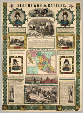
Author
Ensigns & Thayer
Full Title
Seat Of War & Battles. Map of the Seat of War. Entered ... 1847, by Ensigns & Thayer ... New York. Published By Ensigns & Thayer, 50 Ann Street, New York. And 12 Exchange St., Buffalo. Jos. Ward, 52 Cornhill St., Boston. Rufus Blanchard, Cincinnati.
Publisher
[Jos. Ward, Ensigns & Thayer ; Rufus Blanchard]
Author
Mitchell, Samuel Augustus
Full Title
Map Of The Seat Of War Gen. Taylor's Field Of Operations In Mexico. Philadelphia. Pubd. by S. Augustus Mitchell, N.E. Corr. of Market & 7th Sts. ... (inset map) The Late Battlefield. (inset) Map of the Seat Of War.
Publisher
S.A. Mitchell
Author
Anonymous
Full Title
(James River).
Publisher
No publisher
Author
Engineer Bureau War Dept
Full Title
Map Showing Route of Marches of the Army of Genl. W.T. Sherman From Atlanta, Ga. to Goldsboro, N.C. To accompany the report of operations From Savannah, Ga. to Goldsboro, N.C. Engineer Bureau. War Department. Prepared by Order of the Secretary of War For the Officers of the U.S. Army under the Command of Maj. Gen. W.T. Sherman.
Publisher
War Dept.
Author
U.S. War Department, Topographical Engineers
Full Title
Part of Washington County, MD. Bureau of Topographical Engineers September, 1862.
Publisher
Bureau of Topographical Engineers
Author
U.S. War Department, Topographical Engineers
Full Title
Sketch Of Country Between Haxall's Landing And Charles City Court House. Reconnoissances under the direction of Brig. Gen A.A. Humphreys, Comdg. Topl Engr's, by 1st Lieut. N. Bowen, Topl. Engrs., 2d Lieut. C. McClellan, 32d N.Y.. Vols., Mr. F.W. Dorr, Assist. U.S.C.S., Mr. Joseph McMakin, Drftsmn., Mr. H.H. Humpheys, Mr. Walter Taylor.
Publisher
Bureau of Topographical Engineers
Author
Hergesheimer, Edwin
Full Title
Washington County Maryland Compiled under the direction of Lieut. Col. J.N. Macomb Chf. Topl Engr for the use of Maj. Gen. Geo.B. McClellan Commanding Army of Potomac 1861. Drawn from Thomas Taggart's map by E. Hergesheimer, Photographs by G. Mathiot & D. Hinkle by permission of Prof. Bache Supt U.S. Coast Survey.
Publisher
U.S. Coast Survey
Author
Hergesheimer, Edwin
Full Title
Frederick County Maryland Prepared under the direction of Lieut. Col. J.N. Macomb Chf. Topl Engr for the use of Maj. Gen. G.B. McClellan Commanding U.S. Army 1861.
Publisher
U.S. Coast Survey
Author
Arrowsmith, Aaron
Full Title
Plan of the Operations of the British & Ottoman Forces in Egypt, From the 8th of March to the 2d. of Septr. 1801, when the French were Finally expelled from that Country. Composed from materials furnished by the Quarter Master Generals Department. London, Published by A. Arrowsmith, 1st. September 1802 No. 24 Rathbone Place. Engraved by S.J. Neele 352 Strand. (inset) Plate 1: (Alexandria peninsula on an enlarged scale.)
Publisher
A. Arrowsmith
Author
U.S. Coast Survey
Full Title
Part of Henrico County Virginia from Smith's Map in the collection of the U.S. Coast Survey Office. (Another title below) Part of Henrico County from Smith's Map of Virginia with additions of Topography from Surveys made under the direction of Genl A.A. Humphreys, Chief Topl Engr. Army of Potomac. Photographed at the U.S. Coast Survey Office July 1862. (title on verso) Map of Part of Henrico County Virga. ...
Publisher
U.S. Coast Survey
Author
Warren, Gouverneur Kemble, 1830-1882
Full Title
Military Map of Nebraska and Dakota...From the Explorations made by him in 1855, 6...and in 1857...
Publisher
U.S.
Author
Turner, Stanley
Full Title
Dated events, World War map, by Stanley Turner A.R.C.A. Printed in Canada by R.G. McLean Limited, Toronto. Copyright C.C. Petersen Advertising, 57 Qeen St. West, Toronto. Second edition. Price 25 cents. (insets) Western hemisphere. Part of the Eastern hemisphere. Africa.
Publisher
C.C. Petersen Publishing and Advertising
Author
[Faden, William, 1750?-1836, Gerlach, P.,Deputy Quarter Master General]
Full Title
Plan of the action at Huberton under Brigadier Genl. Frazier, supported by Major Genl. Reidesel, on the 7th. July 1777. Drawn by P. Gerlach, Deputy Quarter Master General. Engraved by Wm. Faden. London, published as the Act directs Feby. 1st 1780, by W. Faden Charing Cross.
Publisher
William Faden
Author
[Turner, Stanley, Petersen, C.C.]
Full Title
Dated Events. On To Tokyo. Map of the Pacific and the Far East. Stanley Turner, 44. Copyright, Canada and U.S.A., 1944, C.C. Petersen, Publishing and Advertising, Toronto, Canada. Seventh Edition.
Publisher
C.C. Petersen Publishing and Advertising
Author
[Harrison, Richard Edes, Army Information Branch, Army Service Forces]
Full Title
Newsmap. (War front near Florence, Italy. Guam, Agiguwant, Tinian and Saipan. Pacific Island Groups). Monday, July 31, 1944. ... Vol. III No. 15F. Prepared and Distributed by the Army Information Branch, Army Service Forces. Navy Distribution by Educational Services Section, BuPers, Navy Dept., Washington D.C. U.S. Government Printing Office: 1944 - 591000.
Publisher
Army Information Branch, Army Service Forces
Author
[Army Information Branch, Navy Educational Services Section]
Full Title
Major Bases Proposed for Postwar U.S. Navy. Japan. Newsmap for the Armed Forces. Monday, September 17, 1945. Volume IV No. 22F. Prepared and Distributed by the Army Information Branch, Army Service Forces, Navy Distribution by Educational Services Section, Bupers, Navy Dept., Washington D.C. U.S. Government Printing Office: 1945 - 854909. Comparison Chart of Non-Commissioned Grades and Ratings of the Armed Forces.
Publisher
Army Information Branch, Army Service Forces
Author
[Manning, F.E., Army Orientation Course, Special Service Division Army Service Forces]
Full Title
Target Tokyo. Newsmap. Monday, October 18, 1943. ... Vol. II No. 26. Prepared and Distributed by the Army Orientation Course. Special Service Division Army Service Forces, War Dept.,2E581 Pentagon Bldg., Washington D.C. U.S. Government Printing Office: 1943 - 538110.
Publisher
Special Service Division Army Service Forces, War Department
Author
[Manning, F.E., Army Orientation Course, Special Service Division Army Service Forces]
Full Title
Newsmap. Monday, October 18, 1943. ... Vol. II No. 26. Roads to Rome. Southwest Pacific. Wake island. (World).
Publisher
Special Service Division Army Service Forces, War Department
Author
[Manning, F.E., Army Orientation Course, Special Service Division Army Service Forces]
Full Title
Target Berlin. Newsmap. Monday, October 25, 1943. ... Vol. II No. 27. Prepared and Distributed by the Army Orientation Course. Special Service Division Army Service Forces, War Dept.,2E581 Pentagon Bldg., Washington D.C. U.S. Government Printing Office: 1943 - 538110.
Publisher
Special Service Division Army Service Forces, War Department
Author
[Manning, F.E., Army Orientation Course, Special Service Division Army Service Forces]
Full Title
Newsmap. Monday, October 25, 1943. ... Vol. II No. 27. Bridgeheads across the Dnepr River. Operations in Burma. New Guinea. (Italy-Greece-Turkey).
Publisher
Special Service Division Army Service Forces, War Department
Author
Alcoa Map Department, Aluminum Company of America
Full Title
Global Map for Global War and Global Peace.
Publisher
Aluminum Company of America (Alcoa)
Author
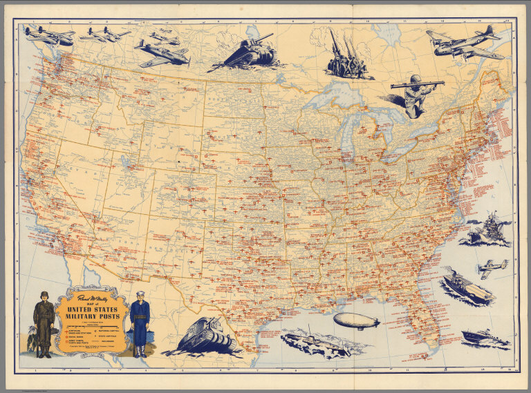
Rand McNally & Co.
Full Title
Rand McNally Map of United States Military Posts.
Publisher
Rand McNally & Co.
Author
Toronto Star
Full Title
Star Weekly Map of the Axis Encirclement. January 9, 1943.
Publisher
Toronto Star
Author
Burke, Howard
Full Title
Two ways to reach Japan - One may take a decade. Los Angels Examiner ... Monday January 11, 1943. 22 Section 1. Howard Burke. (inset) Kusaie.
Publisher
Los Angeles Examiner
Author
Burke, Howard
Full Title
The Pacific - Vital area for United States and Japan. Los Angels Examiner ... November 1942. Howard Burke. (inset) Palau Islands.
Publisher
Los Angeles Examiner
Author
Los Angeles Times
Full Title
Saipan conquest sets pattern for vast aerial operations. Los Angeles Times. Monday July 10, 1944.
Publisher
Los Angeles Times
Author
Pacific Stars and Stripes
Full Title
Pacific Stars and Stripes Map of the (Korean) War. (inset) 38th Parallel.
Publisher
Pacific Stars and Stripes
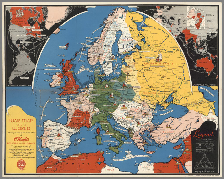
Author
Turner, Stanley
Full Title
War map of the world : specially executed by Stanley Turner A.R.C.A. for O'Keef's Beverages Limited, Toronto. Conic Projection. Copyright C.C. Petersen Advertising, 57 Queen St. W., Toronto. (Western hemisphere. Part of the Eastern hemisphere). British & French empires in Africa.
Publisher
C.C. Petersen Publishing and Advertising
Author
Magnus, Charles
Full Title
Panorama Of The Mississippi Valley And Its Fortifications. Published by C. Magnus, 12 Frankfort Street, New York. Eng. by F.W. Boell.
Publisher
Charles Magnus
Author
Magnus, Charles
Full Title
One Hundred & Fifty Miles Around Richmond. Charles Magnus' New York Printing Establishment - Offices: 12 Frankfort St., New York, and 520 7th St. Washington, D.C. Eleventh Edition 3000 of Magnus' all around Map ... Battle Ground of the Wilderness and Spottsylvania Court House. May, 5-23, 1864. Price 50 Cents. (with 9 small maps) Memphis And Nashville, Tenn. 225 Miles Around Vicksburg, Miss. 250 Miles Around Galveston, Texas. 200 Miles Around Montgomery, Ala. 100 Miles Around Milledgeville, Ga. Fortifications Around Richmond, Va. 250 Miles Around Charleston, S.C. 100 Miles Around Chattanooga, Tenn. Knoxville, Tenn., Danville, Ky. And Parkersburg, Va.
Publisher
Charles Magnus
Author
Mallory, C.A.
Full Title
Part of the North Bank of the Rappahannock River showing the approaches to Fredericksburg, prepared under the direction of Capt. R.S. Williamson & 1st Lt. Nicholas Bowen ... for the use of the Army of the Potomac compiled by Fred. Churchill Vol. A.D.C. U.S. Coast Survey Chart of the Rappahannock River Surveys and Reconnoissances by C.A. Mallory, Chas. Shoemacker, L.C. Oswell, H.H. Marvin, Geo. F. Lathrop, Assistants. Drawn by C.A. Mallory. Reduced and photographed by L.E. Walker, Treasy. Dept.
Publisher
U.S. Treasury Dept.
Author
Matz, Otto H.
Full Title
Map Of The Country Between Monterey, Tenn. & Corinth, Miss. showing The Lines Of Entrenchments Made & The Routes Followed by The U.S. Forces under the Command of Maj. Genl. Halleck, U.S. Army, In Their Advance Upon Corinth, In May 1862: Surveyed under the direction of Col Geo. Thom, A.D.C. & Chief Of Topl Engrs. Department Of The Mississippi, by Lieuts. Fred. Schraag and C.L. Spangenberg Asst. Topl. Engrs. and drawn by Lieut. Otto H. Matz Asst. Topl. Engr. Lith of J. Bien, 180 Broadway N.Y.
Publisher
J. Bien
Author
Spangenberg, Charles
Full Title
Map Of The Siege Of Vicksburg, Miss. By the U.S. Forces Under The Command Of Maj. Genl. U.S. Grant, U.S. Vls. ... Surveyed and constructed under the direction of Capt. C.B. Comstock ... by Major Otto H. Matz ... Chs. Spangenberg ... Drawn by Chs. Spangenberg ... Engr. on stone by J. Schedler No. 120 Pearl St. N.Y. Head Qrs. Of The Dept. Of The Tenn. Vicksburg Miss. Aug. 20th 1863. C.B. Comstock ...
Publisher
J. Schedler
Author
Weyss, John E.
Full Title
Military Map showing the topographical features of the country adjacent to Harper's Ferry Va. including Maryland, Loudoun, and Bolivar Heights, and portions of South and Short Mountains, with the positions of the Defensive Works, also the Junction of the Potomac & Shenandoah Rivers, and their passage through the Blue Ridge. Surveyed from August 3d to Sept. 30th 1863 Under The Direction Of Capt. N. Michler, Corps of Engrs U.S. Army By Major John E. Weyss, Principal Assistant, Engineer Department, Army Of The Potomac ...
Publisher
Engr. Dept U.S. Army
|