|
|
REFINE
Browse All : Mining of Pennsylvania
1-9 of 9
Author
[Strauch, Geo. B., Cochran, A.B.]
Full Title
(Covers to) The Anthracite Coal Fields Of Pennsylvania With Their Outlets To Market. By Geo. B. Strauch And A.B. Cochran, Mining Engineers, Pottsville, Pa. 1878. Entered ... 1878 by Strauch & Cochran ... Washington D.C. T. Sinclair & Son. lith. Phila. (inset) Anthracite Coal Fields And Their Outlets To Market. Strauch & Cochran 1878
Publisher
T. Sinclair & Son Lith.
Author
[Strauch, Geo. B., Cochran, A.B.]
Full Title
The Anthracite Coal Fields Of Pennsylvania With Their Outlets To Market. By Geo. B. Strauch And A.B. Cochran, Mining Engineers, Pottsville, Pa. 1878. Entered ... 1878 by Strauch & Cochran ... Washington D.C. T. Sinclair & Son. lith. Phila. (inset) Anthracite Coal Fields And Their Outlets To Market. Strauch & Cochran 1878
Publisher
T. Sinclair & Son Lith.
Author
[Smith, J.L., Smith, A. DW.]
Full Title
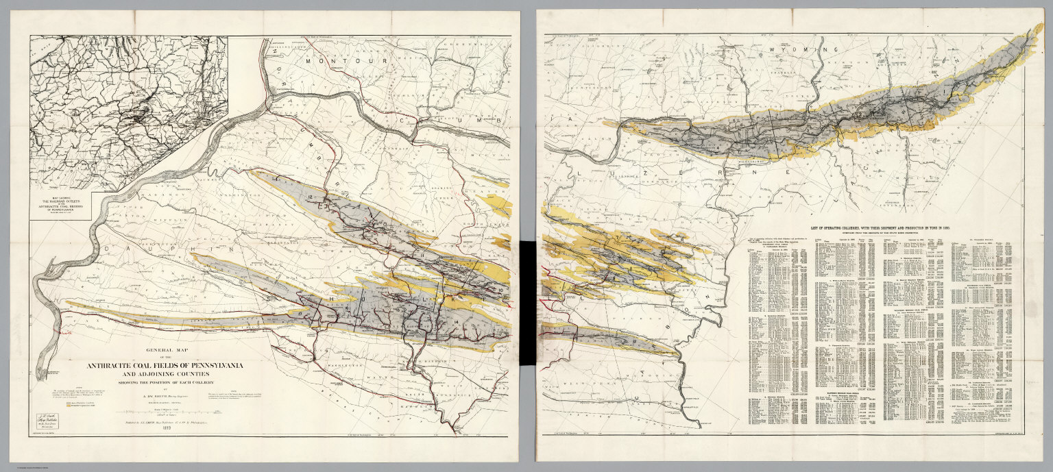
(Covers to) General Map Of The Anthracite Coal Fields Of Pennsylvania And Adjoining Counties Showing The Position Of Each Colliery. By A. DW. Smith, Mining Engineer. Wilkes-Barre, Penna. Published by J.L. Smith, Map Publisher, 27 S. 6th St., Philadelphia 1899. Copyrighted 1899 By A. DW. Smith. (inset) Map Showing The Railroad Outlets Of The Anthracite Coal Regions Of Pennsylvania.
Publisher
J.L. Smith
Author
[Smith, J.L., Smith, A. DW.]
Full Title
General Map Of The Anthracite Coal Fields Of Pennsylvania And Adjoining Counties Showing The Position Of Each Colliery. By A. DW. Smith, Mining Engineer. Wilkes-Barre, Penna. Published by J.L. Smith, Map Publisher, 27 S. 6th St., Philadelphia 1899. Copyrighted 1899 By A. DW. Smith. (inset) Map Showing The Railroad Outlets Of The Anthracite Coal Regions Of Pennsylvania.
Publisher
J.L. Smith
Author
[Smith, J.L., Smith, A. DW.]
Full Title
(Composite of) General Map Of The Anthracite Coal Fields Of Pennsylvania And Adjoining Counties Showing The Position Of Each Colliery. By A. DW. Smith, Mining Engineer. Wilkes-Barre, Penna. Published by J.L. Smith, Map Publisher, 27 S. 6th St., Philadelphia 1899. Copyrighted 1899 By A. DW. Smith. (inset) Map Showing The Railroad Outlets Of The Anthracite Coal Regions Of Pennsylvania.
Publisher
J.L. Smith
Author
Lee, Alex. Y.
Full Title
(Covers to) Lee's Map Of The Industries Of Western Pennsylvania. No. 1, being an Indexed Map Of The Connellsville Coke Field and Pittsburgh Gas Coal Beds, also showing the Various Transportation Lines traversing this field and centering at Pittsburgh, Pa. In connection with this map is issued A Detailed Map No.2 of Pittsburgh. Copyright 1884 by Alex. Y. Lee C.E. Pittsburgh, Pa. ... The Railway Map and Publishing Co. 88 Warren St. New York.
Publisher
: The Railway Map and Publishing Co.
Author
Lee, Alex. Y.
Full Title
Lee's Map Of The Industries Of Western Pennsylvania. No. 1, being an Indexed Map Of The Connellsville Coke Field and Pittsburgh Gas Coal Beds, also showing the Various Transportation Lines traversing this field and centering at Pittsburgh, Pa. In connection with this map is issued A Detailed Map No.2 of Pittsburgh. Copyright 1884 by Alex. Y. Lee C.E. Pittsburgh, Pa. ... The Railway Map and Publishing Co. 88 Warren St. New York.
Publisher
: The Railway Map and Publishing Co.
Author
[Hitchcock, Charles H. (Charles Henry), 1836-1919, United States. Census Office, Walker, Francis Amasa, 1840-1897]
Full Title
Map of the coal fields of the United States, compiled from state reports and data specially furnished by Prof. W.B. Rogers, E.T. Cox, A.H. Worthen, S.S. Lyon, Richard Owen, A.B. Roessler, R.P. Rothwell, Jas. MacFarlane, G.C. Swallow and W.C. Kerr, by Charles Hitchcock. To which are added the statistics of coal product for the years ending June 1st compiled from the statistics of industry, ninth census, 1870 by Francis A. Walker. (with) Map of the first and second anthracite coal fields of Pennsylvania. (Julius Bien, Lith., 1874)
Publisher
U.S.
Author
[Gray, Ormando Willis, Walling, H. F.]
Full Title
Map of Pennsylvania showing the principal deposits of iron, anthracite coal, petroleum and zinc. Engraved by W.S. Barnard, N.Y. (Published by Stedman, Brown & Lyon, Philadelphia, 1872)
Publisher
Stedman, Brown & Lyon
1-9 of 9
|