Who What Where WhenREMOVEWHO
WHEN
|
Full Title
The World. J.W. Barber sc. (with) A view of the comparative lengths of the principal rivers ... (with) Table of the comparative heights of the principal mountains in the world. (Published by Richardson & Lord. Sold also by Collins & Hannay, New-York, 1828)
Publisher
Richardson & Lord
Author
Thomson, John
Full Title
A comparative view of the heights of the principal mountains and other elevations in the World. Drawn & engraved for Thomson's New general atlas by W. & D. Lizars, Edinburgh. (1817)
Publisher
[Baldwin, Cradock, and Joy, John Cumming, John Thomson]
Author
[Bory de Saint-Vincent, M. (Jean Baptiste GeneviFve Marcellin), 1778-1846, Desmarest, Nicolas, 1725-1815, Vincent]
Full Title
Carte des montagnes coupees par des rivieres, situees en Virginie et en Pensylvanie. Grave par Berthe. (A Paris, Chez Mme. veuve Agasse, Imprimeur-Libraire, rue des Poitevins, no. 6. M.DCCCXXVII)
Publisher
Veuve Agasse
Author
[Bory de Saint-Vincent, M. (Jean Baptiste GeneviFve Marcellin), 1778-1846, Desmarest, Nicolas, 1725-1815, Vincent]
Full Title
Plan du Mont Gibel, anciennement Mont Etna. (with) Isole di Lipari. (with) Coupe du Mont Etna. (A Paris, Chez Mme. veuve Agasse, Imprimeur-Libraire, rue des Poitevins, no. 6. M.DCCCXXVII)
Publisher
Veuve Agasse
Author
[Bory de Saint-Vincent, M. (Jean Baptiste GeneviFve Marcellin), 1778-1846, Desmarest, Nicolas, 1725-1815, Vincent]
Full Title
Carte du Monte Vesuve. Grave par Ambroise Tardieu. (A Paris, Chez Mme. veuve Agasse, Imprimeur-Libraire, rue des Poitevins, no. 6. M.DCCCXXVII)
Publisher
Veuve Agasse
Author
[Bory de Saint-Vincent, M. (Jean Baptiste GeneviFve Marcellin), 1778-1846, Desmarest, Nicolas, 1725-1815, Vincent]
Full Title
Partie orientale de l'ile de Mascareigne. Grave par Ambroise Tardieu. (A Paris, Chez Mme. veuve Agasse, Imprimeur-Libraire, rue des Poitevins, no. 6. M.DCCCXXVII)
Publisher
Veuve Agasse
Author
[Bory de Saint-Vincent, M. (Jean Baptiste GeneviFve Marcellin), 1778-1846, Desmarest, Nicolas, 1725-1815, Vincent]
Full Title
Champs Phlegreens. Grave par Ambroise Tardieu. (A Paris, Chez Mme. veuve Agasse, Imprimeur-Libraire, rue des Poitevins, no. 6. M.DCCCXXVII)
Publisher
Veuve Agasse
Author
[Huntington, Francis Junius, 1802-1878, Huntington, Hezekiah, 1795-1865]
Full Title
Height of the principal mountains on the globe. Length of the principal rivers on the globe. Chart, exhibiting the comparative extent of oceans, continents, countries, islands, seas, and lakes. Entered ... 12th day of August, 1830 by H. & F.J. Huntington ... Connecticut.
Publisher
F.J. Huntington
Author
Lizars, Daniel
Full Title
Table of mountain chains: together with the altitudes of their principal summits. (with view) Culminating points & mean height of the principal chains of mountains of Europe, America & Asia, with the lower limit of perpetual snow in different latitudes. (Published by D. Lizars, Edinburgh. 1831?)
Publisher
[John Hamilton, W. Curry, Jun. & Co., Whittaker, Treacher & Co.]
Author
Lizars, Daniel
Full Title
Table of mountain chains: together with the altitudes of their principal summits. (Published by D. Lizars, Edinburgh. 1831?)
Publisher
[John Hamilton, W. Curry, Jun. & Co., Whittaker, Treacher & Co.]
Full Title
Western Hemisphere. Copyright 1887 by Wm. M. Bradley & Bro. (1890)
Publisher
John Y. Huber & Co.
Full Title
Eastern Hemisphere. Copyright 1887 by Wm. M. Bradley & Bro. (1890)
Publisher
John Y. Huber & Co.
Full Title
Western and Eastern Hemispheres. (with) Hemisphere containing greatest amount of water. (with) River systems of the World. (with) Hemisphere containing greatest amount of land. (Published at the office of "The Times," London, 1895)
Publisher
The Times
Full Title
Karte des Weltverkehrs und der Meeresstromungen in Mercators Projektion. (with) Schematisches Profil einiger Haupt-Berggipfel der Erde. (Richard Andree. Herausgegeben von der Geographischen Anstalt von Velhagen & Klasing in Leipzig. 1881)
Publisher
Velhagen & Klasing
Full Title
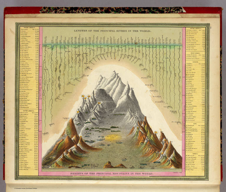
Comparative lengths of the principal rivers throughout the World. Comparative view of mountains. (1829)
Publisher
Collins & Hannay
Author
Clouet, J. B. L. (Jean-Baptiste Louis), b. 1730
Full Title
Lacs, fleuves, rivieres et principales montagnes d'Europe. Introduction. (1787)
Publisher
Mondhare et Jean
Author
Clouet, J. B. L. (Jean-Baptiste Louis), b. 1730
Full Title
Lacs, fleuves, rivieres et principales montagnes de l'Asie. Introduction. (1787)
Publisher
Mondhare et Jean
Author
Clouet, J. B. L. (Jean-Baptiste Louis), b. 1730
Full Title
Lacs, fleuves, rivieres et principales montages. de l'Afrique. Introduction. (1787)
Publisher
Mondhare et Jean
Author
Clouet, J. B. L. (Jean-Baptiste Louis), b. 1730
Full Title
Lacs, fleuves, rivieres et principales montagnes de l'Amerique. Introduction. (1787)
Publisher
Mondhare et Jean
Full Title
Comparative heights of mountains. (Boston: Hilliard, Gray, Little and Wilkins, 1826)
Publisher
Hilliard, Gray, Little and Wilkins
Full Title
L'Europe avec trois mers, trois fleuves & trois chaines de montagnes qui sont comunes a plus d'un pays. (1693)
Publisher
No Publisher
Full Title
L'Europe (avec trois mers, trois fleuves & trois chaines de montagnes qui sont comunes a plus d'un pays. 1693)
Publisher
No Publisher
Author
Mitchell, Samuel Augustus
Full Title
Western Hemisphere. Entered ... 1879 by S. Augustus Mitchell ... Washington. (1880)
Publisher
S.A. Mitchell
Author
Mitchell, Samuel Augustus
Full Title
Eastern Hemisphere. Entered ... 1879 by S. Augustus Mitchell ... Washington. (1880)
Publisher
S.A. Mitchell
Author
Fenner, Rest.
Full Title
A comparative view of the heights of the principal mountains and lengths of the principal rivers of the World. Fenner Sc., Paternoster Row. (London, Joseph Thomas, 1835)
Publisher
Joseph Thomas
Author
Lucas, Fielding Jr.
Full Title
Comparative Height of the Principal Mountains and other Elevations in the World. J. Cone Sc. Published by F. Lucas Jr. Baltimore.
Publisher
Fielding Lucas Jr.
Author
[Boue, Ami, 1794-1881, Johnston, Alexander Keith, 1804-1871]
Full Title
The geological structure of the globe according to Ami Boue, with corrections and additions to 1855. By A.K. Johnston, F.R.G.S. Engraved by W. & A.K. Johnston. William Blackwood & Sons, Edinburgh & London, (1856)
Publisher
William Blackwood & Sons
Author
Johnston, Alexander Keith, 1804-1871
Full Title
Comparative views of remarkable geological phenomena by A.K. Johnston, F.R.G.S. Engraved by W. & A.K. Johnston. William Blackwood & Sons, Edinburgh & London. (1856)
Publisher
William Blackwood & Sons
Author
[Berghaus, Heinrich, Johnston, Alexander Keith, 1804-1871]
Full Title
The river systems of Asia & Europe, showing the boundaries and comparative extent of the river basins & the oceans to which they contribute their waters. Extended from the original designs of Professor Berghaus, Berlin. By A.K. Johnston, F.R.G.S. Engraved by W. & A.K. Johnston. William Blackwood & Sons, Edinburgh & London. (1856)
Publisher
William Blackwood & Sons
Author
[Berghaus, Heinrich, Johnston, Alexander Keith, 1804-1871]
Full Title
The river systems of America, extended from the designs of Professor Berghaus, with additions of detailed maps of some of the principal hydrographical phenomena of the New World by A.K. Johnston, F.R.G.S. Corrected to 1855. Engraved by W. & A.K. Johnston. William Blackwood & Sons, Edinburgh & London. (1856)
Publisher
William Blackwood & Sons
Author
Greenleaf, Moses, 1777-1834
Full Title
Vertical sections, exhibiting the comparative altitudes of the principal highlands and rivers of the State of Maine. By Moses Greenleaf 1828. Engraved by W. Chapin for Greenleaf's Survey of Maine. Published by Shirley & Hyde, Portland, 1829.
Publisher
Shirley & Hyde
Author
[Darton, William, Gardner, W.R.]
Full Title
(Covers to) New and Improved View of the Comparative Heights of the Principal Mountains and Lengths of the Principal Rivers In The World, The whole Judiciously arranged from the various Authorities Extant. By W.R. Gardner. London: William Darton, 58 Holborn Hill, 10 Mo. 23rd, 1823. W.R. Gardner Sculpt. 367 Strand.
Publisher
William Darton
Author
Stieler, Adolf
Full Title
Fluss Und Bergkarte Von Deutschland Und Den Anliegenden Landern entworfen u. gez. von Adolf Stieler 1820. Neue vermehrte Auflage durch Herm. Berghaus. 1857. Druck von C. Hellfarth in Gotha. Gotha: Justus Perthes 1873.
Publisher
Justus Perthes
Author
[Darton, William, Gardner, W.R.]
Full Title
New and Improved View of the Comparative Heights of the Principal Mountains and Lengths of the Principal Rivers In The World, The whole Judiciously arranged from the various Authorities Extant. By W.R. Gardner. London: William Darton, 58 Holborn Hill, 10 Mo. 23rd, 1823. W.R. Gardner Sculpt. 367 Strand.
Publisher
William Darton
Author
[Andriveau-Goujon, J., Bruguiere, Louis]
Full Title
Tableau comparatif de la forme et de la hauteur des principales montagnes du globe terrestre, dedie a Monsieur le Baron, Alexdre. de Humboldt. A Paris, chez J. Andriveau-Goujon, Rue du Bac, no. 17. Par son tres humble et tres obeissant serviteur Louis Bruguiere. Grave par Ambroise Tardieu. (1850)
Publisher
J. Andriveau-Goujon
Author
Mitchell, Samuel Augustus
Full Title
Heights Of The Principal Mountains In The World. Lengths Of The Principal Rivers In The World. F. Humphrys. Sculpt. Entered ... 1846, H.N. Burroughs ... Pennsylvania.
Publisher
S.A. Mitchell
Author
Codazzi, Agustin, 1793-1859
Full Title
(Un cuadro de alturas que comprende las de las cordilleras de Merida, de la costa de Caracas, Coro, Cumana y Margarita, y ultimamente las del sistema de la Parima. Otro cuadro comparativo de la superficie y poblacion de cada provincia. Otro de los principales rios que banan el territorio venezolano, ora procedentes de sus sistemas de montanas, ora de los Andes granadinos, o de la serrania de la Parima) Lith. de Thierry, freres, Paris. (Caracas 1840)
Publisher
[Agostino Codazzi, Thierry Freres.]
Author
Garcia Cubas, Antonio, 1832-1912
Full Title
Carta Orografica. VI. A. Garcia Cubas. Propiedad De Los Editores. Publicado por Debray Sucesores - Mexico.
Publisher
Debray Sucesores
Author
Berghaus, Heinrich
Full Title
Die Isothermkurven Der Nordlichen Halbkugel. 1ste. Abtheilung: Meteorologie No. 2. Gezeichnet v. Bar, Berghaus, u. Schelle. In Potsdam Gestochen von K. Kolbe. Gotha, J. Perthes. 1838.
Publisher
Justus Perthes
Author
[Goujon, J, Andriveau, J.]
Full Title
Tableau Comparatif et Figure de La Hauteur des Principales Montagnes et du Cours des Principaux Fleuves due Monde. Les Fleuves graves par Dumortier. Les Montagnes par A. Hocquart. La Lettre par Arnoul. Paris. Chez J. Goujon & J. Andriveau. Geographes - Editeurs. Rue du Bac, No. 6, Pres le Pont Royal. 1836.
Publisher
Goujon, J.; Andriveau, J.
Author
Colton, G.W.
Full Title
Mountains & Rivers.
Publisher
J. H. Colton.
Author
Colton, G.W.
Full Title
(Text Page) Principal Rivers and Lakes in the World.
Publisher
J. H. Colton.
Author
Colton, G.W.
Full Title
(Index to) Principal Mountains in the World.
Publisher
J. H. Colton.
Author
Colton, G.W.
Full Title
(Text Page) Principal Rivers and Lakes in the World.
Publisher
G. W & C. B. Colton & Co.
Author
Colton, G.W.
Full Title
Mountains & Rivers. Published by G. W. & C. B. Colton & Co., No. 172 William St. New York.
Publisher
G. W & C. B. Colton & Co.
Author
Colton, G.W.
Full Title
(Index to) Principal Mountains in the World.
Publisher
G. W & C. B. Colton & Co.
Author
Martin de Moussy, V. (Victor), 1810-1869
Full Title
Coupes geologiques diverses - altitudes. Grave par Kautz, r. Bonaparte 82 - Paris. Paris - Imp. Lemercier, r. de Seine 57. (Paris Librairie de Firmin Didot Freres, Fils et Cie., 1873)
Publisher
Firmin Didot Freres.
Author
Martin de Moussy, V. (Victor), 1810-1869
Full Title
Coupes orographiques des parties centrales du territoire Argentin, de 260 a 330 L.S. Grave par Kautz, r. Bonaparte 82 - Paris. Paris - Imp. Lemercier, r. de Seine 57. (Paris Librairie de Firmin Didot Freres, Fils et Cie., 1873)
Publisher
Firmin Didot Freres.
Author
Martin de Moussy, V. (Victor), 1810-1869
Full Title
No. 1. Coupes du continent Sud Americain entre les Oceans Atlantique et Pacifique en moyenne sous le 33eme. de latitude en passant par l'extremite Sud du Massif central Argentin et la Cordillere de Mendoza. No. 2. Coupe sous le 40eme. parallele entre Valdivia et le Carmen pres l'embouchure du Rio Negro. No. 3. Coupe sous le 41eme. entre le Port Montt et le Carmen par le Lac de Nahuel-Huapi et le Rio Negro. Grave par Kautz, r. Bonaparte 82 - Paris. Paris - Imp. Lemercier, r. de Seine 57. (Paris Librairie de Firmin Didot Freres, Fils et Cie., 1873)
Publisher
Firmin Didot Freres.
|