|
|
REFINE
Browse All : Mountains/Rivers
1-36 of 36
Author
Mitchell, Samuel Augustus
Full Title
Lengths Of The Principal Rivers In The World. Heights Of The Principal Mountains In The World. Entered ... 1850, by Thomas, Cowperthwait & Co. ... Pennsylvania. Humphreys, F. Sculpt.
Publisher
Thomas, Cowperthwait & Co.
Author
[Thomson, John, Wyld, James, 1790-1836]
Full Title
Table of the Comparative Heights of the Principal Mountains of the World. (inset) Passes of the Alps, above the level of the sea. (to accompany) A General Atlas, Containing Maps illustrating some important periods in Ancient History; and distinct Maps of the several Empires, Kingdoms and States In The World, From Original Drawings according to the latest Treaties by J. Wyld and Engraved by N.R. Hewitt. Edinburgh, Printed for John Thomson & Co for Baldwin, Cradock & Joy, London & John Cumming, Dublin.
Publisher
John Thomson
Author
Wyld, James, 1812-1887
Full Title
Table of the Comparative Heights of the Principal Mountains in the World. Compiled and Drawn in the Quarter Master Generals Department. By James Wyld. Published by James Wyld (Successor to Mr. Faden) Charing Cross East. (inset) Passes of the Alps above level of the sea. (to accompany) An Atlas of the World, Comprehending Separate Maps of its various Countries, Constructed & drawn from the latest Astronomical & Geographical Observations. By James Wyld, Geographer to Her Majesty and H. Late R.H. Prince Albert. London. Published by James Wyld (Successor to Mr. Faden) Charing Cross East. 1864.
Publisher
James Wyld
Author
Mitchell, Samuel Augustus
Full Title
Lengths of the Principal Rivers in the World. Heights of the Principal Mountains in the World. F. Humphrys. Sculpt.
Publisher
S.A. Mitchell
Author
Arrowsmith, Aaron Jr.
Full Title
(Text Page to) Lenghts of some of the principal rivers in the world. Hights of some of the principal mountains &c. in the world. Re- Published, Jany st. 1845, by G.F. Cruchley, Mapseller, 81 Fleet Street, London. (to accompany) Outlines Of The World. By A. Arrowsmith, Hydrographer to His Majesty. 1850.
Publisher
G.F. Cruchley
Author
[Andree, Richard, Times (London, England)]
Full Title
The Austrian Alps. (Published at the office of "The Times," London, 1900).
Publisher
The Office of The Times
Author
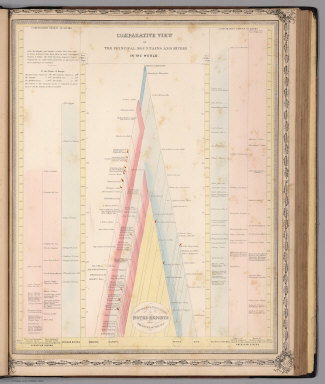
Lothian, John
Full Title
(View) Comparative View of the Principal Mountains and Rivers in the World.
Publisher
James MacLeod and Francis Orr & Sons
Author
Mitchell, Samuel Augustus
Full Title
(Frontispiece) Lengths of the Principal Rivers in the World. Heights of the Principal Mountains in the World.
Publisher
Thomas, Cowperthwait & Co.
Author
Mitchell, Samuel Augustus
Full Title
Lengths of the Principal Rivers in the World. Heights of the Principal Mountains in the World. F. Humphreys, Sculpt. Entered ... 1856 by Charles Desilver ... Pennsylvania.
Publisher
Charles DeSilver
Author
[Barbie du Bocage, J.G., Dufour, H.]
Full Title
(View) Hauteur au Dessus de la Mer, des Points les Plus Eleves ses Princip les. Chaines de Montagnes.
Publisher
Maison Basset
Author
Stieler, Adolf
Full Title
No.IX. Stieler's Hand-Atlas No. 10. Die bekannteren Hohwn uber der Meeresflache in Transparenten Profilen. (Mountains).
Publisher
Justus Perthes
Author
Stieler, Adolf
Full Title
No. XXIV. Stieler's Hand-Atlas (No. 18.) Fluss u. Berg-Karte von Deutschland. (River and Mountain Map of Germany).
Publisher
Justus Perthes
Author
[Codazzi, Agustín, 1793-1859, Paz, Manuel María, 1820-1902]
Full Title
Carta que representa el sistema orografico y las vertientes y hoyas hidrograficas de Colombia. Grabado por Erhard Hermanos, 8 Calle Nicole, Paris. (to accompany) Atlas geografico e historico de la Republica de Colombia (Antigua Nueva Granada).
Publisher
A. Lahure
Author
[Codazzi, Agustín, 1793-1859, Paz, Manuel María, 1820-1902]
Full Title
Carta geologico de algunas montanas de Colombia. (with) Rios navegables que banan el territorio Colombiano. (with) Guadro del estado del globo en sus diferentes epocas. Grabado por Erhard Hermanos, 8 Calle Nicole, Paris. (to accompany) Atlas geografico e historico de la Republica de Colombia (Antigua Nueva Granada).
Publisher
A. Lahure
Author
Stieler, Adolf
Full Title
Die bekannteren Hohen uber der meeresflache in transprenten profilen; nach der geograph, Lage geordnet, mit Andentungdes zusammenhanges u. der Entfernung vom Auge, Ein Versuch v. Ad. St. 1821. Die Schrift gest.v. E.G. Edler in Gotha. (on upper right margin) Stielers Hand Atlas. No. 10. (to accompany) Hand-Atlas uber alle Theile der Erde, nach dem neuesten Zustande und uber das Weltgebaude.
Publisher
Justus Perthes
Author
Stieler, Adolf
Full Title
Europa, zur Ubersicht der Flussgebiete und Hohenzüge, entw. u. gez. v. Ad. St. 1819. C. Jattnig sc.(on upper right margin) Hand Atl. No. 11. (to accompany) Hand-Atlas uber alle Theile der Erde, nach dem neuesten Zustande und uber das Weltgebaude.
Publisher
Justus Perthes
Author
Stieler, Adolf
Full Title
Fluss- und Berg-Karte von Deutschland und den anliegenden Landern; entw. u. gez. v. Ad. St. 1820. Hasse sc. (upper right margin) Hand-Atl. No. 18. (to accompany) Hand-Atlas uber alle Theile der Erde, nach dem neuesten Zustande und uber das Weltgebaude.
Publisher
Justus Perthes
Author
Desjardins, Constant
Full Title
Vergleichendes Tableau der bedeutendsten Hoehen der Erde, von Prof. C. Desjardins. 4te Auflage. Munchen 1855. Zu haben in Wien bei Joseph Bermann am Graben (fur ganz Osterreich.), in Munchen bei May und Widmayer (fur Deutschland). Eigentum des Verfassers.
Publisher
[Joseph Bermann am Graben, May und Widmayer]
Author
Stieler, Adolf
Full Title
No.IX. Stieler's Hand-Atlas No. 10. Die bekannteren Hohwn uber der Meeresflache in Transparenten Profilen. (Mountains).
Publisher
Justus Perthes
Author
Stieler, Adolf
Full Title
No. XXIV. Stieler's Hand-Atlas (No. 18.) Fluss u. Berg-Karte von Deutschland. (River and Mountain Map of Germany).
Publisher
Justus Perthes
Author
Bromme, Traugott
Full Title
24. Die bedeutendsten Hohen Deutschlands und der Schweiz. Entworfen von Tr. Bromme. Ausgefuhrt v. E. Winckelmann. Stuttgart. Verlag von Krais & Hoffman. (to accompany) Atlas zur Physik der Welt. (with second title page) Atlas zu Alex. v. Humboldt's Kosmos ... Bromme. (with 2 cross setions)
Publisher
Krais & Hoffman
Author
Stieler, Adolf
Full Title
No.IX. Stieler's Hand-Atlas No. 10. Die bekannteren Hohwn uber der Meeresflache in Transparenten Profilen. (Mountains).
Publisher
Justus Perthus
Author
Smith, C.
Full Title
Comparative View of the Lengths of the Principal Rivers in the World. London, Published by C. Smith Mapseller No. 172 Strand, Oct. 1st.1817. The Hills &c. by Palmer_The Writing by Gardner.
Publisher
C. Smith
Author
Smith, C.
Full Title
Comparative View of the Heights of the Principal Mountains &c. in the World. London, Published by C. Smith Mapseller, No.172 Strand, Augt. 1st. 1816. Gardner, Sculpt. (Third Edition)
Publisher
C. Smith
Author
Moule, Thomas
Full Title
A comparative view of some of the principal hills in Great Britain. " Hills peep o"er Hills and Alps o"er Alps arise". (by Thomas Moule).
Publisher
No Publisher
Author
C. Smith & Son
Full Title
A Comparative Picture of the Principal Waterfalls in the World. London. C. smith & Son. 172 Strand. 1836.
Publisher
C. Smith & Son
Author
Bradford, Thomas G.
Full Title
(Text Page to) Mountains. (to accompany) A Comprehensive Atlas, Geographical, Historical & Commercial. By T.G. Bradford. William D. Ticknor, Boston. Wiley & Long, New-York. Entered ... 1835, by Thos. G. Bradford ... Massachusetts.
Publisher
[William D. Ticknor, Wiley & Long]
Author
Bradford, Thomas G.
Full Title
Comparative heights of mountains. (to accompany) A Comprehensive Atlas, Geographical, Historical & Commercial. By T.G. Bradford. William D. Ticknor, Boston. Wiley & Long, New-York. Entered ... 1835, by Thos. G. Bradford ... Massachusetts.
Publisher
[William D. Ticknor, Wiley & Long]
Author
Bradford, Thomas G.
Full Title
Comparative lengths of rivers. (inset) Distribution of vegetables, and snow line. (to accompany) A Comprehensive Atlas, Geographical, Historical & Commercial. By T.G. Bradford. William D. Ticknor, Boston. Wiley & Long, New-York. Entered ... 1835, by Thos. G. Bradford ... Massachusetts.
Publisher
[William D. Ticknor, Wiley & Long]
Author
Bradford, Thomas G.
Full Title
(Text Page to) Rivers. (to accompany) A Comprehensive Atlas, Geographical, Historical & Commercial. By T.G. Bradford. William D. Ticknor, Boston. Wiley & Long, New-York. Entered ... 1835, by Thos. G. Bradford ... Massachusetts.
Publisher
[William D. Ticknor, Wiley & Long]
Author
Bradford, Thomas G.
Full Title
(Text Page to) Classification and geographical distribution of animals. (to accompany) A Comprehensive Atlas, Geographical, Historical & Commercial. By T.G. Bradford. William D. Ticknor, Boston. Wiley & Long, New-York. Entered ... 1835, by Thos. G. Bradford ... Massachusetts.
Publisher
[William D. Ticknor, Wiley & Long]
Author
Gray, O.W.
Full Title
Mountains and Rivers.
Publisher
Stedman, Brown & Lyon
Author
Weiland, Carl Ferdinand (1782-1847)
Full Title
Hohen Charte oder bildlich vergleichende Ubersicht der bedeutendsten Berge in Europa, Asien, Africa, America, und den Sudsee Landern. (Entworfen von CF Weiland). Weimar, Verlag des Geographischen Institutes, 1820.
Publisher
Geographisches Institut
Author
Weiland, Carl Ferdinand (1782-1847)
Full Title
Hohen Charte oder bildlich vergleichende Uebersicht der bedeutendesten Berge in Teutschland und der Schweiz nebst Andeutung der Hohen vieler Stadte, Dorfer, Seen etc. nach den besten Barometermessungen entworfen von CF Weiland. Weimar, Verlag des Geographischen Institutes, 1821. Gravirt v. Anton Falger.
Publisher
Geographisches Institut.
Author
Finley, Anthony
Full Title
Map of Florida, According to the Latest Authorities. Comparative Elevation of the Principal Mountains, Cities, &c. in North & South America.
Publisher
Anthony Finley
Author
[Drioux, Claude-Joseph, Leroy, Charles]
Full Title
France : Hypsometrique : Relief du sol. Par M.Mrs. Drioux et Ch. Leroy. Dessine par Vilpou. ... Grave par F. Dufour. Librairie Classique Eugene Belin Paris. (inset) Corse. (to accompany) Atlas Universel Et Classique De Geographie ...1886. (insets) France geologique . (with inset) Corse; Coupe ideale de l'ecorce terrestre.
Publisher
Eugene Belin
1-36 of 36
|