Browse All

1853 Principal Rivers and Mountains of the Wo … World Atlas Lengths Of The Principal Rivers In The W … |

1824 Table of the Comparative Heights of the … World Atlas Table of the Comparative Heights of the … |

1864 Table of the Comparative Heights of the … World Atlas Table of the Comparative Heights of the … |

1849 Principal Rivers and Mountains of the Wo … World Atlas Lengths of the Principal Rivers in the W … |

1845 Text: Principal rivers and mountains in … World Atlas (Text Page to) Lenghts of some of the pr … |

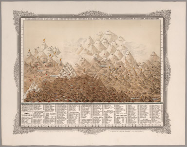
1900 The Austrian Alps World Atlas The Austrian Alps. (Published at the off … |
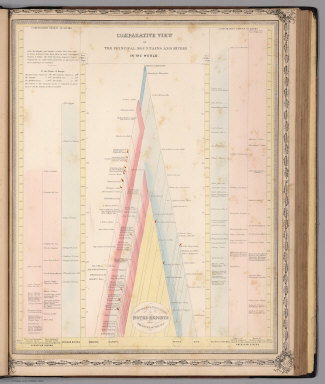
1848 View: Comparative View of the Principal … World Atlas (View) Comparative View of the Principal … |

1850 Frontispiece: Lengths of the Principal R … World Atlas (Frontispiece) Lengths of the Principal … |

1857 Lengths of the Principal Rivers, Heights … World Atlas Lengths of the Principal Rivers in the W … |

1852 View: Hauteur au Dessus de la Mer, les C … World Atlas (View) Hauteur au Dessus de la Mer, des … |

1852 Die bekannteren Hohwn uber der Meeresfla … World Atlas No.IX. Stieler's Hand-Atlas No. 10. Die … |

1846 Fluss u. Berg-Karte von Deutschland. (Ri … World Atlas No. XXIV. Stieler's Hand-Atlas (No. 18.) … |

1889 Carta que representa el sistema orografi … National Atlas Carta que representa el sistema orografi … |

1889 Carta geologico de algunas montanas de C … National Atlas Carta geologico de algunas montanas de C … |

1821 Die bekannteren Höhen über der Meeresfla … World Atlas Die bekannteren Hohen uber der meeresfla … |

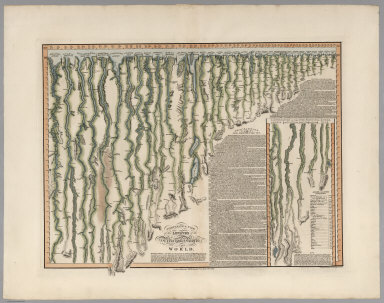
1819 Europa, zur Ubersicht der Flussgebiete u … World Atlas Europa, zur Ubersicht der Flussgebiete u … |

1820 Fluss- und Berg-Karte von Deutschland un … World Atlas Fluss- und Berg-Karte von Deutschland un … |
1855 Vergleichendes Tableau der bedeutendsten … Separate Map Vergleichendes Tableau der bedeutendsten … |

1850 Die bekannteren Hohwn uber der Meeresfla … World Atlas No.IX. Stieler's Hand-Atlas No. 10. Die … |

1846 Fluss u. Berg-Karte von Deutschland. (Ri … World Atlas No. XXIV. Stieler's Hand-Atlas (No. 18.) … |

1851 24. Die bedeutendsten Hohen Deutschlands … Physical Atlas 24. Die bedeutendsten Hohen Deutschlands … |

1837 Die bekannteren Hohwn uber der Meeresfla … World Atlas No.IX. Stieler's Hand-Atlas No. 10. Die … |
1817 Comparative View of the Lengths of the P … [Separate Map, View] Comparative View of the Lengths of the P … |
1816 Comparative View of the Heights of the P … [Separate Map, View] Comparative View of the Heights of the P … |

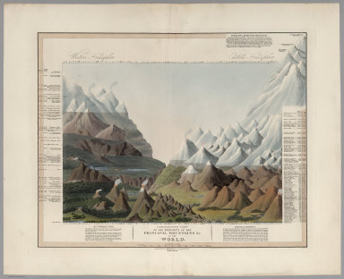
1837 A comparative view of some of the princi … View A comparative view of some of the princi … |

1836 A Comparative Picture of the Principal W … View A Comparative Picture of the Principal W … |

1838 Text Page: Mountains World Atlas (Text Page to) Mountains. (to accompany) … |

1838 Comparative heights of mountains World Atlas Comparative heights of mountains. (to ac … |

1838 Comparative lengths of rivers. Distribut … World Atlas Comparative lengths of rivers. (inset) D … |

1838 Text Page: Rivers World Atlas (Text Page to) Rivers. (to accompany) A … |

1838 Text Page: Classification and geographic … World Atlas (Text Page to) Classification and geogra … |

1873 Mountains and Rivers. World Atlas Mountains and Rivers. |

1820 Hohen Charte oder bildlich vergleichende … Separate Map Hohen Charte oder bildlich vergleichende … |

1821 Hohen charte Berge in Teutschland und de … Separate Map Hohen Charte oder bildlich vergleichende … |

1827 Florida. Principal Mountains, Cities, &c … National Atlas Map of Florida, According to the Latest … |

1886 France : Hypsometrique : Relief du sol World Atlas France : Hypsometrique : Relief du sol. … |