Who What Where WhenREMOVE |
REFINE
Browse All : National Atlas and Atlas Map and Rivers
1-24 of 24
Author
Jefferys, Thomas
Full Title
An Exact Chart of the River St. Laurence, from Fort Frontenac to the Island of Anticosti shewing the Soundings, Rocks, Shoals &c with Views of the Lands and all necessary Instructions for navigating that River to Quebec. To the Rt. Honble. Fn. Montagu El. of Sandwich, First Lord Commisioner to the other Honble. Commissioners for executing the Office of Lord High Admiral of Great Britain. This Chart is most Humbly Inscribed By their Lordships most Obedient most devoted Humble Servt. Thos. Jefferys. (with) Six inset maps [described in notes field]. London. Printed for Robt. Sayer ... 25 May, 1775.
Publisher
Sayer and Bennett
Author
Jefferys, Thomas
Full Title
Course Of The River Mississipi, from the Balise to Fort Chartres; Taken on an Expedition to the Illinois, in the latter end of the Year 1765. By Lieut. Ross of the 34th Regiment: Improved from the Surveys of that River made by the French. London Printed for Robt. Sayer ... 1 June 1775.
Publisher
Sayer and Bennett
Full Title
Carte des principales rivieres du globe. Grave par Le Gagneur, Rue du Marche-Neuf, No. 8. Fonderie et Imprimerie de J. Carez. (1825)
Publisher
J. Carez
Author
[Lizars, William Home, Thomson, John]
Full Title
A comparative view of the lengths of the principal rivers of Scotland. (with) Comparative view of the height of the falls of Foyers and Corba Linn. Drawn by W.H. Lizars. Engd. by W.H. Lizars. Published by John Thomson, Edinburgh, 1831. (1832)
Publisher
[Baldwin & Cradock, John Cumming, John Thomson & Co.]
Author
[Götz, Antonín, Československá akademie věd., Czechoslovakia. Ústřední správa geodézie a kartografie.]
Full Title
Road Network.
Publisher
Czechoslovakia. Ústřední správa geodézie a kartografie.
Author
[Canada. Department of Interior, Chalifour, J.E.]
Full Title
Drainage basins. (on upper right margin) Atlas of Canada. (to accompany) Department of the Interior Canada. Atlas Of Canada, 1915.
Publisher
Department of Interior
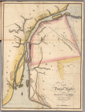
Author
Melish, John
Full Title
Map of Detroit River and Adjacent Country, From an Original Drawing, by a British Engineer.
Publisher
John Melish
Author
Ordnance Survey Office
Full Title
Stanford's Useful Maps, England, Outline Series No. 4. (Hydrography). Stanford's Outline Series. London. Edward Stanford, 12, 13 & 14 Long Acre, W.C.
Publisher
Ordnance Survey Office
Author
Codazzi, Agustin, 1793-1859
Full Title
Mapa fisico de Venezuela divida en hoyas hydrograficas. Mapa fisico de Venezuela dividida en tres zonas. Lith. de Thierry freres a Paris. (Caracas 1840)
Publisher
[Agostino Codazzi, Thierry Freres.]
Author
[Collot, George Henri Victor, Tardieu, P.F.]
Full Title
General Map of the Course of the Ohio from Its Source to its Junction With The Mississipi. PL. 2.
Publisher
Arthus Bertrand
Author
[Collot, George Henri Victor, Tardieu, P.F.]
Full Title
A General Map of the River Ohio, Plate the first. Grave par Tardieu l'aine. PL. 8.
Publisher
Arthus Bertrand
Author
[Collot, George Henri Victor, Tardieu, P.F.]
Full Title
A General Map of the River Ohio, Plate the second. Grave par Tardieu l'aine. PL. 9.
Publisher
Arthus Bertrand
Author
[Collot, George Henri Victor, Tardieu, P.F.]
Full Title
A General Map of the River Ohio, Plate the third. Grave par Tardieu l'aine. PL. 10.
Publisher
Arthus Bertrand
Author
[Collot, George Henri Victor, Tardieu, P.F.]
Full Title
A General Map Of The River Ohio, From its source to its mounth (sic): containing the names of the Towns Villages and Farms established at present on its banks: together with its soundings, and courses. Plate the fourth. Grave par Tardieu l'aine. PL. 11.
Publisher
Arthus Bertrand
Author
[Collot, George Henri Victor, Tardieu, P.F.]
Full Title
Plan of the Rapids or Falls of the Ohio Latitude of Louisville. Grave par Tardieu l'aine. PL. 17.
Publisher
Arthus Bertrand
Author
[Collot, George Henri Victor, Tardieu, P.F.]
Full Title
Passage of a Branch of the river Juniata across a chain of Mountains uninhabited and covered with Wood. Grave par Tardieu l'aine. PL. 23.
Publisher
Arthus Bertrand
Author
[Collot, George Henri Victor, Tardieu, P.F.]
Full Title
Map of the Course of The Mississippi from the Missouri and the Country of The Illinois to the mouth of this River. PL. 23.
Publisher
Arthus Bertrand
Author
Garcia Cubas, Antonio, 1832-1912
Full Title
Carta Hydrografica. VII. A. Garcia Cubas. Propiedad De Los Editores. Publicado por Debray Sucesores - Mexico.
Publisher
Debray Sucesores
Author
Martin de Moussy, V. (Victor), 1810-1869
Full Title
Carte du cours du Haut Uruguay depuis la Concepcion jusqu'aux frontieres Argentine et Bresilienne dans le Territoire extreme des Missions. 1ere. feuille. De la Ville de la Concepcion a celle de la Uruguayana. Par le Dr. V. Martin de Moussy, 1866. Grave par L. Kautz, r. Bonaparte 82 - Paris. Paris - Imp. Lemercier, r. de Seine 57. (Paris Librairie de Firmin Didot Freres, Fils et Cie., 1873)
Publisher
Firmin Didot Freres.
Author
Martin de Moussy, V. (Victor), 1810-1869
Full Title
Carte du cours du Haut Uruguay depuis la Concepcion jusqu'aux frontieres Argentine et Bresilienne dans le Territoire extreme des Missions. 2eme. feuille. De la Ville de la Uruguayana au Rio Pepiri-Guazu. Par le Dr. V. Martin de Moussy, 1866. Grave par Kautz, r. Bonaparte 82 - Paris. Paris - Imp. Lemercier, r. de Seine 57. (Paris Librairie de Firmin Didot Freres, Fils et Cie., 1873)
Publisher
Firmin Didot Freres.
Author
[Martin de Moussy, V. (Victor), 1810-1869, Page, Thomas Jefferson, 1808-1899]
Full Title
Cours inferieur et bouches du Rio Paraguay d'apres les reconnaissances du Commandant Thomas Page en 1853. Chutes du Rio Parana dites de Maracayu ou las Siete Caidas. Bouche et chutes de l'Y-Guazu. Grave par Kautz, r. Bonaparte 82, Paris. Paris. Imp. Lemercier, r. de Seine 57. (Paris Librairie de Firmin Didot Freres, Fils et Cie., 1873)
Publisher
Firmin Didot Freres.
Author
Paz Soldan, Mariano Felipe, 1821-1886
Full Title
Mapa orohidrografico de la Republica Argentina. Paz Soldan. Atlas geografico Argentino. Grabado por Erhard hermanos, 8 Calle Nicole, Paris. Imp. Erhard hermanos. Felix Lajouane, Editor, Buenos-Aires, 1888.
Publisher
Felix Lajouane, Editor.
Author
Melish, John
Full Title
Map of Detroit River and Adjacent Country, From an Original Drawing, by a British Engineer.
Publisher
John Melish
Author
[Maw, Henry Lister, Paz Soldan, Mariano Felipe, 1821-1886]
Full Title
Lecho del Rio Amazonas segun los sondeos de Lister Maw. Corte vertical del camino de Lima al Cerro de Pasco. Paz Soldan. Geografia del Peru. Grabado por Delamare, Calle St. Andre des Arts 45, Paris. Imp. Janson - Paris. (Paris: Libreria de Augusto Durand, 1865)
Publisher
Libreria de Augusto Durand.
1-24 of 24
|