Who What Where WhenREMOVEWHO
WHEN
|
Author
Great Britain. Ordnance Survey
Full Title
(Covers to) Ordnance Survey of Great Britain. New Popular One-Inch Map with National Grid, England and Wales. Volume 2 (of 4).
Publisher
Ordnance Survey of Great Britain
Author
Great Britain. Ordnance Survey
Full Title
(Covers to) Ordnance Survey of Great Britain. New Popular One-Inch Map with National Grid, England and Wales. Volume 3 (of 4).
Publisher
Ordnance Survey of Great Britain
Author
Great Britain. Ordnance Survey
Full Title
(Covers to) Ordnance Survey of Great Britain. New Popular One-Inch Map with National Grid, England and Wales. Volume 4 (of 4).
Publisher
Ordnance Survey of Great Britain
Author
Tanner, Henry S.
Full Title
(Covers to) A New Pocket Atlas of the United States With The Roads and Distances, Designed For the Use of Travelers. By H.S. Tanner. Philadelphia: Published by the Author. 1828. (on verso) ...on the seventeenth day of November ... 1828, Henry S. Tanner ... hath deposited ... a book ... Pennsylvania.
Publisher
H.S.Tanner
Author
[Conder, C.R. (Claude Reignier), Kitchener, H.R. (Horatio Herbert)]
Full Title
(Covers to) Map of Western Palestine in 26 Sheets from surveys conducted for the Committee of the Palestine Exploration Fund by Lieutenants C.R. Conder and H.H. Kitchener, R.E. During the Years 1872 - 1877. [Bound with] Map of West Palestine... Special Edition Illustrating The Old Testament, the Apocropha and Josephus... by Trelawney Saunders. [Bound with] Map of West Palestine... Special Edition Illustrating the New Testament also the Talmud and Josephus(after the Birth of Jesus)... [Bound with] Map of West Palestine... Reduced from the One Inch Map. [Bound with] Map of West Palestine... Special Edition Illustrating the Divisions of the Natural Drainage and the Mountain Ranges... by Trelawney Saunders. (Five works bound in in one; (main map) London: Committee of the Palestine Exploration Fund, 1880; (the other maps) London Edward Stanford, 1881-2.)
Publisher
Committee of the Palestine Exploration Fund
Author
General de Correos Seccion de Transportes.
Full Title
Cartas Postales de los Estados Unidos Mexicanos.
Publisher
General de Correos Seccion de Transportes
Author
[Morse, Sidney E., Breese, S.]
Full Title
(Covers to) Supplement To The New-York Observer. The Cerographic Atlas Of The United States. (No. 1). By Sidney E. Morse, A.M. And Samuel Breese, A.M. New-York: Published By Sidney E. Morse & Co. 1842. [Entered ... 1841, by Sidney E. Morse and Samuel Breese ... New-York.]
Publisher
Sidney E. Morse & Co.
Author
[Morse, Sidney E., Breese, S.]
Full Title
(Covers to) Supplement To The New-York Observer. The Cerographic Atlas Of The United States. (No.2). By Sidney E. Morse, A.M. And Samuel Breese, A.M. New-York: Published By Sidney E. Morse & Co. 1843.
Publisher
Sidney E. Morse & Co.
Author
[Morse, Sidney E., Breese, S.]
Full Title
(Covers to) Supplement To The New-York Observer. The Cerographic Atlas Of The United States. No.3. By Sidney E. Morse, A.M. And Samuel Breese, A.M. New-York: Published By Sidney E. Morse & Co. 1845. [Entered ... 1841, by Sidney E. Morse and Samuel Breese ... New-York.]
Publisher
Sidney E. Morse & Co.
Author
[Morse, Sidney E., Breese, S.]
Full Title
(Covers to) Morse's North American Atlas ... New York: Published By Harper & Brothers, 82 Cliff Street. Entered ... 1842, by Sidney E. Morse and Samuel Breese ... New York. (second illustrated title page) Morse's Cerographic Maps. Plan Of Publication ... Each number will contain four coloured Maps ... If practicable, from two to three numbers will be issued every month ... The first ten numbers will form a comprehensive and elegant North American Atlas for the Library, the Counting House, and the School room ... New-York. Harper And Brothers, 82 Cliff Street. 1845 ... Price 25 Cts.
Publisher
Harper and Brothers
Author
Finley, Anthony
Full Title
(Covers to) A New American Atlas, Designed Principally To Illustrate The Geography Of The United States Of North America; In Which Every County In Each State And Territory Of The Union Is Accurately Delineated, As Far As At Present Known: The Whole Compiled From The Latest And Most Authentic Information. Philadelphia: Published By Anthony Finley, At The North-East Corner Of Chestnut And Fourth Streets. 1826.
Publisher
Anthony Finley
Author
[Gray, Frank A., Gray, O.W.]
Full Title
(Covers to) The National Atlas. Containing Elaborate Topographical Maps Of The United States And The Dominion of Canada, With Plans Of Cities And General Maps Of The World. Also, Descriptions and Tables, Historical and Statistical ... Accompanied By Special, Railway, And Scientific Maps And Articles. Special Edition. Stedman & Brown, Publishers, No. 56 North Fourth Street, Philadelphia. Philadelphia: O.W. Gray & Son, Geographical Establishment, No. 56 North Fourth Street. 1884. (on verso) Copyright 1876, by O.W. Gray & Son. Entered ... 1882, by O.W. Gray & Son ... Washington.
Publisher
Stedman & Brown
Author
Cram, George Franklin
Full Title
(Covers to) Cram's Standard American Atlas Of The United States, Compiled from the very latest sources, showing Railroads, Rivers, Counties, Towns, Villages, Post Offices, Population, &c., to date. A Complete Guide For Business Men. Scale, 19 Miles to an Inch. Published By George F. Cram, Proprietor Of The Western Map Depot, 66 Lake Street, Chicago, Ill. 1878.
Publisher
George F. Cram
Author
General de Correos Seccion de Transportes.
Full Title
Cartas Postales de los Estados Unidos Mexicanos. 1908.
Publisher
General de Correos Seccion de Transportes
Full Title
(Covers to) (Carte de France. Levee par ordre du Roy. 1750-1815)
Publisher
Carte de la France Directeures
Author
[Rand McNally and Company, State Farm Insurance Companies Travel Bureau]
Full Title
(Cover Tittle to) State Farm road atlas : United States, Canada, Mexico, hotel, cabin camp guide. Published by: The State Farm Insurance Companies Travel Bureau, Bloomington, Illinois. Copyright 1939 by Rand McNally & Company, Chicago, Ill. Price $1.00 each.
Publisher
State Farm Insurance Companies Travel Bureau
Author
[Taylor, Frank J., White, Ruth Taylor]
Full Title
(Covers to) Our U.S.A. A Gay Geography. Text by Frank J. Taylor. Maps by Ruth Taylor. Boston - Little, Brown, and Company - 1935.
Publisher
Little, Brown, and Company
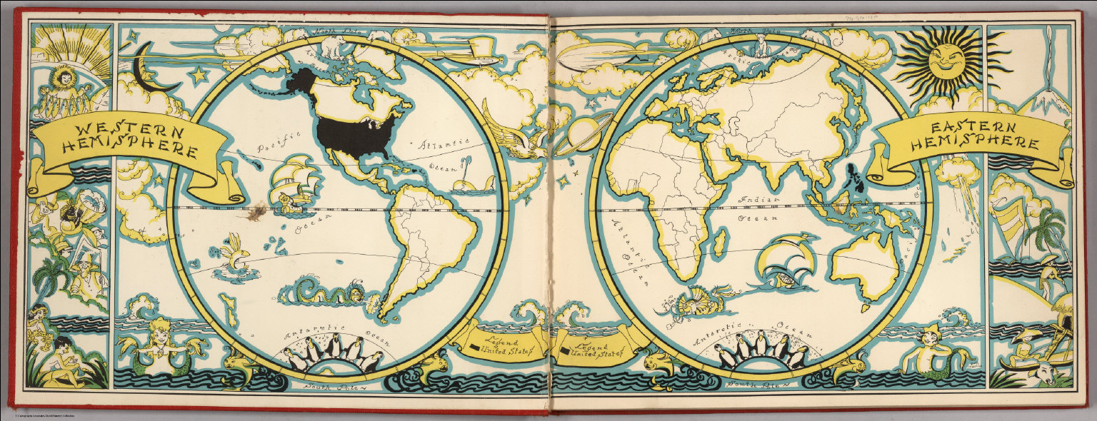
Author
[Taylor, Frank J., White, Ruth Taylor]
Full Title
(Liners of Front and Back Covers) (The Earth in Hemispheres).
Publisher
Little, Brown, and Company
Author
Codazzi, Agustin, 1793-1859
Full Title
(Covers to) Atlas fisico y politico de la Republica de Venezuela dedicado por su autor, el Coronel de Ingenieros Agustin Codazzi al Congreso Constituyente de 1830. Caracas 1840. Lith. de Thierry Fres. Cite Bergere 1 a Paris.
Publisher
[Agostino Codazzi, Thierry Freres.]
Author
Garcia Cubas, Antonio, 1832-1912
Full Title
(Covers to) Atlas geografico, estadistico e historico de la Republica Mexicana, formado por Antonio Garcia y Cubas. Mexico. Imprenta de Jose Mariano Fernandez de Lara, calle de la Palma numero 4. 1858.
Publisher
Imprenta de Jose Mariano Fernandez de Lara.
Author
Cary, John
Full Title
(Covers to) Cary's Survey of the High Roads From London to ... On a Scale of one Inch to a Mile; wherein Every Gentleman's Seat, situate on, or seen from the Road, (however distant) are laid down, with the name of the Possessor; to which is added The Number of Inns on each separate route; also, the different Turnpike Gates, shewing The Connection which one trust has with another. London: Printed for J. Cary, Engraver & Map seller, the corner of Arundel Street, Strand. July 1st, 1790.
Publisher
J. Cary
Author
Robert Sayer and John Bennett (Firm)
Full Title
(Covers to) The American Military Pocket Atlas; Being An approved Collection of Correct Maps, Both General and Particular, of The British Colonies; Especially those which now are, or probably may be The Theatre of War: Taken principally from the actual Surveys and judicious Observations of Engineers De Brahm and Romans; Cook, Jackson, and Collet; Maj. Holland, and other Officers, Employed in His Majesty's Fleets and Armies. London. Printed for R. Sayer and J. Bennet, Map and Print-Sellers (No. 53) Fleet-street.
Publisher
Sayer and Bennett
Author
Carey, Mathew
Full Title
(Covers to) Carey's American Atlas: Containing Twenty Maps And One Chart ... Philadelphia: Engraved For, And Published By, Mathew Carey, No. 118, Market Street. M.DCC.XCV. [Price, Plain, Five Dollars-Coloured, Six Dollars.]
Publisher
Mathew Carey
Author
Garcia Cubas, Antonio, 1832-1912
Full Title
(Covers to) Atlas Pintoresco E Historico De Los Estados Unidos Mexicanos Por Antonio Garcia Cubas ... Publicado Por Debray Sucesores Mexico 1885.
Publisher
Debray Sucesores
Author
Mitchell, Samuel Augustus
Full Title
(Covers to) A New American Atlas, Designed Principally To Illustrate The Geography Of The United States Of North America; In Which Every Country In Each State And Territory Of The Union Is Accurately Delineated, As Far As At Present Known: The Whole Compiled From The Latest And Most Authentic Information. Philadelphia: Published By Samuel Augustus Mitchell. 1831.
Publisher
S.A. Mitchell
Author
Arbuckle Bros.
Full Title
(Front cover to) Arbuckles' lllustrated Atlas of the United States of America. Copyright 1889, Arbuckle Bros. N.Y.
Publisher
Arbuckle Bros.
Author
Arbuckle Bros.
Full Title
(Back cover to) Arbuckles' lllustrated Atlas of the United States of America. Copyright 1889, Arbuckle Bros. N.Y.
Publisher
Arbuckle Bros.
Author
Martin de Moussy, V. (Victor), 1810-1869
Full Title
(Covers to) Description geographique et statistique de la Confederation Argentine par V. Martin de Moussy ... Deuxieme edition atlas. Paris Librairie de Firmin Didot Freres, Fils et Cie. Imprimeurs de l'Institut, Rue Jacob, 56. 1873. Imprimerie Adolphe Laine, Rue des Saints-Peres, 19.
Publisher
Firmin Didot Freres.
Author
Paz Soldan, Mariano Felipe, 1821-1886
Full Title
(Covers to) Atlas geografico del Peru, publicado a expensas del Gobierno Peruano, siendo Presidente el Libertador Gran Mariscal Ramon Castilla, por Mariano Felipe Paz Soldan ... Paris, Libreria de Augusto Durand, Calle de Gres-Sorbonne, 7. 1865. Paris. - Imprenta de Ad. Laine y J. Havard, Calle des Saints-Peres, No. 19.
Publisher
Libreria de Augusto Durand.
Author
Restrepo, Jose Manuel, 1781-1863
Full Title
(Covers to) Historia de la revolucion de la Republica de Colombia, por Jose Manuel Restrepo, Secretario del Interior del poder ejecutivo de la misma Republica. Atlas. Paris, Libreria Americana, Calle del Temple, no. 69. 1827.
Publisher
Libreria Americana
Author
Smith, J. Calvin
Full Title
(Covers to) Special-Karte Der Vereinicten Staaten Von Nord-Amerika. von J. Calvin Smith. Zweite verbesserte Auflage. Map Of The United States of America By J. Calvin Smith. Cassel, Druck und Verlag von Theodor Fischer.
Publisher
Theodor Fischer
Author
Finley, Anthony
Full Title
(Covers to) American Atlas (Pocket Atlas).
Publisher
Anthony Finley
Author
Paz Soldan, Mariano Felipe, 1821-1886
Full Title
(Covers to) Atlas geografico de la Republica Argentina que contiene los mapas de cada provincia, y los del Uruguay y Paraguay compuesto en presencia de los ultimos trabajos cientificos por D.M.F. Paz Soldan ... Nueva edicion corregida y aumentada. Buenos Aires, Felix Lajouane, Editor, Calle del Peru 51 y 53. 1888. (seal) Sine Labore Nihil. FL.
Publisher
Felix Lajouane, Editor.
Author
Baker, Oliver Edwin
Full Title
(Covers to) Atlas of American Agriculture. Physical Basis including Land Relief, Climate, Soils, and Natural Vegetation of the United States. Prepared under the Supervision of O.E. Baker, Bureau of Agricultural Economics. Contributions from the Weather Bureau, Willis R. Gregg, Chief; Bureau of Chemistry and Soils, H.G. Knight, Chief; Bureau of Plant Industry, Frederick D. Richey, Chief; Forest Service, F.A. Silcox, Chief; Bureau of Agricultural Economics, A.G. Black, Chief. United States Department of Agriculture, Washington, D.C., United States Government Printing Office, Washington: 1936.
Publisher
U.S. Department of Agriculture
Author
Pissis, Aime, 1812-1889
Full Title
(Covers to) Mapa de la Republica de Chile desde el rio Loa hasta el cabo de Hornos, por A. Pissis ... Lit. P. Cadot i Ca., Huerfanos, 25, (1884)
Publisher
P. Cadot.
Author
Rand McNally and Company
Full Title
(Covers to) Rand McNally Commercial Atlas Of America. Fifty-Fifth Edition ... Engraved, Printed, And Published By Rand McNally & Company, Chicago, U.S.A., 1924. (on verso) ... Copyright, 1924, by Rand, McNally & Co. Made In U.S.A.
Publisher
Rand McNally and Company
Author
[Bartholomew, John, Black, Adam & Charles]
Full Title
(Covers to) Black's Atlas Of North America. A Series Of Twenty Maps Constructed And Engraved By John Bartholomew. With Introductory Letter-Press And A Complete Index. Edinburgh: Adam And Charles Black. MDCCCLVI.
Publisher
A. & C. Black
Author
Cary, John, ca. 1754-1835
Full Title
(Covers to) Cary's New Map of England And Wales, With Part Of Scotland. On Which Are Carefully Laid Down All the Direct and Principal Cross Roads, the Course of the Rivers And Navigable Canals ... Delineated from Actual Surveys: and materially assisted From Authentic Documents Liberally supplied by the Right Honourable the Post Masters General. London: Published Jun 11th 1794 by J. Cary, Engraver & Map-seller, No. 181 Strand.
Publisher
John Cary
Author
Rand McNally and Company
Full Title
(Covers to) Rand McNally & Co.'s Enlarged Business Atlas And Shippers' Guide ... Together With A Complete Reference Map Of The World ... Accompanied By A New and Original Compilation and Ready Reference Index, Showing In Detail The Entire Railroad System ... Engraved, Printed, And Published By Rand, McNally & Company, Chicago, U.S.A. 1889. (on verso) ... Copyright, 1889, by Rand, McNally & Co.
Publisher
Rand McNally
Author
Lange, Henry, 1821-1893.
Full Title
(Covers to) Atlas Von Nord-Amerika. Nach den neuesten Materialien ... in 18 Blattern mit erlauterndem Texte herausgegeben von Henry Lange ... Braunschweig, 1854. Verlag von George Westermann.
Publisher
George Westermann.
Author
Rand McNally and Company
Full Title
(Covers to) Rand McNally & Co.'s Enlarged Business Atlas And Shippers' Guide ... Showing In Detail The Entire Railroad System ... Accompanied By A New And Original Compilation And Ready Reference Index ...Together With Complete Reference Maps Of All Countries With New Marginal Index ... Engraved, Printed, And Published By Rand, McNally & Company, Chicago, U.S.A., 1903. (on verso) ... Copyright, 1903, by Rand, McNally & Co.
Publisher
Rand McNally and Company
Author
[Carey, H. C., Lea, I.]
Full Title
(Covers to) A Complete Historical, Chronological, And Geographical American Atlas, Being A Guide To The History Of North And South America, And The West Indies ... To The Year 1822. According To The Plan Of Le Sage's Atlas And Intended As A Companion To Lavoisne's Improvement Of That Celebrated Work. Philadelphia: H.C. Carey And I. Lea, Chestnut Street. 1822. (on verso) ... T.H. Palmer, Printer.
Publisher
H.C. Carey & I. Lea
Author
Melish, John
Full Title
(Covers to) A Military and Topographical Atlas of the United States; Including The British Possessions & Florida ... By John Melish. Philadelphia, Published By John Melish. G. Palmer Printer 1815. (on verso) District of Pennsylvania ... fourteenth day of March ... 1815 ... John Melish ... hath deposited ... a book.
Publisher
John Melish
Author
Popple, Henry
Full Title
(Covers to) A Map of the British Empire in America with the French and Spanish Settlements adjacent thereto. by Henry Popple. C. Lempriere inv. & del. B Baron Sculp. To the Queen's Most Excellent Majesty This Map is most humbly Inscribed by Your Majesty's most Dutiful, most Obedient, and most Humble Servant Henry Popple. London Engrav'd by Willm. Henry Toms & R.W. Seale, 1733. (index map) ... W.H. Toms Sculp.
Publisher
Willm. Henry Toms & R.W. Seale.
Author
Popple, Henry
Full Title
(Covers to) A Map of the British Empire in America with the French and Spanish Settlements adjacent thereto. by Henry Popple. C. Lempriere inv. & del. B Baron Sculp. To the Queen's Most Excellent Majesty This Map is most humbly Inscribed by Your Majesty's most Dutiful, most Obedient, and most Humble Servant Henry Popple. London Engrav'd by Willm. Henry Toms & R.W. Seale, 1733. (index map) ... W.H. Toms Sculp.
Publisher
Willm. Henry Toms & R.W. Seale
Author
Venezuela-British Guiana Boundary Commission
Full Title
(Covers to) Maps Of The Orinoco-Essequibo Region, South America. Compiled For The Commission Appointed By The President Of The United States "To Investigate And Report Upon The True Divisional Line Between The Republic Of Venezuela And British Guiana". Commissioners, David J. Brewer, President, Richard H. Alvey, Frederic R. Coudert, Andrew D. White, Daniel C. Gilman, Severo Mallet-Prevost, Secretary. Washington. February, 1897.
Publisher
United States of America
Author
Rand McNally and Company
Full Title
(Covers to) Rand, McNally & Co.'s Business Atlas Containing Large Scale Maps of Each State and Territory of the United States, The Provinces Of Canada, West India Islands, Etc., Etc. Together with a Complete Reference Map of the World ... Accompanied by a New and Original Compilation and Ready Reference Index, Showing in Detail the Entire Railroad System of North America ... Chicago: Rand, McNally & Co., Printers, Engravers And Publishers. 1878-9. (on verso) Entered ... 1878, by Rand, McNally & Co. ... Washington, D.C.
Publisher
Rand McNally
|