Browse All

1932 Covers: Atlas of the Historical Geograph … [Historical Atlas, National Atlas] (Covers to) Atlas of the Historical Geog … |

1932 Title Page: Atlas of the Historical Geog … [Historical Atlas, National Atlas] (Title Page) Atlas of the Historical Geo … |

1932 Composite Text: (Preface, Introduction, … [Historical Atlas, National Atlas] (Composite Text of) (Preface, Introducti … |

1932 Plate 1. Natural Environment. [Historical Atlas, National Atlas] Plate 1. Natural Environment: Natural Re … |

1932 Plate 2. Physical Geography and Vegetati … [Historical Atlas, National Atlas] Plate 2. Physical Geography and Vegetati … |

1932 Plate 3. Forests. [Historical Atlas, National Atlas] Plate 3. Forests; Growing Season. Area o … |

1932 Plate 4. Climate. [Historical Atlas, National Atlas] Plate 4. Climate. Snow Cover. Droughts. … |

1932 Plate 5. Climate. [Historical Atlas, National Atlas] Plate 5. Climate. Temperature. Rainfall. |

1932 Plate 6. Mineral Resources. [Historical Atlas, National Atlas] Plate 6. Mineral Resources. Coal Fields, … |

1932 Plate 7. Mineral Resources. [Historical Atlas, National Atlas] Plate 7. Mineral Resources. Oil and Gas … |

1932 Plate 45. Lands. Grants by Georgia, 1789 … [Historical Atlas, National Atlas] Plate 45. Lands. Grants of Western Lands … |

1932 Plate 45. Lands. [Historical Atlas, National Atlas] Plate 46. Lands. British Possessions aft … |

1932 Plate 47. Lands. [Historical Atlas, National Atlas] Plate 47. Lands. Indian Cessions 1750-18 … |

1932 Plate 54. Lands. Springfield, Illinois ( … [Historical Atlas, National Atlas] Plate 54. Lands. A Modern City, Springfi … |

1932 Plate 56. Lands. Federal Land Grants for … [Historical Atlas, National Atlas] Plate 56. Lands. A Western Town: Carroll … |

1932 Plate 57. Public Lands of United States, … [Historical Atlas, National Atlas] Plate 57. Public Lands. Public Lands of … |

1932 Plate 58. Public Lands of United States, … [Historical Atlas, National Atlas] Plate 58. Public Lands. Public Lands of … |
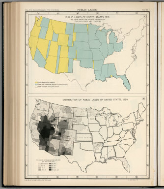
1932 Plate 59. Public Lands of United States, … [Historical Atlas, National Atlas] Plate 59. Public Lands. Public Lands of … |

1932 Plate 60. Settlement and Population, 166 … [Historical Atlas, National Atlas] Plate 60. Settlement and Population, 166 … |
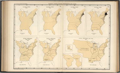
1932 Plate 61. Colonial Towns, States, Territ … [Historical Atlas, National Atlas] Plate 61. Colonial Towns, States, Territ … |

1932 Plate 62. States, Territories and Cities … [Historical Atlas, National Atlas] Plate 62. States, Territories and Cities … |

1932 Plate 63. States, Territories and Cities … [Historical Atlas, National Atlas] Plate 63. States, Territories and Cities … |

1932 Plate 64. States, Territories and Cities … [Historical Atlas, National Atlas] Plate 64. States, Territories and Cities … |

1932 Plate 65. States, Territories and Cities … [Historical Atlas, National Atlas] Plate 65. States, Territories and Cities … |

1932 Plate 66. States, Territories and Cities … [Historical Atlas, National Atlas] Plate 66. States, Territories and Cities … |

1932 Plate 67. States and Cities: Population, … [Historical Atlas, National Atlas] Plate 67. States and Cities: Population. … |

1932 Plate 68. Population. Slaves, 1850 - 186 … [Historical Atlas, National Atlas] Plate 68. Population. Slaves, 1850. Slav … |

1932 Plate 69. Population. Free Negroes, 1860 … [Historical Atlas, National Atlas] Plate 69. Population. Free Negroes, 1860 … |

1932 Plate 70. Population: Emigration to the … [Historical Atlas, National Atlas] Plate 70. Population: Emigration to the … |

1932 Plate 71. Population. Foreign-Born Popul … [Historical Atlas, National Atlas] Plate 71. Population. Foreign-Born Popul … |

1932 Plate 72. Population. Foreign-Born Popul … [Historical Atlas, National Atlas] Plate 72. Population. Foreign-Born Popul … |

1932 Plate 73. Population. Foreign-Born Popul … [Historical Atlas, National Atlas] Plate 73. Population. Foreign-Born Popul … |

1932 Plate 74. Population. Foreign-Born Popul … [Historical Atlas, National Atlas] Plate 74. Population. Foreign-Born Popul … |

1932 Plate 75. Population. Foreign-Born Popul … [Historical Atlas, National Atlas] Plate 75. Population. Foreign-Born Popul … |

1932 Plate 76. Population. Foreign-Born Popul … [Historical Atlas, National Atlas] Plate 76. Population. Foreign-Born Popul … |

1932 Plate 77. Population. Density of Populat … [Historical Atlas, National Atlas] Plate 77. Population. Density of Populat … |

1932 Plate 78. Population. Density of Populat … [Historical Atlas, National Atlas] Plate 78. Population. Density of Populat … |

1932 Plate 79. Density of Population, 1900 - … [Historical Atlas, National Atlas] Plate 79. Density of Population. Density … |

1932 Plate 80. Population: Colleges and Unive … [Historical Atlas, National Atlas] Plate 80. Population: Colleges and Unive … |

1932 Plate 81. Colleges and Universities, 186 … [Historical Atlas, National Atlas] Plate 81. Colleges and Universities. Col … |

1932 Plate 82. Churches, 1775-1776. [Historical Atlas, National Atlas] Plate 82. Churches. Congregationalist, 1 … |

1932 Plate 83. Churches, 1860. [Historical Atlas, National Atlas] Plate 83. Churches. Methodist, 1860. Bap … |

1932 Plate 84. Churches, 1860. [Historical Atlas, National Atlas] Plate 84. Churches. Congregational, 1860 … |

1932 Plate 85. Churches, 1860. [Historical Atlas, National Atlas] Plate 85. Churches. Catholic, 1860. Meth … |

1932 Plate 86. Churches, 1890. [Historical Atlas, National Atlas] Plate 86. Churches. Baptist, 1890. Presb … |

1932 Plate 87. Churches, 1890. [Historical Atlas, National Atlas] Plate 87. Churches. Catholic, 1890. Cong … |

1932 Plate 88. Churches, 1890. [Historical Atlas, National Atlas] Plate 88. Churches. Disciples of Christ, … |

1932 Plate 89. Negotiation for Peace, 1779 - … [Historical Atlas, National Atlas] Plate 89. Negotiation for Peace, 1779 - … |

1932 Plate 90. Negotiation for Peace, 1779 - … [Historical Atlas, National Atlas] Plate 90. Negotiation for Peace, 1779 - … |

1932 Plate 91. International Boundary Dispute … [Historical Atlas, National Atlas] Plate 91. International Boundary Dispute … |