|
REFINE
Browse All : National Atlas and U.S. Public Survey of United States
1-13 of 13
Author
[Paullin, Charles O., Wright, John K.]
Full Title
Plate 57. Public Lands. Public Lands of United States, 1790. Public Lands of United States, 1810.
Publisher
[Carnegie Institution of Washington, American Geographical Society of New York]
Author
[Paullin, Charles O., Wright, John K.]
Full Title
Plate 58. Public Lands. Public Lands of United States, 1830. Public Lands of United States, 1850. Public Lands of United States, 1870. Public Lands of United States, 1890.
Publisher
[Carnegie Institution of Washington, American Geographical Society of New York]
Author
[Paullin, Charles O., Wright, John K.]
Full Title
Plate 59. Public Lands. Public Lands of United States, 1910. Distribution of Public Lands of United States, 1929.
Publisher
[Carnegie Institution of Washington, American Geographical Society of New York]
Author
[Paullin, Charles O., Wright, John K.]
Full Title
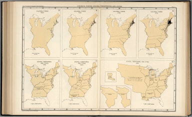
Plate 61. Colonial Towns, States, Territories, and Cities. Colonial Towns, 1650. Colonial Towns, 1700. Colonial Towns, 1750. Colonial Towns, 1775. States, Territories and Cities, 1790. States, Territories and Cities, 1800. States, Territories and Cities, 1810.
Publisher
[Carnegie Institution of Washington, American Geographical Society of New York]
Author
[Paullin, Charles O., Wright, John K.]
Full Title
Plate 62. States, Territories and Cities. States, Territories and Cities, 1820. States, Territories and Cities, 1830.
Publisher
[Carnegie Institution of Washington, American Geographical Society of New York]
Author
[Paullin, Charles O., Wright, John K.]
Full Title
Plate 63. States, Territories and Cities. States, Territories and Cities, 1840. States, Territories and Cities, 1850.
Publisher
[Carnegie Institution of Washington, American Geographical Society of New York]
Author
[Paullin, Charles O., Wright, John K.]
Full Title
Plate 64. States, Territories and Cities. States, Territories and Cities, 1860. States, Territories and Cities, 1870. States and Territories (Additional Maps 1845-1868). States, Territories and Cities, 1880.
Publisher
[Carnegie Institution of Washington, American Geographical Society of New York]
Author
[Paullin, Charles O., Wright, John K.]
Full Title
Plate 65. States, Territories and Cities. States, Territories and Cities, 1890. States, Territories and Cities, 1900.
Publisher
[Carnegie Institution of Washington, American Geographical Society of New York]
Author
[Paullin, Charles O., Wright, John K.]
Full Title
Plate 66. States, Territories and Cities. States, Territories and Cities, 1910. States, Territories and Cities, 1920.
Publisher
[Carnegie Institution of Washington, American Geographical Society of New York]
Author
[Paullin, Charles O., Wright, John K.]
Full Title
Plate 67. States and Cities: Population. States and Cities, 1930. Slaves, 1790. Slaves, 1800. Slaves, 1810. Slaves, 1820. Slaves, 1830. Slaves, 1840.
Publisher
[Carnegie Institution of Washington, American Geographical Society of New York]
Author
U.S. General Land Office
Full Title
(Covers to) Maps accompanying Report of the commissioner of the General Land Office.
Publisher
U.S.
Author
U.S. General Land Office
Full Title
(Contents to) Maps accompanying Report of the commissioner of the General Land Office.
Publisher
U.S.
Author
U.S. General Land Office
Full Title
Map of the United States and Territories. Shewing the extent of the Public Surveys and other details Constructed From the Plats and official sources of the General Land Office Under the direction of the Hon. Jos. S. Wilson, Commissioner, by Theodore Franks, Draughtsman. 1866. Department of the Interior, General Land Office, October 2nd 1866. Jo. S. Wilson, Commissioner. Engraved by D. McClelland, Washn. D.C.
Publisher
U.S.
1-13 of 13
|