Who What Where WhenREMOVE |
Author
Venezuela-British Guiana Boundary Commission
Full Title
Drainage Basin. 3. S Doc 91 55 2. The Orinoco - Essequibo Region, South America, Compiled under the Direction of the Commission Appointed "To Investigate and Report upon the True Divisional Line between the Republic of Venezuela and British Guiana." Washington D.C. 1897. Lith. by A. Hoen & Co., Baltimore, MD.
Publisher
United States of America
Author
Venezuela-British Guiana Boundary Commission
Full Title
Geology. 4. S Doc 91 55 2. Geological Map. The Orinoco - Essequibo Region, South America, Compiled under the Direction of the Commission Appointed "To Investigate and Report upon the True Divisional Line between the Republic of Venezuela and British Guiana." Washington D.C. 1897. Lith. by A. Hoen & Co., Baltimore, MD.
Publisher
United States of America
Author
Venezuela-British Guiana Boundary Commission
Full Title
1597. 5. S Doc 91 55 2. Historical Map Showing European Occupation in the year 1597. The Orinoco - Essequibo Region, South America, Compiled under the Direction of the Commission Appointed "To Investigate and Report upon the True Divisional Line between the Republic of Venezuela and British Guiana." Washington D.C. 1897. Lith. by A. Hoen & Co., Baltimore, MD.
Publisher
United States of America
Author
Venezuela-British Guiana Boundary Commission
Full Title
1626. 6. S Doc 91 55 2. Historical Map Showing European Occupation in the Year 1626. The Orinoco - Essequibo Region, South America, Compiled under the Direction of the Commission Appointed "To Investigate and Report upon the True Divisional Line between the Republic of Venezuela and British Guiana." Washington D.C. 1897. Lith. by A. Hoen & Co., Baltimore, MD.
Publisher
United States of America
Author
Venezuela-British Guiana Boundary Commission
Full Title
1648. 7. S Doc 91 55 2. Historical Map Showing European Occupation in the Year 1648. The Orinoco - Essequibo Region, South America, Compiled under the Direction of the Commission Appointed "To Investigate and Report upon the True Divisional Line between the Republic of Venezuela and British Guiana." Washington D.C. 1897. Lith. by A. Hoen & Co., Baltimore, MD.
Publisher
United States of America
Author
Venezuela-British Guiana Boundary Commission
Full Title
1674. 8. S Doc 91 55 2. Historical Map Showing European Occupation in the Year 1674. The Orinoco - Essequibo Region, South America, Compiled under the Direction of the Commission Appointed "To Investigate and Report upon the True Divisional Line between the Republic of Venezuela and British Guiana." Washington D.C. 1897. Lith. by A. Hoen & Co., Baltimore, MD.
Publisher
United States of America
Author
Venezuela-British Guiana Boundary Commission
Full Title
1703. 9. S Doc 91 55 2. Historical Map Showing European Occupation in the Year 1703. The Orinoco - Essequibo Region, South America, Compiled under the Direction of the Commission Appointed "To Investigate and Report upon the True Divisional Line between the Republic of Venezuela and British Guiana." Washington D.C. 1897. Lith. by A. Hoen & Co., Baltimore, MD.
Publisher
United States of America
Author
Venezuela-British Guiana Boundary Commission
Full Title
1724. 10. S Doc 91 55 2. Historical Map Showing European Occupation in the Year 1724. The Orinoco - Essequibo Region, South America, Compiled under the Direction of the Commission Appointed "To Investigate and Report upon the True Divisional Line between the Republic of Venezuela and British Guiana." Washington D.C. 1897. Lith. by A. Hoen & Co., Baltimore, MD.
Publisher
United States of America
Author
Venezuela-British Guiana Boundary Commission
Full Title
1756. 11. S Doc 91 55 2. Historical Map Showing European Occupation in the Year 1756. The Orinoco - Essequibo Region, South America, Compiled under the Direction of the Commission Appointed "To Investigate and Report upon the True Divisional Line between the Republic of Venezuela and British Guiana." Washington D.C. 1897. Lith. by A. Hoen & Co., Baltimore, MD.
Publisher
United States of America
Author
Venezuela-British Guiana Boundary Commission
Full Title
1772. 12. S Doc 91 55 2. Historical Map Showing European Occupation in the Year 1772. The Orinoco - Essequibo Region, South America, Compiled under the Direction of the Commission Appointed "To Investigate and Report upon the True Divisional Line between the Republic of Venezuela and British Guiana." Washington D.C. 1897. Lith. by A. Hoen & Co., Baltimore, MD.
Publisher
United States of America
Author
Venezuela-British Guiana Boundary Commission
Full Title
1796. 13. S Doc 91 55 2. Historical Map Showing European Occupation in the Year 1796. The Orinoco - Essequibo Region, South America, Compiled under the Direction of the Commission Appointed "To Investigate and Report upon the True Divisional Line between the Republic of Venezuela and British Guiana." Washington D.C. 1897. Lith. by A. Hoen & Co., Baltimore, MD.
Publisher
United States of America
Author
Venezuela-British Guiana Boundary Commission
Full Title
1803 (1814). 14. S Doc 91 55 2. Historical Map Showing European Occupation in the Year 1803. (The Date when Essequibo - Restored to the Dutch in 1802 - Passed Finally into British Hands, though not Ceded until 1814.). The Orinoco - Essequibo Region, South America, Compiled under the Direction of the Commission Appointed "To Investigate and Report upon the True Divisional Line between the Republic of Venezuela and British Guiana." Washington D.C. 1897. Lith. by A. Hoen & Co., Baltimore, MD.
Publisher
United States of America
Author
Venezuela-British Guiana Boundary Commission
Full Title
1597 - 1803 (1814). 15. S Doc 91 55 2. Historical Map Showing European Occupation in the Year 1597 - 1803. (A General View with Dates of Occupation and Abandonment). The Orinoco - Essequibo Region, South America, Compiled under the Direction of the Commission Appointed "To Investigate and Report upon the True Divisional Line between the Republic of Venezuela and British Guiana." Washington D.C. 1897. Lith. by A. Hoen & Co., Baltimore, MD.
Publisher
United States of America
Author
Venezuela-British Guiana Boundary Commission
Full Title
(Covers to) Maps Of The Orinoco-Essequibo Region, South America. Compiled For The Commission Appointed By The President Of The United States "To Investigate And Report Upon The True Divisional Line Between The Republic Of Venezuela And British Guiana". Commissioners, David J. Brewer, President, Richard H. Alvey, Frederic R. Coudert, Andrew D. White, Daniel C. Gilman, Severo Mallet-Prevost, Secretary. Washington. February, 1897.
Publisher
United States of America
Author
Venezuela-British Guiana Boundary Commission
Full Title
(Half Title Page) Venezuelan Boundary Commission. Report and Accompanying Papers ... Volume 4. Atlas.
Publisher
United States of America
Author
Venezuela-British Guiana Boundary Commission
Full Title
(Title Page to) Maps Of The Orinoco-Essequibo Region, South America. Compiled For The Commission Appointed By The President Of The United States "To Investigate And Report Upon The True Divisional Line Between The Republic Of Venezuela And British Guiana". Commissioners, David J. Brewer, President, Richard H. Alvey, Frederic R. Coudert, Andrew D. White, Daniel C. Gilman, Severo Mallet-Prevost, Secretary. Washington. February, 1897.
Publisher
United States of America
Author
Venezuela-British Guiana Boundary Commission
Full Title
(Text Page) Introduction.
Publisher
United States of America
Author
Venezuela-British Guiana Boundary Commission
Full Title
(Table of Contents) Contents.
Publisher
United States of America
Author
Venezuela-British Guiana Boundary Commission
Full Title
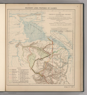
Boundary Lines Proposed or Claimed. 1. S Doc 91 55 2. The Orinoco - Essequibo Region, South America Compiled under the Direction of the Commission Appointed "To Investigate and Report upon the True Divisional Line between the Republic of Venezuela and British Guiana." 1897. Lith. by A. Hoen & Co., Baltimore, MD.
Publisher
United States of America
Author
Venezuela-British Guiana Boundary Commission
Full Title
Forests and Savannas. 2. S Doc 91 55 2. The Orinoco - Essequibo Region, South America, Compiled under the Direction of the Commission Appointed "To Investigate and Report upon the True Divisional Line between the Republic of Venezuela and British Guiana." Washington D.C. 1897. Lith. by A. Hoen & Co., Baltimore, MD.
Publisher
United States of America
Author
Reichsamt fur Landesaufnahme
Full Title
Sheet 557. Neustadt a. d. Haardt. Karte des Deutschen Reiches.
Publisher
Reichsamt fur Landesaufnahme
Author
Reichsamt fur Landesaufnahme
Full Title
(Composite of) Sheet 557. Neustadt a. d. Haardt. Karte des Deutschen Reiches.
Publisher
Reichsamt fur Landesaufnahme
Author
Reichsamt fur Landesaufnahme
Full Title
Sheet 560. Mergentheim. Karte des Deutschen Reiches.
Publisher
Reichsamt fur Landesaufnahme
Author
Reichsamt fur Landesaufnahme
Full Title
(Composite of) Sheet 560. Mergentheim. Karte des Deutschen Reiches.
Publisher
Reichsamt fur Landesaufnahme
Author
Reichsamt fur Landesaufnahme
Full Title
Sheet 614. Passau. Karte des Deutschen Reiches.
Publisher
Reichsamt fur Landesaufnahme
Author
Reichsamt fur Landesaufnahme
Full Title
(Composite of) Sheet 614. Passau. Karte des Deutschen Reiches.
Publisher
Reichsamt fur Landesaufnahme
Author
Reichsamt fur Landesaufnahme
Full Title
Sheet 640. Burghausen. Karte des Deutschen Reiches.
Publisher
Reichsamt fur Landesaufnahme
Author
Reichsamt fur Landesaufnahme
Full Title
(Composite of) Sheet 640. Burghausen. Karte des Deutschen Reiches.
Publisher
Reichsamt fur Landesaufnahme
Author
Reichsamt fur Landesaufnahme
Full Title
Sheet 648. Memmingen. Karte des Deutschen Reiches.
Publisher
Reichsamt fur Landesaufnahme
Author
Reichsamt fur Landesaufnahme
Full Title
(Composite of) Sheet 648. Memmingen. Karte des Deutschen Reiches.
Publisher
Reichsamt fur Landesaufnahme
Author
Reichsamt fur Landesaufnahme
Full Title
Sheet 652. Rosenheim. Karte des Deutschen Reiches.
Publisher
Reichsamt fur Landesaufnahme
Author
Reichsamt fur Landesaufnahme
Full Title
(Composite of) Sheet 652. Rosenheim. Karte des Deutschen Reiches.
Publisher
Reichsamt fur Landesaufnahme
Author
Reichsamt fur Landesaufnahme
Full Title
Sheet 660. Lindau. Karte des Deutschen Reiches.
Publisher
Reichsamt fur Landesaufnahme
Author
Reichsamt fur Landesaufnahme
Full Title
(Composite of) Sheet 660. Lindau. Karte des Deutschen Reiches.
Publisher
Reichsamt fur Landesaufnahme
Author
Reichsamt fur Landesaufnahme
Full Title
Sheet 666. Reit im Winkel. Karte des Deutschen Reiches.
Publisher
Reichsamt fur Landesaufnahme
Author
Reichsamt fur Landesaufnahme
Full Title
(Composite of) Sheet 666. Reit im Winkel. Karte des Deutschen Reiches.
Publisher
Reichsamt fur Landesaufnahme
Author
Reichsamt fur Landesaufnahme
Full Title
Sheet 255. Laar. Karte des Deutschen Reiches.
Publisher
Reichsamt fur Landesaufnahme
Author
Reichsamt fur Landesaufnahme
Full Title
(Composite of) Sheet 255. Laar. Karte des Deutschen Reiches.
Publisher
Reichsamt fur Landesaufnahme
Author
Reichsamt fur Landesaufnahme
Full Title
Sheet 309. Lemgo. Karte des Deutschen Reiches.
Publisher
Reichsamt fur Landesaufnahme
Author
Reichsamt fur Landesaufnahme
Full Title
(Composite of) Sheet 309. Lemgo. Karte des Deutschen Reiches.
Publisher
Reichsamt fur Landesaufnahme
Author
Reichsamt fur Landesaufnahme
Full Title
Sheet 310. Hameln. Karte des Deutschen Reiches.
Publisher
Reichsamt fur Landesaufnahme
Author
Reichsamt fur Landesaufnahme
Full Title
(Composite of) Sheet 310. Hameln. Karte des Deutschen Reiches.
Publisher
Reichsamt fur Landesaufnahme
Author
Reichsamt fur Landesaufnahme
Full Title
Sheet 311. Hildesheim. Karte des Deutschen Reiches.
Publisher
Reichsamt fur Landesaufnahme
Author
Reichsamt fur Landesaufnahme
Full Title
(Composite of) Sheet 311. Hildesheim. Karte des Deutschen Reiches.
Publisher
Reichsamt fur Landesaufnahme
Author
[Ordnance Survey of Scotland, Farquharson, J.]
Full Title
Sheet 4 - Wigtown. Ordnance Survey of Scotland. Engraved at the Ordnance Survey, Southampton. Surveyed in 1845-49 and published by Lt. Colonel James, F.R.S., M.R.I.A., R.E. Director General, 1857. Revised in 1895 and published by Colonel J. Farquharson, C.B.R.E., Director General, 1897. Edward Stanford, London Agency for Ordnance Maps ...(to accompany) Ordnance Survey of Scotland: Scale 1 inch to a mile. Volume I.
Publisher
[Ordnance survey Office, Edward Stanford]
Author
[Ordnance Survey of Scotland, Farquharson, J.]
Full Title
Sheet 5 - Kirkcudbright. Ordnance Survey of Scotland. Engraved at the Ordnance Survey, Southampton. Surveyed in 1847-50 and published by Lt. Colonel James, F.R.S., M.R.I.A., R.E. Director General, 1857. Revised in 1895 and published by Colonel J. Farquharson, C.B.R.E., Director General, 1897. Edward Stanford, London Agency for Ordnance Maps ...(to accompany) Ordnance Survey of Scotland: Scale 1 inch to a mile. Volume I.
Publisher
[Ordnance survey Office, Edward Stanford]
Author
[Ordnance Survey of Scotland, Farquharson, J.]
Full Title
Sheet 8 - Carrick. Ordnance Survey of Scotland. Engraved at the Ordnance Survey, Southampton. Surveyed in 1848-56 and published by Colonel Sir Henry James, F.R.S., M.R.I.A., R.E. Director General, 1863. Revised in 1895 and published by Colonel J. Farquharson, C.B.R.E., Director General, 1897. Edward Stanford, London Agency for Ordnance Maps ...(to accompany) Ordnance Survey of Scotland: Scale 1 inch to a mile. Volume I.
Publisher
[Ordnance survey Office, Edward Stanford]
Author
[Ordnance Survey of Scotland, Farquharson, J.]
Full Title
Sheet 9 - Maxwelltown. Ordnance Survey of Scotland. Engraved at the Ordnance Survey, Southampton. Surveyed in 1848-57 and published by Colonel Sir Henry James, F.R.S., M.R.I.A., R.E. Director General, 1863. Revised in 1895 and published by Colonel J. Farquharson, C.B.R.E., Director General, 1897. Edward Stanford, London Agency for Ordnance Maps ...(to accompany) Ordnance Survey of Scotland: Scale 1 inch to a mile. Volume I.
Publisher
[Ordnance survey Office, Edward Stanford]
Author
[Ordnance Survey of Scotland, Farquharson, J.]
Full Title
Sheet 10 - Dumfries. Ordnance Survey of Scotland. Engraved at the Ordnance Survey, Southampton. Surveyed in 1849-58 and published by Colonel Sir Henry James, F.R.S., M.R.I.A., R.E. Director General, 1864. Revised in 1895 and published by Colonel J. Farquharson, C.B.R.E., Director General, 1897. Edward Stanford, London Agency for Ordnance Maps ...(to accompany) Ordnance Survey of Scotland: Scale 1 inch to a mile. Volume I.
Publisher
[Edward Stanford, Ordnance survey Office]
Author
[Ordnance Survey of Scotland, Farquharson, J.]
Full Title
Sheet 14 - Ayr. Ordnance Survey of Scotland. Engraved at the Ordnance Survey, Southampton. Surveyed in 1849-57 and published by Colonel Sir Henry James, F.R.S., M.R.I.A., R.E. Director General, 1863. Revised in 1895 and published by Colonel J. Farquharson, C.B.R.E., Director General, 1897. Edward Stanford, London Agency for Ordnance Maps ...(to accompany) Ordnance Survey of Scotland: Scale 1 inch to a mile. Volume I.
Publisher
[Ordnance survey Office, Edward Stanford]
|