Browse All

1874 Kansas. National Atlas Asher & Adams' Kansas. Entered according … |

1874 Nebraska. National Atlas Asher & Adams' Nebraska. Entered accordi … |

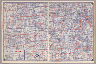
1950 Shell Highway Map of Kansas. National Atlas Shell Map of Kansas (cover title). Shell … |

1950 Various Regions and Cities in Kansas. National Atlas Wichita. Topeka. Hutchinson. Salina. Kan … |

1874 County & Township Map of the States of K … National Atlas County & Township Map of the States of K … |

1872 Utah, Arizona, New Mexico, Kansas, Color … [National Atlas, State Atlas] Atlas of the United States, Map of Utah, … |

1875 Kansas. [Commercial Reference Book, National Atl Asher & Adams' Kansas. Entered according … |

1927 Kansas. National Atlas Rand McNally junior auto road map Kansas … |

1927 Chicago, Omaha, Kansas City. National Atlas Chicago and vicinity. Omaha and vicinity … |

1927 Kansas National Atlas Kansas. (Copyrighted by) National Map Co … |

1875 Kansas. National Atlas Cram's Rail Road & Township Map of Kansa … |

1940 Road map of Kansas National Atlas Rand McNally Road map, Kansas. Copyright … |

1885 Kansas National Atlas Kansas. (to accompany) Bradstreet's Pock … |

1881 Kansas. National Atlas Gray's New Map of Kansas by Frank A. Gra … |

1878 Kansas. National Atlas Cram's Rail Road & Township Map of Kansa … |
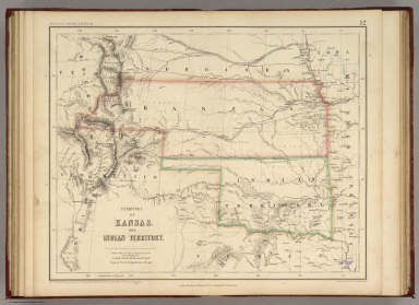
1857 Territory of Kansas And Indian Territory … National Atlas Territory of Kansas And Indian Territory … |
1939 Rand McNally Road map: Kansas National Atlas Rand McNally Road map: Kansas. Copyright … |

1935 Kansas. National Atlas Kansas. |

1889 Territory of Wyoming, Alabama, Louisiana … National Atlas Territory of Wyoming, Alabama, Louisiana … |

1852 Nebraska, Kansas, Iowa, Missouri. National Atlas (Nebraska, Kansas, Iowa, Missouri). |

1924 Text Page: Industrial Statistics of the … National Atlas (Text Page) Industrial Statistics of the … |

1924 AutoTrails Map, Iowa, Eastern Nebraska, … National Atlas Commercial Atlas of America. Rand McNall … |

1924 Kansas. National Atlas Commercial Atlas of America. Rand McNall … |

1924 Text Page: Kansas - Geographical Feature … National Atlas (Text Page) Kansas - Counties, Creeks, R … |

1924 AutoTrails Map, Southern Nebraska, Easte … National Atlas Commercial Atlas of America. Rand McNall … |

1924 Text Page: Kansas - Geographical Feature … National Atlas (Text Page) Kansas - Counties, Creeks, R … |

1924 Kansas. National Atlas Commercial Atlas of America. Rand McNall … |

1857 Nebraska And Kansas. National Atlas Nebraska and Kansas. No. 50. Published b … |

1903 Text Page: Oklahoma. Kansas. National Atlas (Text Page) Rand, McNally Co.'s Oklahoma … |

1903 Text Page: Kansas. National Atlas (Text Page) Rand, McNally Co.'s Kansas. |

1903 Text Page: Kansas. National Atlas (Text Page) Rand, McNally Co.'s Kansas. |

1903 Kansas. National Atlas Rand, McNally & Co.'s Kansas. |

1889 Text Page: Louisiana. Kansas. National Atlas (Text Page) Louisiana. Kansas. |

1889 Text Page: Kansas. National Atlas (Text Page) Kansas. |

1889 Text Page: Kansas. Nebraska. National Atlas (Text Page) Kansas. Nebraska. |

1889 Kansas. National Atlas Rand, McNally & Co.'s Kansas. |

1879 Kansas. National Atlas Rand, McNally & Co.'s Kansas. |

1866 Kansas, Nebraska. National Atlas (12) Map Showing the progress of the Pub … |