Browse All

1796 Province of Maine. National Atlas The Province of Maine, From the best Aut … |

1776 The Provinces of Massachusetts Bay and N … National Atlas A Map of the most Inhabited part of New … |

1823 Maine. [Manuscript Map, National Atlas] Maine. |

1823 (Description of) Maine. [Manuscript Map, National Atlas] (Description of) Maine. |

1867 Schonberg's Map of Maine and New Brunswi … National Atlas Schonberg's Map of Maine and New Brunswi … |

1956 Shell Highway Map of Maine. National Atlas Shell Map of Maine and Maritime Province … |

1956 Various Regions and Cities in and around … National Atlas Quebec. Portland. Regional map of Maine, … |

1874 Maine, N.B. National Atlas Asher & Adams' Maine and New Brunswick w … |

1874 County Map of Maine. National Atlas County Map of the State of Maine. (inset … |

1845 Maine. National Atlas Maine. (By Sidney E. Morse and Samuel Br … |

1837 Maine. [National Atlas, School Atlas] (Maine). |

1875 Maine, New Brunswick, with portions of Q … [Commercial Reference Book, National Atl Asher & Adams' Maine, New Brunswick, wit … |

1825 Maine. National Atlas Carte geographique, statistique et histo … |

1927 Maine. National Atlas Rand McNally junior auto road map Maine. … |

1857 Maine. National Atlas Maine. No. 9. Published by J.H. Colton & … |

1838 Maine. National Atlas Maine. Entered ... 1838, by T.G. Bradfor … |

1826 Map of Maine New Hampshire And Vermont. National Atlas Map of Maine New Hampshire And Vermont, … |

1927 Maine National Atlas Maine. (Copyrighted by) National Map Com … |

1832 Maine, N.H., Vt. National Atlas Map of Maine, New Hampshire and Vermont. … |

1834 Canal de la Chesapeake a l'Ohio. National Atlas Canal de la Chesapeake a l'Ohio. Plan ge … |

1823 Maine, N.H., Vermont. National Atlas Maine, New Hampshire and Vermont. N. & S … |

1796 Province of Maine. National Atlas Province of Maine. Engraved by A. Doolit … |

1940 Road map of Maine, New Hampshire, Vermon … National Atlas Rand McNally Road map, Maine, New Hampsh … |

1885 Maine National Atlas Maine. (to accompany) Bradstreet's Pocke … |

1828 Maine National Atlas Part Of Maine &c. with The Boundary Clai … |

1842 Maine National Atlas Maine. (to accompany) Supplement To The … |

1827 Maine, New Hampshire, and Vermont. National Atlas Map of Maine, New Hampshire, and Vermont … |

1855 Maine. National Atlas Maine. Entered ... 1855 by J.H. Colton & … |

1878 New England. National Atlas Cram's Rail Road & County Map of New Eng … |

1939 Rand McNally Road map: Maine, New Hampsh … National Atlas Rand McNally Road map: Maine, New Hampsh … |

1935 Maine. National Atlas Maine. |

1845 Maine National Atlas Maine. (By Sidney E. Morse and Samuel Br … |

1795 Province of Maine. National Atlas The Province of Maine, From the best Aut … |

1889 South Carolina, Wisconsin, Maine, Michig … National Atlas South Carolina, Wisconsin, Maine, Michig … |

1831 Map of Maine, New Hampshire,and Vermont. National Atlas Map of Maine, New Hampshire And Vermont, … |

1852 Quebec, New Brunswick, Maine, Vermont, N … National Atlas (Quebec, New Brunswick, Maine, Vermont, … |

1827 Maine, New Hampshire, Vermont. National Atlas Map of Maine, New Hampshire, and Vermont … |

1924 Text Page: Industrial Statistics of the … National Atlas (Text Page) Industrial Statistics of the … |

1924 Text Page: Industrial Statistics of the … National Atlas (Text Page) Industrial Statistics of the … |

1924 Maine. National Atlas Commercial Atlas of America. Rand McNall … |

1924 Text Page: Maine - Geographical Features … National Atlas (Text Page) Maine - Counties, Islands, L … |

1924 New England, Eastern New York. National Atlas Commercial Atlas of America. Rand McNall … |

1924 Maine. National Atlas Commercial Atlas of America. Rand McNall … |

1856 Maine. National Atlas Maine. Published by A. & C. Black. Edinb … |

1889 Text Page: Maine. National Atlas (Text Page) Maine. |

1889 Text Page: Maine. National Atlas (Text Page) Maine. |
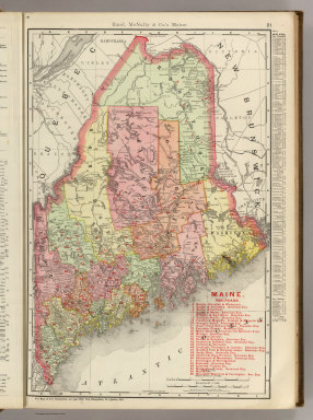
1903 Maine. National Atlas Rand, McNally & Co.'s Maine. |

1889 Maine. National Atlas Rand, McNally & Co.'s Maine. |

1903 Text Page: Maine. National Atlas (Text Page) Rand, McNally Co.'s Maine. |

1903 Text Page: Maine. National Atlas (Text Page) Rand, McNally Co.'s Maine. |