Who What Where WhenREMOVE |
Author
Mitchell, Samuel Augustus
Full Title
Map Of South America According To The Latest and Best Authorities. Published by S. Augustus Mitchell Philadelphia. 1831. J.H. Young Sc.
Publisher
S.A. Mitchell
Author
[Reid, John, Winterbotham, W.]
Full Title
A General Map Of South America. From the Best Surveys, 1796. B. Tanner, sculpt. New-York,Published by John Reid.
Publisher
John Reid
Author
Jefferys, Thomas
Full Title
Chart containing the greater part of the South Sea to the South of the Line, with the Islands dispersed thro' the same. South America with the adjacent Islands in the Southern Ocean and South Sea. Published ... 10 June 1775, by R. Sayer & J. Bennett ... Fleet Street. VI.
Publisher
Sayer and Bennett
Author
Jefferys, Thomas
Full Title
A Map Of South America Containing Tierra-Firma, Guayana, New Granada, Amazonia, Brasil, Peru, Paraguay, Chaco, Tucuman, Chili and Patagonia. from Mr. D'Anville with Several Improvements and Additions, and The Newest Discoveries. London. Printed for Robert Sayer, No. 53, Fleet Street as the Act Directs 20 September 1775. (with) A Chart Of Falkland's Islands named by the French Malouine Islands, and Discovered by Hawkins in the Year 1593. (Northern Section)
Publisher
Sayer and Bennett
Author
Jefferys, Thomas
Full Title
A Map Of South America Containing Tierra-Firma, Guayana, New Granada, Amazonia, Brasil, Peru, Paraguay, Chaco, Tucuman, Chili and Patagonia. from Mr. D'Anville with Several Improvements and Additions, and The Newest Discoveries. London. Printed for Robert Sayer, No. 53, Fleet Street as the Act Directs 20 September 1775. (Southern Section)
Publisher
Sayer and Bennett
Author
Jefferys, Thomas
Full Title
(Composite of) A Map Of South America Containing Tierra-Firma, Guayana, New Granada, Amazonia, Brasil, Peru, Paraguay, Chaco, Tucuman, Chili and Patagonia. from Mr. D'Anville with Several Improvements and Additions, and The Newest Discoveries. London. Printed for Robert Sayer, No. 53, Fleet Street as the Act Directs 20 September 1775.
Publisher
Sayer and Bennett
Full Title
Carte geographique, statistique et historique de l'Amerique. Amerique Sept. Grave par B. Beaupre, Rue de Vanguard No. 81. Amerique Merid. ... Fonderie et Imprimerie de J. Carez. (1825)
Publisher
J. Carez
Full Title
Pantographie de l'histoire d'Amerique, ou description de la situation relative des etats et colonies de l'Amerique, depuis sa decouverte jusqu'a l'annee 1825. Fonderie et Imprimerie de J. Carez.
Publisher
J. Carez
Full Title
Carte geographique, statistique et historique de l'Amerique Meridionale. Carte de l'Amerique Meridionale. Grave par B. de Beaupre, gravr. au Dept. Gal. de la Guerre, Rue de Vaugirard, no. 81. Fonderie et Imprimerie de J. Carez. (1825)
Publisher
J. Carez
Full Title
Carte geographique, statistique et historique de la Republique Colombienne. Colombie. Grave par Beaupre, Rue de Vaugirard, No. 81, a Paris. Fonderie et Imprimerie de J. Carez. (1825)
Publisher
J. Carez
Author
Levasseur, Victor.
Full Title
Amerique Meridionale. Atlas Universel Illustre. Geographie et Statistique de V. Levasseur, Ingenieur Geographe. Grave par Laguillermie, Rue St. Jacques, No. 82. Illustre par Raimond Bonheur, Peintre. Impie. de Lemercier. Paris. A Paris, chez A. Combette, Editeur, Rue St. Jacques, No. 41. (1856)
Publisher
A. Combette
Author
Colton, G.W.
Full Title
(Covers to) Colton's Advertising Atlas Of America. Colton's Atlas Of America. Illustrating The Physical And Political Geography Of North And South America And The West India Islands, By George W. Colton. Accompanied By Descriptions Geographical, Statistical, And Historical, By Richard Swainson Fisher, M.D. New York: J.H. Colton And Company, No. 172 William, Corner Beekman Street. 1857. Entered ... One Thousand Eight Hundred and Fifty-five, by J.H. Colton And Company ... New York.
Publisher
J.H. Colton
Author
Colton, G.W.
Full Title
(Half Title Page to) Colton's Advertising Atlas Of America. Colton's Atlas Of America. Illustrating The Physical And Political Geography Of North And South America And The West India Islands, By George W. Colton. Accompanied By Descriptions Geographical, Statistical, And Historical, By Richard Swainson Fisher, M.D. New York: J.H. Colton And Company, No. 172 William, Corner Beekman Street. 1857. Entered ... One Thousand Eight Hundred and Fifty-five, by J.H. Colton And Company ... New York.
Publisher
J.H. Colton
Author
Colton, G.W.
Full Title
(Verso Half Title Page to) Colton's Advertising Atlas Of America. Colton's Atlas Of America. Illustrating The Physical And Political Geography Of North And South America And The West India Islands, By George W. Colton. Accompanied By Descriptions Geographical, Statistical, And Historical, By Richard Swainson Fisher, M.D. New York: J.H. Colton And Company, No. 172 William, Corner Beekman Street. 1857. Entered ... One Thousand Eight Hundred and Fifty-five, by J.H. Colton And Company ... New York.
Publisher
J.H. Colton
Author
Colton, G.W.
Full Title
(Title Page to) Colton's Atlas Of America. Illustrating The Physical And Political Geography Of North And South America And The West India Islands, By George W. Colton. Accompanied By Descriptions Geographical, Statistical, And Historical, By Richard Swainson Fisher, M.D. New York: J.H. Colton And Company, No. 172 William, Corner Beekman Street. 1857. Entered ... One Thousand Eight Hundred and Fifty-five, by J.H. Colton And Company ... New York.
Publisher
J.H. Colton
Author
Colton, G.W.
Full Title
(Verso Title Page to) Colton's Atlas Of America. Illustrating The Physical And Political Geography Of North And South America And The West India Islands, By George W. Colton. Accompanied By Descriptions Geographical, Statistical, And Historical, By Richard Swainson Fisher, M.D. New York: J.H. Colton And Company, No. 172 William, Corner Beekman Street. 1857. Entered ... One Thousand Eight Hundred and Fifty-five, by J.H. Colton And Company ... New York.
Publisher
J.H. Colton
Author
Colton, G.W.
Full Title
(Table of Contents to) Colton's Atlas Of America. Illustrating The Physical And Political Geography Of North And South America And The West India Islands, By George W. Colton. Accompanied By Descriptions Geographical, Statistical, And Historical, By Richard Swainson Fisher, M.D. New York: J.H. Colton And Company, No. 172 William, Corner Beekman Street. 1857. Entered ... One Thousand Eight Hundred and Fifty-five, by J.H. Colton And Company ... New York.
Publisher
J.H. Colton
Author
Finley, Anthony
Full Title
Map of South America According To The Latest and Best Authorities. 1826. D.H. Vance del. J.H. Young sc. Published by A. Finley Philada.
Publisher
Anthony Finley
Author
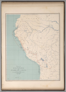
[Codazzi, Agustín, 1793-1859, Paz, Manuel María, 1820-1902]
Full Title
Mapa que contiene una parte de las Republicas del Ecuador, Peru y Bolivia para servir a la historia de las campanas del ejercito Colombiano en el alto y bajo Peru, 1823 a 1826. Grabado por Erhard Hermanos, 8 Calle Nicole, Paris. (to accompany) Atlas geografico e historico de la Republica de Colombia (Antigua Nueva Granada).
Publisher
A. Lahure
Author
[Codazzi, Agustín, 1793-1859, Paz, Manuel María, 1820-1902]
Full Title
Division politica de Colombia en 1824. Grabado por Erhard Hermanos, 8 Calle Nicole, Paris. (to accompany) Atlas geografico e historico de la Republica de Colombia (Antigua Nueva Granada).
Publisher
A. Lahure
Author
[Codazzi, Agustín, 1793-1859, Paz, Manuel María, 1820-1902]
Full Title
Carta de la Nueva Granada: dividida en provincias; 1832 a 1856; Uti-possidetis de 1810. Grabado por Erhard Hermanos, 8 Calle Nicole, Paris. (to accompany) Atlas geografico e historico de la Republica de Colombia (Antigua Nueva Granada).
Publisher
A. Lahure
Author
[Codazzi, Agustín, 1793-1859, Paz, Manuel María, 1820-1902]
Full Title
Carta de la Republica de Colombia (Antigua Nueva Granada) : dividida en departmentos ; 1886. Grabado por Erhard Hermanos, 8 Calle Nicole, Paris. (to accompany) Atlas geografico e historico de la Republica de Colombia (Antigua Nueva Granada).
Publisher
A. Lahure
Author
[Codazzi, Agustín, 1793-1859, Paz, Manuel María, 1820-1902]
Full Title
Carta que representa el sistema orografico y las vertientes y hoyas hidrograficas de Colombia. Grabado por Erhard Hermanos, 8 Calle Nicole, Paris. (to accompany) Atlas geografico e historico de la Republica de Colombia (Antigua Nueva Granada).
Publisher
A. Lahure
Author
[Codazzi, Agustín, 1793-1859, Paz, Manuel María, 1820-1902]
Full Title
Carta de Colombia que representa los territorios que han existido desde 1843 hasta 1886 hoy extinguidos. Grabado por Erhard Hermanos, 8 Calle Nicole, Paris. (to accompany) Atlas geografico e historico de la Republica de Colombia (Antigua Nueva Granada).
Publisher
A. Lahure
Author
[Codazzi, Agustín, 1793-1859, Paz, Manuel María, 1820-1902]
Full Title
Carta geologico de algunas montanas de Colombia. (with) Rios navegables que banan el territorio Colombiano. (with) Guadro del estado del globo en sus diferentes epocas. Grabado por Erhard Hermanos, 8 Calle Nicole, Paris. (to accompany) Atlas geografico e historico de la Republica de Colombia (Antigua Nueva Granada).
Publisher
A. Lahure
Author
[Codazzi, Agustín, 1793-1859, Paz, Manuel María, 1820-1902]
Full Title
Carta geologica de Colombia : Venezuela y Ecuador. Grabado por Erhard Hermanos, 8 Calle Nicole, Paris. (to accompany) Atlas geografico e historico de la Republica de Colombia (Antigua Nueva Granada).
Publisher
A. Lahure
Author
[Codazzi, Agustín, 1793-1859, Paz, Manuel María, 1820-1902]
Full Title
Carta postal y telegrafica de la Republica de Colombia (Antigua Nueva Granada). Grabado por Erhard Hermanos, 8 Calle Nicole, Paris. (to accompany) Atlas geografico e historico de la Republica de Colombia (Antigua Nueva Granada).
Publisher
A. Lahure
Author
[Codazzi, Agustín, 1793-1859, Paz, Manuel María, 1820-1902]
Full Title
Carta de Colombia la division eclesiastica. Grabado por Erhard Hermanos, 8 Calle Nicole, Paris. (to accompany) Atlas geografico e historico de la Republica de Colombia (Antigua Nueva Granada).
Publisher
A. Lahure
Author
[Rand McNally and Company, State Farm Insurance Companies Travel Bureau]
Full Title
Map of South and Central America. Showing proposed Inter-American Highway. Copyright by Rand McNally & Company, Chicago. Made in U.S.A. (to accompany) State Farm Road Atlas: United States, Canada, Mexico,Central and South America. Copyright 1940 by Rand McNally & Company, Chicago, Ill.
Publisher
State Farm Insurance Companies Travel Bureau
Author
Finley, Anthony
Full Title
Map of South America According to the Latest and Best Authorities, 1827.
Publisher
Anthony Finley
Author
Gray, O.W.
Full Title
South America.
Publisher
Stedman & Brown
Author
Codazzi, Agustin, 1793-1859
Full Title
Mapa de las costas de Tierra-Firme, desde el Orinoco hasta Yucatan: de las islas Antillas y la mayor parte de las Lucayas con las derrotas que siguio Dn. Cristobal Colon en sus descubrimientos por estos mares y las derrotas de otros navigantes que reconocieron las costas de Venezuela. Lith. de Thierry Frs. a Paris. (Caracas 1840)
Publisher
[Agostino Codazzi, Thierry Freres.]
Author
Codazzi, Agustin, 1793-1859
Full Title
Mapa politico de Venezuela antes de la Revolucion de 1810. Mapa politico de la Republica de Venezuela en 1840. Lith. de Thierry freres a Paris. (Caracas 1840)
Publisher
[Agostino Codazzi, Thierry Freres.]
Author
Carey, Mathew
Full Title
A Map Of South America According to the best Authorities. Engraved for Carey's American Edition of Guthrie's Geography improved.
Publisher
Mathew Carey
Author
Martin de Moussy, V. (Victor), 1810-1869
Full Title
Carte de l'Amerique du Sud divisee en ses differents etats. Par le Dr. V. Martin de Moussy 1867. Grave par Kautz, r. Bonaparte 82 Paris. Paris Imp. Lemercier, r. de Seine 57. (Paris Librairie de Firmin Didot Freres, Fils et Cie., 1873)
Publisher
Firmin Didot Freres.
Author
[Martin de Moussy, V. (Victor), 1810-1869, Petroschi, Giovanni]
Full Title
Paraquariae Provinciae Soc. Jesu cum adiacentib. novissima descriptio. Post iteratas peregrinationes, & plures observationes Patrum Missionariorum erusdem Soc. tum huius Provinciae, cum & Peruanae accuratissime delineata, & emendata ann. 1732. Admodum r. in Chto. Patri Suo P. Francisco Retz ... Ioannes Petroschi sculp. Romae sup. perm. ... Fac-simile d'une carte du Bassin de La Plata dressee par les Missionaires de la Compagnie de Jesus de la province du Paraguay. Publiee a Rome en 1732 et dediee au General de la dite Compagnie le R.P. Francois Retz. Gravee par Jean Petroschi. Paris - 1867. Grave par Kautz. Editee par le Dr. V. Martin de Moussy ... Paris - Imp. Lemercier, r. de Seine 57. (Paris Librairie de Firmin Didot Freres, Fils et Cie., 1873)
Publisher
Firmin Didot Freres.
Author
Martin de Moussy, V. (Victor), 1810-1869
Full Title
Carte de la Confederation Argentine divisee en ses differentes provinces et territoires et des pays voisins: Etat Oriental de l'Uruguay, Paraguay, partie du Bresil et de la Bolivie, Chili. Par le Dr. V. Martin de Moussy 1867. Grave par L. Kautz, r. Bonaparte 82 Paris. Paris - Imp. Lemercier, r. de Seine 57. (Paris Librairie de Firmin Didot Freres, Fils et Cie., 1873)
Publisher
Firmin Didot Freres.
Author
Martin de Moussy, V. (Victor), 1810-1869
Full Title
Carte historique de la Province des Missions et des etablissements des Jesuites sur le Parana et l'Uruguay de 1575 a 1768. Par le Dr. V. Martin de Moussy 1865. Grave par L. Kautz, r. Bonaparte 82 - Paris. Paris - Imp. Lemercier, r. de Seine 57. (Paris Librairie de Firmin Didot Freres, Fils et Cie., 1873)
Publisher
Firmin Didot Freres.
Author
Martin de Moussy, V. (Victor), 1810-1869
Full Title
Carte des voyages du Dr. V. Martin de Moussy. Chemins de fer executes dans le Bassin de la Plata. Traces des chemins de fer a l'etude et en projet. Esquisses des chemins de fer et des canaux praticables. Passage des Andes. Grave par Kautz, r. Bonaparte 82, Paris. Paris, Imp. Lemercier et Cie., r. de Seine 57. (Paris Librairie de Firmin Didot Freres, Fils et Cie., 1873)
Publisher
Firmin Didot Freres.
Author
Finley, Anthony
Full Title
Map of South America according to the Latest and Best Authorities. 1827. D.H. Vance del. Published by A. Finley Philada. J.H. Young, Sc.
Publisher
Anthony Finley
Author
Martin de Moussy, V. (Victor), 1810-1869
Full Title
Carte physique de l'Amerique du Sud. Par le Dr. V. Martin de Moussy 1868. Grave par Kautz, r. Bonaparte 82, Paris. Paris, Imp. Lemercier et Cie., r. de Seine 57. (Paris Librairie de Firmin Didot Freres, Fils et Cie., 1873)
Publisher
Firmin Didot Freres.
Author
Rand McNally and Company
Full Title
Commercial Atlas of America. Rand McNally Standard Map of South America.
Publisher
Rand McNally and Company
Author
Rand McNally and Company
Full Title
Commercial Atlas of America. Rand McNally Standard Map of South America (Northwest Part). (with) Archipielago de Galapagos.
Publisher
Rand McNally and Company
Author
Rand McNally and Company
Full Title
Commercial Atlas of America. Rand McNally Standard Map of Brazil, Paraguay, and Uruguay (northern half).
Publisher
Rand McNally and Company
Author
Rand McNally and Company
Full Title
Commercial Atlas of America. Rand McNally Standard Map of Brazil, Paraguay, and Uruguay (southern half).
Publisher
Rand McNally and Company
Author
Rand McNally and Company
Full Title
(Composite of) Commercial Atlas of America. Rand McNally Standard Map of Brazil, Paraguay, and Uruguay.
Publisher
Rand McNally and Company
Author
Rand McNally and Company
Full Title
Commercial Atlas of America. Rand McNally Standard Map of Chile, Bolivia, Peru, Ecuador, Uruguay, Paraguay, and the Argentine Republic (northern part). (with) Ecuador and the Northern Part of Peru.
Publisher
Rand McNally and Company
Author
Rand McNally and Company
Full Title
Commercial Atlas of America. Rand McNally Standard Map of Chile, Bolivia, Peru, Ecuador, Uruguay, Paraguay, and the Argentine Republic (southern part). (with) Detail Map of Southern Part of the Argentine Republic and Chile.
Publisher
Rand McNally and Company
Author
Rand McNally and Company
Full Title
(Composite of) Commercial Atlas of America. Rand McNally Standard Map of Chile, Bolivia, Peru, Ecuador, Uruguay, Paraguay, and the Argentine Republic (southern part). (with) Detail Map of Southern Part of the Argentine Republic and Chile.
Publisher
Rand McNally and Company
Author
Colton, G.W.
Full Title
South America. No. 57. Entered according to the Act of Congress in the year 1855 by J.H. Colton & Co. in the Clerk's Office of the District Court of the United States for the Southern District of New York.
Publisher
J.H. Colton
|