Who What Where WhenREMOVEWHERE
|
Author
[California Geological Survey, King, Clarence, Gardner, J.T.]
Full Title
Map of the Yosemite Valley from Surveys made by order of the Commissioners to manage the Yosemite Valley and Mariposa Big Tree Grove by C. King and J.T. Gardner 1865. Drawn by J.T.G.
Publisher
University Press
Author
[California Geological Survey, Whitney, J.D., Gardner, J.T., Hoffmann, Chs. F.]
Full Title
Map of a Portion of the Sierra Nevada adjacent to Yosemite Valley, from surveys made by Chs. F. Hoffmann and J.T. Gardner, 1863 -1867. Geological Survey of California, J.D. Whitney, State Geologist. J. Bien, Lith. N.Y.
Publisher
Julius Bien
Author
[California Geological Survey, Whitney, J.D., Gardner, J.T., Hoffmann, Chs. F.]
Full Title
Map of a Portion of the Sierra Nevada adjacent to Yosemite Valley, from surveys made by Chs. F. Hoffmann and J.T. Gardner, 1863 -1867. Geological Survey of California, J.D. Whitney, State Geologist. J. Bien, Lith. N.Y.
Author
[California Geological Survey, King, Clarence, Gardner, J.T.]
Full Title
Map of the Yosemite Valley from Surveys made by order of the Commissioners to manage the Yosemite Valley and Mariposa Big Tree Grove by C. King and J.T. Gardner 1865. Drawn by J.T.G.
Publisher
University Press
Author
[California Geological Survey, Whitney, J.D., Gardner, J.T., Hoffmann, Chs. F.]
Full Title
Map of a Portion of the Sierra Nevada adjacent to Yosemite Valley, from surveys made by Chs. F. Hoffmann and J.T. Gardner, 1863 -1867. Geological Survey of California, J.D. Whitney, State Geologist. J. Bien, Lith. N.Y.
Publisher
University Press
Author
[California Geological Survey, King, Clarence, Gardner, J.T.]
Full Title
Map of the Yosemite Valley from Surveys made by order of the Commissioners to manage the Yosemite Valley and Mariposa Big Tree Grove by C. King and J.T. Gardner 1865. Drawn by J.T.G.
Publisher
California Geological Survey
Author
[King, Clarence, Gardner, J.T.]
Full Title
Map of the Yosemite Valley from Surveys made by order of the Commissioners to manage the Yosemite Valley and Mariposa Big Tree Grove by C. King and J.T. Gardner 1865. Drawn by J.T.G.
Publisher
(Julius Bien)
Author
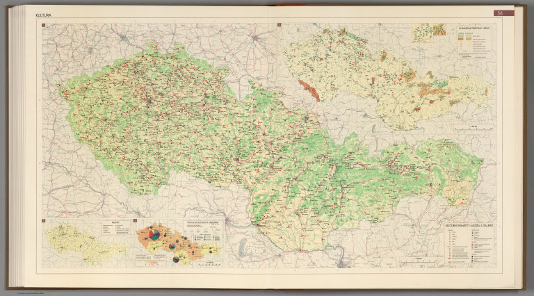
[Götz, Antonín, Československá akademie věd., Czechoslovakia. Ústřední správa geodézie a kartografie.]
Full Title
Culture.
Publisher
Czechoslovakia. Ústřední správa geodézie a kartografie.
Author
[Walcott, Charles D., Plummer, Fred G., USGS (U.S. Geological Survey)]
Full Title
(View) Plate XXXVI. A. Tatoosh Range; Mount St. Helens in Distance. B. Small Lake near Indian Race Track; Second Growth of Mountain Fir and Hemlock.
Publisher
Government Printing Office
Author
[USGS (U.S. Geological Survey), Walcott, Charles D., Plummer, Fred G.]
Full Title
Plate XXXVII. Mount Rainier Forest Reserve, Washington, Showing Distribution of Red or Yellow Fir (Pseudotsuga taxifolia) by Fred G. Plummer. 1899.
Publisher
Government Printing Office
Author
[USGS (U.S. Geological Survey), Walcott, Charles D., Plummer, Fred G.]
Full Title
(View) Plate XXXVIII. A. Tsuga pattoniana. B. Pinus ponderosa. C. Pinus monticola. D. Pseudotsuga taxifolia.
Publisher
Government Printing Office
Author
[USGS (U.S. Geological Survey), Walcott, Charles D., Plummer, Fred G.]
Full Title
Plate XXXIX. Mount Rainier Forest Reserve, Washington, Showing Distribution of Hemlock (Tsuga mertensiana) by Fred G. Plummer. 1899. Julius Bien & Co. Lith. N.Y.
Publisher
Government Printing Office
Author
[USGS (U.S. Geological Survey), Walcott, Charles D., Plummer, Fred G.]
Full Title
(View) Plate XL. A. Larix occidentalis. B. Picea Engelmanni. C. Abies lasicarpa. D. Pinus albicualis.
Publisher
Government Printing Office
Author
[USGS (U.S. Geological Survey), Walcott, Charles D., Plummer, Fred G.]
Full Title
(Diagram) Plate XLI. Diagram Showing Range and Development of Timber Tree Species.
Publisher
Government Printing Office
Author
[USGS (U.S. Geological Survey), Walcott, Charles D., Plummer, Fred G.]
Full Title
Plate XLII. Mount Rainier Forest Reserve, Washington, showing distribution of red cedar (Thuja plicata), by Fred G. Plummer. 1899. Julius Bien & Co. Lith. N.Y.
Publisher
Government Printing Office
Author
[USGS (U.S. Geological Survey), Walcott, Charles D., Plummer, Fred G.]
Full Title
(View) Plate XLIII. A. Pines and Red Fir. B. Red Fir in Cowlitz Bottom.
Publisher
Government Printing Office
Author
[USGS (U.S. Geological Survey), Walcott, Charles D., Plummer, Fred G.]
Full Title
(View) Plate XLIV. A. Maple Grove. B. Yellow Fir 12 1/2 Feet in Diameter.
Publisher
Government Printing Office
Author
[USGS (U.S. Geological Survey), Walcott, Charles D., Plummer, Fred G.]
Full Title
(View) Plate XLV. A. Fir, Maple and Ash Trees. B. Mount Hood, Mountain Fir in Foreground.
Publisher
Government Printing Office
Author
[USGS (U.S. Geological Survey), Walcott, Charles D., Plummer, Fred G.]
Full Title
Plate XLVI. Mount Rainier Forest Reserve, Washington, Showing distribution of yellow pine (Pinus ponderosa), by Fred G. Plummer. 1899. Julius Bien & Co. Lith. N.Y.
Publisher
Government Printing Office
Author
[USGS (U.S. Geological Survey), Walcott, Charles D., Plummer, Fred G.]
Full Title
(View) Plate XLVII. A. Mount Rainier from Goat Mountain. B. Burn with Second Growth.
Publisher
Government Printing Office
Author
[USGS (U.S. Geological Survey), Walcott, Charles D., Plummer, Fred G.]
Full Title
(View) Plate XLVIII. A. Summit of Range in Southern Part of the Reserve, Looking West. B. Headwaters of Tieton River, from Goat Mountain.
Publisher
Government Printing Office
Author
[USGS (U.S. Geological Survey), Walcott, Charles D., Plummer, Fred G.]
Full Title
(View) Plate XLIX. A. Mount Adams. B. Cispus Range, from Goat Mountain.
Publisher
Government Printing Office
Author
[USGS (U.S. Geological Survey), Walcott, Charles D., Plummer, Fred G.]
Full Title
(View) Plate L. A. Recent Cinder Cone on Northern Slope of Mount Adams. B. Mount Adams, with Mountain Fir in Foreground.
Publisher
Government Printing Office
Author
[USGS (U.S. Geological Survey), Walcott, Charles D., Dodwell, Arthur, Rixon, Theodore F.]
Full Title
Plate LI. Part of the Olympic Forest Reserve, Washington, Showing classification of lands. Land classification by Arthur Dodwell and Theodore F. Rixon.
Publisher
Government Printing Office
Author
[USGS (U.S. Geological Survey), Dodwell, Arthur, Rixon, Theodore F., Walcott, Charles D.]
Full Title
(View) Plate LII. A. View of Head of Lillian Creek; Elevation of 5,700 Feet. B. Falls on Creek at Head of Soleduck River.
Publisher
Government Printing Office
Author
[USGS (U.S. Geological Survey), Gannett, Henry, Dodwell, Arthur, Rixon, Theodore F., Walcott, Charles D.]
Full Title
Plate LIII. Part of the Olympic Forest Reserve, Washington, Show in the proportion which red fir bears to the total forest. Land classification by Arthur Dodwell and Theodore F. Rixon.
Publisher
Government Printing Office
Author
[USGS (U.S. Geological Survey), Walcott, Charles D., Dodwell, Arthur, Rixon, Theodore F.]
Full Title
(View) Plate LIV. A. Quillayute Prairie. B. Cedar Timber on Elwha River. Elevation 250 Feet.
Publisher
Government Printing Office
Author
[USGS (U.S. Geological Survey), Dodwell, Arthur, Rixon, Theodore F., Walcott, Charles D.]
Full Title
(View) Plate LV. A. Spruce near Lake Ozette. B. Fir Timber near Forks Prairie.
Publisher
Government Printing Office
Author
[USGS (U.S. Geological Survey), Gannett, Henry, Dodwell, Arthur, Rixon, Theodore F., Walcott, Charles D.]
Full Title
Plate LVI. Part of the Olympic Forest Reserve, Washington, Showing the proportion which hemlock bears to the total forest. 1899. Land classification by Arthur Dodwell and Theodore F. Rixon.
Publisher
Government Printing Office
Author
[USGS (U.S. Geological Survey), Dodwell, Arthur, Rixon, Theodore F., Walcott, Charles D.]
Full Title
(View) LVII. A. Hemlock and Fir Timber on Soleduck River. B. Rocks at La Push, Mouth of Quillayute.
Publisher
Government Printing Office
Author
[USGS (U.S. Geological Survey), Walcott, Charles D., Dodwell, Arthur, Rixon, Theodore F.]
Full Title
(View) Plate LVIII. A. Fir and Hemlock on Soleduck River, 3 Miles above Hot Springs. B. Fir Timber along Edge of Forks Prairie. C. Fir and Hemlock Timber on North Fork Kalawa River. D. Fir Timber.
Publisher
Government Printing Office
Author
[USGS (U.S. Geological Survey), Walcott, Charles D., Gannett, Henry, Dodwell, Arthur, Rixon, Theodore F.]
Full Title
Plate LIX. Part of the Olympic Forest Reserve, Washington, Showing the proportion which cedar bears to the total forest. Land classification by Arthur Dodwell and Theodore F. Rixon.
Publisher
Government Printing Office
Author
[USGS (U.S. Geological Survey), Dodwell, Arthur, Rixon, Theodore F., Walcott, Charles D.]
Full Title
(View) Plate LX. A. Hemlock Timber. B. Fir, Hemlock, and Cedar. C. Hemlock Timber. D. Cedar Tree 18 Feet in Diameter, Decayed in Trunk, on Ozette Indian Reservoir.
Publisher
Government Printing Office
Author
[USGS (U.S. Geological Survey), Gannett, Henry, Dodwell, Arthur, Rixon, Theodore F., Walcott, Charles D.]
Full Title
Plate LXI. Part of the Olympic Forest Reserve, Washington, Showing the proportion which spruce bears to the total forest. Land classification by Arthur Dodwell and Theodore F. Rixon.
Publisher
Government Printing Office
Author
[USGS (U.S. Geological Survey), Dodwell, Arthur, Rixon, Theodore F., Walcott, Charles D.]
Full Title
(View) Plate LXII. A. Looking Southeasterly from East End of Lake Crescent. B. Snow Range at Head of Dungeness River.
Publisher
Government Printing Office
Author
[USGS (U.S. Geological Survey), Walcott, Charles D., Gannett, Henry, Dodwell, Arthur, Rixon, Theodore F.]
Full Title
Plate LXIII. Part of the Olympic Forest Reserve, Washington, Showing the proportion which silver fir bears to the total forest. 1899.
Publisher
Government Printing Office
Author
[USGS (U.S. Geological Survey), Dodwell, Arthur, Rixon, Theodore F., Walcott, Charles D.]
Full Title
(View) Plate LXIV. A. Fir Timber, 100,000 B.M. to the Acre. B. Forks Prairie.
Publisher
Government Printing Office
Author
[USGS (U.S. Geological Survey), Dodwell, Arthur, Rixon, Theodore F., Walcott, Charles D.]
Full Title
(View) Plate LXV. A. B. Fir and Hemlock, along Soleduck River.
Publisher
Government Printing Office
Author
[USGS (U.S. Geological Survey), Walcott, Charles D., Dodwell, Arthur, Rixon, Theodore F.]
Full Title
(View) Plate LXVI. A. Hemlock Tree 4 Feet in Diameter, North of Lake. B. Hemlock Timber. C. View of Cedar, with Hemlock Tree Growing Out of Trunk 20 Feet above the Ground. D. Hemlock Tree 5 Feet in Diameter.
Publisher
Government Printing Office
Author
[USGS (U.S. Geological Survey), Dodwell, Arthur, Rixon, Theodore F., Walcott, Charles D.]
Full Title
(View) Plate LXVII. A. Spruce Tree, 10 Feet in Diameter, on Big River. B. Hemlock Timber. C. Fir Tree, 8 Feet in Diameter. D. Hemlock Timber.
Publisher
Government Printing Office
Author
[USGS (U.S. Geological Survey), Walcott, Charles D., Dodwell, Arthur, Rixon, Theodore F.]
Full Title
(View) Plate LXVIII. A. Spruce 8 Feet in Diameter. B. Hemlock Timber. C. Hemlock Timber near Coast. D. Spruce and Hemlock.
Publisher
Government Printing Office
Author
[USGS (U.S. Geological Survey), Dodwell, Arthur, Rixon, Theodore F., Walcott, Charles D.]
Full Title
(View) Plate LXIX. A. Cedar Trees. B. Hemlock. C. Cedar and Hemlock. D. Hemlock Timber.
Publisher
Government Printing Office
Author
[USGS (U.S. Geological Survey), Walcott, Charles D., Dodwell, Arthur, Rixon, Theodore F.]
Full Title
(View) Plate LXX. A. Cedar Timber between Ozette Lake and the Ocean Beach. B. Hemlock Trees. C. Hemlock Timber. D. Hemlock and Silver Fir Timber on Divide.
Publisher
Government Printing Office
Author
[USGS (U.S. Geological Survey), Walcott, Charles D., Gannett, Henry, Leiberg, John B., Thompson, A.H.]
Full Title
Plate LXXI. Ashland Quadrangle. Oregon. Land Classification and Density of Standing Timber. Julius Bien & Co. Lith. N.Y.
Publisher
Government Printing Office
Author
[USGS (U.S. Geological Survey), Walcott, Charles D., Leiberg, John B.]
Full Title
Plate LXXXII. Part of Southern Oregon Showing Distribution of Yellow Pine and White Bark Pine.
Publisher
Government Printing Office
Author
[USGS (U.S. Geological Survey), Sudworth, George B., Walcott, Charles D.]
Full Title
Plate XC. Dardanelles Quadrangle, California. Land Classification and Density of Standing Timber. Julius Bien & Co. Lith. N.Y.
Publisher
Government Printing Office
Author
[USGS (U.S. Geological Survey), Walcott, Charles D., Sudworth, George B.]
Full Title
Plate CXV. Sonora Quadrangle, California. Land Classification and Density of Standing Timber.
Publisher
Government Printing Office
Author
[USGS (U.S. Geological Survey), Walcott, Charles D., Sudworth, George B.]
Full Title
Plate CXVI. Yosemite Quadrangle, California. Land Classification and Density of Standing Timber. Julius Bien & Co. Lith. N.Y.
Publisher
Government Printing Office
Author
[USGS (U.S. Geological Survey), Walcott, Charles D., Sudworth, George B.]
Full Title
Plate CXVII. Mt. Lyell Quadrangle, California. Land Classification and Density of Standing Timber. Julius Bien & Co. Lith. N.Y.
Publisher
Government Printing Office
Author
[USGS (U.S. Geological Survey), Walcott, Charles D.]
Full Title
(View) Plate CXVIII. A. Oaks in Foothills. B. Abies magnifica, Yosemite National Park.
Publisher
Government Printing Office
|