Who What Where WhenREMOVE |
Author
[Spain, Dirección de Hydrographia, Bauza, Felipe]
Full Title
Carta Esferica Que Comprehende La Costa Ocidental de America Desde Sieto Grados De Latitude Sur Hasta Nueve Grados De Latitude Norte. Levantada De Orden Del Rey N.S. En 1791. Por varios Oficiales De Su Real Armada. Presentada A S.M. Por Mano Del Exmo. Senor Don Antonio Cornel Secretario de Estado y del Despacho Universal de Guerra, encargado del de Marina y de la Direccion general de la Real Armada ... Año de 1800. Felipe Bauzá lo delinió. Fernando Selma la grabó.
Publisher
Direccion de Hydrographia
Author
[Spain, Dirección de Hydrographia, Bauza, Felipe, Mexico Republica]
Full Title
Carta Esferica de las Costas Y Golfo De Californias Llamado Mar De Cortes que Comprende desde et Cabo Corrientes hasta el Puerto de S. Diego Constuida Por les oficiales de la Marina Espanola, y publicado por orn del Exmo Sr. D. Guadalupe Victoria Primer Presidente de la Republica Mexico Ano de 1825. (with 3 inset chart maps).
Publisher
Republica Mexico
Author
U.S. Coast Survey
Full Title
U.S. Coast Survey A.D. Bache, Superintendent Reconnaissance Of The Western Coast Of The United States, Middle Sheet, From San Francisco To Umpquah River. By the Hydrographic Party under the command of Lieut. James Alden U.S.N. Assist. Geographical Positions by G. Davidson Assistant. 1854. Corrected to 1869. Drawn by W.B. McMurtrie; Reduction for engraving by A. Lindenkohl. Engd. by G. McCoy, J. Knight, J.L Hazzard & G.B. Metzeroth. No. 602. Electrotype Copy No. 6 by G. Mathiot U.S.C.S.
Publisher
U.S. Coast Survey
Author
U.S. Coast Survey
Full Title
Tomales Bay California. From a Trigonometrical Survey under the direction of A.D. Bache Superintendent of the Survey Of The Coast Of The United States. Triangulation by G.A. Fairfield and G. Davidson Assts. Coast Survey. Topography by A.F. Rodgers Asst. and J.S. Lawson Sub-Asst. Hydrography by the Party under the command of J. Alden and B.F. Sands Comdrs. U.S.N. Asst. Coast Survey ... Issued in May 1878 C.P. Patterson Superintendent. Verified J.E. Hilgard ... (Tomales Bay) U.S.C. & G.S. No. 5618 Price 25 Cents. Plate No. 1152. Electrotype Copy No. 2 by G. Mathiot U.S.C.S.
Publisher
U.S. Coast Survey
Author
U.S. Coast Survey
Full Title
U.S. Coast Survey A.D. Bache, Superintendent Reconnaissance Of The Western Coast Of The United States From Gray's Harbor To The Entrance of Admiralty Inlet. By the Hydrographic Party under the command of Lieut. James Alden U.S.N. Asst. 1853. Verified H.W. Benham, Capt. of Engrs. Asst. in charge of Office. Redd. Drng. by E. Hergesheimer. Engg. by G. McCoy, E.F. Woodward & W. Smith. Electrotype Copy No. 3 by G. Mathiot U.S.C.S.
Publisher
U.S. Coast Survey
Author
U.S. Coast Survey
Full Title
Bodega Bay, California. From a Trigonometrical Survey under the direction of A.D. Bache Superintendent of the Survey Of The Coast Of The United States. Triangulation by G.A. Fairfield and G. Davidson Assists. Topography by A.F. Rodgers Assist. Hydrography by the party under the command of Comdr. B.F. Sands U.S.N. Asst. (Polyconic Projection). (Date of first publication 1864). U.S. Coast Survey Office. Price 20 Cents. Verified J.E. Hilgard ... Redd. Drng. by F. Fairfax and W.B. McMurtrie. Edgd. by W.A. Thompson and E.H. Sipe. (Bodega Bay) U.S.C. & G.S. 5627.
Publisher
U.S. Coast Survey
Author
U.S. Coast Survey
Full Title
Georgia Strait And Strait Of Juan De Fuca, Washington ... Published Oct. 1898, H.S. Pritchett, Superintendent. Verified: O.H. Tittmann, Assistant in charge of the Office. Gershom Bradford, Assist. and Hydrographic Inspector. United States Coast And Geodetic Survey. Treasury Department ... Corrections from Corps of Engineers, U.S.A., to 1900 ... Electrotype Copy No. 1 U.S.C. & G.S. 6300.
Publisher
U.S. Coast Survey
Author
U.S. Coast Survey
Full Title
San Francisco Entrance, California. Published at Washington, D.C., January, 1907, By The U.S. Coast And Geodetic Survey. O.H. Tittmann, Superintendent. (Date of first publication 1903) ... Corrections from survey by the Corps of Engineers, U.S.A. to October, 1906. United States Of America Department Of Commerce And Labor ... C. & G.S. 5532.
Publisher
U.S. Coast Survey
Author
U.S. Coast Survey
Full Title
San Francisco Entrance, California. Published at Washington, D.C., September, 1903, By The U.S. Coast And Geodetic Survey. O.H. Tittmann, Superintendent ... Corrections from survey by Corps of Engineers U.S.A. to December, 1903. United States Of America Department Of Commerce And Labor ... Andrew B. Graham Co., Lithographers, Washington, D.C. C. & G.S. 5532.
Publisher
U.S. Coast Survey
Author
British Admiralty Hydrographic Office
Full Title
North America - East Coast Approaches To New York From The United States Chart, Published In 1874. Corrected 1877 ... London. Published at the Admiralty, 23rd Octr. 1877; under the Superintendence of Captain F.J. Evans ... Sold by J.D. Potter, Agent for the sale of the Admiralty Charts, 31 Poultry & 11 King Street, Tower Hill. Engraved by Davies & Company. Small corrections ... I.85.
Publisher
British Admiralty Hydrographic Office
Author
U.S. Coast Survey
Full Title
U.S. Coast Survey A.D. Bache Supdt. Preliminary Survey Of The Entrance To Umquah River, Oregon. Geographical position determined by G. Davidson Assist. Hydrography by the Party under the command of Lieut. J. Alden U.S.N. Assist. 1854. U.S. Coast Survey Office. Price 20 Cents. Verified H.W. Benham ... Redd. Drng. by R.S. Lanckoronski. Engd. by J.L. Hazzard and J.J. Knight. Electrotype Copy No. 1 by G. Mathiot U.S.C.S.
Publisher
U.S. Coast Survey
Author
U.S. Coast Survey
Full Title
Port Townshend, Washington Ter. From a Trigonometrical Survey under the direction of A.D. Bache Superintendent of the Survey Of The Coast Of The United States. Triangulation by G. Davidson Asst. Topography by J.S. Lawson Sub Asst. Hydrography by the party under the command of Comdr. James Alden U.S.N. Asst. 1858. U.S. Coast Survey Office. Verified W.R. Palmer ... No. 36. Redd. Drng. by F. Fairfax. Engd. by R.F. Bartle and W. Langran.
Publisher
U.S. Coast Survey
Author
U.S. Coast Survey
Full Title
U.S. Coast Survey A.D. Bache Supdt. Preliminary Survey Of Port Ludlow, Washington Ter. Triangulation by G. Davidson Assistant. Topography by J.S. Lawson Sub-Asst. Hydrography by the Party under the command of Lieut. Comdg. James Alden U.S.N. Asst. 1856. Redd. Drng. by A. Lindenkohl. Engd. by A. Sengteller & W. Ogilvie.
Publisher
U.S. Coast Survey
Author
U.S. Coast Survey
Full Title
U.S. Coast Survey A.D. Bache Supdt. Reconnaissance of Semi-Ah-Moo Bay, Washington Ter. By The Hydrographic Party under the command of Lieut. Comdg. R.M. Cuyler U.S.N. Asst. 1858. U.S. Coast Survey Office. Price 15 Cents. Verified W.R. Palmer ... Redd. Drng. by F. Fairfax. Engd. by A. Petersen and R.F. Bartle. Electrotype Copy No. 1 by G. Mathiot U.S.C.S.
Publisher
U.S. Coast Survey
Author
U.S. Coast Survey
Full Title
Preliminary Chart Of Entrance To Koos Bay, Oregon. From a Trigonometrical Survey under the direction of A.D. Bache Superintendent of the Survey Of The Coast Of The United States. Triangulation, Topography and Hydrography by Jas. S. Lawson Assist. Coast Survey. 1862. U.S. Coast Survey Office. Verified J.E. Hilgard ... No. 43. Redd. Drng. by H. Lindenkohl & F. Fairfax. Engd. by H.C. Evans & C.T. Klakring.
Publisher
U.S. Coast Survey
Author
U.S. Coast Survey
Full Title
U.S. Coast Survey A.D. Bache Supdt. Cape Flattery And Nee-Ah Harbor, Washington. Topography by G. Davidson Assistant U.S.C.S. Hydrography by the Party under the command of Lieut. James Alden U.S.N. Asst. 1853. U.S. Coast Survey Office. Price 15 Cents. Verified H.W. Benham ... Redd. Drng. by J. Lambert. Engd. by S. Siebert & J. Young. Electrotype Copy No. 1 by G. Mathiot U.S.C.S.
Publisher
U.S. Coast Survey
Author
U.S. Coast Survey
Full Title
U.S. Coast Survey A.D. Bache Supdt. Reconnaissance of Blakely Harbor, Washington Ter. By the Hydrographic party under the command of Lieut. Comdg. J. Alden U.S.N. Asst. 1856. U.S. Coast Survey Office. Price 15 Cents. Verified A.P. Hill ... Drawn by G. Farquhar. Engd. by J.J. Knight.
Publisher
U.S. Coast Survey
Author
U.S. Coast Survey
Full Title
U.S. Coast Survey A.D. Bache Supdt. Reconnaissance of Olympia Harbor, Washington Ter. By the Hydrographic Party under the command of Lieut. Comdg. J. Alden U.S.N. Asst. 1856. No. 56. Redd. Drng. by F. Fairfax. Engd. by S.W. Bradley & App. F.W. Benner.
Publisher
U.S. Coast Survey
Author
U.S. Coast Survey
Full Title
U.S. Coast Survey A.D. Bache Supdt. Reconnaissance of False Dungeness Harbor, Washington. By the Hydrographic Party under the command of Lieut. James Alden U.S.N. Asst. 1853. No. 53. Redd. Drng. by J.R. Key. Engd. by W. Smith & App. J.S. Pettit. (with) U.S. Coast Survey A.D. Bache Supdt. Reconnaissance of New Dungeness Harbor, Washington. Topography by J.S. Lawson Sub-Assist. Hydrography by the party under the command of Lieut. Comdg. J. Alden U.S.N. Assistant. 1856. Redd. Drng. by W.P. Schultz. Engd. by S.W. Bradly & App. W.A. Thompson.
Publisher
U.S. Coast Survey
Author
U.S. Coast Survey
Full Title
(J No. 3) U.S. Coast Survey A.D. Bache Supdt. Reconnaissance Of Smith's Or Blunt's Island, Washington. By the Hydrographic Party under the command of Lieut. James Alden U.S.N. Asst. 1854. No. 43. Redd. Drng. by W.T. Martin. Engd. by C.A. Knight & App. R.F. Bartle.
Publisher
U.S. Coast Survey
Author
[Hood, Washington, Graham, Maj. J.D.]
Full Title
A Map Of The Extremity Of Cape Cod Including the Townships of Provincetown & Truro: A Chart Of Their Sea Coast And Of Cape Cod Harbour, State of Massachusetts. Executed under the direction of Major J.D. Graham U.S. Top. Engs. During portions of the years 1833,'34, &'35 ... W.J. Stone Sc. Wash. Surveyed And Projected By J.D. Graham ... Drawn From The Original Projects And Notes, By J.E. Johnston ... A.A. Humphreys .... J.. Macomb ... W.R. Palmer ... Reduced from the original in the Bureau of U.S. Topographical Engineers, Washington, by Wash: Hood 1836.
Publisher
U.S.
Author
[Hood, Washington, Graham, Maj. J.D.]
Full Title
(Composite of) A Map Of The Extremity Of Cape Cod Including the Townships of Provincetown & Truro: A Chart Of Their Sea Coast And Of Cape Cod Harbour, State of Massachusetts. Executed under the direction of Major J.D. Graham U.S. Top. Engs. During portions of the years 1833,'34, &'35 ... W.J. Stone Sc. Wash. Surveyed And Projected By J.D. Graham ... Drawn From The Original Projects And Notes, By J.E. Johnston ... A.A. Humphreys .... J.. Macomb ... W.R. Palmer ... Reduced from the original in the Bureau of U.S. Topographical Engineers, Washington, by Wash: Hood 1836.
Publisher
U.S.
Author
Blunt, E. & G.W.
Full Title
Chart Of The South Atlantic Ocean, From the Equator to 65º South Latitude According to the Latest Surveys & Observations. New York, Published by E. & G.W. Blunt, 154 Water St. Corner of Maiden Lane. 1834. Entered ... 1834 By Edmund & George W. Blunt ... New York. Engraved by W. Hooker. (with) seven inset maps listed in Notes.
Publisher
E. & G.W. Blunt
Author
Norie, J.W.
Full Title
A New Chart of The Pacific Ocean, Exhibiting The Western Coast of America, From Cape Horn To Beerings Strait, The Eastern Shores of Asia Including Japan, China and Australia, and all the numerous Islands and known Dangers Situated in Polynesia and Australasia, Correctly Drawn And Regulated according to the most Approved and Modern Surveys and Astronomical Observations By J.W. Norie, Hydrographer, &c.&c. Additions 1836. Stephenson, Engraver. London. Published ... October 1st 1825, by J.W. Norie & Co. (with) seven inset maps listed in Notes. (Northern Sheet)
Publisher
J.W. Norie & Co.
Author
Norie, J.W.
Full Title
A New Chart of The Pacific Ocean, Exhibiting The Western Coast of America, From Cape Horn To Beerings Strait, The Eastern Shores of Asia Including Japan, China and Australia, and all the numerous Islands and known Dangers Situated in Polynesia and Australasia, Correctly Drawn And Regulated according to the most Approved and Modern Surveys and Astronomical Observations By J.W. Norie, Hydrographer, &c.&c. Additions 1836. Stephenson, Engraver. London. Published ... October 1st 1825, by J.W. Norie & Co. (with) seven inset maps listed in Notes. (Southern Sheet)
Publisher
J.W. Norie & Co.
Author
Norie, J.W.
Full Title
(Composite of) A New Chart of The Pacific Ocean, Exhibiting The Western Coast of America, From Cape Horn To Beerings Strait, The Eastern Shores of Asia Including Japan, China and Australia, and all the numerous Islands and known Dangers Situated in Polynesia and Australasia, Correctly Drawn And Regulated according to the most Approved and Modern Surveys and Astronomical Observations By J.W. Norie, Hydrographer, &c.&c. Additions 1836. Stephenson, Engraver. London. Published ... October 1st 1825, by J.W. Norie & Co. (with) seven inset maps listed in Notes. (Northern and Southern Sheets)
Publisher
J.W. Norie & Co.
Author
Norie, J.W.
Full Title
(Tasman Sea and New Zealand) (with) eight inset maps listed in Notes. London ... July 1st 1828, by J.W. Norie & Co. ... Leadenhall Street.
Publisher
J.W. Norie & Co.
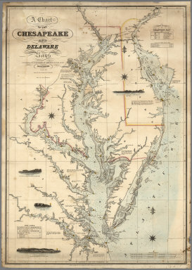
Author
Lucas, Fielding Jr.
Full Title
A Chart of the Chesapeake And Delaware Bays Compiled And Published By Fielding Lucas Junr. Baltimore. Corrected_1862. Engraved by John and William W. Warr Philadelphia. Sold by Lucas Brothers. Drawn by F. Lucas Jr. Entered ... 1852 by Fielding Lucas Jr. ... Maryland.
Publisher
Fielding, Lucas Jr.
Author
[British Admiralty, Alden, James]
Full Title
N. America West Coast. San Francisco Harbour Surveyed by Lieut. James Alden U.S. Navy 1856. London. Published at the Admiralty 20th. Oct. 1860, under the Superintendence of Captn. Washington, R.N., F.R.S. Hydrographer. Corrections to Augt. 63 ... Engraved by J. & C. Walker. (with 4 profile views). (on lower right margin) 591.
Publisher
British Admiralty
Author
British Admiralty
Full Title
America East Coast: Charleston Harbour, from the United States Coast Survey 1866. The notations in fine line are from U.S. Governt. Report of 1882. Engraved by J. & C. Walker. London. Published at the Admiralty April 1st. 1869 under the Superintendence of Captn. G.H. Richards, R.N., F.R.S. Hydrographer. Corrections and additions to Nov. 1881. (on lower margin) I 83 XII.84. 2806. (inset profile view) City of Charleston.
Publisher
British Admiralty
Author
Norie, J.W.
Full Title
A New Chart of the Windward Passages Containing the Islands of Jamaica, St. Domingo, with Part of Cuba, &c. Drawn from the latest English, Spanish & French Surveys, by J.W. Norie, Hydrogr. 1836. A New Edition. Corrected to 1846.
Publisher
J.W. Norie & Co.
Author
[Norie, J.W., Hobbs, J.S., Wilson, Charles]
Full Title
A General Chart of the Indian and Part of the Pacific Oceans, Shewing the Various Passages to & from China, Australia, New Zealand, &c. Carefully Constructed & Compiled from the most approved Observations and Modern Surveys, by J.S. Hobbs, F.R.G.S. Hydrographer. London, Published as the Act directs, March 1st 1850 by Charles Wilson, Late J.W. Norie & Wilson, at the Navigation Warehouse and Naval Academy, No. 157 Leadenhall Street. Additions 1870.
Publisher
Charles Wilson
Author
Bellin, Jacques Nicolas, 1703-1772
Full Title
Plan de la Forteresse et Bourg, de l'Isle de Ste. Helene.
Publisher
J.N. Bellin
Author
Bellin, Jacques Nicolas, 1703-1772
Full Title
Carte de L'Europe.
Publisher
J.N. Bellin
Author
Bellin, Jacques Nicolas, 1703-1772
Full Title
Isles Britanniques.
Publisher
J.N. Bellin
Author
Bellin, Jacques Nicolas, 1703-1772
Full Title
Carte de I'Angleterre.
Publisher
J.N. Bellin
Author
Bellin, Jacques Nicolas, 1703-1772
Full Title
Carte des entrees de la Tamise.
Publisher
J.N. Bellin
Author
Bellin, Jacques Nicolas, 1703-1772
Full Title
Plan de la Ville de Londres et aes Fauxbourga.
Publisher
J.N. Bellin
Author
Bellin, Jacques Nicolas, 1703-1772
Full Title
Carte de I'Isle de Wight.
Publisher
J.N. Bellin
Author
Bellin, Jacques Nicolas, 1703-1772
Full Title
Plan de Portsmouth et environs : Avoc les Rades de Spit Head et de Ste. Helene.
Publisher
J.N. Bellin
Author
Bellin, Jacques Nicolas, 1703-1772
Full Title
Carto de I'isle de Portsoy et havro de Portsmouth.
Publisher
J.N. Bellin
Author
Bellin, Jacques Nicolas, 1703-1772
Full Title
Plan du havre de Rye et de ses Environs.
Publisher
J.N. Bellin
Author
Bellin, Jacques Nicolas, 1703-1772
Full Title
Carte de la Baye et Port de Plimouth. Engraved by) Croisey S(culp.)
Publisher
J.N. Bellin
Author
Bellin, Jacques Nicolas, 1703-1772
Full Title
Plan des villa et Citadelle de Plymouth.
Publisher
J.N. Bellin
Author
Bellin, Jacques Nicolas, 1703-1772
Full Title
Plan de la Ville d'Yarmouth et Environs.
Publisher
J.N. Bellin
Author
Bellin, Jacques Nicolas, 1703-1772
Full Title
Carte de I'Ecosse.
Publisher
J.N. Bellin
|