Who What Where WhenREMOVEWHAT
|
Author
[Wilkes, Charles, United States Exploring Expedition]
Full Title
Ahii (Ahe) and Manhii (Turipaoa) or Peacock and Wilson Islands, by the U.S.Ex.Ex. 1839.
Publisher
C. Sherman
Author
[Wilkes, Charles, United States Exploring Expedition]
Full Title
Map of Hawaiian Group or Sandwich Islands, by the U.S.Ex.Ex. 1841.
Publisher
C. Sherman
Author
[Wilkes, Charles, United States Exploring Expedition]
Full Title
Harbours of Papieti, Toanoa, Papaoa and Matavai Bay with the Ship Channel through Reef, Island of Tahiti, by the U.S.Ex.Ex. 1839.
Publisher
C. Sherman
Author
[Wilkes, Charles, United States Exploring Expedition]
Full Title
Deans, Krusensterns, and Lazareff Islands, by the U.S.Ex.Ex. 1839.
Publisher
C. Sherman
Author
[Wilkes, Charles, United States Exploring Expedition]
Full Title
Colsee-ed Harbour, Hoods Canal, Oregon Territory, by the U.S.Ex.Ex. 1841. Suquamish Harbour, Hoods Canal, Oregon Territory, by the U.S.Ex.Ex. 1841.
Publisher
C. Sherman
Author
[Wilkes, Charles, United States Exploring Expedition]
Full Title
Channel on the North Side of Vanu Levu from Aramula Passage to Muthuata Island, Feejee (Fiji) Islands, by the U.S.Ex.Ex. 1840.
Publisher
C. Sherman
Author
[Wilkes, Charles, United States Exploring Expedition]
Full Title
North Side of Viti Levu with the Ship Passages and Anchorages from Sakau Bay to the Island of Ovolau, Feejee (Fiji) Islands, by the U.S.Ex.Ex. 1840.
Publisher
C. Sherman
Author
[Wilkes, Charles, United States Exploring Expedition]
Full Title
M'Bua or Sandalwood Bay, Island of Vanua Levu, Feejee (Fiji) Group by the U.S.Ex.Ex. 1840.
Publisher
C. Sherman
Author
[Wilkes, Charles, United States Exploring Expedition]
Full Title
New Dunginess Roads and Budds Harbour, Straits of Fuca, Oregon Territory, the U.S.Ex.Ex. 1841.
Publisher
C. Sherman
Author
[Wilkes, Charles, United States Exploring Expedition]
Full Title
Grays Harbour, Oregon Territory by the U.S.Ex.Ex. 1841.
Publisher
C. Sherman
Author
[Wilkes, Charles, United States Exploring Expedition]
Full Title
Chart of the Harbour of Waiakea, Island of Hawaii, Surveyed by the U.S.Ex.Ex. 1841.
Publisher
C. Sherman
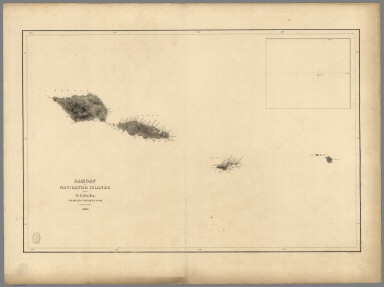
Author
[Wilkes, Charles, United States Exploring Expedition]
Full Title
Samoan or Navigator Islands by the U.S. Ex.Ex., Charles Wilkes Esq. Commander 1839.
Publisher
C. Sherman
Author
[Wilkes, Charles, United States Exploring Expedition]
Full Title
Harbour of Pago Pago, Island of Tutuila by the U.S.Ex.Ex. 1839.
Publisher
C. Sherman
Author
[Wilkes, Charles, United States Exploring Expedition]
Full Title
Port Ludlow, Hoods Canal, Oregon Territory by the U.S.Ex.Ex. 1841. Port Gamble, Hoods Canal, Oregon Territory by the U.S.Ex.Ex. 1841.
Publisher
C. Sherman
Author
[Wilkes, Charles, United States Exploring Expedition]
Full Title
St. Juan Harbour, Straits of Fuca, Vancouver Island by the U.S.Ex.Ex. 1841. Scarborough Harbour, Straits of Fuca, Oregon Territory by the U.S.Ex.Ex. 1841. Port Discovery, Straits of Fuca, Oregon Territory by the U.S.Ex.Ex. 1841.
Publisher
C. Sherman
Author
[Wilkes, Charles, United States Exploring Expedition]
Full Title
Channel of the North Side of Vanua Levu from Muthuata Island to Ivaca Peak, Feejee (Fiji) Islands by the U.S.Ex.Ex. 1840.
Publisher
C. Sherman
Author
[Wilkes, Charles, United States Exploring Expedition]
Full Title
Channel on the South Western Side of Vanua Levu from Ivaca Peak to Savu Savu Bay, Feejee (Fiji) Islands by the U.S.Ex.Ex. 1840.
Publisher
C. Sherman
Author
[Wilkes, Charles, United States Exploring Expedition]
Full Title
Island of Upolu, Samoan Group by the U.S. Ex.Ex. 1839.
Publisher
C. Sherman
Author
[Wilkes, Charles, United States Exploring Expedition]
Full Title
Scabock Harbour, Hoods Canal, Oregon Territory by the U.S.Ex.Ex. 1841. Hooetzen Harbour, Hoods Canal, Oregon Territory by the U.S.Ex.Ex. 1841. Tzu-Sa-Ted Cove, Hoods Canal, Oregon Territory by the U.S.Ex.Ex. 1841.
Publisher
C. Sherman
Author
[Paullin, Charles O., Wright, John K.]
Full Title
Plate 1. Natural Environment: Natural Regions, Glaciated Areas, Ocean Currents. Major Geographical Regions. Cultivated Crops. Winds and Sailing Routes - Winter. Winds and Sailing Routes - Summer.
Publisher
[Carnegie Institution of Washington, American Geographical Society of New York]
Author
McGraw-Hill Book Company
Full Title
World Political.
Publisher
General Drafting Co., Inc.
Author
McGraw-Hill Book Company
Full Title
Atlantic Ocean.
Publisher
General Drafting Co., Inc.
Author
McGraw-Hill Book Company
Full Title
Indian and Pacific Oceans Physical.
Publisher
General Drafting Co., Inc.
Author
Bartholomew, J. G.
Full Title
Natural Vegetation & Ocean Currents. Forms of Cultivation. Temperature of Ocean Surface.
Publisher
George Newnes, Limited
Author
Johnston, A. Keith
Full Title
Chart of the World Showing the Forms and Directions of the Ocean Currents.
Publisher
William Blackwood & Sons
Author
[U.S. Geological Survey, Alpha, Tau Rho, Gerin, Marybeth, Joyce, James M.]
Full Title
Oblique Map of the Gulf of Alaska.
Publisher
U.S. Geological Survey
Author
[U.S. Geological Survey, Alpha, Tau Rho]
Full Title
The Aleutian-Kamchatka Convergence, North Pacific Ocean.
Publisher
U.S. Geological Survey
Author
[U.S. Geological Survey, Alpha, Tau Rho]
Full Title
Central Aleutian Arc, Alaska.
Publisher
U.S. Geological Survey
Author
[U.S. Geological Survey, Alpha, Tau Rho, Winegard, Charles I.]
Full Title
Eastern Aleutian Trench and Northern Gulf of Alaska.
Publisher
U.S. Geological Survey
Author
[U.S. Geological Survey, Alpha, Tau Rho]
Full Title
A Part of the Eastern Aleutian Trench.
Publisher
U.S. Geological Survey
Author
[U.S. Geological Survey, Alpha, Tau Rho, Scholl, David W., Vallier, T.L.]
Full Title
Amlia Corridor, Alaska.
Publisher
U.S. Geological Survey
Author
[U.S. Geological Survey, Alpha, Tau Rho, Morley, James M., Eittreim, Stephen]
Full Title
Barrow Canyon, Alaska.
Publisher
U.S. Geological Survey
Author
[U.S. Geological Survey, Alpha, Tau Rho, Gerin, Marybeth]
Full Title
Oblique Map of the Beaufort Sea and the Brooks Range of Alaska.
Publisher
U.S. Geological Survey
Author
[U.S. Geological Survey, Alpha, Tau Rho]
Full Title
Bering Canyon, Aleutian Islands, Alaska.
Publisher
U.S. Geological Survey
Author
[U.S. Geological Survey, Alpha, Tau Rho]
Full Title
Oblique Map of the Bering Sea.
Publisher
U.S. Geological Survey
Author
[U.S. Geological Survey, Alpha, Tau Rho]
Full Title
Northern Bering Sea.
Publisher
U.S. Geological Survey
Author
[U.S. Geological Survey, Alpha, Tau Rho]
Full Title
Physiography Bering Sea Shelf, Alaska.
Publisher
U.S. Geological Survey
Author
[U.S. Geological Survey, Alpha, Tau Rho, Scholl, D.W., Buffington, E.C.]
Full Title
Physiography and Cross Sections Bering Sea Shelf, Alaska.
Publisher
U.S. Geological Survey
Author
[U.S. Geological Survey, Alpha, Tau Rho, Detterman, Janis S., Morley, James M.]
Full Title
Pre-Tertiary Rocks Bering Sea Shelf, Alaska.
Publisher
U.S. Geological Survey
Author
[U.S. Geological Survey, Alpha, Tau Rho, Scholl, D.W., Marlow, M.S., Cooper, A.K.]
Full Title
Pre-Tertiary Rocks Southern Bering Sea Shelf, Alaska.
Publisher
U.S. Geological Survey
Author
[U.S. Geological Survey, Alpha, Tau Rho]
Full Title
Buldir Depression, Aleutian Islands, Alaska.
Publisher
U.S. Geological Survey
Author
[U.S. Geological Survey, Alpha, Tau Rho]
Full Title
Emperor Seamounts, North Pacific Ocean.
Publisher
U.S. Geological Survey
Author
[U.S. Geological Survey, Alpha, Tau Rho, Vallier, T.L.]
Full Title
Oblique Map of Hess Rise and Vicinity, North-Central Pacific Ocean.
Publisher
U.S. Geological Survey
Author
[U.S. Geological Survey, Alpha, Tau Rho]
Full Title
Icy Bay, Alaska.
Publisher
U.S. Geological Survey
Author
[U.S. Geological Survey, Alpha, Tau Rho]
Full Title
Kayak Trough, Gulf of Alaska.
Publisher
U.S. Geological Survey
Author
[U.S. Geological Survey, Alpha, Tau Rho]
Full Title
Nuka Bay, Alaska.
Publisher
U.S. Geological Survey
Author
[U.S. Geological Survey, Alpha, Tau Rho]
Full Title
Pamplona Ridge, Gulf of Alaska.
Publisher
U.S. Geological Survey
Author
[U.S. Geological Survey, Alpha, Tau Rho]
Full Title
Passage Canal, Alaska.
Publisher
U.S. Geological Survey
Author
[U.S. Geological Survey, Alpha, Tau Rho]
Full Title
Pribilof Canyon, Bering Sea, Alaska.
Publisher
U.S. Geological Survey
|