Browse All

1864 Richardson's Map Of West Virginia. Separate Map Richardson's Map Of West Virginia Showin … |

1864 Cover: Oil District Venango, Crawford & … Pocket Map (Covers to) Map Of The Oil District Vena … |

1864 Map Of The Oil District Venango, Crawfor … Pocket Map Map Of The Oil District Venango, Crawfor … |

1865 Map Of The Oil District Of Pennsylvania. Pocket Map Colton's Map Of The Oil District Of Penn … |

1866 Cover: Howe's Oil District of Pennsylvan … Pocket Map (Covers to) Howe's Map Of The Oil Distri … |

1866 Howe's Map Of The Oil District Of Pennsy … Pocket Map Howe's Map Of The Oil District Of Pennsy … |

1865 Cover: Atlas, oil regions, Pennsylvania. Regional Atlas (Covers to) Atlas of the oil region of P … |

1865 Title Page: Atlas, oil regions, Pennsylv … Regional Atlas (Title Page to) Atlas of the oil region … |

1865 Venango Co., Pa. Regional Atlas Outline map of Venango Co., Pa. from act … |

1865 Contents: Atlas, oil regions, Pennsylvan … Regional Atlas (Contents to) Atlas of the oil region of … |

1865 Distance Table: Atlas, oil regions, Penn … Regional Atlas (Distance Table to) Atlas of the oil reg … |

1865 Text Page: Atlas, oil regions, Pennsylva … Regional Atlas (Text Page to) Atlas of the oil region o … |

1865 Text Page: Atlas, oil regions, Pennsylva … Regional Atlas (Text Page to) Atlas of the oil region o … |

1865 Text Page: Atlas, oil regions, Pennsylva … Regional Atlas (Text Page to) Atlas of the oil region o … |

1865 Text Page: Atlas, oil regions, Pennsylva … Regional Atlas (Text Page to) Atlas of the oil region o … |

1865 Franklin. Regional Atlas Franklin. Entered ... 1865 ... Southern … |

1865 French Creek Township. Regional Atlas Plan of French Creek Township. (with) Ut … |

1865 Sandy Creek Township. Regional Atlas Plan of Sandy Creek Township. Entered .. … |

1865 Sugar Creek Township. Regional Atlas Plan of Sugar Creek Township. Entered .. … |

1865 Cranberry Township. Regional Atlas Plan of Cranberry Township. (with) Plan … |
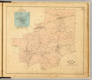
1865 Plum Township. Regional Atlas Plan of Plum Township. (with) Plan of Su … |

1865 Pine Grove Township. Regional Atlas Plan of Pine Grove Township. Entered ... … |

1865 Richland Township. Regional Atlas Plan of Richland Township. (with) Emlent … |

1865 Oakland Township. Regional Atlas Plan of Oakland Township. (with) Dempsey … |

1865 Rockland Township. Regional Atlas Plan of Rockland Township. (with) Plan o … |

1865 Irwin Township. Regional Atlas Plan of Irwin Township. (with) Mechanics … |

1865 Clinton Township. Regional Atlas Plan of Clinton Township. Entered ... 18 … |

1865 Scrub Grass Township. Regional Atlas Plan of Scrub Grass Township. Entered .. … |

1865 Canal Township. Regional Atlas Plan of Canal Township. Entered ... 1865 … |

1865 Jackson Township. Regional Atlas Plan of Jackson Township. (with) Coopert … |

1865 Cherrytree Township. Regional Atlas Plan of Cherrytree Township. (with) Plan … |

1865 Allegheny Township. Regional Atlas Plan of Allegheny Township. (with) Pleas … |

1865 President Township. Regional Atlas Plan of President Township. Entered ... … |

1865 Harmony, Hickory, Kingsley, Tionesta tow … Regional Atlas (Plan of Harmony, Hickory, Kingsley and … |

1865 Cornplanter Township. Regional Atlas Map of Cornplanter Township. (with) Plan … |

1865 Cherry Run, Plumer. Regional Atlas Plan of lands on Cherry Run. (with) Plum … |

1865 Oil Creek 1. Regional Atlas Sectional plan of Oil Creek. No. 1. Ente … |

1865 Oil Creek 2. Regional Atlas Sectional plan of Oil Creek. No. 2. Ente … |

1865 Oil Creek 3. Regional Atlas Sectional plan of Oil Creek. No. 3. Ente … |

1865 Oil Creek 4. Regional Atlas Sectional plan of Oil Creek. No. 4. Ente … |

1865 Oil Creek 5. Regional Atlas Sectional plan of Oil Creek. No. 5. Ente … |

1865 Titusville. Regional Atlas Titusville. Entered ... 1865 ... Souther … |

1865 Oil Creek, Titusville-Oil Creek Lake. Regional Atlas Plan of Oil Creek from Titusville to Oil … |

1865 Oil Creek branches. Regional Atlas Plan of East Branch of Oil Creek, Warren … |

1865 Allegheny River. Regional Atlas Plan of Allegheny River beginning at Cla … |

1865 Allegheny River. Regional Atlas Plan of Allegheny River (below Franklin … |

1865 Allegheny R. bends. Regional Atlas Plan of Walnut & Henry's bends, Alleghen … |

1865 Allegheny River. Regional Atlas Plan of Allegheny River from President t … |

1865 Warren Co. oil territory. Regional Atlas Plan of oil territory, in Warren County. … |

1865 Humboldt Mining & Ref. Co. Regional Atlas Index map of the various properties. Pro … |