|
|
REFINE
Browse All : Physical of United States
1-31 of 31
Author
[Bayer, Herbert, Container Corporation of America]
Full Title
U.S.A. Physiographic.
Publisher
Container Corporation of America
Author
[Bayer, Herbert, Container Corporation of America]
Full Title
Central U.S.A.
Publisher
Container Corporation of America
Author
[Bayer, Herbert, Container Corporation of America]
Full Title
Western U.S.A.
Publisher
Container Corporation of America
Author
Woodbridge, William C.
Full Title
Physical Map Of The United States. Adapted To Woodbridge's Geography. Figures 1, 2, 3, 4, Near Rivers, Indicate Their Ranks. Entered .. . 1843, by W.C. Woodbridge ... Massachusetts. Hartford. Published By Wm. Jas. Hamersley. Includes 5 inset maps.
Publisher
Wm. Jas. Hamersley
Author
Woodbridge, William C.
Full Title
Physical And Political Map Of The N. Eastern States. Adapted To Woodbridge's Geography. Drawn & Engd. by Story & Atwood. N. York. Entered .. . 1843, by W.C. Woodbridge ... Massachusetts. Hartford. Published By Wm. Jas. Hamersley.
Publisher
Wm. Jas. Hamersley
Author
Woodbridge, William C.
Full Title
Physical & Political Map Of The Southern Division Of the United States. Adapted To Woodbridge's Geography. Entered .. . 1843, by W.C. Woodbridge ... Massachusetts. Hartford. Published By Wm. Jas. Hamersley. (inset map) Vicinity of Charleston. (inset map) Vicinity of New Orleans.
Publisher
Wm. Jas. Hamersley
Author
Woodbridge, William C.
Full Title
Physical Map Of The United States. Adapted To Woodbridge's Geography. Figures 1. 2, 3, 4., near Rivers Indicated their Rank. Entered ... 1843, by W.C. Woodbridge ... Massachusetts. Hartford. Published By Wm. Jas. Hamersley. (to accompany) Modern Atlas, Physical, Political And Statistical; Exhibiting On Separate Maps ... Includes 4 inset maps.
Publisher
Belknap and Hamersley
Author
Woodbridge, William C.
Full Title
Physical & Political Map Of The N. Eastern States. Adapted To Woodbridge's Geography. Drawn and Engrd. by Story & Atwood. N. York. Entered ... 1843, by W.C. Woodbridge ... Massachusetts. Hartford. Published By Wm. Jas. Hamersley. (to accompany) Modern Atlas, Physical, Political And Statistical; Exhibiting On Separate Maps ...
Publisher
Belknap and Hamersley
Author
Gannett, Henry, 1846-1914
Full Title
Mean annual temperature ... Hypsometric sketch. By Henry Gannett. Copyright, 1883, by Charles Scribner's Sons.
Publisher
Charles Scribner's Sons
Author
Raisz, Erwin
Full Title
Landforms of the United States, to accompany Atwood's Physiographic Provinces of the United States.
Publisher
Edwin Raisz
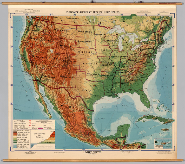
Author
[Colby, Charles C., Wenschow]
Full Title
United States with Mexico.
Publisher
Denoyer-Geppert Company
Author
Haack, Hermann
Full Title
Vereinigte Staaten und Mittleamerika.
Publisher
Justus Perthes
Author
Haack-Painke
Full Title
United States/Vereinigte Staaten.
Publisher
Justus Perthes
Author
Klett-Perthes
Full Title
United States of America.
Publisher
Justus Perthes Verlag Gotha GmbH
Author
Denoyer-Geppert Company
Full Title
Sectional Map of the United States, Southwestern/Northwestern United States.
Publisher
Denoyer-Geppert Company
Author
Lobeck, A.K.
Full Title
A Phsiographic Diagram of the United States, (Provisional Edition).
Publisher
A.J. Nystrom & Co.
Author
[Bory de Saint-Vincent, M. (Jean Baptiste GeneviFve Marcellin), 1778-1846, Desmarest, Nicolas, 1725-1815, Vincent]
Full Title
Carte du courant qui sort par le Canal de Bahama, appele Gulf-Stream. Grave par Berthe. (A Paris, Chez Mme. veuve Agasse, Imprimeur-Libraire, rue des Poitevins, no. 6. M.DCCCXXVII)
Publisher
Veuve Agasse
Author
[Bory de Saint-Vincent, M. (Jean Baptiste GeneviFve Marcellin), 1778-1846, Desmarest, Nicolas, 1725-1815, Vincent]
Full Title
Carte des montagnes coupees par des rivieres, situees en Virginie et en Pensylvanie. Grave par Berthe. (A Paris, Chez Mme. veuve Agasse, Imprimeur-Libraire, rue des Poitevins, no. 6. M.DCCCXXVII)
Publisher
Veuve Agasse
Author
[Guyot, A. (Arnold), 1807-1884, Schott, Charles A. (Charles Anthony), 1826-1901, United States. Census Office]
Full Title
Hypsometric sketch of the United States. The level curves of 400 and 800 feet of elevation constructed by A. Guyot. The level curves of 2000, 4000 and 8000 feet of elevation constructed by Chas. A. Schott, Asst., U.S. Coast Survey. (Julius Bien, Lith., 1874)
Publisher
U.S.
Author
[Scovel, James L., O'Brien, Emmett J]
Full Title
Index Map. Locations are Approximate. (inset maps) Alaska, Hawaiian Islands, and Manat. (to accompany) Atlas of Landforms. James L Scovel; Emmett J O'Brien; J C McCormack, (Major); R.B. Chapman; Department of Earth, Space and Grafic Sciences; United States Military Academy, West Point, New York. John Wiley and Sons Inc., New York. London. Sydney.
Publisher
John Wiley & Sons Inc.
Author
[Paullin, Charles O., Wright, John K.]
Full Title
Plate 2. Physical Geography and Vegetation. Relief; Soil Regions. Physical Divisions. Vegetation Regions.
Publisher
[Carnegie Institution of Washington, American Geographical Society of New York]
Author
McGraw-Hill Book Company
Full Title
United States Physical.
Publisher
General Drafting Co., Inc.
Author
[Drioux, Claude-Joseph, Leroy, Charles]
Full Title
Amerique du Nord : Carte physique et economique ; Relief du sol. Par M.Mrs. Drioux et Ch. Leroy. Grave par F. Dufour ... Dessine par Vilpou. Librairie Classique Eugene Belin Paris. (to accompany) Atlas Universel Et Classique De Geographie ...1886. (insets) Etats - Unis ; Amerique Centrale ; Projet du Canal de l'Isthme de Panama.
Publisher
Eugene Belin
Author
USSR (Union of Soviet Socialist Republics).
Full Title
194-195. United States of America. The World Atlas.
Publisher
USSR
Author
USSR (Union of Soviet Socialist Republics).
Full Title
197-198. United States of America, North East. The World Atlas.
Publisher
USSR
Author
USSR (Union of Soviet Socialist Republics).
Full Title
200-201. United States of America, North East Central. The World Atlas.
Publisher
USSR
Author
USSR (Union of Soviet Socialist Republics).
Full Title
205. United States of America, Middle Atlantic. The World Atlas.
Publisher
USSR
Author
Marschner, Francis J.
Full Title
(Section Title Page) Atlas of American Agriculture. Land Relief. Contribution of the Bureau of Agricultural Economics, A.G. Black, Chief. By F.J. Marschner, Research Assistant. United States Government Printing Office, Washington: 1936.
Publisher
U.S. Department of Agriculture
Author
[Tardieu, P.F., Tardieu, P. (Pierre Antoine), 1784-1869]
Full Title
(Composite of) A Map of Louisiana and Mexico. Carte de la Louisiane et du Mexique, Dressee par P. Tardieu fils aine, Gravee par P.A.F. Tardieu pere. Paris 1820. A Paris, chez: P.A.F. Tardieu, Place de l'Estrapade No. 34. C. Piequet, Geographe Graveur, Quai Conti No. 17. J. Goujon, Marchand de Cartes Geographiques, Rue du Bac No. 6. New York. Anthy. Girard , Mercht. Agent for the Author. Ecrit par Richomme.
Publisher
J. (Jean) Goujon, 1793-1826
Author
[Tardieu, P.F., Tardieu, P. (Pierre Antoine), 1784-1869]
Full Title
A Map of Louisiana and Mexico (northern portion). Carte de la Louisiane et du Mexique, Dressee par P. Tardieu fils aine, Gravee par P.A.F. Tardieu pere. Paris 1820. A Paris, chez: P.A.F. Tardieu, Place de l'Estrapade No. 34. C. Piequet, Geographe Graveur, Quai Conti No. 17. J. Goujon, Marchand de Cartes Geographiques, Rue du Bac No. 6. New York. Anthy. Girard , Mercht. Agent for the Author. Ecrit par Richomme.
Publisher
J. (Jean) Goujon, 1793-1826
Author
[Tardieu, P.F., Tardieu, P. (Pierre Antoine), 1784-1869]
Full Title
A Map of Louisiana and Mexico (southern portion). Carte de la Louisiane et du Mexique, Dressee par P. Tardieu fils aine, Gravee par P.A.F. Tardieu pere. Paris 1820. A Paris, chez: P.A.F. Tardieu, Place de l'Estrapade No. 34. C. Piequet, Geographe Graveur, Quai Conti No. 17. J. Goujon, Marchand de Cartes Geographiques, Rue du Bac No. 6. New York. Anthy. Girard , Mercht. Agent for the Author. Ecrit par Richomme.
Publisher
J. (Jean) Goujon, 1793-1826
1-31 of 31
|