Who What Where WhenREMOVEWHAT
WHEREShow More |
REFINE
Browse All : Pictorial map of California
1-35 of 35
Author
Chevalier, August
Full Title
(Covers to) The "Chevalier" Commercial, Pictorial and Tourist Map of San Francisco From Latest U.S. Gov. and Official Surveys. Designed-Engraved And Copyrighted By Aug. Chevalier, Lithographer Publisher, 507 Mission St. San Francisco ... The Exposition City 1915. Copyrighted 1912 By Aug. Chevalier ... (on verso) An index to the street and text.
Publisher
August Chevalier
Author
Chevalier, August
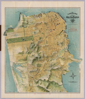
Full Title
The "Chevalier" Commercial, Pictorial and Tourist Map of San Francisco From Latest U.S. Gov. and Official Surveys. Designed-Engraved And Copyrighted By Aug. Chevalier, Lithographer Publisher, 507 Mission St. San Francisco ... The Exposition City 1915. Copyrighted 1912 By Aug. Chevalier ... (on verso) Untitled index to the street, parks, Public Schools ... of San Francisco.
Publisher
August Chevalier
Author
Chevalier, August
Full Title
(Index Page to) Untitled index to the Street, parks, Public Schools ... of San Francisco. (on verso) The "Chevalier" Commercial, Pictorial and Tourist Map of San Francisco From Latest U.S. Gov. and Official Surveys. Designed-Engraved And Copyrighted By Aug. Chevalier, Lithographer Publisher, 507 Mission St. San Francisco ... The Exposition City 1915. Copyrighted 1912 By Aug. Chevalier ...
Publisher
August Chevalier
Author
Chevalier, August
Full Title
The "Chevalier" Commercial, Pictorial and Tourist Map of San Francisco From Latest U.S. Gov. and Official Surveys. Designed-Engraved And Copyrighted By Aug. Chevalier, Lithographer Publisher, San Francisco ... copyrighted 1911 ...
Publisher
Aug. Chevalier
Author
Chevalier, August
Full Title
(Covers to) The commercial, pictorial and tourist map of San Francisco. Copyrighted by Aug. Chevalier, Publisher, 331 Kearny Street. 1st edition 1904.
Publisher
Aug. Chevalier
Author
Chevalier, August
Full Title
(Title Page to) The commercial, pictorial and tourist map of San Francisco. Copyrighted by Aug. Chevalier, Publisher, 331 Kearny Street. 1st edition 1904.
Publisher
Aug. Chevalier
Author
Chevalier, August
Full Title
The commercial, pictorial and tourist map of San Francisco, in colors and illustrated with litho-engraved pictures of all public buildings, parks, monuments, and recommended business houses, etc. Designed, engraved & copyrighted by Aug. Chevalier. Copyrighted 15th Dec. 1903 by Aug. Chevalier. 1st edition, 1904, August. Galloway Litho Co., S.F.
Publisher
Aug. Chevalier
Author
[United Air Lines, White, Ruth Taylor]
Full Title
San Francisco - Reno (upper map). Los Angeles - Boulder Dam (lower map).
Publisher
United Air Lines
Author
Cormack, Robert
Full Title
Mother Lode map : incorporating mother lodes of California and Nevada, scenes of the "Romantic days of Gold". Cartographer: Robert Cormack. Published by Mother Lode Enterprises.
Publisher
Mother Lode Enterprise
Author
Lindgren, Jolly
Full Title
A hysterical map of the Mother Lode : Where California was born, and hell was raised. Drawn in broken English by Jolly Lindgren. (Copyright) Lindgren Brothers- Spokane.
Publisher
Lindgren Brothers
Author
White, Ruth Taylor
Full Title
Wine Map of California. Published by the Wine Advisory Board, San Francisco. Limned by Ruth Taylor (White).
Publisher
Wine Advisory Board
Author
Schmidt Litho. Co.
Full Title
Pictorial Map of Fresno County and Mid-California's Garden of the Sun. Schmidt Litho. Co. Fresno & S.F. (on verso: cover title and) Automobile Road Map of Fresno County, Yosemite Valley, Huntington Lake, General Grant National Park, Sequoia National Park. Map of Fresno County : Showing principal automobile roads. Routes and Map Bureau , California State Automobile Association. 1678 Van Ness Ave. San Francisco. Schmidt Litho. Co. Fresno & S.F. Published by Fresno County Chamber of Commerce. Fresno, California.
Publisher
Fresno County Chamber of Commerce
Author
Mora, Jo (1876-1947)
Full Title
California. This whimsical Carte of Topographic and Historic intention... A devoted adopted son made it. Jo Mora. Copyrighted MCMXXVII by A.M. Robertson, California Publisher Since 1870. San Francisco.
Publisher
A.M. Robertson
Author
Mora, Jo (1876-1947)
Full Title
(Covers to) Yosemite. (Drawn by) Jo Mora. Copyright 1931. The Jo Mora Maps, Carmel California.
Publisher
The Jo Mora Maps
Author
Mora, Jo (1876-1947)
Full Title
Yosemite. (Drawn by) Jo Mora. Copyright 1931. The Jo Mora Maps, Carmel California.
Publisher
The Jo Mora Maps
Author
[Bank of America, California State Fair]
Full Title
The Mother Lode of California. (on verso) '49ers guide to the Mother Lode, Mariposa to Downieville : with map ; profusely illustrated. A souvenir of the California State Fair, with complements of Bank of America National Trust and Savings Association. copyright 1949, bank of America Nt & SA. Photographs from Otheto Weston's Mother Lode Album, Stanford University Press.
Publisher
Bank of America National Trust and Savings Association
Author
[Witta, Jr. Fred, Golden Chain Council of the Mother Lode.]
Full Title
(Covers to) California's Golden Chain : the Mother Load Highway (State Highway 49). Ledger Press, Jackson. (on verso map) California's Golden Chain : the Mother Lode. Designed by Fred Witta, Jr. Amador County. Art work by Pope Studio, Sacramento. (printed by) Sacramento Lithograph Co. Copyright.
Publisher
[Ledger Press, Sacramento Lithograph Co.]
Author
[Witta, Jr. Fred, Golden Chain Council of the Mother Lode.]
Full Title
(Text page to) California's Golden Chain : the Mother Load Highway (State Highway 49). Ledger Press, Jackson. (on verso map) California's Golden Chain : the Mother Lode. Designed by Fred Witta, Jr. Amador County. Art work by Pope Studio, Sacramento. (printed by) Sacramento Lithograph Co. Copyright.
Publisher
[Ledger Press, Sacramento Lithograph Co.]
Author
[Witta, Jr. Fred, Golden Chain Council of the Mother Lode.]
Full Title
California's Golden Chain : the Mother Lode. Designed by Fred Witta, Jr. Amador County. Art work by Pope Studio, Sacramento. (printed by) Sacramento Lithograph Co. Copyright. (on verso cover title) California's Golden Chain : the Mother Load Highway (State Highway 49). Ledger Press, Jackson.
Publisher
[Ledger Press, Sacramento Lithograph Co.]
Author
Sheets, Millard
Full Title
The Panorama Today in Northern California its resources activities and opportunities. Published on its 100th. Anniversary by American Trust Company, San Francisco. Millard Sheets. Lithogravure in U.S.A.
Publisher
American Trust Company
Author
Sheets, Millard
Full Title
The Pageant of History in Northern California its colorful and adventurous beginnings. Published on its 100th. Anniversary by American Trust Company, San Francisco. Millard Sheets. Lithogravure in U.S.A.
Publisher
American Trust Company
Author
Rude, Klengston
Full Title
Pano-view map : California, Nevada. Progressive. Historical. Spectacular. Recreational. Kleng Rude. C(opyright) 1962 Kleng Rude Studios, Long Beach.
Publisher
Kleng Rude Studios
Author
[Butler, Lowell, Newbro, William H., Robinson, William W.]
Full Title
(Covers to) A map of the missions, presidios, pueblos, and some of the more interesting ranchos of Spanish California : together with the routes of the principal land explorations therein. Published by Westways. (copyright) 1956 by the Automobile Club of Southern California. (on opposite page) A note of Explanation (by) Phil Townsend Hanna
Publisher
[Westways, Automobile Club of Southern California]
Author
[Butler, Lowell, Newbro, William H., Robinson, William W.]
Full Title
A map of the missions, presidios, pueblos, and some of the more interesting ranchos of Spanish California : together with the routes of the principal land explorations therein. Compiled by W. W. Robinson and William H. Newbro, Jr. ; edited by Phil Townsend Hanna ; cartography by Lowell Butler ; Drawings by Ken Sawyer ; color by Harry O. Diamond ; (on lower margin) December 1956, Westways, Vol. 48, No. 12. (insets) San Francisco -Monterey Area ; Los Angeles and vicinity Area.
Publisher
[Westways, Automobile Club of Southern California]
Author
[Butler, Lowell, Webb, William, Hanna, Phil Townsend, 1896-1957]
Full Title
(Covers to) Outdoor play places of California : a cartographic map of some of the outstanding recreational areas of the Golden State : Published by Westways ; Copyright 1954 by the Automobile Club of Southern California. (on opposite page) A note of Explanation (by) Phil Townsend Hanna.
Publisher
[Westways, Automobile Club of Southern California]
Author
[Butler, Lowell, Webb, William, Hanna, Phil Townsend, 1896-1957]
Full Title
Outdoor play places of California : a cartographic map of some of the outstanding recreational areas of the Golden State : designed by Lowell Butler with descriptive notes by William Webb and Phil Townsed Hanna. Copyright 1954 by the Automobile Club of Southern California. Drawings by Ken Sawyer. Color by Harry O. Diamond. (on lower margin) December 1954, Westways, Vol. 46, No. 12.
Publisher
[Westways, Automobile Club of Southern California]
Author
[Butler, Lowell, Webb, William, Hanna, Phil Townsend, 1896-1957]
Full Title
(Covers to) A Map of the Marked Historical Sites of California : Compiled from the official registrations of the California State Department of Natural Resources: Published by Westways ; Copyright 1952 by the Automobile Club of Southern California. (on opposite page) A note of Explanation (by) Phil Townsend Hanna.
Publisher
[Westways, Automobile Club of Southern California]
Author
[Butler, Lowell, Webb, William, Hanna, Phil Townsend, 1896-1957]
Full Title
(Text Page to) A Map of the Marked Historical Sites of California : Compiled from the official registrations of the California State Department of Natural Resources : By Phil Townsend Hanna and William Webb : Cartography By Lowell Butler. Copyright 1952 by the Automobile Club of Southern California. Drawing by Gordon Brusstar. Color by Harry Diamond. (on lower margin) December 1952, Westways, Vol. 44, No. 12.
Publisher
[Westways, Automobile Club of Southern California]
Author
[Butler, Lowell, Webb, William, Hanna, Phil Townsend, 1896-1957]
Full Title
A Map of the Marked Historical Sites of California : Compiled from the official registrations of the California State Department of Natural Resources : By Phil Townsend Hanna and William Webb : Cartography By Lowell Butler. Copyright 1952 by the Automobile Club of Southern California. Drawing by Gordon Brusstar. Color by Harry Diamond. (on lower margin) December 1952, Westways, Vol. 44, No. 12.
Publisher
[Westways, Automobile Club of Southern California]
Author
F.A.P. Fine additional Printers
Full Title
Silicon Valley. 1991. F.A.P. Fine Additional Printers. Mountain View.
Publisher
F.A.P.
Author
[Taylor, Frank J., White, Ruth Taylor]
Full Title
California.
Publisher
Little, Brown, and Company
Author
Forest Lawn Memorial-Park Association
Full Title
(Covers to) Pictorial map of Forest Lawn Memorial-Park, Glendale, California. Copyrighted 1945 by Forest Lawn Memorial-Park Assn., Inc. (on verso) Pictorial map of Forest Lawn Memorial - Park, showing the location of interment sections, buildings and art treasures.
Publisher
Forest Lawn Assn., Inc.
Author
Forest Lawn Memorial-Park Association
Full Title
(Text Page to) Pictorial map of Forest Lawn Memorial-Park, Glendale, California. Copyrighted 1945 by Forest Lawn Memorial-Park Assn., Inc. (on verso) Pictorial map of Forest Lawn Memorial - Park, showing the location of interment sections, buildings and art treasures.
Publisher
Forest Lawn Assn., Inc.
Author
Forest Lawn Memorial-Park Association
Full Title
Pictorial map of Forest Lawn Memorial - Park, showing the location of interment sections, buildings and art treasures. (on verso) Pictorial map of Forest Lawn Memorial-Park, Glendale, California. Copyrighted 1945 by Forest Lawn Memorial-Park Assn., Inc.
Publisher
Forest Lawn Assn., Inc.
1-35 of 35
|