Browse All

1936 Alger County, Michigan. Guide Book Alger County. |

1936 Marquette County, Michigan. Guide Book Marquette County. |

1936 Baraga County, Michigan. Guide Book Baraga County. |

1936 Isle Royale, Michigan. Guide Book Isle Royale. |

1936 Houghton County, Michigan. Guide Book Houghton County. |

1938 Albert Richard Football map Separate Map Albert Richard Football map. Copyright 1 … |

1847 Pictorial View of the World. Broadside Pictorial View of the World. Entered...1 … |

1852 The World At One View. Broadside The World At One View. Entered...1847, b … |

1854 World At One View. Broadside World At One View. Ensign, Bridgman & Fa … |

1837 Animals - World. School Atlas Chart of the principal animals of the Wo … |

1836 Picture of nations. Historical Atlas Picture of nations or perspective sketch … |

1904 Cover: San Francisco. [Guide Book, Pocket Map] (Covers to) The commercial, pictorial an … |

1904 Title Page: San Francisco. [Guide Book, Pocket Map] (Title Page to) The commercial, pictoria … |

1904 San Francisco. [Guide Book, Pocket Map] The commercial, pictorial and tourist ma … |

1942 Dated events, World War map, by Stanley … Separate Map Dated events, World War map, by Stanley … |

1958 Canada,Alaska, and Greenland (Continues) … World Atlas Canada,Alaska, and Greenland. (Pictorial … |

1958 South America (Continues) Pictorial map World Atlas South America. (Pictorial map). |

1958 Pictorial map of Europe World Atlas (Pictorial map of Europe). (with inset) |

1958 Pictorial map of Africa World Atlas (Pictorial map of Africa). |

1958 Pictorial map of Asia World Atlas (Pictorial map of Asia) |

1958 Pictorial map of Australasia World Atlas (Pictorial map of) Australasia. (Copyrig … |

1876 Composite (Pictorial St. Louis) View (Pictorial St. Louis) Composite (By C.N. … |

1945 American Airlines system map. Pocket Map American Airlines system map. Route of t … |

1945 Verso: American Airlines system map. Pocket Map (Verso of) American Airlines system map. … |
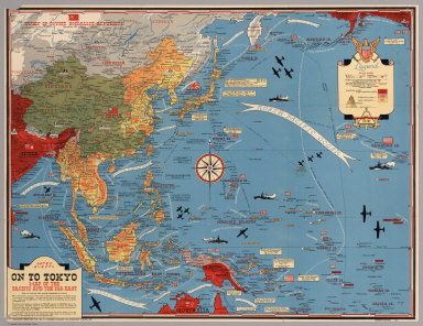
1944 Dated Events. On To Tokyo. Map of the Pa … Separate Map Dated Events. On To Tokyo. Map of the Pa … |

1938 Mississippi the magnolia state Separate Map Mississippi the magnolia state. Copyrigh … |
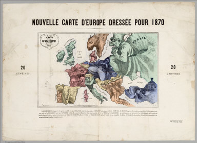
1870 Carte drolatique d'Europe pour 1870 Separate Map Carte drolatique d'Europe pour 1870 ; dr … |
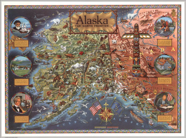
1959 Alaska: Far North frontier Separate Map Alaska: Far North frontier. Published an … |

1935 Nebraska. National Atlas Nebraska. |

1935 Nevada. National Atlas Nevada. |

1935 New Hampshire. National Atlas New Hampshire. |

1935 New Jersey. National Atlas New Jersey. |

1935 New Mexico. National Atlas New Mexico. |

1935 New York. National Atlas New York. |

1935 North Carolina. National Atlas North Carolina. |

1935 North Dakota. National Atlas North Dakota. |

1935 Ohio. National Atlas Ohio. |

1935 Oklahoma. National Atlas Oklahoma. |

1935 Oregon. National Atlas Oregon. |

1935 Panama Canal Zone, and Porto (Puerto) Ri … National Atlas Panama Canal Zone, and Porto (Puerto) Ri … |

1935 Pennsylvania. National Atlas Pennsylvania. |

1935 Philippine Islands. National Atlas Philippine Islands. |

1935 Rhode Island. National Atlas Rhode Island. |

1935 South Carolina. National Atlas South Carolina. |

1935 South Dakota. National Atlas South Dakota. |

1935 Tennessee. National Atlas Tennessee. |

1935 Texas. National Atlas Texas. |

1935 Utah. National Atlas Utah. |

1935 Vermont. National Atlas Vermont. |

1935 Virginia. National Atlas Virginia. |