Who What Where WhenREMOVEWHAT |
REFINE
Browse All : Pocket Map from 1843
1-8 of 8
Author
Tanner, Henry S.
Full Title
New Hampshire & Vermont: By H.S. Tanner. Published by H.S. Tanner Philadelphia. Tanner & Disturnell, 124 Broadway, New York. Entered ... 1840, by H.S. Tannerr ... Pennsylvania. Engraved by J. & W.W. Warr. (above the neat line) Tanner's Universal Atlas.
Publisher
[H.S. Tanner;, Tanner & Disturnell]
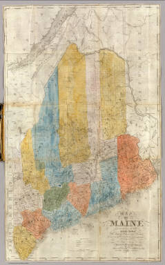
Author
[Finley, Anthony, Tanner, T.R.]
Full Title
Maine.
Publisher
No publisher
Author
Anson, W.
Full Title
Map Of Maine Constructed from the most Correct Surveys With Sectional Distances and Elevations or Level, of the St. Croix River from Calais Bridge. Deduced from the States Survey, Made by W. Anson, Civil Engineer, In 1836. Engraved & Published by by S.H. Colesworthy, Portland. 1843. Revised Edition.
Publisher
S.H. Colesworthy
Author
Tanner, Henry S.
Full Title
(Covers to) New Hampshire & Vermont: By H.S. Tanner. Published by H.S. Tanner Philadelphia. Tanner & Disturnell, 124 Broadway, New York. Entered ... 1840, by H.S. Tannerr ... Pennsylvania. Engraved by J. & W.W. Warr. (above the neat line) Tanner's Universal Atlas.
Publisher
[H.S. Tanner;, Tanner & Disturnell]
Author
[Mitchell, Samuel Augustus, Young, James H.]
Full Title
Mitchell's Travellers Guide Through The United States. A Map Of The Roads, Distances, Steam Boat & Canal Routes &c. By J.H. Young. Philadelphia. Published by S. Augustus Mitchell. 1843. Engraved On Steel By J.H. Young And D. Haines. Entered ... 1834 by S. Augustus Mitchell ... Pennsylvania. (with 8 inset maps).
Publisher
Thomas, Cowperthwait & Co.
Author
Phelps & Ensign
Full Title
Phelps & Ensign's Traveller's Guide Through the United States ... Illustrated By A New And Accurate Map Of The United States. New York: Phelps & Ensign, No. 7 Bowery. 1843. Entered .. 1838, by Phelps & Ensign .. New York. (with) Phelps & Ensign's Travellers' Guide, and Map of the United States ... New York, Published by T & E.H. Ensign, 1843. Engraved on Steel by J.Wells, Brooklyn L.I. Entered ... 1837 by Phelps & Squire ... New York. (with 16 inset maps).
Publisher
Phelps & Ensign
Author
[Finley, Anthony, Tanner, T.R.]
Full Title
(Covers to) Maine.
Publisher
No publisher
Author
Anson, W.
Full Title
(Covers to) Map Of Maine Constructed from the most Correct Surveys With Sectional Distances and Elevations or Level, of the St. Croix River from Calais Bridge. Deduced from the States Survey, Made by W. Anson, Civil Engineer, In 1836. Engraved & Published by by S.H. Colesworthy, Portland. 1843. Revised Edition.
Publisher
S.H. Colesworthy
1-8 of 8
|