Who What Where WhenREMOVE |
REFINE
Browse All : Pocket Map from 1867
1-29 of 29
Author
[Creuzbaur, Robert, De Cordova, Jacob, G.W. & C.B. Colton & Co.]
Full Title
J. De Cordova's Map Of The State Of Texas Compiled from the records of the General Land Office of the State by Robert Creuzbaur, Austin, 1867 New Edition, revised and corrected to date. Entered ... on the 28th day of July 1848 by J. De Cordova ... Texas. (inset) Plan Showing Lines Of Communication Between Western Texas And The Pacific Coast.
Publisher
[G.W. & C.B. Colton, Robert Creuzbaur]
Author
[Colton, G. W. & C. B., Ream, Robert L.]
Full Title
New Sectional Map Of Kansas Compiled from the U.S. Surveys By Robt. L. Ream, Late Principal Clerk in the Surveyor Generals Office at Leavenworth, Published By G.W. And C.B. Colton, 172 William St. New York. 1867. Entered ... 1865 by G. Woolworth Colton ... New York. (inset) Routes From Chicago And St. Louis To Kansas.
Publisher
G.W. & C.B. Colton
Author
[Colton, G. W. & C. B., Ream, Robert L.]
Full Title
(Composite of) New Sectional Map Of Kansas Compiled from the U.S. Surveys By Robt. L. Ream, Late Principal Clerk in the Surveyor Generals Office at Leavenworth, Published By G.W. And C.B. Colton, 172 William St. New York. 1867. Entered ... 1865 by G. Woolworth Colton ... New York. (inset) Routes From Chicago And St. Louis To Kansas.
Publisher
G.W. & C.B. Colton
Author
[Colton, G. W. & C. B., Messinger, John, Peck, J. M., Mathewson, A.J.]
Full Title
Colton's Sectional Map Of the State of Illinois. Compiled From The United States Surveys. Also exhibiting the Internal Improvements, distances between Towns, Villages & Post Offices, the outlines of Prairies, Woodlands, Marshes & the lands donated to the State by the Gen. Govt. for the purpose of Internal Improvements. By J.M. Peck, John Messinger, And A.J. Mathewson. Published by G.W. And C.B. Colton, & Co., No. 172 William St., New York. 1867. Entered ... 1836 by J.H. Colton & Co ... New York. (inset) The City Of Chicago Illinois. (inset) The City Of St. Louis Missouri.
Publisher
G.W. & C.B. Colton & Co.
Author
Colton, G.W. & C.B.
Full Title
Map showing the Line of The New Haven, Middletown And Boston Railroad and its connections. Published by G.W. And C.B. Colton, & Co. 172 William St. New York. 1867. Entered ... 1867 by G.W. & C.B. Colton & Co ... New York.
Publisher
G.W. & C.B. Colton.
Author
[Gunn, O.B., Mitchell, D.T.]
Full Title
Gunn & Mitchell's New Map Of Kansas And The Gold Mines Embracing all the Public Surveys up to 1866 Principal Meridian. Compiled from the Original Field Notes by O.B. Gunn & D.T. Mitchell. Lawrence, Kan. 1867 ... January 1st, 1867. H.S. Sleeper, Surveyor General Kansas and Nebraska. Entered ... 1862 by Gunn & Mitchell ... Kansas. Krebs & Bro. lith. Pittsburgh, Pa.
Publisher
O.B. Gunn & D.T. Mitchell
Author
Colton, G.W. & C.B.
Full Title
Colton's Railroad & Township Map of the State of Ohio. Published By G.W. & C.B. Colton, No. 172 William St. New York. 1867. Entered ... 1851 by J.H. Colton ... New York.
Publisher
G.W. & C.B. Colton
Author
Watson, Gaylord
Full Title
The American Republic and rail-road map of the United States, British Provinces, West-Indies, Mexico and Central America. Compiled from the latest official sources. Published by Gaylord Watson, 16 Beekman Street, New York. 1867. Entered ... 1866, by Gaylord Watson ... New York. Engraved by Fisk & Russell, N. York.
Publisher
Gaylord Watson
Author
[Frey, A.C., Nell, Louis]
Full Title
Frey & Nell's New England. Railroad, Topographical & Township Map of the States of Connecticut, Rhode Island, Massachusetts, Vermont, New Hampshire and Maine. New York, H.H. Lloyd & Co. Publishers, 21 John St. Concord, N.H. D.L. Guernsey & Co. 1867 ... American Photo-Lithographic Co. N. York. Osborne's Process. Entered ... 1867, by Frey & Nell ... New York. (untitled inset of Maine).
Publisher
[H.H. Lloyd & Co., D.L. Guernsey & Co.]
Author
Lloyd, H.H.
Full Title
40 Miles Around New York. Published by H.H. Lloyd & Co. 21 John St. New York 1867. Entered ... 1866, by H.H. Lloyd & Co. ... New York. (On Verso) H.H. Lloyd's New Map Of The Great Metropolis, Including The Cities Of New York, Brooklyn, Jersey City, Hoboken, &c. Published By H.H. Lloyd & Co. ... 1867. Eng'd by Fisk & Russell, 43 Chatham St. N.Y.
Publisher
H.H. Lloyd & Co.
Author
Lloyd, H.H.
Full Title
H.H. Lloyd's New Map Of The Great Metropolis, Including The Cities Of New York, Brooklyn, Jersey City, Hoboken, &c. Published By H.H. Lloyd & Co. ... 1867. Eng'd by Fisk & Russell, 43 Chatham St. N.Y. (One Verso) 40 Miles Around New York. Published by H.H. Lloyd & Co. 21 John St. New York 1867. Entered ... 1866, by H.H. Lloyd & Co. ... New York.
Publisher
H.H. Lloyd & Co.
Author
Debray, V.
Full Title
Carta General De La Republica Mexicana Formada Y Corregida Con presencia de los ultimos datos y el auxilio de las autoridades mas competentes. Mexico, Impa. Litoga. De Debray, Editor. Esquina del Callejon del Espiritu Santo y Coliseo Viejo. 1867. (inset) Croquis de los Caminos de Mexico a Vera-Cruz. (with 3 additional inset maps and 4 profiles).
Publisher
Debray, Editor
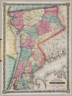
Author
Colton, G.W. & C.B.
Full Title
Colton's Map Of The County Of Westchester. Drawn, Engraved and Published by G.W. & C.B. Colton & Co. 172 William St. New York. 1867. Entered ... 1867 by G.W. & C.B Colton & Co. ... New York.
Publisher
G.W. & C.B Colton & Co.
Author
[Colton, G. W. & C. B., Swann, John S.]
Full Title
Title Map of the Coal Field Of The Great Kanawha Valley West Virginia, United States of America. By John S. Swann, Attorney at Law, Charleston, Kanawha County W. Va. Engraved, Printed, And Manufactured By G.W. & C.B. Colton & Co. No. 172 Williams St New York. Price of Map $10.00 To Be Procured Of Thomas L. Broun ... and John S. Swann ... Entered ... 1867, by John S. Swann ... Charleston, West Virginia. (inset) West Virginia Showing the rail and water communication Between The Great Kanawha District And Pittsburgh & Cincinnati.
Publisher
G.W. & C.B. Colton
Author
[Creuzbaur, Robert, De Cordova, Jacob, G.W. & C.B. Colton & Co.]
Full Title
(Covers to) J. De Cordova's Map Of The State Of Texas Compiled from the records of the General Land Office of the State by Robert Creuzbaur, Austin, 1867 New Edition, revised and corrected to date. Entered ... on the 28th day of July 1848 by J. De Cordova ... Texas. (inset) Plan Showing Lines Of Communication Between Western Texas And The Pacific Coast. (G.W. & C.B. Colton & Co.)
Publisher
[G.W. & C.B. Colton, Robert Creuzbaur]
Author
[Colton, G. W. & C. B., Ream, Robert L.]
Full Title
(Covers to) New Sectional Map Of Kansas Compiled from the U.S. Surveys By Robt. L. Ream, Late Principal Clerk in the Surveyor Generals Office at Leavenworth, Published By G.W. And C.B. Colton, 172 William St. New York. 1867. Entered ... 1865 by G. Woolworth Colton ... New York. (inset) Routes From Chicago And St. Louis To Kansas.
Publisher
G.W. & C.B. Colton
Author
[Colton, G. W. & C. B., Messinger, John, Peck, J. M., Mathewson, A.J.]
Full Title
(Covers to) Colton's Sectional Map Of the State of Illinois. Compiled From The United States Surveys. Also exhibiting the Internal Improvements, distances between Towns, Villages & Post Offices, the outlines of Prairies, Woodlands, Marshes & the lands donated to the State by the Gen. Govt. for the purpose of Internal Improvements. By J.M. Peck, John Messinger, And A.J. Mathewson. Published by G.W. And C.B. Colton, & Co., No. 172 William St., New York. 1867. Entered ... 1836 by J.H. Colton & Co ... New York. (inset) The City Of Chicago Illinois. (inset) The City Of St. Louis Missouri.
Publisher
G.W. & C.B. Colton & Co.
Author
Colton, G.W. & C.B.
Full Title
(Covers to) Map showing the Line of The New Haven, Middletown And Boston Railroad and its connections. Published by G.W. And C.B. Colton, & Co. 172 William St. New York. 1867. Entered ... 1867 by G.W. & C.B. Colton & Co ... New York.
Publisher
G.W. & C.B. Colton.
Author
Colton, G.W. & C.B.
Full Title
(Covers to) Colton's Railroad & Township Map of the State of Ohio. Published By G.W. & C.B. Colton, No. 172 William St. New York. 1867. Entered ... 1851 by J.H. Colton ... New York.
Publisher
G.W. & C.B. Colton
Author
Watson, Gaylord
Full Title
(Covers to) The American Republic and rail-road map of the United States, British Provinces, West-Indies, Mexico and Central America. Compiled from the latest official sources. Published by Gaylord Watson, 16 Beekman Street, New York. 1867. Entered ... 1866, by Gaylord Watson ... New York. Engraved by Fisk & Russell, N. York.
Publisher
Gaylord Watson
Author
Watson, Gaylord
Full Title
(Inside Covers to) The American Republic and rail-road map of the United States, British Provinces, West-Indies, Mexico and Central America. Compiled from the latest official sources. Published by Gaylord Watson, 16 Beekman Street, New York. 1867. Entered ... 1866, by Gaylord Watson ... New York. Engraved by Fisk & Russell, N. York.
Publisher
Gaylord Watson
Author
[Frey, A.C., Nell, Louis]
Full Title
(Covers to) Frey & Nell's New England. Railroad, Topographical & Township Map of the States of Connecticut, Rhode Island, Massachusetts, Vermont, New Hampshire and Maine. New York, H.H. Lloyd & Co. Publishers, 21 John St. Concord, N.H. D.L. Guernsey & Co. 1867 ... American Photo-Lithographic Co. N. York. Osborne's Process. Entered ... 1867, by Frey & Nell ... New York. (untitled inset of Maine).
Publisher
[D.L. Guernsey & Co., H.H. Lloyd & Co.]
Author
Lloyd, H.H.
Full Title
(Covers to) 40 Miles Around New York. Published by H.H. Lloyd & Co. 21 John St. New York 1867. Entered ... 1866, by H.H. Lloyd & Co. ... New York. (On Verso) H.H. Lloyd's New Map Of The Great Metropolis, Including The Cities Of New York, Brooklyn, Jersey City, Hoboken, &c. Published By H.H. Lloyd & Co. ... 1867. Eng'd by Fisk & Russell, 43 Chatham St. N.Y.
Publisher
H.H. Lloyd & Co.
Author
Blanchard, Rufus
Full Title
Blanchard's Map Of Iowa And Nebraska Showing The Counties Towns & Rail Roads. Published by Rufus Blanchard, Chicago. 1867. Lith Chas Shober, Chicago.
Publisher
Rufus Blanchard
Author
Debray, V.
Full Title
(Covers to) Carta General De La Republica Mexicana Formada Y Corregida Con presencia de los ultimos datos y el auxilio de las autoridades mas competentes. Mexico, Impa. Litoga. De Debray, Editor. Esquina del Callejon del Espiritu Santo y Coliseo Viejo. 1867. (inset) Croquis de los Caminos de Mexico a Vera-Cruz. (with 3 additional inset maps and 4 profiles).
Publisher
Debray, Editor
Author
Blanchard, Rufus
Full Title
Blanchard's Map Of Minnesota And Dakota Showing The Counties, Towns & Rail Roads. 1867. Published by Rufus Blanchard Chicago, Ill.
Publisher
Blanchard & Cram.
Author
Colton, G.W. & C.B.
Full Title
(Covers to) Colton's Map Of The County Of Westchester. Drawn, Engraved and Published by G.W. & C.B. Colton & Co. 172 William St. New York. 1867. Entered ... 1867 by G.W. & C.B Colton & Co. ... New York.
Publisher
G.W. & C.B Colton & Co.
Author
[Gunn, O.B., Mitchell, D.T.]
Full Title
(Covers to) Gunn & Mitchell's New Map Of Kansas And The Gold Mines Embracing all the Public Surveys up to 1866 Principal Meridian. Compiled from the Original Field Notes by O.B. Gunn & D.T. Mitchell. Lawrence, Kan. 1867 ... January 1st, 1867. H.S. Sleeper, Surveyor General Kansas and Nebraska. Entered ... 1862 by Gunn & Mitchell ... Kansas. Krebs & Bro. lith. Pittsburgh, Pa.
Publisher
O.B. Gunn & D.T. Mitchell
Author
[Colton, G. W. & C. B., Swann, John S.]
Full Title
(Covers to) Title Map of the Coal Field Of The Great Kanawha Valley West Virginia, United States of America. By John S. Swann, Attorney at Law, Charleston, Kanawha County W. Va. Engraved, Printed, And Manufactured By G.W. & C.B. Colton & Co. No. 172 Williams St New York. Price of Map $10.00 To Be Procured Of Thomas L. Broun ... and John S. Swann ... Entered ... 1867, by John S. Swann ... Charleston, West Virginia. (inset) West Virginia Showing the rail and water communication Between The Great Kanawha District And Pittsburgh & Cincinnati.
Publisher
G.W. & C.B. Colton
1-29 of 29
|