Who What Where WhenREMOVE |
Author
[Bielawski, C., Hoffman, Hoffmann, J.D., Poett, A.]
Full Title
Topographical And Railroad Map of the Central Part of the State of California, and Part of the State Of Nevada. 1865. Compiled from Railroad Surveys, U.S. Public Land Surveys, U.S. Coast Surveys, California State Geological Survey (Prof. J.D. Whitney), and from reliable private Surveys, and Published by C. Bielawski, J.D. Hoffmann & A. Poett, Civil Engineers & Survrs. Britton & Co. Lith: San Francisco. Entered ... 1865 by J.D. Hoffmann & A. Poett ... California.
Publisher
Britton & Co. Lith.
Author
[Frey, A.C., Nell, Louis]
Full Title
Topographical Railroad & County Map Of The States Of California And Nevada Compiled from the latest explorations and other official information by L. Nell, N.Y. Published by A.C. Frey & Co 204 Fulton St. New York. General Agents for California A. Roman & Co. 417 & 419 Montgomery St. San Francisco. Ferd. Mayer & Co. Lithographers, 96 Fulton St. N.Y. Entered ... 1868 by Frey & Nell ... New York. (inset) Map of the City of San Francisco, California. (inset) Map Of The Great National Pacific Railroads.
Publisher
A.C. Frey & Co.
Author
Hutawa, Julius
Full Title
Map Of Mexico & California. Compiled from the latest authorities. By Juls. Hutawa. Lithr. Second St. 45 St. Louis, Mo. 2nd Edition. 1863. (inset) Vicinity of Mexico.
Publisher
J. Hutawa
Author
Goodwin, F.A.
Full Title
Map Of California And The Adjacent Country. Compiled by F. Goodwin From the best Authors and actual Observation. Entered ... 1855 by F. Goodwin ... New York. Lith. of Geo. E. Leefe, 223 Fulton St. N.Y. (with 8 page description) A Brief Description of California, From The Time of Its First Occupation by the United States and Subsequent Growth ... Accompanied by a Map of California and adjacent Country.
Publisher
Geo. E. Leefe
Author
Denny, Edward & Co.
Full Title
Denny's Pocket Map Of Fresno County California. Compiled From Latest Official And Private Data. Edward Denny & Co. Map Publishers 1132 Shotwell St., San Francisco. Copyright 1911 By Edward Denny & Co.
Publisher
Edward Denny & Co.
Author
Weber, C.F.
Full Title
Weber's Township And County Map Of California And Nevada Compiled From The Latest Official Data. Published By C.F. Weber & Co. San Francisco And Los Angeles California. Copyright, 1910, By C.F. Weber & Co. Photo-Lith. Britton & Rey.
Publisher
C.F. Weber & Co.
Author
Denny, Edward & Co.
Full Title
Denny's Pocket Map Of Ventura County, California. Compiled From Latest Official And Private Data By Edward Denny & Co. Map Publishers 1132 Shotwell St., San Francisco. Copyright 1913 By Edward Denny & Co.
Publisher
Edward Denny & Co.
Author
Willson & Co.
Full Title
Willson & Co.'s Indexed Sectional Map Of Southern California. Compiled And Published By Willson & Co., Map Publishers, 213 Powell St. San Francisco, Cal. Copyrighted 1895. Galloway Litho.Co. S.F.
Publisher
Willson & Co.
Author
[Bancroft, H.H., Knight, W.H.]
Full Title
Bancroft's Map Of Central California. Compiled by Wm. Henry Knight. Published By H.H. Bancroft & Co. 609 Montgomery St. San Francisco 1869. Entered ... 1868, by H.H. Bancroft & Co. ... California. J. & R. McLellan N.Y. The Map Of Central California Is Published In Pocket Form, Price 50 Cents.
Publisher
H.H. Bancroft & Co.
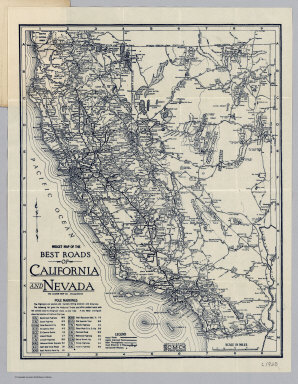
Author
Clason Map Company
Full Title
Midget Map Of The Best Roads Of California And Nevada. The Clason Map Co. Chicago-Denver. Copyrighted The C.M. Co. All Rights Reserved.
Publisher
Clason Map Company
Author
Pacific Southwest Trust & Savings Bank
Full Title
Midget Map of Santa Ana California. Issued by Santa Ana Branch Pacific-Southwest Trust & Savings Bank, 102 E. Fourth St. Santa Ana, Calif. Copyrighted by Franklin P. Borgnis, L.A. (on verso) Motor And Relief Map Of Southern California. Issued by Santa Ana Branch Pacific-Southwest Trust & Savings Bank Identical In Ownership With The First National Bank of Los Angeles and the First Securities Company. This Map copyrighted, 1923, by Pacific-Southwest Trust & Savings Bank.
Publisher
Pacific Southwest Trust & Savings Bank
Author
Pacific Southwest Trust & Savings Bank
Full Title
Motor And Relief Map Of Southern California. Issued by Santa Ana Branch Pacific-Southwest Trust & Savings Bank Identical In Ownership With The First National Bank of Los Angeles and the First Securities Company. This Map copyrighted, 1923, by Pacific-Southwest Trust & Savings Bank. (on verso) Midget Map of Santa Ana California. Issued by Santa Ana Branch Pacific-Southwest Trust & Savings Bank, 102 E. Fourth St. Santa Ana, Calif. Copyrighted by Franklin P. Borgnis, L.A.
Publisher
Pacific Southwest Trust & Savings Bank
Author
Pacific Southwest Trust & Savings Bank
Full Title
Midget Map of San Luis Obispo California. Issued by San Luis Obispo Branch Pacific-Southwest Trust & Savings Bank, Chorro and Higuera Streets, San Luis Obispo, Calif. Copyrighted by Franklin P. Borgnis, L.A. (on verso) Motor And Relief Map Of The Pacific-Southwest. Issued by San Luis Obispo Branch Pacific-Southwest Trust & Savings Bank Affiliated With The First National Bank of Los Angeles and the First Securities Company ... Copyright 1923 by The First National Bank of Los Angeles all rights reserved.
Publisher
Pacific Southwest Trust & Savings Bank
Author
Pacific Southwest Trust & Savings Bank
Full Title
Motor And Relief Map Of The Pacific-Southwest. Issued by San Luis Obispo Branch Pacific-Southwest Trust & Savings Bank Affiliated With The First National Bank of Los Angeles and the First Securities Company ... Copyright 1923 by The First National Bank of Los Angeles all rights reserved. (on verso) Midget Map of San Luis Obispo California. Issued by San Luis Obispo Branch Pacific-Southwest Trust & Savings Bank, Chorro and Higuera Streets, San Luis Obispo, Calif. Copyrighted by Franklin P. Borgnis, L.A.
Publisher
Pacific Southwest Trust & Savings Bank
Author
National Automobile Club
Full Title
Road Map of California Prepared By The Engineering Dept Of The National Automobile Club. Copyright 1926 National Automobile Club.
Publisher
National Automobile Club
Author
Colton, J. H.
Full Title
California. Published By J.H. Colton, No. 86 Cedar St. New York. 1854. Entered ... 1853, by J.H. Colton ... New York. (inset) City of San Francisco.
Publisher
J. H. Colton.
Author
[Bancroft, H.H., Knight, W.H.]
Full Title
Bancroft's Map Of California, Nevada, Utah And Arizona. Published By H.H. Bancroft, & Compy. Booksellers & Stationers San Francisco Cal. 1864. Entered ... 1863 by H.H. Bancroft & Company ... California.
Publisher
H.H. Bancroft & Company
Author
Punnett Brothers
Full Title
Map Of The State Of California. Compiled And Published By Punnett Bros. 625 Mission St., S.F., Cal. 1897. Copyrighted. B.H.C. Sandy, Sole Agent. 316 Battery St. S.F. (inset) San Joaquin Valley. (inset) Yosemite Valley And Vicinity.
Publisher
Punnett Brothers, and B.H.C. Sandy
Author
[Perris, Fred T., Levet, Benj. F.]
Full Title
Perris' Miners Map Of The Desert Region Of Southern California Embracing The Counties Of San Bernardino, Riverside and Orange, and Portions Of The Adjacent Counties, Showing Mining Districts, Forest Reserves, Indian Reservations, and County Boundaries. Compiled And Drawn In The Office Of The Chief Engineer Of The Southern California Railway, By Benj. F. Levet, From Data Acquired By Fred T. Perris, Chief Engineer, From All Authentic Sources, 1896. Approved By Boards of Supervisors of Los Angeles, San Bernardino, and Riverside Counties. Copyright, 1896, By Fred T. Perris. Assigned To Rand, McNally & Co. Map Publishers, Chicago.
Publisher
Rand, McNally & Co.
Author
The Holden Drug Co.
Full Title
Map Of The City of Stockton, California Copyrighted March 18, 1897. Published By The Holden Drug Co. Corner Main and El Dorado Streets Stockton, California.
Publisher
The Holden Drug Co.
Author
[Bancroft, A.L., Knight, W.H.]
Full Title
Bancroft's Map Of California, Nevada, Utah And Arizona. Published By A.L. Bancroft, & Compy. Booksellers & Stationers San Francisco Cal. 1876. Entered ... by A.L. Bancroft & Company ... Washington, D.C.
Publisher
A.L. Bancroft & Co.
Author
Edwards, R.M.
Full Title
Railroad Map Of The City Of San Francisco, California. Published by R.M. Edwards, Late D.E. Appleton & Co., Publisher & Bookseller, 508 & 510 Montgomery Street, San Francisco.
Publisher
R.M. Edwards
Author
Rand McNally and Company
Full Title
Rand McNally Junior Road Map California and Nevada. Copyright By Rand McNally & Co. Chicago Ill. Made In U.S.A. .. (1926)
Publisher
Rand McNally
Author
McDonald & Williams
Full Title
Miniature Map Of San Francisco. Published By McDonald & Williams 14 Montgomery Street, San Francisco. McDonald & Williams' Clothing House Is at the Point of the Arrow. Copyrighted by McDonald & Williams, 1879. Designed, Engraved and Printed by the Pacific Press Publishing House, 12th and Castro Sts., Oakland; Office 22 Montgomery St., S.F.
Publisher
Pacific Press
Author
Jackson, William A.
Full Title
Map of the Mining District of California by Wm. A. Jackson. Copyright secured. Entered ... 1850 by Theodore A. Mudge ... New York. Lambert & Lane's Litho. No. 69 Wall St. N.Y. (Reprint by Thomas W. Norris, Livermore, Calif. December 25, 1936).
Publisher
T.W. Norris
Author
Gensoul, A.
Full Title
Railroad Map Of The City Of San Francisco California. A. Gensoul Bookseller and Stationer. 511 Montgomery St. San Francisco. Lith. Britton & Co. S.F.
Publisher
A. Gensoul.
Author
Weber, C.F.
Full Title
Weber's Township And County Map Of California And Nevada Compiled From The Latest Official Data. Published By C.F. Weber & Co. San Francisco And Los Angeles California. Copyright, 1904 By C.F. Weber & Co. Mutual L. & L. Co. S.F.
Publisher
C.F. Weber & Co.
Author
Cram, George Franklin
Full Title
Railroad And County Map Of California. Geo. F. Cram, Engraver and Publisher, Chicago. 1890. (inset: untitled map of the San Francisco Bay Area by county).
Publisher
George F. Cram
Author
Tanner, Henry S.
Full Title
Map of California New Mexico Texas &c. Published by H.S. Tanner No. 156 Fulton St. New York 1849.
Publisher
H.S. Tanner
Author
Rand McNally and Company
Full Title
Rand McNally 1926 Detailed Auto Road Map of Los Angeles And Vicinity. (on verso) Rand McNally Junior Road Map California Nevada. Copyright By Rand McNally & Co. Chicago, Ill. Made In U.S.A. (with map) City Of Santa Ana, Orange County, California. 1923 Clyde D. Butler, Lic. Sur. Revised 1925, Nat. H. Neff, City Engineer.
Publisher
Rand McNally and Company
Author
Rand McNally and Company
Full Title
Rand McNally Junior Road Map California Nevada. Copyright By Rand McNally & Co. Chicago, Ill. Made In U.S.A. (with map) City Of Santa Ana, Orange County, California. 1923 Clyde D. Butler, Lic. Sur. Revised 1925, Nat. H. Neff, City Engineer. (on verso) Rand McNally 1926 Detailed Auto Road Map of Los Angeles And Vicinity.
Publisher
Rand McNally and Company
Author
[Gibbes, C.D., Holt, Warren]
Full Title
Map of the States Of California And Nevada. Carefully Compiled from the Latest Authentic Sources. By Chas. Drayton Gibbes, C.E. Comprising Information obtained from the U.S. Coast And Land Surveys ... And Others. Published by Warren Holt. No. 607 Clay Street, San Francisco, Cal. 1873. Entered ... 1873 by Warren Holt ... Washington. S. Blinton Formerly of the U.S. Coast Survey Draughtsman & Lithographer. 148-1/2 S. Fourth Street, Philadelphia, Pa.
Publisher
Warren Holt
Author
Rand McNally and Company
Full Title
(California and Nevada). (with index titled) Rand McNally & Co.'s Indexed Maps Of California And Nevada ... Chicago: Rand, McNally & Co., Printers And Engravers, 77 and 79 Madison Street. (on verso) Entered ... 1878, by Rand, McNally & Co. ... Washington.
Publisher
Rand McNally & Co.
Author
Rand McNally and Company
Full Title
Rand McNally & Co.'s Standard Map Of California And Nevada. 1888. Rand, McNally & Co., Map Publishers and Engravers, 148, 150, 152 and 154 Monroe Street, Chicago.
Publisher
Rand McNally & Co.
Author
Rand McNally and Company
Full Title
Rand, McNally & Co.'s Large Scale Sectional Map Of Southern California: Embracing The Counties Of Santa Barbara, Ventura, Los Angeles, San Bernadino And San Diego. 1888. Rand, McNally & Co, Map Publishers and Engravers, 148, 150, 152 and 154 Monroe Street, Chicago. Copyright, 1887, by Rand, McNally & Co., Chicago.
Publisher
Rand McNally & Co.
Author
Rand McNally and Company
Full Title
Rand, McNally & Co.'s Standard Map Of California And Nevada. Rand, McNally & Co., Rand-McNally Building, 160-174 Adams Street, Chicago. Copyright, 1887, by Rand, McNally & Co., Chicago.
Publisher
Rand McNally & Co.
Author
Rand McNally and Company
Full Title
Rand, McNally & Co.'s California. Rand, McNally & Co., Map Publishers and Engravers, Chicago, 1899. Rand, McNally & Co.'s New Business Atlas Map of California. Copyright, 1898, ... 1895 ... (untitled inset map of Central California). (untitled inset map of coastal Southern California). (with 83 page index) Rand McNally & Co.'s Indexed County And Railroad Pocket Map And Shippers' Guide Of California ... Chicago And New York: Rand, McNally & Co. ... (on verso) Copyright, 1899, by Rand, McNally & Co., Chicago.
Publisher
Rand McNally & Co.
Author
Gibbes, C.D.
Full Title
A New Map Of California. By Charles Drayton Gibbes From his own and other Recent Surveys and Explorations. MDCCCLII. Published by C.D. Gibbes, Stockton, Cal. Sherman & Smith, New York. Entered ... 1852 by Sherman & Smith ... New York. (inset) Map Of The United States Of America, Mexico, Central America, Cuba &c.
Publisher
C.D. Gibbes
Author
Sinclair, Thomas
Full Title
Map of Mexico Showing the Seat of War. Lith. of T. Sinclair, 79 So. 3rd St. Philadelphia.
Publisher
Thomas Sinclair
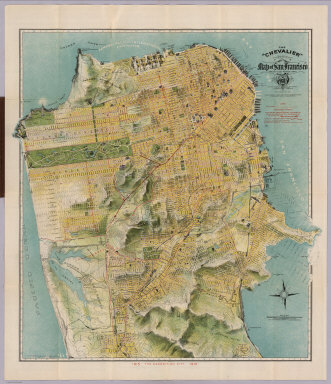
Author
Chevalier, August
Full Title
The "Chevalier" Commercial, Pictorial and Tourist Map of San Francisco From Latest U.S. Gov. and Official Surveys. Designed-Engraved And Copyrighted By Aug. Chevalier, Lithographer Publisher, 507 Mission St. San Francisco ... The Exposition City 1915. Copyrighted 1912 By Aug. Chevalier ... (on verso) Untitled index to the street, parks, Public Schools ... of San Francisco.
Publisher
August Chevalier
Author
Security Savings Bank
Full Title
Security Map And Street Railway Guide of the City of Los Angeles and Vicinity with Map of Beaches and nearby Points of Interest. Copyright 1908 by Security Savings Bank Los Angeles, California ... Presented Free With Compliments Of Security Savings Bank. Security Bldg. Spring And Fifth Sts. (inset) Extension Of Hollywood. (inset) Extension Of Garvanza South Pasadena. (inset) Map Showing The "Shoestring" Annexed to the City of Los Angeles. (on verso, map of the Vicinity of Los Angeles) Security Map 1907. (on verso) Depot Lines.
Publisher
Security Savings Bank
Author
Tanner, Henry S.
Full Title
A Map Of The United States Of Mexico, As organized and defined by the several Acts of the Congress of that Republic. Constructed from a great variety of Printed and Manuscript Documents by H.S. Tanner. Third Edition, 1846. Published by H.S. Tanner. Entered ... 1846, by H.S. Tanner ... New York. (inset) Map Of The Roads &c. From Vera Cruz & Alvarado To Mexico.
Publisher
H.S. Tanner
Author
[Gibbes, C.D., Holt, Warren]
Full Title
Map of the States Of California And Nevada. Carefully Compiled from the Latest Authentic Sources. By Chas. Drayton Gibbes, C.E. Comprising Information obtained from the U.S. Coast And Land Surveys ... And Others. Published by Warren Holt. No. 607 Clay Street, San Francisco, Cal. 1873. Entered ... 1873 by Warren Holt ... Washington. S. Blinton Formerly of the U.S. Coast Survey Draughtsman & Lithographer. 148-1/2 S. Fourth Street, Philadelphia, Pa.
Publisher
Warren Holt
Author
Hartmann, Carl
Full Title
Die wichtigsten Hafen und Rheden, sowie die Goldregion von Californien. (with 10 maps:) Bai und Hafen von San Francisco. Der Hafen San Pedro. Das Stromgebiet des San Sacramento nebst den Goldlager-statten. Der Haven von San Francisco. Bai und Hafen von MonteRey. Mundungen der Flusse Colorado und Gila. Bai und Hafen von San Diego. Bai und Hafen von Santa Barbara. Der Hafen von la Paz und Bai von Pichilingue. Die Bai la Trinidad. Alfr. Hartmann, Architect, entworf. Zu Hartmanns zweiten Bericht uber Californien. Weimar, 1849. Verlag und Lithographie von B.F. Voigt.
Publisher
Bernh. Fr. Voigt
Author
Britton & Rey
Full Title
Britton & Rey's Guide Map of the City of San Francisco. 1887. Copyright. (with) Geo. F. Schild's Map Attachment. Patented Dec. 8th 1885.
Publisher
Britton & Rey
Author
Eddy, William M.
Full Title
Approved and declared to be the official map of the State of California by an act of the Legislature passed March 25th 1853. Compiled by W.M. Eddy State Surveyor General. Published for R.A. Eddy, Marysville, California by J.H. Colton, No. 86 Cedar St. New York 1854. Authorities --- (with inset:) San Francisco and Adjoining Bays. Engraved on stone by Schedler & Liebler, 129 William St. New York. Printed by D. McLellan, 26 Spruce St. N.Y. Entered according to act of Congress in the year 1853 by Wm. M. Eddy in the Clerk's Office of the District Court of the United States for the Northern District of California.
Publisher
R.A. Eddy
Author
[Rhea, J. J., Sierra Art & Engraving Co.]
Full Title
Alameda County, California. Sierra Art & Eng. Designed by J.J. Rhea, Oakland, Cal. Printed by Kelley-Davis Co., Oakland, Cal. (1914)
Publisher
Kelley-Davis Co.
Author
[Bancroft, H.H., (Knight, W.H.)]
Full Title
Bancroft's Map Of California And Nevada. Published By H.H. Bancroft & Co. Booksellers & Stationers San Francisco Cal. 1868. Entered ... 1868 by H.H. Bancroft & Company ... California.
Publisher
H.H. Bancroft & Co.
Author
Free House Renting Bureau (Sterling Furniture company, Bunster & Saxe).
Full Title
(untitled view map of San Francisco). (on verso) Free Map of San Francisco. Free House Renting Bureau ... Sterling Furniture Company Bunster & Saxe 1049 Market St., Opposite Granada Theater.
Publisher
Free House Renting Bureau
Author
Faust, H.W.
Full Title
Faust's Map Of City And County Of San Francisco California. Published By H.W. Faust. Latest Edition 1903. Copyrighted by H.W. Faust, 1903. Galloway Litho. Co. S.F. (inset) General View Of San Francisco Bay.
Publisher
H.W. Faust
|