Who What Where WhenREMOVE |
Author
Blanchard, Rufus
Full Title
Map Of Chicago. Rufus Blanchard, 52 La Salle Street. 1857.
Publisher
R. Blanchard
Author
Blanchard, Rufus
Full Title
Guide Map of Chicago. Published by Rufus Blanchard, 146 Lake St. 1868. Lith. Chas. Shober & Co.
Publisher
Rufus Blanchard
Author
Blanchard, Rufus
Full Title
Map Of Chicago And Environs. Compiled And Published By Rufus Blanchard, Chicago, 146 Lake St. Illinois. 1869.
Publisher
Rufus Blanchard
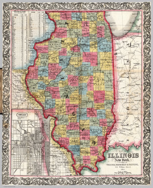
Author
Blanchard, Rufus
Full Title
Blanchard's Township Map of Illinois Showing all the Rail Roads, Stations, and Towns, Being a complete Shippers Guide to the State with parts of Iowa and Missouri. Drawn from plats of each County by Official Authority. Published by Rufus Blanchard 52 La Salle St. Chicago. 1864. Entered ... 1863 by R. Blanchard ... Illinois.
Publisher
Rufus Blanchard
Author
[Blanchard, Rufus, Walling, H. F.]
Full Title
Sectional Map of Illinois Showing the Botany, Topography & Geology of the State. Drawn by Prof. Walling. Compiled And Published By Rufus Blanchard. Chicago, 146 Lake St. Illinois. 1869. Entered ... 1869, by R. Blanchard ... Illinois. (inset) Geological Map Of Illinois. (inset) Illinois Geological Survey Longitudinal Section of the Mississippi River Bluffs, from Dunleith to Cairo.
Publisher
Rufus Blanchard
Author
[Mathewson, A. J., Messinger, John, Peck, J. M.]
Full Title
New Sectional Map Of the State of Illinois. Compiled From The United States Surveys. Also exhibiting the Internal Improvements, distances between Towns, Villages & Post Offices, the outlines of Prairies, Woodlands, Marshes & the lands donated to the State by the Gen. Govt. for the purpose of Internal Improvements. By J.M. Peck, John Messinger, And A.J. Mathewson. Published by J.H. Colton & Co. New-York. 1854. Engraved by S. Stiles & Co., N. York. Entered ... 1853 by J.H. Colton & Co. ... New York. (inset) Vicinity of Alton & St. Louis. (inset) Vicinity Of Galena, The Lead Region And Part Of Wisconsin And Iowa.
Publisher
J.H. Colton & Co.
Author
[Messinger, John, Peck, J. M., Colton, J.H., Mathewson, A.J.]
Full Title
Colton's New Sectional Map Of the State of Illinois. Compiled From The United States Surveys. Also exhibiting the Internal Improvements, distances between Towns, Villages & Post Offices, the outlines of Prairies, Woodlands, Marshes & the lands donated to the State by the Gen. Govt. for the purpose of Internal Improvements. By J.M. Peck, John Messinger, And A.J. Mathewson. Published by J.H. Colton, No. 172 William Street, New York. 1860. Entered ... 1836 by J.H. Colton & Co. ... New York. (inset) The City Of Chicago Illinois. (inset) The City Of St. Louis Missouri.
Publisher
J.H. Colton & Co.
Author
[Colton, G. W. & C. B., Messinger, John, Peck, J. M., Mathewson, A.J.]
Full Title
Colton's Sectional Map Of the State of Illinois. Compiled From The United States Surveys. Also exhibiting the Internal Improvements, distances between Towns, Villages & Post Offices, the outlines of Prairies, Woodlands, Marshes & the lands donated to the State by the Gen. Govt. for the purpose of Internal Improvements. By J.M. Peck, John Messinger, And A.J. Mathewson. Published by G.W. And C.B. Colton, & Co., No. 172 William St., New York. 1867. Entered ... 1836 by J.H. Colton & Co ... New York. (inset) The City Of Chicago Illinois. (inset) The City Of St. Louis Missouri.
Publisher
G.W. & C.B. Colton & Co.
Author
Colton, J. H.
Full Title
Illinois. Published By J.H. Colton No. 86 Cedar St. New York. 1854. Entered ... 1853, by J.H. Colton ... New York. (inset) Vicinity of Chicago.
Publisher
J. H. Colton.
Author
Mitchell, Samuel Augustus
Full Title
Map of the States Of Ohio, Indiana And Illinois with the settled part of Michigan. Published by S. Augustus Mitchell Philadelphia: 1834. Sold by Mitchell & Hinman No. 6 North 5th St. Entered ... 1834 by S. Augustus Mitchell ... Pennsylvania. Engraved by J.H. Young. (inset) Lead Region East of the Mississippi River. (inset) Falls Of Ohio. (inset) Vicinity Of Cincinnati. (inset) Vicinity Of Detroit.
Publisher
S. Augustus Mitchell
Author
Colton, G.W. & C.B.
Full Title
Colton's Popular Series of Sectional Maps. Illinois. Published By G.W. & C.B. Colton & Co. 172 William St. New York. Rufus Blanchard Chicago Ill. 1872. For fuller details of the geography of this state refer to Coltons larger and more complete Sectional Map. Entered ... 1870 by G.W. & C.B. Colton & Co ... Washington.
Publisher
[G.W. & C.B. Colton., Rufus Blanchard]
Author
Mitchell, Samuel Augustus
Full Title
Map of the States Of Ohio, Indiana And Illinois with the settled part of Michigan. Published by S. Augustus Mitchell Philadelphia: 1837. Sold by Mitchell & Hinman No. 6 North 5th St. Entered ... 1834 by S. Augustus Mitchell ... Pennsylvania. Engraved by J.H. Young. (inset) Lead Region East of the Mississippi River. (inset) Falls Of Ohio. (inset) Vicinity Of Cincinnati. (inset) Vicinity Of Detroit.
Publisher
S. Augustus Mitchell
Author
Tanner, Henry S.
Full Title
Ohio And Indiana. By H.S. Tanner. 1827. Engraved & Published by H.S. Tanner, Philadelphia. Entered ... 24th day of May 1819, by Tanner, Vallance, Kearny & Co. ... Pennsylvania.
Publisher
H.S. Tanner
Author
Tanner, Henry S.
Full Title
Illinois And Missouri. By H.S. Tanner. 1836. Published by H.S. Tanner, Philadelphia. Entered ... 1836, by H.S. Tanner ... Pennsylvania. Engraved by H.S. Tanner & Assistants.
Publisher
H.S. Tanner
Author
Rand McNally and Company
Full Title
Rand, McNally & Co.'s Illinois. Rand, McNally & Co., Relief Plate Map Engravers, Chicago. (inset) Vicinity Of Davenport & Rock Island. (inset) Chicago And Vicinity. (with 57 page index) Rand, McNally & Co.'s Indexed Map of Illinois ... Chicago: Rand, McNally & Co. ... 77 and 79 Madison Street. (on verso) Entered ... 1878, by Rand, McNally & Co. ... Washington.
Publisher
Rand McNally & Co.
Author
Cram, George Franklin
Full Title
New Sectional Map Of The State Of Illinois. Engraved From Official Draughts Of Each County. Published by George F. Cram. Proprietor Of The Western Map Depot. 55. W. Lake Street, Chicago, Ill. 1873. Entered ... 1872, by G.F. Cram ... Washington. G.F. Cram Lith. Chicago. St. Louis Publisher, E.H. Ross. 313 Locust St. St. Louis, Mo.
Publisher
George F. Cram ; St. Louis: E.H. Ross.
Author
Tanner, Henry S.
Full Title
Illinois And Missouri. By H.S. Tanner. 1840. Published by H.S. Tanner, Philadelphia. Entered ... 1839, by H.S. Tanner ... Pennsylvania. Engraved by H.S. Tanner & Assistants.
Publisher
H.S. Tanner
Author
Blanchard, Rufus
Full Title
Blanchard's map of Chicago with the new street names. 1906.
Publisher
Rufus Blanchard
Author
[Hammond, John T., Squire, B.S.]
Full Title
Map of Illinois with a Plan of Chicago. Published by B.S. Squire Jr. New-York 1836. Entered ... 1st day of Decr. in the year 1835 by Bela S. Squire Jr. ... New York. Engd. by J.T. Hammond N. York. (inset) Chicago.
Publisher
B.S. Squire
Author
[Colton, J. H., Mathewson, A. J., Messinger, John, Peck, J. M.]
Full Title
New sectional map of the state of Illinois. Compiled from the United States surveys. Also exhibiting the internal improvements, distances between towns, villages & post offices, the outlines of prairies, woodlands, marshes & the lands donated to the state by the Gen. Govt. for the purpose of internal improvements. By J.M. Peck, John Messinger, and A.J. Mathewson. Published by J.H. Colton & Co. New-York. 1852. Engraved by S. Stiles & Co. N. York. Entered ... 1836 by J.H. Colton & Co. ... New York. (inset) Vicinity of Alton & St. Louis. (inset) Vicinity of Galena, the Lead Region and part of Wisconsin and Iowa.
Publisher
J.H. Colton & Co.
Author
Blanchard, Rufus
Full Title
Blanchard's guide map of Chicago. Published by Rufus Blanchard, 52 La Salle Street, 1862.
Publisher
Rufus Blanchard
Author
[Blanchard, Rufus, Rees, J. H.]
Full Title
Map of the counties of Cook, Dupage, Will, Kankakee, and parts of Kane & Kendall. Compiled by J.H. Rees. Published by Rufus Blanchard. Chicago. Lith. of Ed. Mendel, 170 Lake St., Chicago. (1862)
Publisher
Rufus Blanchard
Author
[Blanchard, Rufus, National School Furnishing Co.]
Full Title
Blanchard's guide map of Chicago. And suburbs south to Seventy First Street. National School Furnishing Co. 141-143 Wabash Ave. Chicago. 1886.
Publisher
National School Furnishing Co.
Author
[Blanchard, Rufus, National School Furnishing Co.]
Full Title
Blanchard's map of Chicago and environs 1887.
Publisher
National School Furnishing Co.
Author
Wilber, C.D.
Full Title
Wilber's Miniature Map Of Illinois Showing Railroads, Stations, Counties, Townships, Sections and Rivers. Diamond Edition. 1864. Engraved & printed by Chas. Shober Corner of Lake & Clark Streets Chicago.
Publisher
Chas. Shober
Author
Mendenhall, Edward
Full Title
A New Map Of Illinois, Exhibiting The Counties, Townships, Cities, Villages & Post Offices, the Railroads, Canals, Common Roads, and all other Internal Improvements. Published by E. Mendenhall Cincinnati 1866. Middleton, Strobridge & Co. Lith Cin. O. Entered ... 1855, by E. Mendenhall ... Ohio.
Publisher
Edward, Mendenhall
Author
Strong, Ezra
Full Title
The States Of Ohio Indiana & Illinois And Michigan Territory From the Latest Authorities. Published by Ezra Strong New York 1834.
Publisher
Ezra Strong.
Author
Thayer, Bridgman & Fanning
Full Title
Map Of Illinois. New York, Published By Thayer, Bridgman & Fanning, 156 William Street. 1853. Entered ... 1852 by Horace Thayer & Co. ... New York. (inset) Chicago.
Publisher
Thayer, Bridgman & Fanning
Author
Wangersheim, W.
Full Title
Map Of Illinois Published by Wm. Wangersheim 52 Franklin St. Chicago, Ill. For The North American Accident Association. Copyrighted.
Publisher
Wm. Wangersheim
Author
[Blanchard, Rufus, Cram, George]
Full Title
Guide Map of Chicago. 1867. Published By Blanchard & Cram 1868. 146 Lake St. Chicago, Ill.
Publisher
Blanchard & Cram
Author
Chapman, Silas
Full Title
Chapman's Township Map of the North West Compiled from the United States Surveys and other authentic Sources. Published by Dyer & Pasmore Milwaukee Wisconsin 1857. Entered ... in the Year 1857 by S. Chapman ... State of Wisconsin. Lith of Ferd Mayer & Co. 96 Fulton St. N.Y.
Publisher
Dyer & Pasmore.
Author
[Blanchard, Rufus, Morse, Charles W.]
Full Title
Morse's Map of Illinois. Published by Rufus Blanchard 52 La Salle St. Chicago. Entered ... 1854, by Rufus Blanchard ... New York. Taylor, Hoyt and Cook, Printers, 22 & 24 Frankfort-St., N.Y
Publisher
Rufus Blanchard
Author
Judson, L.
Full Title
(Covers to) Iowa. A sectional Map of the Black Hawk Purchase with a part of Illinois And Wisconsin. By L. Judson. Engd. by Doolittle & Munson Cini. Entered ... 1838, by L. Judson ... Ohio.
Publisher
Doolittle & Munson
Author
Judson, L.
Full Title
Iowa. A sectional Map of the Black Hawk Purchase with a part of Illinois And Wisconsin. By L. Judson. Engd. by Doolittle & Munson Cini. Entered ... 1838, by L. Judson ... Ohio.
Publisher
Doolittle & Munson
Author
Blanchard, Rufus
Full Title
(Covers to) Map Of Chicago. Rufus Blanchard, 52 La Salle Street. 1857.
Publisher
R. Blanchard
Author
Blanchard, Rufus
Full Title
(Covers to) Map Of Chicago And Environs. Compiled And Published By Rufus Blanchard, Chicago, 146 Lake St. Illinois. 1869. (with) Guide Map of Chicago. Published by Rufus Blanchard, 146 Lake St. 1868. Lith. Chas. Shober & Co. (with) Citizen's Guide For The City of Chicago. Companion to Blanchard's Map of Chicago. Published By Rufus Blanchard, 146 Lake Street, Chicago.
Publisher
Rufus Blanchard
Author
Blanchard, Rufus
Full Title
Blanchard's Map Of The North Western States. Showing the Counties, Towns, Railroads, Stations, Steam Boat Landing etc. Compiled From The Most Authentic Sources. Published by Rufus Blanchard, 148 Lake Street, Chicago, Ill. 1868. Lith. Chas. Shober & Co. Chicago. Entered ... 1865, by R. Blanchard ... Illinois.
Publisher
Rufus Blanchard
Author
Blanchard, Rufus
Full Title
(Covers to) Blanchard's Township Map of Illinois Showing all the Rail Roads, Stations, and Towns, Being a complete Shippers Guide to the State with parts of Iowa and Missouri. Drawn from plats of each County by Official Authority. Published by Rufus Blanchard 52 La Salle St. Chicago. 1864. Entered ... 1863 by R. Blanchard ... Illinois.
Publisher
Rufus Blanchard
Author
[Blanchard, Rufus, Walling, H. F.]
Full Title
(Covers to) Sectional Map of Illinois Showing the Botany, Topography & Geology of the State. Drawn by Prof. Walling. Compiled And Published By Rufus Blanchard. Chicago, 146 Lake St. Illinois. 1869. Entered ... 1869, by R. Blanchard ... Illinois. (inset) Geological Map Of Illinois. (inset) Illinois Geological Survey Longitudinal Section of the Mississippi River Bluffs, from Dunleith to Cairo.
Publisher
Rufus Blanchard
Author
[Mathewson, A. J., Messinger, John, Peck, J. M.]
Full Title
(Covers to) New Sectional Map Of the State of Illinois. Compiled From The United States Surveys. Also exhibiting the Internal Improvements, distances between Towns, Villages & Post Offices, the outlines of Prairies, Woodlands, Marshes & the lands donated to the State by the Gen. Govt. for the purpose of Internal Improvements. By J.M. Peck, John Messinger, And A.J. Mathewson. Published by J.H. Colton & Co. New-York. 1854. Engraved by S. Stiles & Co., N. York. Entered ... 1853 by J.H. Colton & Co. ... New York. (inset) Vicinity of Alton & St. Louis. (inset) Vicinity Of Galena, The Lead Region And Part Of Wisconsin And Iowa.
Publisher
J.H. Colton & Co.
Author
[Messinger, John, Peck, J. M., Colton, J.H., Mathewson, A.J.]
Full Title
(Covers to) Colton's New Sectional Map Of the State of Illinois. Compiled From The United States Surveys. Also exhibiting the Internal Improvements, distances between Towns, Villages & Post Offices, the outlines of Prairies, Woodlands, Marshes & the lands donated to the State by the Gen. Govt. for the purpose of Internal Improvements. By J.M. Peck, John Messinger, And A.J. Mathewson. Published by J.H. Colton, No. 172 William Street, New York. 1860. Entered ... 1836 by J.H. Colton & Co. ... New York. (inset) The City Of Chicago Illinois. (inset) The City Of St. Louis Missouri.
Publisher
J.H. Colton & Co.
Author
[Colton, G. W. & C. B., Messinger, John, Peck, J. M., Mathewson, A.J.]
Full Title
(Covers to) Colton's Sectional Map Of the State of Illinois. Compiled From The United States Surveys. Also exhibiting the Internal Improvements, distances between Towns, Villages & Post Offices, the outlines of Prairies, Woodlands, Marshes & the lands donated to the State by the Gen. Govt. for the purpose of Internal Improvements. By J.M. Peck, John Messinger, And A.J. Mathewson. Published by G.W. And C.B. Colton, & Co., No. 172 William St., New York. 1867. Entered ... 1836 by J.H. Colton & Co ... New York. (inset) The City Of Chicago Illinois. (inset) The City Of St. Louis Missouri.
Publisher
G.W. & C.B. Colton & Co.
Author
Colton, J. H.
Full Title
(Covers to) Illinois. Published By J.H. Colton No. 86 Cedar St. New York. 1854. Entered ... 1853, by J.H. Colton ... New York. (inset) Vicinity of Chicago.
Publisher
J. H. Colton.
Author
Mitchell, Samuel Augustus
Full Title
(Covers to) Map of the States Of Ohio, Indiana And Illinois with the settled part of Michigan. Published by S. Augustus Mitchell Philadelphia: 1834. Sold by Mitchell & Hinman No. 6 North 5th St. Entered ... 1834 by S. Augustus Mitchell ... Pennsylvania. Engraved by J.H. Young. (inset) Lead Region East of the Mississippi River. (inset) Falls Of Ohio. (inset) Vicinity Of Cincinnati. (inset) Vicinity Of Detroit.
Publisher
S. Augustus Mitchell
Author
Colton, G.W. & C.B.
Full Title
(Covers to) Colton's Popular Series of Sectional Maps. Illinois. Published By G.W. & C.B. Colton & Co. 172 William St. New York. Rufus Blanchard Chicago Ill. 1872. For fuller details of the geography of this state refer to Coltons larger and more complete Sectional Map. Entered ... 1870 by G.W. & C.B. Colton & Co ... Washington.
Publisher
[G.W. & C.B. Colton., Rufus Blanchard]
Author
Mitchell, Samuel Augustus
Full Title
(Covers to) Map of the States Of Ohio, Indiana And Illinois with the settled part of Michigan. Published by S. Augustus Mitchell Philadelphia: 1837. Sold by Mitchell & Hinman No. 6 North 5th St. Entered ... 1834 by S. Augustus Mitchell ... Pennsylvania. Engraved by J.H. Young. (inset) Lead Region East of the Mississippi River. (inset) Falls Of Ohio. (inset) Vicinity Of Cincinnati. (inset) Vicinity Of Detroit.
Publisher
S. Augustus Mitchell
Author
Mitchell, Samuel Augustus
Full Title
Map of the States Of Ohio, Indiana And Illinois with the settled part of Michigan. Published by S. Augustus Mitchell Philadelphia: 1837. Sold by Mitchell & Hinman No. 6 North 5th St. Entered ... 1834 by S. Augustus Mitchell ... Pennsylvania. Engraved by J.H. Young. (inset) Lead Region East of the Mississippi River. (inset) Falls Of Ohio. (inset) Vicinity Of Cincinnati. (inset) Vicinity Of Detroit.
Publisher
S. Augustus Mitchell
Author
Rand McNally and Company
Full Title
Rand McNally & Co's Historical Description And Guide Map Of Chicago ... Chicago: Rand, McNally & Co., Printers And Engravers, 77 and 79 Madison Street. (on verso) Entered ... 1879, by Rand, McNally & Co. ... Washington. (with) Map Showing The Boulevards And Park System And Twelve Miles of Lake Frontage Of The City Of Chicago. Engraved By Rand, McNally & Co. ... Entered ... 1879, by Rand, McNally & Co. ... Washington, D.C. ...
Publisher
Rand McNally & Co.
Author
Rand McNally and Company
Full Title
Map Showing The Boulevards And Park System And Twelve Miles of Lake Frontage Of The City Of Chicago. Engraved By Rand, McNally & Co. ... Entered ... 1879, by Rand, McNally & Co. ... Washington, D.C. ... (with) Rand McNally & Co's Historical Description And Guide Map Of Chicago ... Chicago: Rand, McNally & Co., Printers And Engravers, 77 and 79 Madison Street. (on verso) Entered ... 1879, by Rand, McNally & Co. ... Washington.
Publisher
Rand McNally & Co.
Author
Tanner, Henry S.
Full Title
(Covers to) Ohio And Indiana. By H.S. Tanner. 1827. Engraved & Published by H.S. Tanner, Philadelphia. Entered ... 24th day of May 1819, by Tanner, Vallance, Kearny & Co. ... Pennsylvania.
Publisher
H.S. Tanner
|