Who What Where When |
REFINE
Browse All : Vegetation and Population and Climate of Ukraine and Russia
1-10 of 10
Author
Mitchell, Samuel Augustus
Full Title
Map Of The States Of North Carolina South Carolina and Georgia. Philadelphia: Published by S. Augustus Mitchell. 1836. Sold By Mitchell & Hinman No. 6 North Fifth Street. Entered ... 1835, by S. Augustus Mitchell ... Pennsylvania. Engraved by J.H. Young. (inset) Vicinity Of Charleston.
Publisher
S. Augustus Mitchell
Author
Tanner, Henry S.
Full Title
Map Of North & South Carolina. By H.S. Tanner. 1840. Published by H.S. Tanner, Philadelphia. Engraved by H.S. Tanner & Assistants. (above the neat line) American Atlas.
Publisher
H.S. Tanner
Author
[Kerr, W.C., Guyot, Arnold]
Full Title
Map Of North Carolina, By W.C. Kerr, State Geologist; Assisted by Capt. Wm. Cain, C.E. Published Under The Authority Of The State Board Of Agriculture. 1882. Constructed From Original Surveys And Triangulations Of The U.S. Coast And Geodetic Survey, Of Prof. Guyot, Of The State Geologist, And Of the U.S. Engineers; And Embodying The Surveys Made By The State From 1820 To Date ... Julius Bien & Co. Lith. N.Y. Entered ... 1882, by W.C. Kerr ... Washington.
Publisher
Julius Bien & Co.
Author
Colton, G.W. & C.B.
Full Title
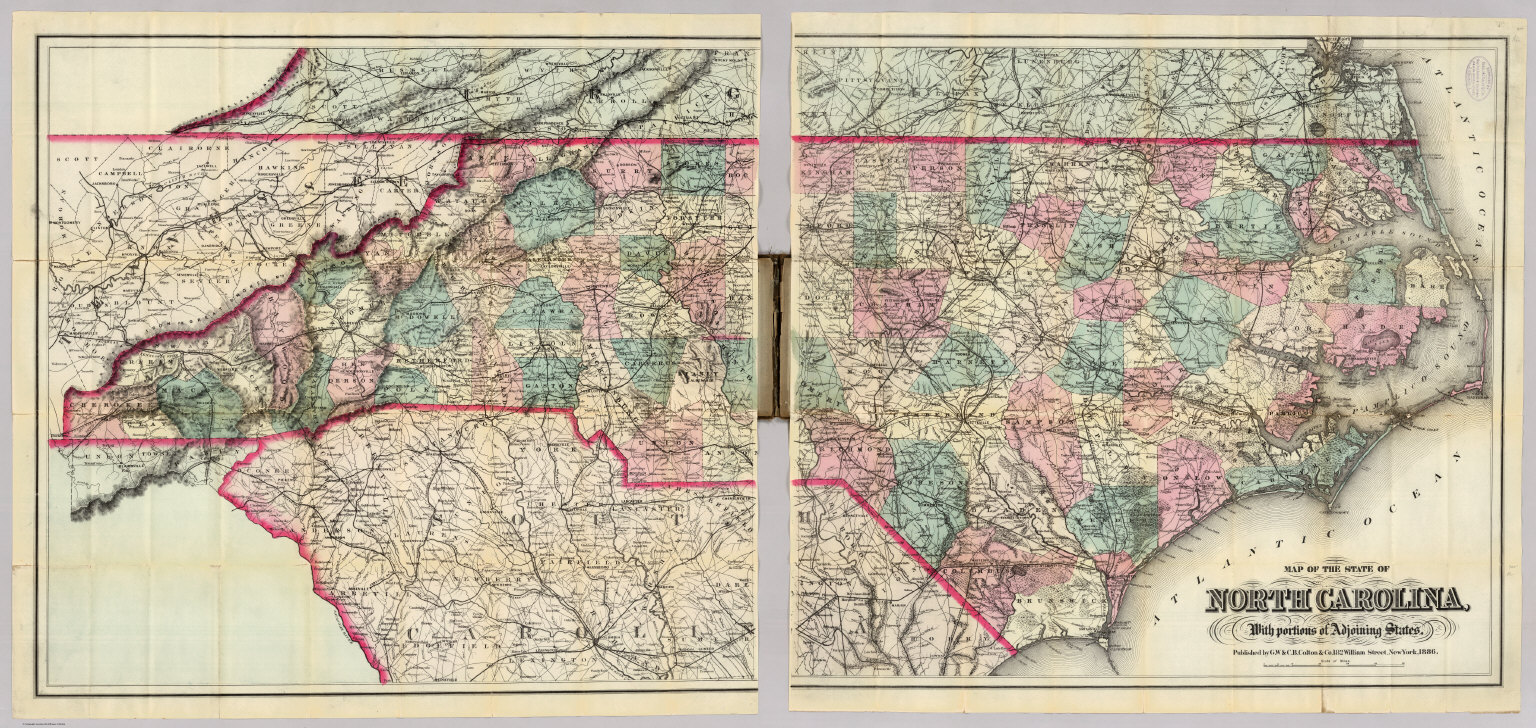
Map Of The State Of North Carolina, With Portions Of Adjoining States. Published by G.W. & C.B. Colton & Co. 182 William Street, New York, 1886.
Publisher
G.W. & C.B. Colton
Author
Colton, G.W. & C.B.
Full Title
(Composite of) Map Of The State Of North Carolina, With Portions Of Adjoining States. Published by G.W. & C.B. Colton & Co. 182 William Street, New York, 1886.
Publisher
G.W. & C.B. Colton
Author
Mitchell, Samuel Augustus
Full Title
(Covers to) Map Of The States Of North Carolina South Carolina and Georgia. Philadelphia: Published by S. Augustus Mitchell. 1836. Sold By Mitchell & Hinman No. 6 North Fifth Street. Entered ... 1835, by S. Augustus Mitchell ... Pennsylvania. Engraved by J.H. Young. (inset) Vicinity Of Charleston.
Publisher
S. Augustus Mitchell
Author
Tanner, Henry S.
Full Title
(Covers to) Map Of North & South Carolina. By H.S. Tanner. 1840. Published by H.S. Tanner, Philadelphia. Engraved by H.S. Tanner & Assistants. (above the neat line) American Atlas.
Publisher
H.S. Tanner
Author
[Kerr, W.C., Guyot, Arnold]
Full Title
(Covers to) Map Of North Carolina, By W.C. Kerr, State Geologist; Assisted by Capt. Wm. Cain, C.E. Published Under The Authority Of The State Board Of Agriculture. 1882. Constructed From Original Surveys And Triangulations Of The U.S. Coast And Geodetic Survey, Of Prof. Guyot, Of The State Geologist, And Of the U.S. Engineers; And Embodying The Surveys Made By The State From 1820 To Date ... Julius Bien & Co. Lith. N.Y. Entered ... 1882, by W.C. Kerr ... Washington.
Publisher
Julius Bien & Co.
Author
Asher & Adams
Full Title
Asher & Adams' New Commercial And Topographical Rail-Road Map And Guide Of North Carolina And South Carolina. Comprising A New Map, Colored By Counties, On A Scale Of Twenty Miles To An Inch; Delineating Rivers, Landings, Railroads, Stations with Distances, Etc. ... New York: American Rail Road Map And Guide Publishing Company, 39 Beekman Street. Entered... in the year one thousand eight hundred and seventy-four, by Asher & Adams ... Washington. (with map) Asher & Adams' North Carolina And South Carolina. Entered ... 1874 by Asher & Adams ... Washington.
Publisher
American Rail Road Map And Guide Publishing Company
Author
Colton, G.W. & C.B.
Full Title
(Covers to) Map Of The State Of North Carolina, With Portions Of Adjoining States. Published by G.W. & C.B. Colton & Co. 182 William Street, New York, 1886.
Publisher
G.W. & C.B. Colton
1-10 of 10
|