Who What Where WhenREMOVEWHERE
|
REFINE
Browse All : Pocket Map of Rhode Island
1-21 of 21
Author
Cram, George Franklin
Full Title
Commercial Railroad and County Map Of Massachusetts and Rhode Island. Published by Geo. F. Cram, Chicago, Ill. Geo. F. Cram, Engraver & Publisher, Chicago Ill. (inset: untitled map of the Boston area).
Publisher
George F. Cram
Author
Mitchell, Samuel Augustus
Full Title
Map Of Massachusetts Connecticut And Rhode Island Constructed From the Latest Authorities. Published by S. Augustus Mitchell Philadelphia. 1831. J.H. Young Sc. (inset) Statistical Table. Pop... for all three states.
Publisher
S. Augustus Mitchell
Author
Tanner, Henry S.
Full Title
Massachusetts And Rhode Island: By H.S. Tanner. Published by C.S. Williams ... Philadelphia. 1846. Entered ... in the year 1841, by H.S. Tanner in the ... Eastern District of Pennsylvania. (inset map) Boston.
Publisher
C.S. Williams
Author
Finley, Anthony
Full Title
Rhode Island. (Pocket Atlas Of The New England States And New York). (with 7 maps) Connecticut, New York. Maine. New Hampshire. Vermont. Massachusetts. Rhode Island. Published by A. Finley Philada. Young & Delleker Sc.
Publisher
Anthony Finley
Author
Morse, Sidney E.
Full Title
Massachusetts, Rhode-Island And Connecticut. On the Improved Plan of Sidney E. Morse, A.M. Entered ... second day of May, 1827, By Sidney E. Morse ... Connecticut. Published by N. & S.S. Jocelyn, New-Haven, Con. 1827. N. & S.S. Jocelyn Sc. (inset) Boston and its Vicinity.
Publisher
N. & S.S. Jocelyn
Author
[DeSilver, Robert, Payne, John]
Full Title
Map of Rhode-Island. Published In 1826. W. Barker sculp. Philada.
Publisher
No Publisher.
Author
Barber, John Warner
Full Title
Massachusetts & Rhode Island.
Publisher
J.W. Barber
Author
Brown & Parsons
Full Title
Map Of Massachusetts, Connecticut And Rhode Island Constructed from the Latest Authorities. Published by Brown & Parsons Hartford, Ct. 1847.
Publisher
Brown & Parsons.
Author
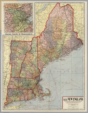
Kenyon Company
Full Title
Map of New England ... Copyright 1920 The Kenyon Company, Inc., Map Makers Des Moines, Iowa. Principal Automobile Highways Shown Thus ... (inset) Eastern Portion Of Massachusetts. (on verso) Index of New England States, With Official 1920 Census...
Publisher
The Kenyon Company, Inc.
Author
Cram, George Franklin
Full Title
(Covers to) Commercial Railroad and County Map Of Massachusetts and Rhode Island. Published by Geo. F. Cram, Chicago, Ill. Geo. F. Cram, Engraver & Publisher, Chicago Ill. (inset: untitled map of the Boston area).
Publisher
George F. Cram
Author
Cram, George Franklin
Full Title
(Title Page to) Commercial Railroad and County Map Of Massachusetts and Rhode Island. Published by Geo. F. Cram, Chicago, Ill. Geo. F. Cram, Engraver & Publisher, Chicago Ill. (inset: untitled map of the Boston area).
Publisher
George F. Cram
Author
Mitchell, Samuel Augustus
Full Title
(Covers to) Map Of Massachusetts Connecticut And Rhode Island Constructed From the Latest Authorities. Published by S. Augustus Mitchell Philadelphia. 1831. J.H. Young Sc. (inset) Statistical Table. Pop... for all three states.
Publisher
S. Augustus Mitchell
Author
Tanner, Henry S.
Full Title
(Covers to) Massachusetts And Rhode Island: By H.S. Tanner. Published by C.S. Williams ... Philadelphia. 1846. Entered ... in the year 1841, by H.S. Tanner in the ... Eastern District of Pennsylvania. (inset map) Boston.
Publisher
C.S. Williams
Author
Morse, Sidney E.
Full Title
(Covers to) Massachusetts, Rhode-Island And Connecticut. On the Improved Plan of Sidney E. Morse, A.M. Entered ... second day of May, 1827, By Sidney E. Morse ... Connecticut. Published by N. & S.S. Jocelyn, New-Haven, Con. 1827. N. & S.S. Jocelyn Sc. (inset) Boston and its Vicinity.
Publisher
N. & S.S. Jocelyn
Author
Andrus & Judd
Full Title
(Covers to) The States Of Massachusetts, Connecticut And Rhode Island From the best Authorities. Published by Andrus & Judd Hartford, Conn. 1832. Copy Right secured according to Act of Congress.
Publisher
Andrus & Judd
Author
Andrus & Judd
Full Title
The States Of Massachusetts, Connecticut And Rhode Island From the best Authorities. Published by Andrus & Judd Hartford, Conn. 1832. Copy Right secured according to Act of Congress.
Publisher
Andrus & Judd
Author
[DeSilver, Robert, Payne, John]
Full Title
(Covers to) (Untitled Pocket Atlas of Four Maps). (with) Map of Rhode-Island. Published In 1826. W. Barker sculp. Philada. (with) Map of Connecticut, Published In 1826. A. Anderson, Del. (with) State Of New Jersey. Engraved for New Encyclopedia Published by J. Low, New York. W. Barker sculp. Philada. (with) The State of South Carolina from the best Authorities 1831. Engraved for New Encyclopedia ... (map cut off below this point).
Publisher
No Publisher.
Author
Barber, John Warner
Full Title
(Covers to) Massachusetts & Rhode Island.
Publisher
J.W. Barber
Author
Brown & Parsons
Full Title
(Covers to) Map Of Massachusetts, Connecticut And Rhode Island Constructed from the Latest Authorities. Published by Brown & Parsons Hartford, Ct. 1847.
Publisher
Brown & Parsons.
Author
Kenyon Company
Full Title
(Covers to) Map of New England ... Copyright 1920 The Kenyon Company, Inc., Map Makers Des Moines, Iowa. Principal Automobile Highways Shown Thus ... (inset) Eastern Portion Of Massachusetts. (on verso) Index of New England States, With Official 1920 Census...
Publisher
The Kenyon Company, Inc.
Author
Kenyon Company
Full Title
(Text page to) Map of New England ... Copyright 1920 The Kenyon Company, Inc., Map Makers Des Moines, Iowa. Principal Automobile Highways Shown Thus ... (inset) Eastern Portion Of Massachusetts. (on verso) Index of New England States, With Official 1920 Census...
Publisher
The Kenyon Company, Inc.
1-21 of 21
|