Who What Where WhenREMOVE |
Author
[Fisher, Richard Swainson, Dinsmore & Co.]
Full Title
Dinsmore's Complete Map Of The Railroads & Canals In The United States & Canada Carefully Compiled from Authentic Sources by Richard S. Fisher, Editor Of The American Rail Road & Steam Navigator Guide. New-York. Published By Dinsmore & Company, No. 9 Spruce St. Engraved In Relief For Power Press Printing by Schonberg & Co. Acrographers, 75 Nassau Street New York 1856. Entered ... 1856 by Dinsmore & Co. ... New York.
Publisher
Dinsmore & Company
Author
Colton, G.W. & C.B.
Full Title
Map showing the Line of The New Haven, Middletown And Boston Railroad and its connections. Published by G.W. And C.B. Colton, & Co. 172 William St. New York. 1867. Entered ... 1867 by G.W. & C.B. Colton & Co ... New York.
Publisher
G.W. & C.B. Colton.
Author
Rand McNally and Company
Full Title
Rand McNally Junior Road Map New England. Copyright By Rand McNally & Co. Chicago Ill. Made In U.S.A. ...
Publisher
Rand McNally & Co.
Author
Williams, Alexander
Full Title
Telegraph and Rail Road Map of the New England States, by Alex. Williams. 1855. Redding & Co. Publishers, 8 State Street, Boston. Entered ... 1854 by Alexander Williams ... Massachusetts. (with inset map) Map of Boston Showing the entrance of the Rail Roads, by Alexr. Williams. Boynton Sc.
Publisher
Redding & Co.
Author
Tanner, Henry S.
Full Title
Map Of The States Of Maine, New Hampshire, Vermont, Massachusetts, Connecticut & Rhode Island. By H.S. Tanner 1847. Engraved & Published by H.S. Tanner, Philadelphia.
Publisher
H.S. Tanner
Author
Finley, Anthony
Full Title
Connecticut. (Pocket Atlas Of The New England States And New York). (with 7 maps) Connecticut, New York. Maine. New Hampshire. Vermont. Massachusetts. Rhode Island. Published by A. Finley Philada. Young & Delleker Sc.
Publisher
Anthony Finley
Author
Finley, Anthony
Full Title
New York. (Pocket Atlas Of The New England States And New York). (with 7 maps) Connecticut, New York. Maine. New Hampshire. Vermont. Massachusetts. Rhode Island. Published by A. Finley Philada. Young & Delleker Sc.
Publisher
Anthony Finley
Author
Finley, Anthony
Full Title
Maine. (Pocket Atlas Of The New England States And New York). (with 7 maps) Connecticut, New York. Maine. New Hampshire. Vermont. Massachusetts. Rhode Island. Published by A. Finley Philada. Young & Delleker Sc.
Publisher
Anthony Finley
Author
Finley, Anthony
Full Title
New Hampshire. (Pocket Atlas Of The New England States And New York). (with 7 maps) Connecticut, New York. Maine. New Hampshire. Vermont. Massachusetts. Rhode Island. Published by A. Finley Philada. Young & Delleker Sc.
Publisher
Anthony Finley
Author
Finley, Anthony
Full Title
Vermont. (Pocket Atlas Of The New England States And New York). (with 7 maps) Connecticut, New York. Maine. New Hampshire. Vermont. Massachusetts. Rhode Island. Published by A. Finley Philada. Young & Delleker Sc.
Publisher
Anthony Finley
Author
Finley, Anthony
Full Title
Massachusetts. (Pocket Atlas Of The New England States And New York). (with 7 maps) Connecticut, New York. Maine. New Hampshire. Vermont. Massachusetts. Rhode Island. Published by A. Finley Philada. Young & Delleker Sc.
Publisher
Anthony Finley
Author
Finley, Anthony
Full Title
Rhode Island. (Pocket Atlas Of The New England States And New York). (with 7 maps) Connecticut, New York. Maine. New Hampshire. Vermont. Massachusetts. Rhode Island. Published by A. Finley Philada. Young & Delleker Sc.
Publisher
Anthony Finley
Author
Kenyon Company
Full Title
Map Of New England With population and Location of the Principal Towns and Cities according to Latest Reliable Statistics ... Copyrighted 1910 by The Kenyon Company, Map Makers, Des Moines, Iowa. (on verso) Location and Population of towns and Cities in New England According to the United States Census of 1910.
Publisher
The Kenyon Company
Author
Wyld, James, 1812-1887
Full Title
Wyld's Military Map Of The United States, The Northern States, And The Southern Confederate States: With The Forts, Harbours, Arsenals And Military Positions. James Wyld, 457 Strand; Charing Cross East And 2, Royal Exchange London. London, Published By James Wyld, Geographer To The Queen & H.R.H. The Prince Consort ... (with 4 inset maps).
Publisher
James Wyld
Author
Goldthwait, J.H.
Full Title
Railroad Map Of New England & Eastern New York, Compiled from the most authentic sources. By J.H. Goldthwait. 1849. Boston. Redding & Co. 8 State St. New York. Clark, Austin & Co. 205 Broadway. Entered ... 1849, by J.H. Goldthwait ... New York. (inset) Boston & Vicinity, Showing the Grand Junction R.R.
Publisher
Redding & Co.
Author
[Colton, G.W. & C.B., Howland, S.A.]
Full Title
Commercial Map of New England. Worcester Mass. S.A. Howland 1871. G.W. & C.B. Colton & Co. New York. (inset) The Northern Portion Of Maine. (with an 18 page index) Commercial Travelers' Pocket Map Of New England, Eastern New York And Long Island, Together With A Complete Census Of The New England States In 1860 and 1870. Worcester, Mass., Published By S.A. Howland. 1871. Entered ... 1871, by S.A. Howland, of Massachusetts ...
Publisher
S.A. Howland
Author
[Frey, A.C., Nell, Louis]
Full Title
Frey & Nell's New England. Railroad, Topographical & Township Map of the States of Connecticut, Rhode Island, Massachusetts, Vermont, New Hampshire and Maine. New York, H.H. Lloyd & Co. Publishers, 21 John St. Concord, N.H. D.L. Guernsey & Co. 1867 ... American Photo-Lithographic Co. N. York. Osborne's Process. Entered ... 1867, by Frey & Nell ... New York. (untitled inset of Maine).
Publisher
[H.H. Lloyd & Co., D.L. Guernsey & Co.]
Author
[Smith, J. Calvin, Colton, J.H.]
Full Title
Colton's Map of the States of New England And New York, With Parts Of Pennsylvania, New Jersey, The Canadas &c. Showing The Railroads, Canals, and Stage Roads With distances from place to place. Drawn by George W. Colton. Engraved by J.M Atwood N.Y. New York Published By J.H. Colton And Co. No. 172 William St. 1856. (with four inset maps). (with map) Guide Through Ohio, Michigan, Indiana, Illinois, Missouri, Wisconsin & Iowa Showing The Township lines of the United States Surveys ... by J. Calvin Smith. New York. Published by J.H. Colton. 86 Cedar St. 1853. Engraved by S.Stiles, Sherman & Smith. D. Mc. Lellan, Print. 26 Spruce St. N.Y.
Publisher
J.H. Colton
Author
[Smith, J. Calvin, Colton, J.H.]
Full Title
Guide Through Ohio, Michigan, Indiana, Illinois, Missouri, Wisconsin & Iowa Showing The Township lines of the United States Surveys ... by J. Calvin Smith. New York. Published by J.H. Colton. 86 Cedar St. 1853. Engraved by S.Stiles, Sherman & Smith. D. Mc. Lellan, Print. 26 Spruce St. N.Y. (with map) Colton's Map of the States of New England And New York, With Parts Of Pennsylvania, New Jersey, The Canadas &c. Showing The Railroads, Canals, and Stage Roads With distances from place to place. Drawn by George W. Colton. Engraved by J.M Atwood N.Y. New York Published By J.H. Colton And Co. No. 172 William St. 1856. (with four inset maps).
Publisher
J.H. Colton
Author
Smith, J. Calvin
Full Title
Sherman & Smith's Railroad, Steam Boat & Stage Route Map Of New England, New-York And Canada. By J. Calvin Smith. Published by Sherman & Smith 135 Broadway. N.Y. MDCCCL. Entered ... 1850 by Sherman & Smith ... (inset) 15 Miles Around Boston. (inset) 15 Miles Around New York.
Publisher
Sherman & Smith
Author
G.W. & C.B. Colton & Co.
Full Title
Map of the Richmond and Louisville R.R. connecting the railroads of Virginia with the railroads of Kentucky on the shortest route east and west from the Mississippi Valley to the Atlantic Ocean. Engraved, printed and manufactured by G.W. & C.B. Colton & Co. No. 182 William St. New York. Entered ... 1882 by G.W. & C.B. Colton & Co. ... at Washington.
Publisher
G.W. & C.B. Colton & Co.
Author
Dawson Brothers
Full Title
Dawson's Map Of The Dominion Of Canada. 1872. Dawson Brothers, Montreal. Engraved & Printed in Colours by J. Bartholomew, Edinburgh. (inset) Newfoundland. (inset) Environs Of Montreal. (inset) Continuation Of The Map To The Pacific, Showing British Columbia & Manitoba.
Publisher
Dawson Brothers
Author
Westgard, A.L.
Full Title
The New England States. Compiled and published by A.L. Westgard & Co. Providence, R.I. Copyright 1896 by A.L. Westgard & Co. (inset) North Part Of Maine. (inset) Environs Of Boston.
Publisher
A.L. Westgard
Author
Dawson Brothers
Full Title
New Map Of The Dominion Of Canada. Dawson Brothers, Montreal. 1870. Engraved & Printed in Colours by J. Bartholomew, Edinburgh. (inset) Newfoundland. (inset) Environs Of Montreal.
Publisher
Dawson Brothers
Author
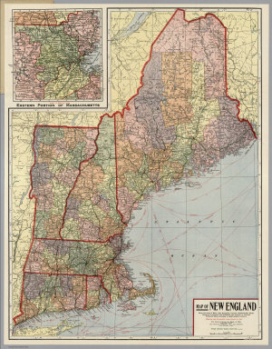
Kenyon Company
Full Title
Map of New England ... Copyright 1920 The Kenyon Company, Inc., Map Makers Des Moines, Iowa. Principal Automobile Highways Shown Thus ... (inset) Eastern Portion Of Massachusetts. (on verso) Index of New England States, With Official 1920 Census...
Publisher
The Kenyon Company, Inc.
Author
Asher & Company
Full Title
The Historical War Map. Asher & Co. Entered ... 1862, by Asher & Co. ... Indiana. E.R. Jewett & Co. Engravers, Buffalo, N.Y.
Publisher
Asher & Company
Author
Hale, Nathan
Full Title
A Map of the New England States, Maine, New Hampshire, Vermont, Massachusetts, Rhode Island & Connecticut, With the adjacent parts of New York & Lower Canada. Compiled and Published By Nathan Hale, Boston 1826. Engraved by J.V.N. Throop. Revised Edition of 1853. Corrected by the addition of the Railroads, new towns, & other public improvements, to Feby. 1853. Entered ... February 1853, by Nathan Hale ... Massachusetts. (inset) Northern & Eastern Part Of Maine And Part Of Lower Canada And New Brunswick. With Corrections in 1853.
Publisher
Nathan Hale
Author
American Telephone and Telegraph Company
Full Title
Lines and Metallic Circuit Connections. American Telephone and Telegraph Co. 18 Cortlandt St. New York. March 1, 1891.
Publisher
No Publisher
Author
[Asher & Company, Russell, Benjamin B.]
Full Title
The Historical War Map. Asher & Co. Entered ... 1862, by Asher & Co. ... Indiana. E.R. Jewett & Co. Engravers, Buffalo, N.Y.
Publisher
Benjamin B. Russell
Author
[Fisher, Richard Swainson, Dinsmore & Co.]
Full Title
(Covers to) Dinsmore's Complete Map Of The Railroads & Canals In The United States & Canada Carefully Compiled from Authentic Sources by Richard S. Fisher, Editor Of The American Rail Road & Steam Navigator Guide. New-York. Published By Dinsmore & Company, No. 9 Spruce St. Engraved In Relief For Power Press Printing by Schonberg & Co. Acrographers, 75 Nassau Street New York 1856. Entered ... 1856 by Dinsmore & Co. ... New York.
Publisher
Dinsmore & Company
Author
Colton, G.W. & C.B.
Full Title
(Covers to) Map showing the Line of The New Haven, Middletown And Boston Railroad and its connections. Published by G.W. And C.B. Colton, & Co. 172 William St. New York. 1867. Entered ... 1867 by G.W. & C.B. Colton & Co ... New York.
Publisher
G.W. & C.B. Colton.
Author
Rand McNally and Company
Full Title
(Covers to) Rand McNally Junior Road Map New England. Copyright By Rand McNally & Co. Chicago Ill. Made In U.S.A. ...
Publisher
Rand McNally & Co.
Author
Williams, Alexander
Full Title
(Covers to) Telegraph and Rail Road Map of the New England States, by Alex. Williams. 1855. Redding & Co. Publishers, 8 State Street, Boston. Entered ... 1854 by Alexander Williams ... Massachusetts. (with inset map) Map of Boston Showing the entrance of the Rail Roads, by Alexr. Williams. Boynton Sc.
Publisher
Redding & Co.
Author
Tanner, Henry S.
Full Title
(Covers to) Map Of The States Of Maine, New Hampshire, Vermont, Massachusetts, Connecticut & Rhode Island. By H.S. Tanner 1847. Engraved & Published by H.S. Tanner, Philadelphia.
Publisher
H.S. Tanner
Author
Finley, Anthony
Full Title
(Covers to) (Pocket Atlas Of The New England States And New York). (with 7 maps) Connecticut. New York. Maine. New Hampshire. Vermont. Massachusetts. Rhode Island. Published by A. Finley Philada. Young & Delleker Sc.
Publisher
Anthony Finley
Author
Kenyon Company
Full Title
(Covers to) Map Of New England With population and Location of the Principal Towns and Cities according to Latest Reliable Statistics ... Copyrighted 1910 by The Kenyon Company, Map Makers, Des Moines, Iowa. (on verso) Location and Population of towns and Cities in New England According to the United States census of 1910.
Publisher
The Kenyon Company
Author
Kenyon Company
Full Title
(Text Page to) Map Of New England With population and Location of the Principal Towns and Cities according to Latest Reliable Statistics ... Copyrighted 1910 by The Kenyon Company, Map Makers, Des Moines, Iowa. (on verso) Location and Population of towns and Cities in New England According to the United States Census of 1910.
Publisher
The Kenyon Company
Author
Wyld, James, 1812-1887
Full Title
(Covers to) Wyld's Military Map Of The United States, The Northern States, And The Southern Confederate States: With The Forts, Harbours, Arsenals And Military Positions. James Wyld, 457 Strand; Charing Cross East And 2, Royal Exchange London. London, Published By James Wyld, Geographer To The Queen & H.R.H. The Prince Consort ... (with 4 inset maps).
Publisher
James Wyld
Author
Goldthwait, J.H.
Full Title
(Covers to) Railroad Map Of New England & Eastern New York, Compiled from the most authentic sources. By J.H. Goldthwait. 1849. Boston. Redding & Co. 8 State St. New York. Clark, Austin & Co. 205 Broadway. Entered ... 1849, by J.H. Goldthwait ... New York. (inset) Boston & Vicinity, Showing the Grand Junction R.R.
Publisher
Redding & Co.
Author
[Colton, G.W. & C.B., Howland, S.A.]
Full Title
(Covers to) Commercial Map of New England. Worcester Mass. S.A. Howland 1871. G.W. & C.B. Colton & Co. New York. (inset) The Northern Portion Of Maine. (with an 18 page index) Commercial Travelers' Pocket Map Of New England, Eastern New York And Long Island, Together With A Complete Census Of The New England States In 1860 and 1870. Worcester, Mass., Published By S.A. Howland. 1871. Entered ... 1871, by S.A. Howland, of Massachusetts ...
Publisher
S.A. Howland
Author
[Colton, G.W. & C.B., Howland, S.A.]
Full Title
(Title Page to) Commercial Map of New England. Worcester Mass. S.A. Howland 1871. G.W. & C.B. Colton & Co. New York. (inset) The Northern Portion Of Maine. (with an 18 page index) Commercial Travelers' Pocket Map Of New England, Eastern New York And Long Island, Together With A Complete Census Of The New England States In 1860 and 1870. Worcester, Mass., Published By S.A. Howland. 1871. Entered ... 1871, by S.A. Howland, of Massachusetts ...
Publisher
S.A. Howland
Author
[Frey, A.C., Nell, Louis]
Full Title
(Covers to) Frey & Nell's New England. Railroad, Topographical & Township Map of the States of Connecticut, Rhode Island, Massachusetts, Vermont, New Hampshire and Maine. New York, H.H. Lloyd & Co. Publishers, 21 John St. Concord, N.H. D.L. Guernsey & Co. 1867 ... American Photo-Lithographic Co. N. York. Osborne's Process. Entered ... 1867, by Frey & Nell ... New York. (untitled inset of Maine).
Publisher
[D.L. Guernsey & Co., H.H. Lloyd & Co.]
Author
[Smith, J. Calvin, Colton, J.H.]
Full Title
(Covers to) Colton's Map of the States of New England And New York, With Parts Of Pennsylvania, New Jersey, The Canadas &c. Showing The Railroads, Canals, and Stage Roads With distances from place to place. Drawn by George W. Colton. Engraved by J.M Atwood N.Y. New York Published By J.H. Colton And Co. No. 172 William St. 1856. (with four inset maps). (with map) Guide Through Ohio, Michigan, Indiana, Illinois, Missouri, Wisconsin & Iowa Showing The Township lines of the United States Surveys ... by J. Calvin Smith. New York. Published by J.H. Colton. 86 Cedar St. 1853. Engraved by S.Stiles, Sherman & Smith. D. Mc. Lellan, Print. 26 Spruce St. N.Y.
Publisher
J.H. Colton
Author
Davison, G.M.
Full Title
Routes And Tables Of Distances Embraced In The Traveller's Guide Through The Northern And Middle States And The Canadas. Saratoga Springs: Published By G.M. Davison. 1833. (with) Map Of The Routes Through The Middle & Northern States And The Provinces Of Canada Designed to Accompany The Travelers Guide. Published by G.M. Davidson (sic) Saratoga Springs 1833. Drawn by O.H. Lee.
Publisher
G.M. Davison
Author
Smith, J. Calvin
Full Title
(Covers to) Sherman & Smith's Railroad, Steam Boat & Stage Route Map Of New England, New-York And Canada. By J. Calvin Smith. Published by Sherman & Smith 135 Broadway. N.Y. MDCCCL. Entered ... 1850 by Sherman & Smith ... (inset) 15 Miles Around Boston. (inset) 15 Miles Around New York.
Publisher
Sherman & Smith
Author
G.W. & C.B. Colton & Co.
Full Title
(Covers to) Map of the Richmond and Louisville R.R. connecting the railroads of Virginia with the railroads of Kentucky on the shortest route east and west from the Mississippi Valley to the Atlantic Ocean. Engraved, printed and manufactured by G.W. & C.B. Colton & Co. No. 182 William St. New York. Entered ... 1882 by G.W. & C.B. Colton & Co. ... at Washington.
Publisher
G.W. & C.B. Colton & Co.
Author
Dawson Brothers
Full Title
(Covers to) Dawson's Map Of The Dominion Of Canada. 1872. Dawson Brothers, Montreal. Engraved & Printed in Colours by J. Bartholomew, Edinburgh. (inset) Newfoundland. (inset) Environs Of Montreal. (inset) Continuation Of The Map To The Pacific, Showing British Columbia & Manitoba.
Publisher
Dawson Brothers
Author
Westgard, A.L.
Full Title
(Covers to) The New England States. Compiled and published by A.L. Westgard & Co. Providence, R.I. Copyright 1896 by A.L. Westgard & Co. (inset) North Part Of Maine. (inset) Environs Of Boston.
Publisher
A.L. Westgard
Author
Dawson Brothers
Full Title
(Covers to) New Map Of The Dominion Of Canada. Dawson Brothers, Montreal. 1870. Engraved & Printed in Colours by J. Bartholomew, Edinburgh. (inset) Newfoundland. (inset) Environs Of Montreal.
Publisher
Dawson Brothers
Author
Kenyon Company
Full Title
(Covers to) Map of New England ... Copyright 1920 The Kenyon Company, Inc., Map Makers Des Moines, Iowa. Principal Automobile Highways Shown Thus ... (inset) Eastern Portion Of Massachusetts. (on verso) Index of New England States, With Official 1920 Census...
Publisher
The Kenyon Company, Inc.
|