Who What Where WhenREMOVEWHAT
|
Author
Colton, G.W. & C.B.
Full Title
Colton's Delaware And Maryland. Published By G.W. And C.B. Colton & Co. No. 172 William St. New York. 1873. Entered ... 1855 by J.H. Colton & Co ... New York. (inset) District Of Columbia.
Publisher
G.W. & C.B. Colton & Co.
Author
Colton, J.H.
Full Title
J.H. Colton's Topographical Map of Seat Of War In Virginia, Maryland, &c. J.H. Colton's Geographical Establishment No. 172 William St. New York. Entered.. 1855, by J.H. Colton & Co ... New York. Printed By Cooper, 117 Fulton St. N.Y.
Publisher
J.H. Colton & Co.
Author
Colton, G.W. & C.B.
Full Title
Colton's New Sectional Map Of The State Of Nebraska. G.W. & C.B. Colton & Co. 172 William Street New York. 1870. Entered ... 1865, by G.W. & C.B. Colton ... New York. (inset) Map showing the Relation of Nebraska to the Adjoining States & Territories.
Publisher
G.W. & C.B. Colton & Co.
Author
Colton, G.W. & C.B.
Full Title
Western Extension Of Colton's Sectional Map Of Nebraska. (with) Colton's New Sectional Map Of The State Of Nebraska. G.W. & C.B. Colton & Co. 172 William Street New York. 1872. Entered ... 1865, by G.W. & C.B. Colton ... New York. (inset) Map showing the Relation of Nebraska to the Adjoining States & Territories. Entered ... 1865 by G.W. & C.B. Colton & Co ... New York.
Publisher
G.W. & C.B. Colton & Co.
Author
Colton, G.W. & C.B.
Full Title
Colton's New Sectional Map Of The State Of Nebraska. G.W. & C.B. Colton & Co. 172 William Street New York. 1872. Entered ... 1865, by G.W. & C.B. Colton ... New York. (inset) Map showing the Relation of Nebraska to the Adjoining States & Territories. (with) Western Extension Of Colton's Sectional Map Of Nebraska. Entered ... 1865 by G.W. & C.B. Colton & Co ... New York.
Publisher
G.W. & C.B. Colton & Co.
Author
Colton, G.W. & C.B.
Full Title
Map Of The Country Thirty Three Miles Around The City Of New York. Published By G.W. And C.B. Colton, & Co., 182 William St. New York. Entered ... 1846, by J.H. Colton ... New York. 1882.
Publisher
G.W. & C.B. Colton & Co.
Author
Colton, G.W. & C.B.
Full Title
Map Of The Country Thirty Three Miles Around The City Of New York. Published By G.W. And C.B. Colton, & Co., 182 William St. New York. 1887.
Publisher
G.W. & C.B. Colton & Co.
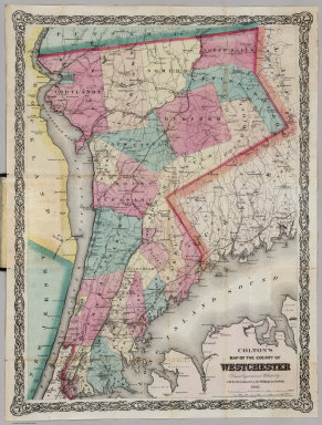
Author
Colton, G.W. & C.B.
Full Title
Colton's Map Of The County Of Westchester. Drawn, Engraved and Published by G.W. & C.B. Colton & Co. 172 William St. New York. 1867. Entered ... 1867 by G.W. & C.B Colton & Co. ... New York.
Publisher
G.W. & C.B Colton & Co.
Author
Poole Brothers
Full Title
Map Of The Mexican Central Railway And Connections. May, 1898.
Publisher
Poole Bros.
Author
Colton, G.W. & C.B.
Full Title
Colton's Railroad & Commercial Atlas Of The United States, Canada Etc. Map No. 5. Michigan, Wisconsin & Minnesota. Published by G.W. & C.B. Colton. & Co. New York, 1869.
Publisher
G.W. & C.B. Colton
Author
Colton, J.H.
Full Title
Colton's Map Of The Oil District Of West Virginia And Ohio. Published By J.H. Colton 172 William St. N.Y. 1865. Second Edition. Entered ... 1864 by J.H. Colton ... New York.
Publisher
J.H. Colton
Author
Colton, G.W. & C.B.
Full Title
Township Map Of The States Of New Hampshire And Vermont. Published by G.W. & C.B. Colton, & Co. New York, 1891.
Publisher
G.W. & C.B. Colton & Co.
Author
[Lea, I., Carey, H.C.]
Full Title
Pennsylvania.
Publisher
Carey & Lea
Author
Hardee, T.S.
Full Title
Hardee's Geographical, Historical and Statistical Official Map Of Mississippi Embracing Portions Of Alabama, Arkansas, Louisiana And Tennessee, From Recent Surveys And Investigations And Officially Compiled Under Authority From The State Legislature By T.S. Hardee State Engineer A.D. 1872. Hugh Lewis, Lithographer And Publisher - New Orleans, LA. Entered ... 1872 By T.S. Hardee ... At Washington. G. Koeckert. Engraver. (inset) Rail Road And Geological Map Of Mississippi. (inset) Profile of Grades New Orleans, Jackson And Great Northern Rail Road... (insets) Statistical tables and Historical information.
Publisher
Hugh Lewis
Author
Johnson, H.G.
Full Title
Johnson's New Map Of Niagara Falls And River. A Map Of Niagara River 4 Miles above and 3 below the Falls. By H.G. Johnson. Copyright Secured according to Act of Congress - 1849.
Publisher
H.G. Johnson
Author
Lester, William Jr.
Full Title
A Map Of Norwich, from actual Survey By William Lester Jr. Published By Thomas Robinson. 1833. Engraved & Printed By S. Stiles & Co. New York. (inset) View of a Part of Norwich City.
Publisher
Thomas Robinson
Author
Dutton, E.P.
Full Title
New Map Of Massachusetts Compiled from The latest and best Authorities. Published At The Boston Map Store, E.P. Dutton & Co. 135 Washington Street, Boston, 1866. Entered ... 1863 by E.P Dutton & Co ... Massachusetts. (inset) Salem. (inset) Springfield. (inset) Worchester. (inset) Lowell. (inset) Boston.
Publisher
E.P. Dutton
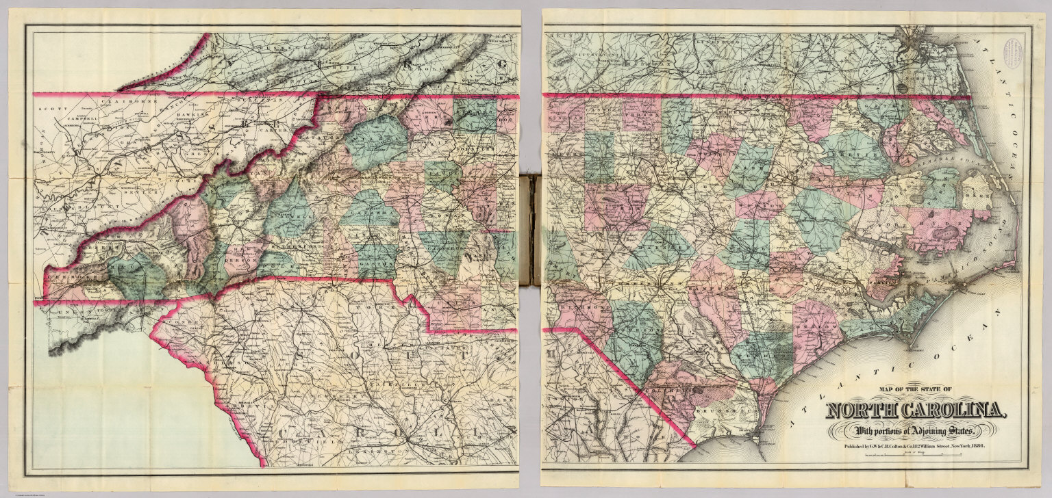
Author
Colton, G.W. & C.B.
Full Title
Map Of The State Of North Carolina, With Portions Of Adjoining States. Published by G.W. & C.B. Colton & Co. 182 William Street, New York, 1886.
Publisher
G.W. & C.B. Colton
Author
Lloyd, J.T.
Full Title
Lloyd's New Map of the United States The Canadas And New Brunswick From the latest Surveys Showing Every Railroad & Station Finished to June 1863 And The Atlantic And Gulf Coasts ... 1863 ... Address J.T. Lloyd, No. 164 Broadway, New York, and 1 Strand, London, England. Entered ... 1863, by J.T. Lloyd ... New York.
Publisher
J.T. Lloyd
Author
[Cram, George, Farrington, E.C.]
Full Title
Farrington's Map Of Maine, Together with the Index and Appendix Of Information ... E.C. Farrington, Augusta, Maine. (on verso) Index to State Map Of Maine. (with) Map Of The State Of Maine Showing Railroads, Towns, Plantations and Wild Lands. 1900. 61-63 Plymouth Place, Chicago, Ill. 130 Fulton Street, New York. Revised By Frank E. Oak, State Land Office, Augusta, Me. Copyright 1900 By E.C. Farrington, Augusta, Maine.
Publisher
E.C. Farrington
Author
Colton, G.W. & C.B.
Full Title
Colton's Map Of The Middle States Showing The Counties, Towns, Railroads, and Stations. Published By G.W. And C.B. Colton & Co. 172 William St. New York. 1874. Entered ... 1872 by G.W. & C.B. Colton & Co. ... Washington.
Publisher
G.W. & C.B. Colton
Author
Ohman, August R.
Full Title
Map Of The United States Showing Territorial Expansion Of A Century - 1804 To 1904. Designed and drawn for Judge Wm. T. Hall, Richmond, Me. by August R. Ohman 97-101 Warren Street, N.Y. Copyright, 1904, by August R. Ohman. (with 12 inset maps).
Publisher
A.R. Ohman
Author
Colton, G.W. & C.B.
Full Title
(Composite of) Map Of The State Of North Carolina, With Portions Of Adjoining States. Published by G.W. & C.B. Colton & Co. 182 William Street, New York, 1886.
Publisher
G.W. & C.B. Colton
Author
[Lloyd, H.H., Stebbins, Henry S.]
Full Title
(Covers to) New Map Of Ohio. Published By Henry S. Stebbins, Toledo Ohio. 1875. Entered ... 1866, by H.H. Lloyd & Co ... New York.
Publisher
[Henry s. Stabbins, Ingham & Bragg]
Author
[Eastwick, Morris & Co., Hanson, John]
Full Title
Map Of Puget Sound And Surroundings, Washington Territory. Compiled From Official Surveys And Published By Eastwick, Morris & Co. Civil & Mining Engineers Seattle, Wash. Ter. 1877. Drawn By John Hanson With Eastwick, Morris & Co. Seattle. W.T. Entered ... 1877 by Eastwick, Morris & Co. ... Washington. Lith. by A.M. Askevold, Ashland Block, Chicago.
Publisher
Eastwick, Morris & Co.
Author
Watson, Gaylord
Full Title
Watson's New Map Of The Western States, Territories, Mexico, And Central America. Published by Gaylord Watson, 16 Beekman Street, New York. Chicago: W.W. Wadsworth, 135 So. Water St. Entered ... 1869, by Gaylord Watson ... New York. (inset) Central America.
Publisher
W.W. Wadsworth
Author
Watson, Gaylord
Full Title
(Covers to) Watson's New Map Of The Western States, Territories, Mexico, And Central America. Published by Gaylord Watson, 16 Beekman Street, New York. Chicago: W.W. Wadsworth, 135 So. Water St. Entered ... 1869, by Gaylord Watson ... New York. (inset) Central America.
Publisher
W.W. Wadsworth
Author
Colton, J.H.
Full Title
J.H. Colton's Topographical Map of the Seat Of War In Virginia, Maryland, &c. J.H. Colton's Geographical Establishment No. 172 William St. New York. Entered ... 1862, by J.H. Colton ... New York. Printed By Lang & Cooper, 117 Fulton St. N.Y.
Publisher
J.H. Colton & Co.
Author
[Blanchard, Rufus, Morse, Charles W.]
Full Title
Morse's Map of Illinois. Published by Rufus Blanchard 52 La Salle St. Chicago. Entered ... 1854, by Rufus Blanchard ... New York. Taylor, Hoyt and Cook, Printers, 22 & 24 Frankfort-St., N.Y
Publisher
Rufus Blanchard
Author
Ensign, Bridgman & Fanning
Full Title
Map of Canada East And West. New York, Published by Ensign, Bridgman & Fanning. 156 William Street, 1855. Entered ... 1848 by Ensign's & Thayer ... New York. Printed by D. McLellan 26 Spruce St. N.Y. Entered ... 1853 by Ensign, Bridgman & Fanning ... New York. (untitled inset of Eastern Canada).
Publisher
Ensign Bridgman & Fanning.
Author
Colton, J.H.
Full Title
Colton's Railroad & Township Map of the State of Ohio. Published By J.H. Colton, No. 172 William St. New York. 1864. Entered ... 1851 by J.H. Colton ... New York.
Publisher
J.H. Colton
Author
Colton, G.W. & C.B.
Full Title
Colton's New Map of Missouri Compiled from the U.S. Surveys and other authentic sources. Published by G.W. And C.B. Colton, & Co. No. 172 William Street, New York, 1870. Entered ... 1851 by J.H. Colton ... N. York.
Publisher
G.W. & C.B. Colton & Co.
Author
Colton, G.W. & C.B. & Co.
Full Title
Colton's Dakota. Published By G.W. And C.B. Colton & Co. No. 182 William St. New York. 1886. Copy Right 1885 By G.W. & C.B. Colton & Co. N.Y.
Publisher
G.W. & C.B. Colton & Co.
Author
Colton, J.H.
Full Title
Colton's California 1861. Published By J.H. Colton, 172 William St. New York. York. Entered ... 1855 by J.H. Colton ... New York. (inset) City Of San Francisco.
Publisher
J.H. Colton
Author
Blanchard, Rufus
Full Title
(West half) Cabinet Map Of The United States And Territories On A Rectangular Projection Showing The Location Of Gold Silver And Other Minerals The Railroads And Principal Cities ... Compiled From Government Maps And Published By Rufus Blanchard. 146 Lake St. Chicago, Ill. 1868. Entered ... 1868, by R. Blanchard ... Ill. Engraved by Jerome T. Gouget, at R. Blanchard's Map Establishment ... Lith. Printing by Chas. Shober & Co. Chicago. (inset) A Map of The Western Part of the Territories belonging to the United States of America. (inset) Map Of The World Showing the Great Throughfare Between Europe & Asia Through the United States.
Publisher
Rufus Blanchard
Author
Blanchard, Rufus
Full Title
(East half) Cabinet Map Of The United States And Territories On A Rectangular Projection Showing The Location Of Gold Silver And Other Minerals The Railroads And Principal Cities ... Compiled From Government Maps And Published By Rufus Blanchard. 146 Lake St. Chicago, Ill. 1868. Entered ... 1868, by R. Blanchard ... Ill. Engraved by Jerome T. Gouget, at R. Blanchard's Map Establishment ... Lith. Printing by Chas. Shober & Co. Chicago. (inset) A Map of The Western Part of the Territories belonging to the United States of America. (inset) Map Of The World Showing the Great Throughfare Between Europe & Asia Through the United States.
Publisher
Rufus Blanchard
Author
Lapham, I.A.
Full Title
The State Of Wisconsin Compiled from the latest authorities And Published By I.A. Lapham, Milwaukee, Wis. 1854. Entered ... 1849 by Increase A. Lapham ... Wisconsin.
Publisher
I.A. Lapham
Author
Colton, G.W. & C.B. & Co.
Full Title
Map Of Staten Island Richmond County State Of New York. Prepared By G.W. & C.B. Colton & Co. 312 Broadway, New York. 1896. Entered ... 1884 by G.W. & C.B. Colton & Co. ... Washington.
Publisher
G.W. & C.B. Colton (312 Broadway).
Author
Norton, J.A.
Full Title
Railroad Map Of Ohio. Published By The State. 1890. Prepared By J.A. Norton, Commissioner of Railroads & Telegraphs. Columbus, Ohio. H.B. Stranahan & Co. Map Engravers & Publishers, Cleveland, Ohio. Copyright 1890 by H.B. Stranahan.
Publisher
State of Ohio
Author
Williams, A. & Co.
Full Title
A. Williams & Co. Railroad & Township Map Of Massachusetts. Published at the Boston Map Store. 283 Washington St. 1878. Entered ... 1876 by Cook and Ellis ... Washington D.C. Lith. by J. Mayer & Co. No 4 State St.
Publisher
The Boston Map Store
Author
Jocelyn, N. & S.S.
Full Title
Map Exhibiting the Farmington, & Hampshire & Hampden Canals, Together with the Line of their proposed continuation through the Valley of the Connecticut River, to Canada. Engraved and published by N. & S.S. Jocelyn. New Haven, 1828. Entered ... August 1st 1828 by N. & S.S. Jocelyn ... Connt. (inset) Profile of the Canals. Surveys furnished by Davis Hurd Esqr. Chief Engineer.
Publisher
N. & S.S. Jocelyn
Author
Colton, J.H.
Full Title
Colton's New Map of Missouri Compiled from the U.S. Surveys and other authentic sources. Published by J.H. Colton, No. 86 Cedar Street New York, 1854. Entered ... 1851 by J.H. Colton ... N. York. Drawn by Geo. W. Colton. Engraved by J.M. Atwood.
Publisher
J.H. Colton.
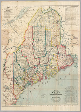
Author
Colton, G.W. & C.B.
Full Title
Colton's Maine. Published By G.W. And C.B. Colton & Co. No. 182 William St. New York. 1886. Copy Right 1885 By G.W. & C.B. Colton & Co. N.Y.
Publisher
G.W. & C.B. Colton
Author
Colton, G.W. & C.B.
Full Title
Colton's Maine. Published By G.W. And C.B. Colton & Co. No. 172 William St. New York. 1879. Entered ... 1855, by J.H. Colton & Co. ... New York.
Publisher
G.W. & C.B. Colton
Author
Dawson Brothers
Full Title
New Map Of The Dominion Of Canada. Dawson Brothers, Montreal. 1870. Engraved & Printed in Colours by J. Bartholomew, Edinburgh. (inset) Newfoundland. (inset) Environs Of Montreal.
Publisher
Dawson Brothers
Author
Willmer & Rogers
Full Title
Chart of The North & Baltic Seas &c. Showing the Lines of Steam Boat Communications, Soundings &c. Published by Willmer & Rogers Importers of Foreign Books & News Papers 42 & 44 Nassau Street New York. Lith & Print by Bevan & Boell, 163 Broadway N.Y. (inset) Harbour Of Heligoland. (inset) Port Of Revel. (inset) Harbour Of St. Petersburg.
Publisher
Willmer & Rogers
Author
Thayer, Horace & Co.
Full Title
Railroad & Township Map Of Ohio. Published By Horace Thayer & Co. 50 Ann St. New York. 1853. Entered ... 1851 by Ensign, Thayer & Co. ... New York. W.S. Barnard Sc. J. Wells Del.
Publisher
Horace Thayer & Co.
Author
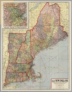
Kenyon Company
Full Title
Map of New England ... Copyright 1920 The Kenyon Company, Inc., Map Makers Des Moines, Iowa. Principal Automobile Highways Shown Thus ... (inset) Eastern Portion Of Massachusetts. (on verso) Index of New England States, With Official 1920 Census...
Publisher
The Kenyon Company, Inc.
Author
[Atwood, J.M., Thayer, Bridgman & Fanning]
Full Title
Map Of The United States, Canada, Mexico And The West Indies with Central America, Showing all the routes to California with a table of Distances. New York, Thayer, Bridgman & Fanning, 156, William St. cor. of Ann St. 1853. D. McLellan, Lithogr. 26 Spruce St. N.Y.
Publisher
Thayer, Bridgman & Fanning
Author
[Huntington, Eleazer, Andrus & Judd]
Full Title
An Ancient or Bible Map, Designed for the use of Bible Classes, Sunday Schools and Private Families. Compiled with much care and attention from the most authentic sources. Hartford. Published By Andrus & Judd. 1832. Entered ... 1831, by Eleazer Huntington ... Connecticut.
Publisher
Andrus & Judd
|