Who What Where WhenREMOVEWHO
WHEN
|
Author
Gill, Leslie MacDonald, 1884-1947
Full Title
Underground : Map of the electric railways of London. MacDonald Gill 1920. the Dangerfield Printing Co. LTD., London. (on verso : panel title) Underground : What to see & how to travel. Map of the electric railways of London. Electric Railway House, Broadway, Westminster, S.W. "1,000,000 9-3-21."
Publisher
The Dangerfield Printing Co.
Author
Chase, Ernest Dudley, 1878-1966
Full Title
Historic Massachusetts : a travel map to help you feel at home in the Bay State. Massachusetts. Department of Commerce, 334 Boylston St. Boston, 16 Mass. Designed and drawn by Ernest Dudley Chase. (on verso) A world of fun and relaxation, Massachusetts, the historic vacationland : a travel map to help you feel at home in the Bay State. "Form 97-150M-7-57-920616 Publication of the document approved by George J. Cronin, Staff purchasing agent".
Publisher
Dept. of Commerce
Author
Forest Lawn Memorial-Park Association
Full Title
Pictorial map of Forest Lawn Memorial - Park, showing the location of interment sections, buildings and art treasures. (on verso) Pictorial map of Forest Lawn Memorial-Park, Glendale, California. Copyrighted 1945 by Forest Lawn Memorial-Park Assn., Inc.
Publisher
Forest Lawn Assn., Inc.
Author
Mitchell, Samuel Augustus
Full Title
Map Of Mexico, Including Yucatan & Upper California, exhibiting The Chief Cities and Towns, The Principal Travelling Routes &c. Philadelphia: Published by S. Augustus Mitchell N.E. Corner Of Market And Seventh Sts. 1847. Entered ... 1846 by S. Augustus Mitchell ... Pennsylvania. (inset) The Late Battlefield.
Publisher
S.A. Mitchell
Author
[Mallery, J.C., Ward, J.W.]
Full Title
New Map Of The Territory Of Arizona, Southern California And Parts Of Nevada, Utah And Sonora. Compiled from the latest authentic data by Lieut. J.C. Mallery, A.M., U.S. Engineer Corps, and J.W. Ward, Civil & Topographical Engineer. 1876. 1877. Office 105 Stockton St. San Francisco. Payot, Upman & Company, Publishers and Wholesale Stationers, 204 Sansome Street, (near Pine) San Francisco. Britton, Rey & Co. Lithrs. S.F. Entered ... 1876, by Lieut. J.C. Mallery & J.W. Ward ... Washington. (with 3 inset profiles) Geological Sections From The Verde River To The Gila River, Arizona Ter ...
Publisher
Payot, Upham & Company
Author
[Mitchell, Samuel Augustus, Stealey, Geo.]
Full Title
Map Of Mexico, Including Yucatan & Upper California, exhibiting The Chief Cities and Towns, The Principal Travelling Routes &c. Philadelphia: Published by S. Augustus Mitchell N.E. Corner Of Market And Seventh Sts. 1847. Entered ... 1847 by S. Augustus Mitchell ... Pennsylvania. (inset) The Late Battlefield. (with) Map of the Principal Roads from Vera Cruz and Alvarado to the City of Mexico ... Compiled from the latest and best Authorities. By Geo. Stealey, Civil Engineer.
Publisher
S.A. Mitchell
Author
[Doolittle, A.J., Holt, A.J., Ransom, Leander]
Full Title
New Map Of The State Of California And Nevada Territory Exhibiting the Rivers, Lakes, Bays and Islands, with the principal Towns, Roads, Railroads and Transit Routes to the Silver Mining Districts of Nevada Territory ... Carefully compiled from United States and other Reliable Surveys by Leander Ransom. A.J. Doolittle, 1863. ... Entered ... 1863 by Warren Holt ... California. Lith. by L. Nagel, 529 Clay St. San Francisco.
Publisher
Warren Holt
Author
Hale, Nathan
Full Title
A Map of the New England States, Maine, New Hampshire, Vermont, Massachusetts, Rhode Island & Connecticut, With the adjacent parts of New York & Lower Canada. Compiled and Published By Nathan Hale, Boston 1826. Engraved by J.V.N. Throop. Revised Edition of 1853. Corrected by the addition of the Railroads, new towns, & other public improvements, to Feby. 1853. Entered ... February 1853, by Nathan Hale ... Massachusetts. (inset) Northern & Eastern Part Of Maine And Part Of Lower Canada And New Brunswick. With Corrections in 1853.
Publisher
Nathan Hale
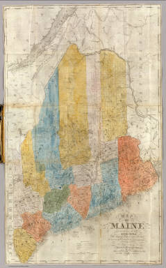
Author
Colton, J. H.
Full Title
Maine. 1853. Published By J.H. Colton. No. 86 Cedar St. New York. Entered ... 1853, by J.H. Colton ... New York.
Publisher
J.H. Colton
Author
Desilver, Charles
Full Title
A New Map of Maine. Published By Charles DeSilver No. 251 Market Street Philadelphia. 1857. Entered ... 1856 by Charles Desilver ... Pennsylvania.
Publisher
Charles Desilver
Author
Rand McNally and Company
Full Title
Rand, McNally & Co's. New Commercial Railroad Map Of The United States With Portions Of The Dominion Of Canada, The Republic Of Mexico, And The West Indies. Compiled from the most reliable sources, and engraved by Rand, McNally & Co., Map Engravers and Publishers, 160-174 Adams Street, Chicago, Ill. 1907.
Publisher
Rand McNally & Co.
Author
[Colton, G. W. & C. B., Swann, John S.]
Full Title
Title Map of the Coal Field Of The Great Kanawha Valley West Virginia, United States of America. By John S. Swann, Attorney at Law, Charleston, Kanawha County W. Va. Engraved, Printed, And Manufactured By G.W. & C.B. Colton & Co. No. 172 Williams St New York. Price of Map $10.00 To Be Procured Of Thomas L. Broun ... and John S. Swann ... Entered ... 1867, by John S. Swann ... Charleston, West Virginia. (inset) West Virginia Showing the rail and water communication Between The Great Kanawha District And Pittsburgh & Cincinnati.
Publisher
G.W. & C.B. Colton
Author
Judson, L.
Full Title
(Covers to) Iowa. A sectional Map of the Black Hawk Purchase with a part of Illinois And Wisconsin. By L. Judson. Engd. by Doolittle & Munson Cini. Entered ... 1838, by L. Judson ... Ohio.
Publisher
Doolittle & Munson
Author
Judson, L.
Full Title
Iowa. A sectional Map of the Black Hawk Purchase with a part of Illinois And Wisconsin. By L. Judson. Engd. by Doolittle & Munson Cini. Entered ... 1838, by L. Judson ... Ohio.
Publisher
Doolittle & Munson
Author
[Ebert, Frederick J., Gilpin, William, 1822-1894, Monk, Jacob]
Full Title
Map Of Colorado Territory, Shewing The System Of Parks. Drawn by Frederick J. Ebert under direction of the Governor Wm. Gilpin. Published by Jacob Monk, Philadelphia, Pa. 1865. Thos. Sinclair's lith. Philada.
Publisher
Jacob Monk
Author
Paul, Rene
Full Title
Map Of The City Of St. Louis Compiled from information in the possession of Rene Paul Esqr. 1844. Published By Twichel & Cook N.W. Cor. Main & Pine Sts. St. Louis Mo. Engraved at the Office of J.T. Hammond, By T. Twichel. N.W. Cor. Main & Pine Streets. St. Louis Mo.
Publisher
[Engraved at the office of J.T. Hammond, by T. Twichel., Twichel & Cook]
Author
Tennent, Thomas
Full Title
Map Of Lower Oregon and Upper California from the latest and Most Authentic Surveys Published by Thomas Tennent, at the Surveying & Navigation Warehouse Sign of "The Wooden Sailor." San Francisco. 1853. California. Lith. by Alex: Zakreski Cor. Washington & Monty. Entered ... 1853, by Thomas Tennent ... California.
Publisher
Thomas Tennent
Author
Adams, George H. & Son
Full Title
Geo. H. Adams & Son Colorado. Copyright 1884, By Geo. H. Adams & Son, New York.
Publisher
George H. Adams & Son.
Author
[Alaska Exploration Company, Davidson, George]
Full Title
Map Showing Routes From San Francisco To Alaska And The Klondike. The Alaska Exploration Company, General Offices: Liebes' Building, 139 Post Street, San Francisco, Cal., U.S.A. 29 Queen Street, London, Eng. ... This map was compiled by Prof. Geo. Davidson, late Asst. Supt. U.S. Coast & Geodetic Survey. Copyright 1897. Dakin Pub. Co. Maps 320 Sansome St. S.F. (inset) Map Of The Klondike.
Publisher
The Alaska Exploration Company
Author
American Telephone and Telegraph Company
Full Title
Lines And Metallic Circuit Connections. American Telephone and Telegraph Company. 15 Dey St., New York September 1898. (inset) Maine.
Publisher
No Publisher
Author
American Telephone and Telegraph Company
Full Title
Lines and Metallic Circuit Connections. American Telephone and Telegraph Co. 18 Cortlandt St. New York. March 1, 1891.
Publisher
No Publisher
Author
Andriveau-Goujon, E.
Full Title
Carte Generale Des Etats - Unis Et Du Mexique Comprenant L'Amerique Centrale Et Les Antilles. E. Andriveau-Goujon, Editeur. Paris, Rue Du Bac, 21. 1865 ... (with four inset maps).
Publisher
Andriveau-Goujon
Author
Anson, W.
Full Title
Map Of Maine Constructed from the most Correct Surveys With Sectional Distances and Elevations or Level, of the St. Croix River from Calais Bridge. Deduced from the States Survey, Made by W. Anson, Civil Engineer, In 1836. Engraved & Published by by S.H. Colesworthy, Portland. 1843. Revised Edition.
Publisher
S.H. Colesworthy
Author
[Asher & Company, Russell, Benjamin B.]
Full Title
The Historical War Map. Asher & Co. Entered ... 1862, by Asher & Co. ... Indiana. E.R. Jewett & Co. Engravers, Buffalo, N.Y.
Publisher
Benjamin B. Russell
Author
Atwood, J.M.
Full Title
Map Of The United States, Canada, Mexico, Central America, and the West India Islands With a Portion of Venezuela & New Granada; Showing the routes overland and by the Isthmus to California and Oregon, Also the new Boundaries of California, Utah, & New Mexico, Compiled from the latest Authorities. Engraved & Published By J.M. Atwood, No. 19 Beekman Street, New York. 1851. D. McLellan, Printr. Spruce St ... Entered ... 1851, by J.M. Atwood ... New York.
Publisher
J.M. Atwood
Author
Bancroft, A.L.
Full Title
Bancroft's Official Guide Map Of City And County Of San Francisco, Compiled From Official Maps In Surveyor's Office. Published by A.L. Bancroft & Co. ... San Francisco, 1873. Entered ... 1873, by A.L. Bancroft & Company ... Washington, D.C. (inset) Skeleton Map Showing the relative position of San Francisco to the Surrounding Country.
Publisher
A.L. Bancroft
Author
[Bancroft, A.L., Knight, W.H.]
Full Title
Bancroft's New Map Of Central California Compiled by Wm. Henry Knight. San Francisco, A.L. Bancroft & Company. 1871.
Publisher
A.L. Bancroft
Author
Bancroft, H.H.
Full Title
Bancroft's Map Of California, Nevada, Utah And Arizona. Published By H.H. Bancroft, & Compy. Booksellers & Stationers San Francisco Cal. 1864. Entered ... 1863, by H.H. Bancroft & Company ... California.
Publisher
H.H. Bancroft & Company.
Author
Bancroft, H.H.
Full Title
Bancroft's Map Of Oregon, Washington, Idaho, Montana And British Columbia. Published By A.L. Bancroft, & Compy. Booksellers & Stationers San Francisco, Cal. 1872. Entered ... 1872 by A.L. Bancroft & Co. ... Washington D.C.
Publisher
A.L. Bancroft
Author
Barber, John Warner
Full Title
Map Of The United States exhibiting the principal Rail Road & Steam boat Routes.
Publisher
J.W. Barber
Author
[United States. Post Office Dept., Von Haake, A.]
Full Title
Post Route Map Of The States Of Kentucky And Tennessee With Adjacent Parts Of Va., West Va., Ohio, Ind., Ill., Mo., Ark., Miss., Ala., Ga., S.C., N.C. ... Published By Order Of Postmaster General Wilson S. Bissell Under The Direction Of A. Von Haake, Topographer P.O Dept. (seal) Post Office Department. United States Of America With Celerity, Certainty And Security. (inset) Environs Of Louisville, Ky.
Publisher
U.S. Post Office
Author
[Mitchell, Samuel Augustus, Young, James H.]
Full Title
Mitchell's Travellers Guide Through The United States. A Map Of The Roads, Distances, Steam Boat & Canal Routes &c. By J.H. Young. Philadelphia. Published by S. Augustus Mitchell. 1832. Engraved On Steel By J.H. Young And D. Haines. Entered ... 1832, by S. Augustus Mitchell ... Pennsylvania. (with 9 inset maps).
Publisher
S.A. Mitchell
Author
Monk, Jacob
Full Title
Map Of The Seat Of War Exhibiting The Surrounding Country, The Approaches By Sea & Land To The Capital Of The United States And The Military Posts, Forts, &c. Published by Jacob Monk, Philadelphia. 1861. T. Sinclair's Lith, Phila.
Publisher
Jacob Monk
Author
Security Savings Bank
Full Title
Map of Beaches and nearby Points of Interest. Copyright 1908 by Security Savings Bank Los Angeles, California ... Presented Free With Compliments Of Security Savings Bank. Security Bldg. Spring And Fifth Sts. (inset) Extension Of Hollywood. (inset) Extension Of Garvanza South Pasadena. (inset) Map Showing The "Shoestring" Annexed to the City of Los Angeles. (on verso, map of the Vicinity of Los Angeles) Security Map 1907. (on verso) Depot Lines.
Publisher
Security Savings Bank
Author
Lloyd, J. T.
Full Title
Lloyd's official map of the State of Virginia from actual surveys by order of the Executive 1828 & 1859. Corrected and revised by J.T. Lloyd to 1862, from surveys made by Capt. W. Angelo Powell, of the U.S. Topographical Engineers of Gen. Rosencrans' Staff. Price 25cts. ... J.T. Lloyd, Publisher, 164 Broadway, New York ... Entered ... 1861 by J.T. Lloyd ... New York.
Publisher
J.T. Lloyd
Author
Ludwig, Pablo
Full Title
Nuevo mapa de la Republica Argentina, Chile, Uruguay y Paraguay construido y publicado por la Oficina Cartografica de Pablo Ludwig segun los datos mas recientes. Buenos Aires,1914. Gunche, Wiebeck y Turtl-O'Brien 121, Bs. As. (with) Alrededores de Buenos Aires.
Publisher
Pablo Ludwig.
Author
Ludwig, Pablo
Full Title
Ciudad de Buenos-Aires y Distrito Federal publicado por Pablo Ludwig, Cartografo Segun los datos oficiales y observaciones propias. 1892. Es propiedad del editor. Compilado, dibujado y grabado por Pablo Ludwig, Buenos Aires. Imp. Est. Grafico de Gunche, Wiebeck y Turtl. San Martin 315 Bs. A ... (with) Parque de Palermo. (with) Isla de Martin Garcia.
Publisher
Pablo Ludwig.
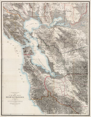
Author
[Hoffmann, Charles F., Whitney, J.D., Geological Survey of California]
Full Title
(North Sheet) State Geological Survey Of California. J.D. Whitney, State Geologist. Map Of The Region Adjacent To The Bay Of San Francisco. 1873. The Coast, Rancho, Township and Section Lines from Materials furnished by the U.S. Coast Survey and the U.S. Surveyor General's Office, the Topography chiefly from Original Surveys by C.F. Hoffman ... Julius Bien, Lith.
Publisher
Julius Bien
Author
[Hoffmann, Charles F., Whitney, J.D., Geological Survey of California]
Full Title
(South Sheet) State Geological Survey Of California. J.D. Whitney, State Geologist. Map Of The Region Adjacent To The Bay Of San Francisco. 1873. The Coast, Rancho, Township and Section Lines from Materials furnished by the U.S. Coast Survey and the U.S. Surveyor General's Office, the Topography chiefly from Original Surveys by C.F. Hoffman ... Julius Bien, Lith.
Publisher
Julius Bien
Author
[Hoffmann, Charles F., Whitney, J.D., Geological Survey of California]
Full Title
(Composite) State Geological Survey Of California. J.D. Whitney, State Geologist. Map Of The Region Adjacent To The Bay Of San Francisco. 1873. The Coast, Rancho, Township and Section Lines from Materials furnished by the U.S. Coast Survey and the U.S. Surveyor General's Office, the Topography chiefly from Original Surveys by C.F. Hoffman ... Julius Bien, Lith.
Publisher
Julius Bien
Author
Rand McNally and Company
Full Title
Rand, McNally & Co.'s new geological map of Colorado. Copyright, 1879, by Rand, McNally & Co.
Publisher
Rand McNally & Co.
Author
Smith, J. Calvin
Full Title
Map of North America by J. Calvin Smith. Published by J. Disturnell. New York, 1852. (with) Map of the Gold Region, California.
Publisher
J. Disturnell
Author
Vincent
Full Title
Map Of The State Of California. Compiled from the most recent surveys and explorations Containing all the latest discoveries and newest towns. By Vincent. Printed by Mangeon S. Jacques St. Engraved by Ch. Smith. (inset) San Francisco and its surrounding localities. 1860.
Publisher
Mangeon
Author
Root, R.C., Anthony & Co.
Full Title
(Covers to) Map Of The Oil District Venango, Crawford & Warren Counties, Pennsylvania. 1864. Published by R.C. Root, Anthony & Co. 16 Nassau St. N.Y.
Publisher
R.C. Root, Anthony & Co.
Author
[Bielawski, C., Hoffman, Hoffmann, J.D., Poett, A.]
Full Title
(Covers to) Topographical And Railroad Map of the Central Part of the State of California, and Part of the State Of Nevada. 1865. Compiled from Railroad Surveys, U.S. Public Land Surveys, U.S. Coast Surveys, California State Geological Survey (Prof. J.D. Whitney), and from reliable private Surveys, and Published by C. Bielawski, J.D. Hoffmann & A. Poett, Civil Engineers & Survrs. Britton & Co. Lith: San Francisco. Entered ... 1865 by J.D. Hoffmann & A. Poett ... California.
Publisher
Britton & Co. Lith.
Author
Blanchard, Rufus
Full Title
(Covers to) Map Of Chicago. Rufus Blanchard, 52 La Salle Street. 1857.
Publisher
R. Blanchard
Author
Blanchard, Rufus
Full Title
(Covers to) Map Of Chicago And Environs. Compiled And Published By Rufus Blanchard, Chicago, 146 Lake St. Illinois. 1869. (with) Guide Map of Chicago. Published by Rufus Blanchard, 146 Lake St. 1868. Lith. Chas. Shober & Co. (with) Citizen's Guide For The City of Chicago. Companion to Blanchard's Map of Chicago. Published By Rufus Blanchard, 146 Lake Street, Chicago.
Publisher
Rufus Blanchard
Author
Holt, George L.
Full Title
(Covers to) Holt's New Map Of Wyoming. Compiled by permission from official records in U.S. Land Office. Published by G.L. Holt, Cheyenne, Wyo. Frank & Fred Bond, Draftsmen. 1885. Entered ... 1883 by Geo L. Holt ... Washington D.C. Engraved & Printed by G.W. & C.B. Colton & Co. New York.
Publisher
G.L. Holt
Author
Hooker, William
Full Title
(Covers to) Hooker's New Pocket Plan Of The City Of New York. Compiled & Surveyed By William Hooker, ACSA Hydrographer & Engraver. New York: Drawn, Engraved, Printed, Published & Sold by W. Hooker ... 1828. Additions to 1829 ... Entered ... 27th day of March 1824 ... N. York.
Publisher
William Hooker
Author
[Bruff, J. Goldsborough, Disturnell, John]
Full Title
(Covers to) A Correct Map Of The Seat Of War In Mexico. Being a Copy of Genl. Arista's Map, taken at Resaca de la Palma, with additions and Corrections ... New York: Published By J. Disturnell. 102, Broadway, 1847. Designed by J.G. Bruff Washington D.C. Entered ... 1847, by J.G. Bruff ... New York. Lith. of E. Jones & G.W. Newman, 128, Fulton St. On Stone by J. Probst. (with 4 inset maps).
Publisher
J. Disturnell
|