Who What Where WhenWHAT
WHEREShow More |
REFINE
Browse All : Political and Physical
1-34 of 34
Author
[Bayer, Herbert, Container Corporation of America]
Full Title
Europe Physical.
Publisher
Container Corporation of America
Author
Woodbridge, William C.
Full Title
Physical And Political Map Of The N. Eastern States. Adapted To Woodbridge's Geography. Drawn & Engd. by Story & Atwood. N. York. Entered .. . 1843, by W.C. Woodbridge ... Massachusetts. Hartford. Published By Wm. Jas. Hamersley.
Publisher
Wm. Jas. Hamersley
Author
Woodbridge, William C.
Full Title
Physical & Political Map Of The Southern Division Of the United States. Adapted To Woodbridge's Geography. Entered .. . 1843, by W.C. Woodbridge ... Massachusetts. Hartford. Published By Wm. Jas. Hamersley. (inset map) Vicinity of Charleston. (inset map) Vicinity of New Orleans.
Publisher
Wm. Jas. Hamersley
Author
Woodbridge, William C.
Full Title
(Title Page to) Modern Atlas, Physical, Political And Statistical; Exhibiting On Separate Maps, The Physical And Political Characteristics Of Countries, The Prevailing Religions, Forms Of Government And Degrees Of Civilization, The Climates And Productions Of The Earth, And The Comparative Size Of Countries, Towns, Rivers And Mountains; Accompanied By Geographical And Statistical Tables. By William C. Woodbridge ... Entered ... 1843, by W.C. Woodbridge ... Massachusetts. Hartford. Published By Belknap And Hamersley.
Publisher
Belknap and Hamersley
Author
Rand McNally
Full Title
Physical/Political Europe.
Publisher
Rand McNally
Author
Rand McNally
Full Title
Physical/Political North America.
Publisher
Rand McNally
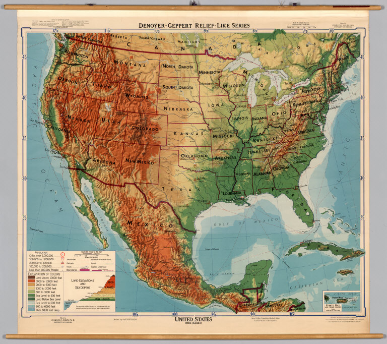
Author
[Colby, Charles C., Wenschow]
Full Title
United States with Mexico.
Publisher
Denoyer-Geppert Company
Author
Jones, Clarence F.
Full Title
Caribbean Area.
Publisher
Denoyer-Geppert Company
Author
Instituto Geografico National
Full Title
Mapa Fisico Politico Vial - Peru.
Publisher
Instituto Geografico National
Author
Klett-Perthes
Full Title
Asia. Political
Publisher
Justus Perthes Verlag Gotha GmbH
Author
Klett-Perthes
Full Title
Asia. Physical.
Publisher
Justus Perthes Verlag Gotha GmbH
Author
[Rothaug, J.G., Umlauft, Friedrich, Freytag & Berndt]
Full Title
Schulwandkarte der Ostlichen Erdhalfte.
Publisher
Freytag & Berndt
Author
Hassinger, H.
Full Title
Freytag & Berndts Wandkart von Mittle-Europa.
Publisher
Kartogr. Anst. G. Freytag & Berndt A.G.
Author
[Klett Perthes, Haack Gotha]
Full Title
South Asia.
Publisher
Klett Perthes
Author
George Philip & Son, Ltd.
Full Title
Philip's Regional Wall Map of China.
Publisher
The London Geographical Institute
Author
Ginsburg, Norton
Full Title
Southeast Asia.
Publisher
Denoyer-Geppert Company
Author
[Justus Perthes, Painke, Haack]
Full Title
Japan and Korea.
Publisher
Justus Perthes
Author
The London Geographical Institute
Full Title
Dominion of New Zealand.
Publisher
George Philip & Son, Ltd.
Author
Wenschow - Franzis, Karl
Full Title
Africa, Wenschow Relief-Like Map.
Publisher
Rand McNally Co.
Author
Klett-Perthes
Full Title
Africa.
Publisher
Justus Perthes Verlag Gotha GmbH
Author
[Justus Perthes, Haack]
Full Title
Naher Osten.
Publisher
Justus Perthes
Author
Paul List Verlag
Full Title
Vorderasien - Arabien.
Publisher
Wenschow - Reliefkarte
Author
[Haack-Painke, Riede, H.]
Full Title
Israel und Seine Arabischen Nachbarn.
Publisher
Justus Perthes Darmstadt
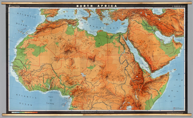
Author
[Haack, Hermann, Perit, H., Peuckert, H., Anstalt Gotha]
Full Title
North Africa.
Publisher
Haack/Gotha
Author
[Denoyer-Geppert Company, London Geographical Institute, Georg Philip & Son]
Full Title
East Africa, Philips' Regional Wall Map of....
Publisher
Georg Philip & Son
Author
Denoyer-Geppert Company
Full Title
Sectional Map of the United States, Southwestern/Northwestern United States.
Publisher
Denoyer-Geppert Company
Author
[Smith, Ronald, Babcock, Chester]
Full Title
Pacific Northwest.
Publisher
AJ Nystrom & Co
Author
Fairbanks, Harold W.
Full Title
Natural Environment Physical Political Map California.
Publisher
A.J. Nystrom & Co.
Author
[Denoyer, L.P., Blair, R. Baxter]
Full Title
Iowa, Physical and Political.
Publisher
Denoyer-Geppert Company
Author
[Götz, Antonín, Československá akademie věd., Czechoslovakia. Ústřední správa geodézie a kartografie.]
Full Title
(Czechoslovakia in Europe).
Publisher
Czechoslovakia. Ústřední správa geodézie a kartografie.
Author
[Götz, Antonín, Československá akademie věd., Czechoslovakia. Ústřední správa geodézie a kartografie.]
Full Title
Prehledna Mapa. (General Map).
Publisher
Czechoslovakia. Ústřední správa geodézie a kartografie.
Author
[Tardieu, P.F., Tardieu, P. (Pierre Antoine), 1784-1869]
Full Title
(Composite of) A Map of Louisiana and Mexico. Carte de la Louisiane et du Mexique, Dressee par P. Tardieu fils aine, Gravee par P.A.F. Tardieu pere. Paris 1820. A Paris, chez: P.A.F. Tardieu, Place de l'Estrapade No. 34. C. Piequet, Geographe Graveur, Quai Conti No. 17. J. Goujon, Marchand de Cartes Geographiques, Rue du Bac No. 6. New York. Anthy. Girard , Mercht. Agent for the Author. Ecrit par Richomme.
Publisher
J. (Jean) Goujon, 1793-1826
Author
[Tardieu, P.F., Tardieu, P. (Pierre Antoine), 1784-1869]
Full Title
A Map of Louisiana and Mexico (northern portion). Carte de la Louisiane et du Mexique, Dressee par P. Tardieu fils aine, Gravee par P.A.F. Tardieu pere. Paris 1820. A Paris, chez: P.A.F. Tardieu, Place de l'Estrapade No. 34. C. Piequet, Geographe Graveur, Quai Conti No. 17. J. Goujon, Marchand de Cartes Geographiques, Rue du Bac No. 6. New York. Anthy. Girard , Mercht. Agent for the Author. Ecrit par Richomme.
Publisher
J. (Jean) Goujon, 1793-1826
Author
[Tardieu, P.F., Tardieu, P. (Pierre Antoine), 1784-1869]
Full Title
A Map of Louisiana and Mexico (southern portion). Carte de la Louisiane et du Mexique, Dressee par P. Tardieu fils aine, Gravee par P.A.F. Tardieu pere. Paris 1820. A Paris, chez: P.A.F. Tardieu, Place de l'Estrapade No. 34. C. Piequet, Geographe Graveur, Quai Conti No. 17. J. Goujon, Marchand de Cartes Geographiques, Rue du Bac No. 6. New York. Anthy. Girard , Mercht. Agent for the Author. Ecrit par Richomme.
Publisher
J. (Jean) Goujon, 1793-1826
1-34 of 34
|