Browse All

1876 Plate F. Parts of Wards 3 & 4, Newport, … City Atlas Plate F. Parts of Wards 3 & 4, Newport. |

1876 Plate G. Parts of Wards 2 & 3, Newport, … City Atlas Plate G. Parts of Wards 2 & 3, Newport. |

1876 Plate H. Parts of Wards 2 & 3, Newport, … City Atlas Plate H. Parts of Wards 2 & 3, Newport. |

1876 Plate I. Part of Ward 2, Newport, Rhode … City Atlas Plate I. Part of Ward 2, Newport. |

1876 Plate J. Parts of Wards 1 & 2, Newport, … City Atlas Plate J. Parts of Wards 1 & 2, Newport. |

1876 Plate K. Parts of Wards 1 & 2, Newport, … City Atlas Plate K. Parts of Wards 1 & 2, Newport. |

1876 Plate L. Parts of Wards 1 & 2, Newport, … City Atlas Plate L. Parts of Wards 1 & 2, Newport. |

1876 Plate M. Parts of Wards 1 & 2, Newport, … City Atlas Plate M. Parts of Wards 1 & 2, Newport. |

1876 Plate N. Part of Ward 2, Newport, Rhode … City Atlas Plate N. Part of Ward 2, Newport. |

1876 Plate O. Part of Ward 2, Newport, Rhode … City Atlas Plate O. Part of Ward 2, Newport. |

1876 Plate P. Parts of Wards 2, 3, & 4, Newpo … City Atlas Plate P. Parts of Wards 2, 3, & 4, Newpo … |

1876 Plate Q. Part of Ward 5, Newport, Rhode … City Atlas Plate Q. Part of Ward 5, Newportg. |

1876 Plate R. Part of Ward 5, Newport, Rhode … City Atlas Plate R. Part of Ward 5, Newport. |

1876 Plate S. Part of Ward 5, Newport, Rhode … City Atlas Plate S. Part of Ward 5, Newport. |

1876 Plate T. Part of Ward 5, Newport, Rhode … City Atlas Plate T. Part of Ward 5, Newport. |

1876 Plate U. Part of Ward 5, Newport, Rhode … City Atlas Plate U. Part of Ward 5, Newport. |

1876 Plate V. Part of Ward 5, Newport, Rhode … City Atlas Plate V. Part of Ward 5, Newport. |

1876 Plate W. Part of Ward 5, Newport, Rhode … City Atlas Plate W. Part of Ward 5, Newport. |

1876 Plate X. Part of Ward 5, Newport, Rhode … City Atlas Plate X. Part of Ward 5, Newport. (inset … |

1874 Put-In-Bay Island, Ottawa County (Ohio). County Atlas Put-In-Bay Island. |

1874 Middle Bass Island, Ottawa County, Ohio. County Atlas Middle Bass Island. |

1874 North Bass Island, Ottawa County, Ohio. County Atlas North Bass Island. |

1874 Ottawa City. Catawba Island, Ottawa Coun … County Atlas Ottawa City. Catawba Island. |

1874 Danbury, Ottawa County, Ohio. County Atlas Danbury, O. |

1874 Portage, Ottawa County, Ohio. Port Clint … County Atlas Portage. Port Clinton, O. |

1874 Bay, Ottawa County, Ohio. County Atlas Bay, Ottawa County, Ohio. |

1874 Erie, Ottawa County, Ohio. Carroll. County Atlas Erie. Carroll. |

1874 Carroll, Ottawa County, Ohio. County Atlas Carroll, Ottawa County, Ohio. |

1874 Salem, Ottawa County, Ohio. County Atlas Salem. |

1874 Oak Harbor, Ohio. County Atlas Oak Harbor. |

1874 Harris, Ottawa County, Ohio. County Atlas Harris. |

1874 Elmore, Ohio. County Atlas Elmore, O. |

1874 Benton, Ottawa County, Ohio. County Atlas Benton. |

1874 Middleton. Elliston. Sheldon, Ohio. County Atlas Middleton. Elliston. Sheldon. |

1874 Clay, Ottawa County, Ohio. County Atlas Clay. |

1874 Genoa, Ohio. County Atlas Genoa. |

1874 Martin. Clay Centre, Ohio. County Atlas Martin O. Clay Centre. |

1874 South Shore Division of Put-in-Bay, Otta … County Atlas South Shore Division of Put-in-Bay. |

1872 Ursa and Mendon Townships, Adams County, … County Atlas Map of Ursa Township. Map of Mendon Town … |

1872 Burton Township, Adams County, Illinois. County Atlas Map of Burton Township. |
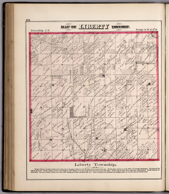
1872 View: Liberty Township, Adams County, Il … County Atlas (View) Map of Liberty Township. |

1872 McKee Township, Adams County, Illinois. County Atlas Map of McKee Township. |

1872 Beverly Township, Adams County, Illinois … County Atlas Map of Beverly Township. |

1872 Richfield Township, Adams County, Illino … County Atlas Map of Richfield Township. |

1872 Payson Township, Adams County, Illinois. County Atlas Map of Payson Township. |

1872 Payson. Keokuk Junction. Fowler, Illinoi … County Atlas Map of Payson. Map of Keokuk Junction. M … |

1872 Coatsburg. Houston. Paloma. Lima, Illino … County Atlas Map of Coatsburg. Map of Houston. Map of … |
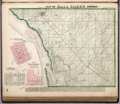
1872 Fall Creek Township, Adams County, Illin … County Atlas Map of Fall Creek Township. Map of Millv … |

1877 Miami County, Indiana. County Atlas Map of Miami County. |

1877 City of Peru, Indiana. County Atlas Map of the City of Peru, Drawn And Compi … |