Browse All

1895 Plat of Mineral, Missouri. County Atlas Plat of Mineral. |

1895 Oronogo, Originally Minersville, Missour … County Atlas Oronogo, Originally Minersville. |

1895 Plat of McDonald, Missouri. County Atlas Plat of McDonald. |

1895 Avilla, Missouri. County Atlas Avilla. |

1895 Plat of Preston, Missouri. County Atlas Plat of Preston. |

1895 Preston, Brest P.O. Carytown, Originally … County Atlas Preston, Brest P.O. Carytown, Originally … |

1895 Jasper, Missouri. County Atlas Jasper. |

1895 Plat of Sarcoxie, Missouri. County Atlas Plat of Sarcoxie. |

1895 Reeds, Missouri. County Atlas Reeds. |

1895 West Part of Sarcoxie, Missouri. County Atlas West Part of Sarcoxie. |

1895 Plat of Sheridan, Missouri. County Atlas Plat of Sheridan. |

1895 Plat of Twin Groves, Missouri. County Atlas Plat of Twin Groves. |

1895 East Part of Sarcoxie. County Atlas East Part of Sarcoxie. |

1895 Waco, Missouri. County Atlas Waco. |

1895 Smithfield, Missouri. County Atlas Smithfield. |

1895 West Part of Carl Junction. County Atlas West Part of Carl Junction. |

1895 Plat of Union, Missouri. County Atlas Plat of Union. |

1895 East Part of Carl Junction, Missouri. County Atlas East Part of Carl Junction. |

1899 Hubbard, Trumbull County, Ohio. County Atlas Map of Hubbard. |

1899 Brookfield, Trumbull County, Ohio. County Atlas Map of Brookfield. |

1899 Hartford, Trumbull County, Ohio. County Atlas Map of Hartford. |

1899 Vernon, Trumbull County, Ohio. County Atlas Map of Vernon. |

1899 Kinsman, Trumbull County, Ohio. County Atlas Map of Kinsman. |

1899 Liberty, Trumbull County, Ohio. County Atlas Map of Liberty. |
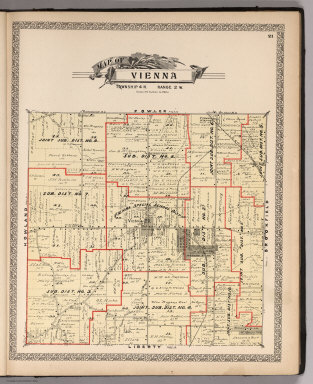
1899 Vienna, Trumbull County, Ohio. County Atlas Map of Vienna. |

1899 Fowler, Trumbull County, Ohio. County Atlas Map of Fowler. |

1899 Johnston, Trumbull County, Ohio. County Atlas Map of Johnston. |

1899 Gustavus, Trumbull County, Ohio. County Atlas Map of Gustavus. |

1899 Weathersfield, Trumbull County, Ohio. County Atlas Map of Weathersfield. |

1899 Howland, Trumbull County, Ohio. County Atlas Map of Howland. |

1899 Bazetta, Trumbull County, Ohio. County Atlas Map of Bazetta. |

1899 Mecca, Trumbull County, Ohio. County Atlas Map of Mecca. |

1899 Greene, Trumbull County, Ohio. County Atlas Map of Greene. |

1899 Lordstown, Trumbull County, Ohio. County Atlas Map of Lordstown. |

1899 Warren, Trumbull County, Ohio. County Atlas Map of Warren. |
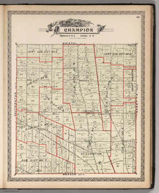
1899 Champion, Trumbull County, Ohio. County Atlas Map of Champion. |

1899 Bristol, Trumbull County, Ohio. County Atlas Map of Bristol. |

1899 Bloomfield, Trumbull County, Ohio. County Atlas Map of Bloomfield. |

1899 Newton, Trumbull County, Ohio. County Atlas Map of Newton. |

1899 Bracevlle, Trumbull County, Ohio. County Atlas Map of Bracevlle. |

1899 Southington, Trumbull County, Ohio. County Atlas Map of Southington. |

1899 Farmington, Trumbull County, Ohio. County Atlas Map of Farmington. |

1899 Mesopotamia, Trumbull County, Ohio. County Atlas Map of Mesopotamia. |

1899 Outline Map of Niles City. Outline Map o … County Atlas Outline Map of Niles City. Outline Map o … |

1899 North Part of the City of Warren, Ohio. County Atlas Map of North Part of the City of Warren. |

1899 West Part of the City of Niles, Ohio. County Atlas Map of West Part of the City of Niles. |

1899 Girard Village, Ohio. County Atlas Map of Girard Village. |

1899 Mineral Ridge Village, Ohio. County Atlas Map of Mineral Ridge Village. |

1899 Cortland Village, Ohio. County Atlas Map of Cortland Village. |

1899 Newton Falls Village, Ohio. County Atlas Map of Newton Falls Village. |