Browse All

1899 Farmington, Trumbull County, Ohio. County Atlas Map of Farmington. |

1899 Mesopotamia, Trumbull County, Ohio. County Atlas Map of Mesopotamia. |

1899 Outline Map of Niles City. Outline Map o … County Atlas Outline Map of Niles City. Outline Map o … |

1899 North Part of the City of Warren, Ohio. County Atlas Map of North Part of the City of Warren. |

1899 West Part of the City of Niles, Ohio. County Atlas Map of West Part of the City of Niles. |

1899 Girard Village, Ohio. County Atlas Map of Girard Village. |

1899 Mineral Ridge Village, Ohio. County Atlas Map of Mineral Ridge Village. |

1899 Cortland Village, Ohio. County Atlas Map of Cortland Village. |

1899 Newton Falls Village, Ohio. County Atlas Map of Newton Falls Village. |

1899 Kinsman P.O., Ohio. County Atlas Map of Kinsman P.O. |

1899 West Farmington Village. Deforest P.O., … County Atlas West Farmington Village. Deforest P.O. |

1899 Plats East of Vienna Center. Map of Leav … County Atlas Plats East of Vienna Center. Map of Leav … |

1899 Brookfield Center. (Other areas in Trumb … County Atlas Map of Brookfield Center. (Other areas i … |

1899 Orangeville Village. Hartford Centre. Vi … County Atlas Map of Orangeville Village. Map of Hartf … |
1899 North Bloomfield P.O. Farmington P.O. Lo … County Atlas Map of North Bloomfield P.O. Farmington … |

1899 West Metts. Mesopotamia. Bristolvill. Bo … County Atlas Map of West Metts P.O. Mesopotamia P.O. … |

1899 Church Hill. Ohlton, Meander. Coalburg. … County Atlas Map of Church Hill P.O. Map of Ohlton, M … |

1899 Text: Public Lands of Ohio. County Atlas (Text Page) Public Lands of Ohio. |

1899 Alaska. County Atlas Alaska (insets) Cook Inlet and Vicinity. … |

1899 South Part of the City of Warren, Ohio. County Atlas Map of South Part of the City of Warren. |

1899 Composite Map: Warren, Ohio. County Atlas (Composite Map) Warren. |

1899 East Part of the City of Niles, Ohio. County Atlas Map of East Part of the City of Niles. |

1899 Composite Map: Niles, Ohio. County Atlas (Composite Map) City of Niles. |

1899 Hubbard Village, Ohio. County Atlas Map of Hubbard Village. |

1852 Sing-Sing, Westchester County, New York. Wall Map Map of Sing-Sing, Westchester County, N. … |

1878 Richmond, Virginia. World Atlas Map of Richmond, Henrico County, Virgini … |

1878 Edinburg, Virginia. World Atlas Edinburg, Shenandoah County, Virginia. |

1878 Woodstock, Virginia. World Atlas Woodstock, Shenandoah County, Virginia. |

1878 Mt. Jackson and New Market, Virginia. World Atlas Mt. Jackson, Shenandoah County, Virginia … |

1877 Lexington, Virginia. World Atlas Gray's New Map of Lexington, Rockingham … |

1878 Luray, Virginia World Atlas Luray, Page County, Virginia. |

1878 Newtown, Virginia. World Atlas Newtown, (Newtown-Stephenburgh P.O.), Fr … |
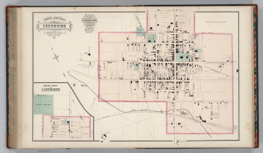
1878 Leesburg, Virginia. World Atlas Gray's New Map of Leesburg, Loudoun Co., … |

1878 Strasburg, Virginia. World Atlas Strasburg, Shenandoah County, Virginia. |
1877 Charlottesville,Virginia. World Atlas Gray's New Map of Charlottesville, Albem … |

1878 Orange Court House, Virginia. World Atlas Map of Orange Court House, Orange County … |

1878 Culpepper, Virginia. World Atlas Gray's New Map of Culpepper, Culpepper C … |

1878 Gordonsville and Harrisonburg, Virginia. World Atlas Gray's New Map of Gordonsville, Orange C … |

1877 Harrisonburg, Virginia. World Atlas Gray's New Map of Harrisonburg, Rockingh … |

1877 Bridgewater, Virginia. World Atlas Gray's New Map of Bridgewater, Rockingha … |

1877 Text Page (1): Professional Directory of … World Atlas (Text Page) The National Atlas. Professi … |

1877 Text Page (2-3): Professional Directory … World Atlas (Text Page) The National Atlas. Professi … |

1877 Text Page (4-5): Professional Directory … World Atlas (Text Page) The National Atlas. Professi … |