Who What Where WhenREMOVE |
Author
Colton, G.W & C.B.
Full Title
Colton's Railroad And Military Map Of The United States, Mexico, The West Indies &c. Published By G.W. & C.B. Colton, 172 William St. New York. 1865. Printed by Cooper 117 Fulton St. N.Y. (inset) Colton's Map Of The Americas, Africa And A Portion Of Europe, Showing The Atlantic And Part Of The Pacific Oceans. (8 additional inset maps).
Publisher
G.W. & C.B. Colton.
Author
Colton, G.W. & C.B.
Full Title
Colton's New Rail Road & County Map Of The United States, The Canadas &c. Published By G.W. And C.B. Colton, 172 William St. New York. (inset) Colton's Map Of The United States showing the Proposed Railroad Routes To The Pacific Ocean. (inset) Southern Part Of Florida.
Publisher
G.W. & C.B. Colton.
Author
[Fisher, Richard Swainson, Dinsmore & Co.]
Full Title
Dinsmore's Complete Map Of The Railroads & Canals In The United States & Canada Carefully Compiled from Authentic Sources by Richard S. Fisher, Editor Of The American Rail Road & Steam Navigator Guide. New-York. Published By Dinsmore & Company, No. 9 Spruce St. Engraved In Relief For Power Press Printing by Schonberg & Co. Acrographers, 75 Nassau Street New York 1856. Entered ... 1856 by Dinsmore & Co. ... New York.
Publisher
Dinsmore & Company
Author
Colton, G.W. & C.B.
Full Title
(Covers to) Colton's New Rail Road & County Map Of The United States, The Canadas &c. 1871. Published By G.W. And C.B. Colton, 172 William St. New York. Entered ... 1869 by G.W. & C.B. Colton & Co ... New York. (inset) Colton's Map Of The United States showing the Proposed Railroad Routes To The Pacific Ocean. (inset) Southern Part Of Florida.
Publisher
G.W. & C.B. Colton & Co.
Author
Tanner, Henry S.
Full Title
The Traveller's Guide Or Map Of The Roads, Canals & Rail Roads of the United States With the distances from place to place. By H.S. Tanner 1846. Published by H.S Tanner, 144 Chestnut St. Philadelphia. Entered ... 1844, by H.S. Tanner ... Pennsylvania. (with 11 inset maps).
Publisher
H.S. Tanner
Author
Rand McNally and Company
Full Title
United States. Rand, McNally & Co., Map Publishers and Engravers, Chicago, 1898. Rand, McNally & Co.'s New Business Atlas Map of the United States. Copyright, 1895, by Rand, McNally & Co. (inset) Alaska. (on verso) Chicago To Denver. Rand, McNally & Co.'s New Commercial Railroad Map of the United States. Copyright, 1898, ... 1896 ... (with) East of Chicago ... (with 2 inset maps). (on verso) Denver To Pacific Coast ...
Publisher
Rand McNally & Co.
Author
Rand McNally and Company
Full Title
(Rand, McNally & Co.'s New Official Railroad Map Of The United States And Dominion Of Canada). Compiled from the most reliable sources, and engraved by Rand, McNally & Co., Map Engravers and Publishers, 160-174 Adams Street, Chicago, Ill. The Rand-McNally Railway Guide Map. Copyright, 1901, ... 1892 ... (with 8 inset maps).
Publisher
Rand McNally & Co.
Author
Rand McNally and Company
Full Title
Rand McNally New Official Railroad Map Of The United States And Southern Canada. Copyright, by Rand McNally & Co.
Publisher
Rand McNally & Co.
Author
Watson, Gaylord
Full Title
The American Republic and rail-road map of the United States, British Provinces, West-Indies, Mexico and Central America. Compiled from the latest official sources. Published by Gaylord Watson, 16 Beekman Street, New York. 1867. Entered ... 1866, by Gaylord Watson ... New York. Engraved by Fisk & Russell, N. York.
Publisher
Gaylord Watson
Author
Rand McNally and Company
Full Title
Rand McNally standard map of the United States. Copyright by Rand McNally & Company, Chicago. Made in U.S.A.
Publisher
Rand McNally
Author
Smith, J. Calvin
Full Title
A New Map For Travelers Through the United States of America Showing the Railroads, Canals & Stage Roads, With The Distances, by J. Calvin Smith. Published by Sherman & Smith New-York. MDCCCLII. Entered ... 1846, by J. Calvin Smith ... New York. (inset) Map Of Oregon Northern California Santa Fe &c. (4 additional inset maps).
Publisher
Sherman & Smith
Author
Smith, J. Calvin
Full Title
A New Map For Travelers Through the United States of America Showing the Railroads, Canals & Stage Roads, With The Distances, by J. Calvin Smith. Published by Sherman & Smith New-York. MDCCCLIII. Entered ... 1846, by J. Calvin Smith ... New York. (inset) Map Of Oregon Northern California Santa Fe &c. (4 additional inset maps).
Publisher
Sherman & Smith
Author
Goldthwait, J.H.
Full Title
Goldthwait's Map Of The United States, British Provinces, Mexico, Central America, W. India Is. &c. Exhibiting The Railroads ... by J.H. Goldthwait. Published by D. Chester, 119 & 121 Nassau St. New York. Entered ... 1861 by J.H. Goldthwait ... New York. (inset) Great Rail Road Routes from the Middle Atlantic Ports To The Mississippi River by J.H. Goldthwait. (inset) Of The Railroads Of New England And Eastern N . York by J.H. Goldthwait.
Publisher
D. Chester
Author
Perris, William
Full Title
A New And Complete Rail Road Map Of The United States, Compiled from Reliable Sources by William Perris, C.E. & Surveyor, New York. Presented by the Home Insurance Company of New York ... Office Nos. 112 & 114 Broadway ... Korff Brothers Practical Lithographers 54 William St. New York.
Publisher
Korff Brothers
Author
Colton, G.W. & C.B.
Full Title
Colton's Railroad & Commercial Atlas Of The United States, Canada Etc. Map No. 5. Michigan, Wisconsin & Minnesota. Published by G.W. & C.B. Colton. & Co. New York, 1869.
Publisher
G.W. & C.B. Colton
Author
Lloyd, J.T.
Full Title
Lloyd's New Map of the United States The Canadas And New Brunswick From the latest Surveys Showing Every Railroad & Station Finished to June 1863 And The Atlantic And Gulf Coasts ... 1863 ... Address J.T. Lloyd, No. 164 Broadway, New York, and 1 Strand, London, England. Entered ... 1863, by J.T. Lloyd ... New York.
Publisher
J.T. Lloyd
Author
[Dripps, Matthew, Rand McNally and Company]
Full Title
New Official Railroad Map Of The United States And Canada. Address, M. Dripps, 111 & 113, Fulton Street, New York. Copyright, 1883, by Rand, McNally & Co. Map Publishers, Chicago. (inset) Map Of Atlantic Coast States Engraved On Enlarged Scale. (with 8 additional inset maps).
Publisher
M. Dripps
Author
Rand McNally and Company
Full Title
Rand, McNally & Co.'s New Commercial Map Of The United States And Canada Showing All The Railroads, Counties and Principal Towns Up To Date. Constructed from the latest Government and Railroad Surveys. 1883. Engraved And Published By Rand, McNally & Co., Map Publishers, Chicago. Copyright, 1883, by Rand, McNally & Co. ...
Publisher
Rand McNally and Co.
Author
Colton, G.W. & C.B.
Full Title
Colton's Railroad & Commercial Atlas Of The United States, Canada Etc. Map No. 6. Delaware, Maryland, Virginia, West Virginia, N. Carolina, Kentucky & Tennessee. Published by G.W. And C.B. Colton, & Co. 172 William St. New York. 1870. Entered ... 1866, by G.W. & C.B. Colton & Co ... N.Y.
Publisher
G.W. & C.B. Colton
Author
Poor, Henry Varnum
Full Title
Map of all the Railroads In The United States in Operation and Progress. Published by H.V. Poor, Editor of "The American Railroad Journal," 9 Spruce St., N.Y. D. McLellan, Lithographer, 26 Spruce St. New York.
Publisher
H.V. Poor
Author
[Rand McNally and Company, Smith, J.L.]
Full Title
Rand, McNally & Co.'s New Official Railroad Map Of The United States, Canada And Mexico. Engraved And Printed By Rand, McNally & Co., Chicago. 1889. Rand, McNally & Co., Map Publishers and Engravers, Chicago And New York. Copyright, 1889, by Rand, McNally & Co. Map Publishers, Chicago. (inset) Map Of Atlantic Coast States Engraved On Enlarged Scale. (with 8 additional inset maps).
Publisher
J.L. Smith
Author
Ensign, Bridgman & Fanning
Full Title
Ensign, Bridgman & Fanning's Rail Road Map Of The United States Showing the Depots & Stations. Published at No. 156 William St. N.Y. 1860. Printed by D. & J. McLellan, 26 Spruce St. N.Y. Entered ... 1856, by Ensign, Bridgman & Fanning ... New York. (inset) Plan of the New England States.
Publisher
Ensign, Bridgman & Fanning
Author
Rand McNally and Company
Full Title
Pennsylvania Railroad Great Trunk Line, and United States mail route ... copyright, 1881, by Rand, McNally & Co., Chicago ... (inset) Vicinity of Boston. (inset) Vicinity of New York and Philadelphia.
Publisher
Rand McNally & Co.
Author
[Central Pacific Railroad Company, Union Pacific Railroad Company]
Full Title
New map of the American Overland Route showing its connections, and land grants of 30,000,000 acres. Rand, McNally & Co., Chicago. (1879)
Author
[New York Central Railroad Company, Rand McNally and Company]
Full Title
Map of the United States showing the New York Central Lines and connections ... Copyright, Rand McNally & Company. (inset map) Atlantic Ocean and surrounding countries. (inset map) The water level route, New York Central Lines. (1929)
Publisher
Rand McNally
Author
Rand McNally and Company
Full Title
Rand, McNally & Co's. New Commercial Railroad Map Of The United States With Portions Of The Dominion Of Canada, The Republic Of Mexico, And The West Indies. Compiled from the most reliable sources, and engraved by Rand, McNally & Co., Map Engravers and Publishers, 160-174 Adams Street, Chicago, Ill. 1907.
Publisher
Rand McNally & Co.
Author
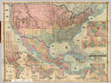
Colton, G.W & C.B.
Full Title
(Covers to) Colton's Railroad And Military Map Of The United States, Mexico, The West Indies &c. By J.H. Colton, New York, 1862. Entered ... 1862, by J.H. Colton ... New York.
Publisher
G.W. & C.B. Colton.
Author
[Mitchell, Samuel Augustus, Drake, Ira S.]
Full Title
Mitchell's New Traveller's Guide Through The United States, Containing The Principal Cities, Towns &c. ... Illustrated By An Accurate Map Of The United States. Philadelphia: Thomas, Cowperthwait & Co. 1853. (on verso) Entered ... 1848, by Thomas, Cowperthwait & Co. ... Pennsylvania. Stereotyped by J. Fagan. Printed by Smith & Peters. (with map) Mitchell's New Traveller's Guide Through The United States, Showing the Rail Roads, Canals, Stage Roads &c. ... Drawn and Engraved by Ira S. Drake. Philadelphia 1854. Published by Thomas, Cowperthwait & Co. Entered ... 1848, by Thomas, Cowperthwait, & Co. ... Pennsylvania. (with 5 inset maps).
Publisher
Thomas, Cowperthwait & Co.
Author
Colton, G.W. & C.B.
Full Title
(Covers to) Colton's New Rail Road & County Map Of The United States, The Canadas &c. Published By G.W. And C.B. Colton, 172 William St. New York. (inset) Colton's Map Of The United States showing the Proposed Railroad Routes To The Pacific Ocean. (inset) Southern Part Of Florida.
Publisher
G.W. & C.B. Colton.
Author
[Fisher, Richard Swainson, Dinsmore & Co.]
Full Title
(Covers to) Dinsmore's Complete Map Of The Railroads & Canals In The United States & Canada Carefully Compiled from Authentic Sources by Richard S. Fisher, Editor Of The American Rail Road & Steam Navigator Guide. New-York. Published By Dinsmore & Company, No. 9 Spruce St. Engraved In Relief For Power Press Printing by Schonberg & Co. Acrographers, 75 Nassau Street New York 1856. Entered ... 1856 by Dinsmore & Co. ... New York.
Publisher
Dinsmore & Company
Author
Colton, G.W. & C.B.
Full Title
(Covers to) Colton's New Rail Road & County Map Of The United States, The Canadas &c. 1871. Published By G.W. And C.B. Colton, 172 William St. New York. Entered ... 1869 by G.W. & C.B. Colton & Co ... New York. (inset) Colton's Map Of The United States showing the Proposed Railroad Routes To The Pacific Ocean. (inset) Southern Part Of Florida.
Publisher
G.W. & C.B. Colton & Co.
Author
Mitchell, Samuel Augustus
Full Title
Mitchell's Map Of The United States Showing the Principal Travelling, Turnpike and Common Roads ... Philadelphia: Published By S. Augustus Mitchell. 1838. Sold by Mitchell & Hinman. No. 6 North Fifth Street. Entered ... 1835, by S. Augustus Mitchell... Pennsylvania. (with 8 inset maps. (with) Mitchell's Compendium Of The Internal Improvements Of The United States; Comprising General Notices Of All The Most Important Canals and Rail-Roads... Philadelphia: Published By Mitchell & Hinman, No. 6, North-Fifth Street. 1838. (on verso) Entered ... 1835, by Mitchell & Hinman ... Pennsylvania. Stereotyped by John Fagan ... Philadelphia.
Publisher
Mitchell and Hinman
Author
[Mitchell, Samuel Augustus, Young, James H., Drake, Ira S., Hazzard, John L.]
Full Title
A New Map Of The United States of America. By J.H. Young. Philadelphia. (with 2 inset maps) Gold Regions of California and District of Columbia. Published by Charles Desilver, No. 253 Market St.
Publisher
Charles Desilver
Author
[Mitchell, Samuel Augustus, Young, James H., Drake, Ira S., Hazzard, John L.]
Full Title
Mitchell's New Traveller's Guide Through The United States, Showing the Rail Roads, Canals, Stage Roads &c. With Distances from Place to Place. Drawn and Engraved by I.S. Drake & J.L. Hazzard. Philadelphia 1856. (with 5 inset maps) Map of New England or Eastern States; Map of Maritime and Overland Routes to California; Map of the Gold and Quicksilver District of California; Map of Coper Mine Region; Vicinity of Niagara Falls. Published by Charles Desilver, No. 253 Market St. Entered ... 1856 by Charles Desilver... Pennsylvania.
Publisher
Charles Desilver
Author
Tanner, Henry S.
Full Title
(Covers to) The Traveller's Guide Or Map Of The Roads, Canals & Rail Roads of the United States With the distances from place to place. By H.S. Tanner 1846. Published by H.S Tanner, 144 Chestnut St. Philadelphia. Entered ... 1844, by H.S. Tanner ... Pennsylvania. (with 11 inset maps).
Publisher
H.S. Tanner
Author
Rand McNally and Company
Full Title
(Covers to) United States. Rand, McNally & Co., Map Publishers and Engravers, Chicago, 1898. Rand, McNally & Co.'s New Business Atlas Map of the United States. Copyright, 1895, by Rand, McNally & Co. (inset) Alaska. (on verso) Chicago To Denver. Rand, McNally & Co.'s New Commercial Railroad Map of the United States. Copyright, 1898, ... 1896 ... (with) East of Chicago ... (with 2 inset maps). (on verso) Denver To Pacific Coast ...
Publisher
Rand McNally & Co.
Author
Rand McNally and Company
Full Title
(Covers to) (Rand, McNally & Co.'s New Official Railroad Map Of The United States And Dominion Of Canada). Compiled from the most reliable sources, and engraved by Rand, McNally & Co., Map Engravers and Publishers, 160-174 Adams Street, Chicago, Ill. The Rand-McNally Railway Guide Map. Copyright, 1901, ... 1892 ... (with 8 inset maps).
Publisher
Rand McNally & Co.
Author
Rand McNally and Company
Full Title
(Covers to) Rand McNally New Official Railroad Map Of The United States And Southern Canada. Copyright, by Rand McNally & Co.
Publisher
Rand McNally & Co.
Author
Watson, Gaylord
Full Title
(Covers to) The American Republic and rail-road map of the United States, British Provinces, West-Indies, Mexico and Central America. Compiled from the latest official sources. Published by Gaylord Watson, 16 Beekman Street, New York. 1867. Entered ... 1866, by Gaylord Watson ... New York. Engraved by Fisk & Russell, N. York.
Publisher
Gaylord Watson
Author
Watson, Gaylord
Full Title
(Inside Covers to) The American Republic and rail-road map of the United States, British Provinces, West-Indies, Mexico and Central America. Compiled from the latest official sources. Published by Gaylord Watson, 16 Beekman Street, New York. 1867. Entered ... 1866, by Gaylord Watson ... New York. Engraved by Fisk & Russell, N. York.
Publisher
Gaylord Watson
Author
Goldthwait, J.H.
Full Title
(Covers to) Goldthwait's Map Of The United States, British Provinces, Mexico, Central America, W. India Is. &c. Exhibiting The Railroads ... by J.H. Goldthwait. Published by D. Chester, 119 & 121 Nassau St. New York. Entered ... 1861 by J.H. Goldthwait ... New York. (inset) Great Rail Road Routes from the Middle Atlantic Ports To The Mississippi River by J.H. Goldthwait. (inset) Of The Railroads Of New England And Eastern N . York by J.H. Goldthwait.
Publisher
D. Chester
Author
Perris, William
Full Title
(Covers to) A New And Complete Rail Road Map Of The United States, Compiled from Reliable Sources by William Perris, C.E. & Surveyor, New York. Presented by the Home Insurance Company of New York ... Office Nos. 112 & 114 Broadway ... Korff Brothers Practical Lithographers 54 William St. New York.
Publisher
Korff Brothers
Author
Colton, G.W. & C.B.
Full Title
(Covers to) Colton's Railroad & Commercial Atlas Of The United States, Canada Etc. Map No. 5. Michigan, Wisconsin & Minnesota. Published by G.W. & C.B. Colton. & Co. New York, 1869.
Publisher
G.W. & C.B. Colton
Author
Lloyd, J.T.
Full Title
(Covers to) Lloyd's New Map of the United States The Canadas And New Brunswick From the latest Surveys Showing Every Railroad & Station Finished to June 1863 And The Atlantic And Gulf Coasts ... 1863 ... Address J.T. Lloyd, No. 164 Broadway, New York, and 1 Strand, London, England. Entered ... 1863, by J.T. Lloyd ... New York.
Publisher
J.T. Lloyd
Author
[Dripps, Matthew, Rand McNally and Company]
Full Title
(Covers to) New Official Railroad Map Of The United States And Canada. Address, M. Dripps, 111 & 113, Fulton Street, New York. Copyright, 1883, by Rand, McNally & Co. Map Publishers, Chicago. (inset) Map Of Atlantic Coast States Engraved On Enlarged Scale. (with 8 additional inset maps).
Publisher
M. Dripps
Author
Rand McNally and Company
Full Title
(Covers to) Rand, McNally & Co.'s New Commercial Map Of The United States And Canada Showing All The Railroads, Counties and Principal Towns Up To Date. Constructed from the latest Government and Railroad Surveys. 1883. Engraved And Published By Rand, McNally & Co., Map Publishers, Chicago. Copyright, 1883, by Rand, McNally & Co. ...
Publisher
Rand McNally and Co.
Author
Colton, G.W. & C.B.
Full Title
(Covers to) Colton's Railroad & Commercial Atlas Of The United States, Canada Etc. Map No. 6. Delaware, Maryland, Virginia, West Virginia, N. Carolina, Kentucky & Tennessee. Published by G.W. And C.B. Colton, & Co. 172 William St. New York. 1870. Entered ... 1866, by G.W. & C.B. Colton & Co ... N.Y.
Publisher
G.W. & C.B. Colton
|