Who What Where WhenREMOVEWHERE
|
Author
Rand McNally and Company
Full Title
Rand McNally Standard Map Of New York. The Rand McNally New Commercial Atlas Map of New York. Copyright by Rand McNally & Co. (inset) Northern Portion Of New York. (inset) Long Island Extension. (on verso) Rand McNally Main Highway Map Of New York ... (with 86 page index) Rand McNally Indexed Pocket Map Tourists' And Shippers' Guide Of New York ... Rand McNally & Company, Chicago 536 S. Clark St., New York 42 E. 22 St. (on verso) Copyright, 1921, by Rand, McNally & Co., Chicago.
Publisher
Rand McNally & Co.
Author
Rand McNally and Company
Full Title
Rand, McNally & Co.'s Colorado. Rand McNally & Co., Map Publishers and Engravers, Chicago, 1907. Rand, McNally & Co.'s New Business Atlas Map of Colorado. Copyright, 1906, ... 1904 ... (with 33 page index) Rand, McNally & Co.'s Indexed County And Township Pocket Map And Shippers' Guide Of Colorado ... Chicago And New York: Rand, McNally & Co. ... (on verso) Copyright, 1907, by Rand, McNally & Co., Chicago.
Publisher
Rand McNally & Co.
Author
Rand McNally and Company
Full Title
Rand, McNally & Co.'s Colorado. Rand McNally & Co., Map Publishers and Engravers, Chicago, 1912. The Rand-McNally & Co.'s New Commercial Atlas Map of Colorado. Copyright by Rand-McNally & Co. (with 62 page index) Rand McNally & Co.'s Indexed County And Township Pocket Map And Shippers' Guide Of Colorado ... Chicago And New York: Rand McNally & Co. ... (on verso) Copyright, 1912, by Rand, McNally & Co., Chicago.
Publisher
Rand McNally & Co.
Author
Rand McNally and Company
Full Title
Rand, McNally & Co.'s Wyoming. Rand, McNally & Co., Map Publishers and Engravers, Chicago, 1909. Rand, McNally & Co.'s Indexed Atlas of the World Map of Wyoming. Copyright, 1909, ... 1895 ... (with 15 page index) Rand McNally & Co.'s Indexed County And Railroad Pocket Map And Shippers' Guide Of Wyoming ... Chicago And New York: Rand McNally & Co. ... (on verso) Copyright, 1909, Rand, McNally & Co., Chicago.
Publisher
Rand McNally & Co.
Author
Rand McNally and Company
Full Title
Rand McNally New Official Railroad Map Of The United States And Southern Canada. Copyright, by Rand McNally & Co.
Publisher
Rand McNally & Co.
Author
Sinclair, Thomas
Full Title
Map of Mexico Showing the Seat of War. Lith. of T. Sinclair, 79 So. 3rd St. Philadelphia.
Publisher
Thomas Sinclair
Author
Texas Land and Immigration Company
Full Title
Map of the state of Texas. Woodward, Tiernan & Hale, Map Engr's St. Louis. Texas Land and Immigration Co. St. Louis, Mo. (1876)
Publisher
Woodward, Tiernan & Hale
Author
Rand McNally and Company
Full Title
Texas. Rand, McNally & Co's New Business Atlas Map of Texas. Copyright, 1910 ... 1903 ... Rand McNally & Co., Map Publishers and Engravers, Chicago, 1910. (two untitled inset maps of the northern and southern tips of Texas).
Publisher
Rand McNally and Company
Author
Colton, G.W. & C.B.
Full Title
Colton's Railroad & Township Map of the State of Ohio. Published By G.W. & C.B. Colton, No. 172 William St. New York. 1867. Entered ... 1851 by J.H. Colton ... New York.
Publisher
G.W. & C.B. Colton
Author
Cram, George Franklin
Full Title
Cram's Railroad & County Map Of Virginia, W. Virginia, Maryland & Delaware. Published By Geo. F. Cram. Proprietor Of The Western Map Depot. 262-264 Wabash, Ave. Chicago, Ills. 1881. Entered ... 1878, by G.F. Cram... Washington D.C.
Publisher
George F. Cram
Author
Cram, George Franklin
Full Title
Cram's Township And Rail Road Map Of The North West. Published By George F. Cram, Proprietor Of The Western Map Depot. 66 Lake St.: Chicago, Ills. 1878. Entered ... 1878, by G.F. Cram ... Washington D.C.
Publisher
George F. Cram
Author
Lloyd, J. T.
Full Title
Lloyd's official map of the state of Tennessee. Compiled from actual surveys and official documents, showing every rail road & rail road station with the distances between each station ... 1863. New York, J.T. Lloyd, Publisher, 164 Broadway. Price. 50 cents each, colored in sheets ... Entered ... 1862 by J.T. Lloyd ... N. York. (with) Eastern part of Tennessee.
Publisher
J.T. Lloyd
Author
Watson, Gaylord
Full Title
The American Republic and rail-road map of the United States, British Provinces, West-Indies, Mexico and Central America. Compiled from the latest official sources. Published by Gaylord Watson, 16 Beekman Street, New York. 1867. Entered ... 1866, by Gaylord Watson ... New York. Engraved by Fisk & Russell, N. York.
Publisher
Gaylord Watson
Author
White Pass & Yukon Route
Full Title
Map Of White Pass & Yukon Route And Connections. White Pass & Yukon Route ... Copyright, 1917, by White Pass & Yukon Route. (inset) Map of Atlin Lake District. Poole Bros. Chicago. (Ed. of) 4-10-'22.
Publisher
White Pass & Yukon Route
Author
Goldthwait, J.H.
Full Title
Railroad Map Of New England & Eastern New York, Compiled from the most authentic sources. By J.H. Goldthwait. 1849. Boston. Redding & Co. 8 State St. New York. Clark, Austin & Co. 205 Broadway. Entered ... 1849, by J.H. Goldthwait ... New York. (inset) Boston & Vicinity, Showing the Grand Junction R.R.
Publisher
Redding & Co.
Author
Colton, J.H.
Full Title
Colton's Railroad & Township Map Of The State Of Maine With Portions Of New Hampshire, New Brunswick & Canada. Published By J.H. Colton And Co. No. 172 William St. New York, And C.C. Hall, Portland, Maine. 1855. Entered ... 1855 by J.H. Colton ... New York.
Publisher
[J.H. Colton, C.C. Hall]
Author
Cram, George
Full Title
Cram's Rail Road & Township Map of Minnesota. Published By Geo. F. Cram. Proprietor Of The Western Map Depot. 262-264. Wabash, Ave. Chicago, Ills. Entered ... 1878 by G.F. Cram ... Washington, D.C.
Publisher
George Cram
Author
Cooke, D.B & Co.
Full Title
D.B. Cooke & Co.'s Great Western Railway Guide. Exhibiting All Stations With Distances From Each other. Chicago, 1856. Entered ... 1856 by D.B. Cooke & Company. Middleton Wallace & Co. Lith. Cincinnati.
Publisher
Cooke, D.B & Co.
Author
Dodge, J.R.
Full Title
Township and Railroad Map Of New Hampshire, Compiled from the best authorities ... 1854. Published by J.R. Dodge, Nashua, N.H. L.H. Bradford & Co.'s Boston. Entered ... 1854 by J.R. Dodge ... New Hampshire.
Publisher
J.R. Dodge
Author
[Frey, A.C., Nell, Louis]
Full Title
Frey & Nell's New England. Railroad, Topographical & Township Map of the States of Connecticut, Rhode Island, Massachusetts, Vermont, New Hampshire and Maine. New York, H.H. Lloyd & Co. Publishers, 21 John St. Concord, N.H. D.L. Guernsey & Co. 1867 ... American Photo-Lithographic Co. N. York. Osborne's Process. Entered ... 1867, by Frey & Nell ... New York. (untitled inset of Maine).
Publisher
[H.H. Lloyd & Co., D.L. Guernsey & Co.]
Author
Colton, J.H.
Full Title
Colton's Railroad & Township Map of the State of Ohio. Published By J.H. Colton, No. 172 William St. New York. 1860. Entered ... 1851 by J.H. Colton ... New York.
Publisher
J.H. Colton
Author
Colton, J.H.
Full Title
Colton's Railroad & Township Map, Western States Compiled From The United States Surveys. Published by J.H. Colton No. 86 Cedar Street, New York 1854. Printed at D. Mc. Lellan's 26 Spruce St. N.Y.
Publisher
J.H. Colton
Author
Colton, J.H.
Full Title
Colton's Railroad & Township Map, Western States Compiled From The United States Surveys. Published by J.H. Colton and Co. No. 172 William Street, New York. 1857. J.P. Cox Sc.
Publisher
J.H. Colton & Co.
Author
Smith, J. Calvin
Full Title
Sherman & Smith's Railroad, Steam Boat & Stage Route Map Of New England, New-York And Canada. By J. Calvin Smith. Published by Sherman & Smith 135 Broadway. N.Y. MDCCCL. Entered ... 1850 by Sherman & Smith ... (inset) 15 Miles Around Boston. (inset) 15 Miles Around New York.
Publisher
Sherman & Smith
Author
Rand McNally and Company
Full Title
Rand McNally standard map of the United States. Copyright by Rand McNally & Company, Chicago. Made in U.S.A.
Publisher
Rand McNally
Author
G.W. & C.B. Colton & Co.
Full Title
Map of the Richmond and Louisville R.R. connecting the railroads of Virginia with the railroads of Kentucky on the shortest route east and west from the Mississippi Valley to the Atlantic Ocean. Engraved, printed and manufactured by G.W. & C.B. Colton & Co. No. 182 William St. New York. Entered ... 1882 by G.W. & C.B. Colton & Co. ... at Washington.
Publisher
G.W. & C.B. Colton & Co.
Author
Rand McNally and Company
Full Title
Rand McNally standard map of Minnesota ... Copyright by Rand McNally & Company, Chicago ...
Publisher
Rand McNally
Author
Smith, J. Calvin
Full Title
A New Map For Travelers Through the United States of America Showing the Railroads, Canals & Stage Roads, With The Distances, by J. Calvin Smith. Published by Sherman & Smith New-York. MDCCCLII. Entered ... 1846, by J. Calvin Smith ... New York. (inset) Map Of Oregon Northern California Santa Fe &c. (4 additional inset maps).
Publisher
Sherman & Smith
Author
Smith, J. Calvin
Full Title
A New Map For Travelers Through the United States of America Showing the Railroads, Canals & Stage Roads, With The Distances, by J. Calvin Smith. Published by Sherman & Smith New-York. MDCCCLIII. Entered ... 1846, by J. Calvin Smith ... New York. (inset) Map Of Oregon Northern California Santa Fe &c. (4 additional inset maps).
Publisher
Sherman & Smith
Author
Watson, Gaylord
Full Title
Watson's New County and Railroad Map of the Pacific States Published by G. Watson, No. 16 Beekman Street, New York. 1876. Engraved by Louis E. Neuman, 36 Vesey St., New York. Entered ... 1874 by Gaylord Watson ... Washington.
Publisher
New York: Gaylord Watson
Author
Colton, J.H.
Full Title
Colton's Railroad & Township Map of the State of Ohio. Published By Johnson & Browning, No. 172 William St. New York. 1859. Entered ... 1851 by J.H. Colton ... New York. Drawn by George W. Colton. Engraved by J.M. Atwood, New York.
Publisher
Johnson & Browning
Author
Colton, G.W. & C.B.
Full Title
Map Of The Pacific Rail Road Route From The Mississippi River To The Pacific Ocean. Published By G.W. & C.B. Colton & Co. 172 William St. New York.
Publisher
G.W. & C.B. Colton & Co.
Author
Colton, G.W. & C.B.
Full Title
Colton's Railroad & Township Map Of The State Of New York, With Parts of the Adjoining States & Canada. Published by G.W. And C.B. Colton & Co. No. 172 William St. New York 1868. Entered ... 1852, by J.H. Colton ... N. York. Drawn by Geo. W. Colton.
Publisher
G.W. & C.B. Colton & Co.
Author
[Desilver, Charles, Young, James H.]
Full Title
A New Map Of The State Of Virginia Exhibiting Its Internal Improvements Roads Distances &c. by J.H. Young. Philadelphia: Published By Charles DeSilver 714 Chestnut St. 1859. Entered ... 1856 by Charles Desilver ... Pennsylvania. (inset) District Of Columbia.
Publisher
Charles Desilver.
Author
Goldthwait, J.H.
Full Title
Goldthwait's Map Of The United States, British Provinces, Mexico, Central America, W. India Is. &c. Exhibiting The Railroads ... by J.H. Goldthwait. Published by D. Chester, 119 & 121 Nassau St. New York. Entered ... 1861 by J.H. Goldthwait ... New York. (inset) Great Rail Road Routes from the Middle Atlantic Ports To The Mississippi River by J.H. Goldthwait. (inset) Of The Railroads Of New England And Eastern N . York by J.H. Goldthwait.
Publisher
D. Chester
Author
Perris, William
Full Title
A New And Complete Rail Road Map Of The United States, Compiled from Reliable Sources by William Perris, C.E. & Surveyor, New York. Presented by the Home Insurance Company of New York ... Office Nos. 112 & 114 Broadway ... Korff Brothers Practical Lithographers 54 William St. New York.
Publisher
Korff Brothers
Author
[Colton, J.H., Parker, Nathan H.]
Full Title
Parker's Sectional & Geological Map Of Iowa. Exhibiting her Iron Lead Copper Coal and other Geological Resources And All Rail Roads Completed, in progress, and projected. Compiled from the U.S. Surveys and personal reconnoisance. By Nathan H. Parker. Author of "Iowa As It Is" Clinton Io. 1856. J.H. Colton & Co. 172 William St. New York. D.B. Cooke & Co. Chicago Ill. Entered ... 1856, by N.H. Parker... Iowa. Engraved, Printed And Mounted By J.H. Colton & Co. 172 William Street, New York. (inset) Map Showing the Connections between the Iowa And Eastern Rail Roads.
Publisher
[J.H. Colton, D.B. Cooke]
Author
Colton, J.H.
Full Title
Colton's Railroad & Township Map Of The State Of New York, With Parts of the Adjoining States & Canada. Published by J.H. Colton & Co. No. 172 William St. New York 1855. Entered ... 1852, by J.H. Colton ... N. York. Drawn by Geo. W. Colton. J.M. Atwood Sculpt.
Publisher
J.H. Colton & Co.
Author
Poole Brothers
Full Title
Map Of The Mexican Central Railway And Connections. May, 1898.
Publisher
Poole Bros.
Author
Colton, G.W. & C.B.
Full Title
Colton's Railroad & Commercial Atlas Of The United States, Canada Etc. Map No. 5. Michigan, Wisconsin & Minnesota. Published by G.W. & C.B. Colton. & Co. New York, 1869.
Publisher
G.W. & C.B. Colton
Author
Hardee, T.S.
Full Title
Hardee's Geographical, Historical and Statistical Official Map Of Mississippi Embracing Portions Of Alabama, Arkansas, Louisiana And Tennessee, From Recent Surveys And Investigations And Officially Compiled Under Authority From The State Legislature By T.S. Hardee State Engineer A.D. 1872. Hugh Lewis, Lithographer And Publisher - New Orleans, LA. Entered ... 1872 By T.S. Hardee ... At Washington. G. Koeckert. Engraver. (inset) Rail Road And Geological Map Of Mississippi. (inset) Profile of Grades New Orleans, Jackson And Great Northern Rail Road... (insets) Statistical tables and Historical information.
Publisher
Hugh Lewis
Author
Lloyd, J.T.
Full Title
Lloyd's New Map of the United States The Canadas And New Brunswick From the latest Surveys Showing Every Railroad & Station Finished to June 1863 And The Atlantic And Gulf Coasts ... 1863 ... Address J.T. Lloyd, No. 164 Broadway, New York, and 1 Strand, London, England. Entered ... 1863, by J.T. Lloyd ... New York.
Publisher
J.T. Lloyd
Author
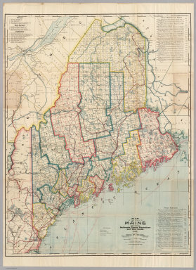
[Cram, George, Farrington, E.C.]
Full Title
Farrington's Map Of Maine, Together with the Index and Appendix Of Information ... E.C. Farrington, Augusta, Maine. (on verso) Index to State Map Of Maine. (with) Map Of The State Of Maine Showing Railroads, Towns, Plantations and Wild Lands. 1900. 61-63 Plymouth Place, Chicago, Ill. 130 Fulton Street, New York. Revised By Frank E. Oak, State Land Office, Augusta, Me. Copyright 1900 By E.C. Farrington, Augusta, Maine.
Publisher
E.C. Farrington
Author
Colton, G.W. & C.B.
Full Title
Colton's Map Of The Middle States Showing The Counties, Towns, Railroads, and Stations. Published By G.W. And C.B. Colton & Co. 172 William St. New York. 1874. Entered ... 1872 by G.W. & C.B. Colton & Co. ... Washington.
Publisher
G.W. & C.B. Colton
Author
Colton, J.H.
Full Title
Colton's Railroad & Township Map of the State of Ohio. Published By J.H. Colton, No. 172 William St. New York. 1864. Entered ... 1851 by J.H. Colton ... New York.
Publisher
J.H. Colton
Author
Norton, J.A.
Full Title
Railroad Map Of Ohio. Published By The State. 1890. Prepared By J.A. Norton, Commissioner of Railroads & Telegraphs. Columbus, Ohio. H.B. Stranahan & Co. Map Engravers & Publishers, Cleveland, Ohio. Copyright 1890 by H.B. Stranahan.
Publisher
State of Ohio
Author
Williams, A. & Co.
Full Title
A. Williams & Co. Railroad & Township Map Of Massachusetts. Published at the Boston Map Store. 283 Washington St. 1878. Entered ... 1876 by Cook and Ellis ... Washington D.C. Lith. by J. Mayer & Co. No 4 State St.
Publisher
The Boston Map Store
Author
Thayer, Horace & Co.
Full Title
Railroad & Township Map Of Ohio. Published By Horace Thayer & Co. 50 Ann St. New York. 1853. Entered ... 1851 by Ensign, Thayer & Co. ... New York. W.S. Barnard Sc. J. Wells Del.
Publisher
Horace Thayer & Co.
Author
[Rand McNally and Company, Watson, Gaylord]
Full Title
New Railroad, County and Township Map Of New York Showing Every Railroad Station and Post Office in the State. Address, Gaylord Watson, 278 Pearl Street, New York. 1887. Copyright, 1887, by Rand, McNally & Co., Map Publishers, Chicago. (with 3 inset maps).
Publisher
Gaylord Watson
|